
BIRM-166’s Silted Tundra30415 BCE
30,415 BCE is a modern label rather than a recoverable Irish historical year. At Derryvree, County Fermanagh, organic freshwater silts between two tills, dated BIRM-166, indicate a broad later Marine Isotope Stage 3 interval when tundra, wetlands and sparse treeless vegetation survived between glacial advances. Plant and insect remains record cold, freshwater habitats, while later ice obscured much earlier evidence. Ireland experienced unstable climates, shifting ice margins and changing connections with Britain and Europe. Castlepook Cave preserves diverse cold-stage fauna and a possibly tool-marked reindeer bone, suggesting brief human presence, but no secure evidence establishes permanent settlement, society or events.
Dateline
30,415 BCE is a modern calendar label, not a recoverable year in Ireland’s human record. No Irish community then left writing, an annual calendar, a named leader, or a datable sequence of events from which archaeologists can identify what happened in that particular year. The date corresponds roughly to 32,364 years before AD 1950, the conventional reference point for “before present”. At this depth of time, radiocarbon determinations must be calibrated and are expressed responsibly as broad ranges, not as individual historical years.
The nearest substantial Irish evidence belongs to the Late Pleistocene, within Marine Isotope Stage 3, during the Midlandian cold stage. It is environmental evidence: sediment layers, fossil plants, insects, animal bones and the traces of moving ice. Together, these records show an Ireland undergoing severe climatic instability, with local ice-free landscapes and fresh water at some times and places, but with major ice-sheet expansion approaching. They do not reveal a kingdom, tribe, settlement or battle.
A Date with a Wide Margin
The key chronological witness is BIRM-166, a radiocarbon determination from organic freshwater sediments uncovered at Derryvree, near Maguiresbridge in County Fermanagh. Roadworks in 1969 exposed a remarkable section through a drumlin: a lower till, then silts and fine sands containing organic remains, followed by a further thick till. Till is debris laid down directly by glacier ice. The sequence therefore establishes an important order of events: ice had crossed the locality; an interval then allowed water, sediment and living organisms to accumulate; and later ice again overrode and sealed the deposit.
The original determination was 30,500 radiocarbon years BP, with a substantial uncertainty of +1,170 and −1,030 years. That is not the same as a calendar age. Carbon-14 levels in the atmosphere have changed through time, and calibration of such ancient samples produces wide probability ranges. The Derryvree result is best treated as evidence for a broad later MIS 3 interval, rather than a timestamp for one season, one generation or one notional year. It nonetheless makes Derryvree highly relevant to the world represented by 30,415 BCE.
This distinction is more than technical caution. The sediment accumulated over time and contains the remains of organisms drawn from a local catchment. A radiocarbon date applies to sampled carbon, within stated uncertainty; it does not date an entire landscape or identify the precise year in which a plant flowered, an insect flew or a glacier advanced. Modern calibration curves improve comparison with calendar time, but they do not turn Ireland’s deep prehistory into an annal.
Fresh Water Between the Tills
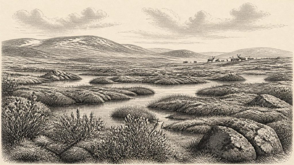
Derryvree is valuable because it preserves a landscape that later ice largely buried. The flora and fauna in its organic silts indicate open tundra vegetation and a periglacial regime: a cold environment at or near the margins of glaciation, where seasonal freezing and thawing shaped soils, drainage and plant cover. It was not an evergreen forest, nor a featureless snow desert. Rather, it was a mosaic of wet ground, shallow fresh water, sedge margins, moss-rich patches and exposed, sparsely vegetated terrain.
Plant remains reported from the deposit include grasses and sedges, mosses, bogbean, water-milfoil, dwarf willow, mountain-avens and lesser clubmoss. Their significance lies in combination. Bogbean and water-milfoil point to standing or slow-moving fresh water; sedges and mosses suggest saturated margins; dwarf willow and mountain-avens belong to cold, open settings. Pollen, macrofossils and insect evidence reinforce the conclusion that this part of Fermanagh supported a low, largely treeless vegetation cover rather than woodland.
That reconstruction should remain local. Derryvree demonstrates what existed in and around one protected freshwater basin, not a uniform landscape extending from Fermanagh to Cork, Kerry and the east coast. Ireland’s relief, snowfall, ice margins and water bodies were regionally varied. Yet the site establishes an essential point: at some stage broadly relevant to this date, ice did not cover every Irish locality continuously. Cold freshwater habitats could persist between glacial episodes.
Ice Gathering Across Ireland
The wider setting was one of climatic deterioration and changing ice extent. The most extensive phase of the last British–Irish Ice Sheet came later, broadly during the Last Glacial Maximum, conventionally placed around 26,000–20,000 years ago, although its timing and limits differed between regions. At about 30,415 BCE, Ireland was therefore not simply the fully ice-entombed island of popular imagination. It was part of a changing north-west European zone in which glaciers, permafrost-like ground conditions, open habitats and low sea levels altered repeatedly.
Reconstructions of the ice sheet are necessarily revised as new offshore cores, landforms, exposure ages and improved radiocarbon chronologies become available. The best inference is that ice growth was becoming increasingly important, while local ice-free or ice-marginal environments still existed. Subsequent glaciation is also a reason why the evidence is so scarce. Moving ice eroded old land surfaces, redeposited sediment and obscured possible campsites. The absence of known settlements from this period is meaningful, but it is not proof that every earlier trace was absent before the glaciers arrived.
Lower global sea level changed the shape of the surrounding seas and coastal plains. This made Ireland ecologically less isolated than it is today at some intervals, but it does not prove a simple, permanent land bridge or an easy route for people and animals. Ice, meltwater, exposed seabed, rivers, severe weather and shifting shorelines could each create barriers as well as corridors. The evidence supports changing connections with Britain and north-west Europe, not a mapped road into Ireland.
Animals and the Castlepook Question
Southern Irish caves offer another, more fragmentary route into this period. Castlepook Cave, near Doneraile in County Cork and long known as Mammoth Cave, produced a rich Pleistocene faunal collection during early twentieth-century excavations. Reassessment and redating have shown both its importance and its difficulty. Cave assemblages can accumulate over long periods through carnivore activity, natural deaths, water movement, roof collapse and excavations undertaken before modern recording standards. They are archives, not snapshots.
The broader Irish late-Pleistocene fauna includes reindeer, woolly mammoth, giant deer, brown bear, wolf, Arctic fox, lemmings and spotted hyaena. Not every animal was necessarily alive at Castlepook, or anywhere else in Ireland, at the same moment. Modern redating has demonstrated that some older cave measurements were misleadingly young and suggests that giant deer and spotted hyaena may have disappeared locally before the Last Glacial Maximum. The responsible conclusion is that Ireland supported, or was reached by, a changing cold-stage fauna across long spans of time.
A reindeer femur from Castlepook has particular importance. Ruth Carden has interpreted a deep mark on it as damage made by a sharp stone tool during butchery, and County Cork heritage material associates the object broadly with about 31,000 BCE. If that interpretation is sustained, the bone is possible evidence that people processed a reindeer in Ireland during the Upper Palaeolithic. It would be a strikingly early sign of human activity on the island.
It is not, however, proof of permanent occupation. No securely associated stone-tool assemblage, hearth, built shelter, burial, human skeletal remains, art or settlement surface of comparable age has been established in Ireland. Nor can one marked bone tell us whether people killed the animal, scavenged part of a carcass, butchered it in the cave, or whether carnivores later carried the discarded limb there. The evidence permits a cautious possibility of brief human presence; it does not permit an invented population, named culture or continuous ancestry.
Life, Society and What Cannot Be Claimed
There is no direct evidence for political affairs, diplomacy, formal warfare, trade networks, farming, seafaring communities or religious practice in Ireland at this date. There were no known towns, fields, monuments or institutions. If people did enter the island, comparison with Upper Palaeolithic groups elsewhere in Europe suggests that they would have needed mobility, knowledge of seasonal weather and animal behaviour, and effective stone-working skills. But this is a comparative inference, not an excavated Irish social history.
Likewise, the Derryvree wetland shows nothing of domestic routine beyond the ecological conditions upon which any visitor would have depended. Fresh water, aquatic plants and wetland margins could provide focal resources in a harsh landscape, while reindeer and other large herbivores would have been significant to predators and, potentially, to hunters. Yet no direct evidence identifies a camp beside the Fermanagh pools or a hunting strategy in the Cork limestone country.
The important development around this nominal date is environmental rather than political: Ireland lay within a highly unstable Ice Age world, and parts of it could sustain cold-adapted freshwater and tundra communities between phases of glaciation. Derryvree’s silts preserve that local world with unusual clarity. Castlepook’s bones show the wider animal richness of the period and hold open, but do not settle, the question of an exceptionally early human visit. For 30,415 BCE, that is the responsible history: frost-affected ground, shallow water, sparse vegetation, mobile animals and an island whose later ice would hide much of its deepest past.
Primary Sources
- A Middle Midlandian Freshwater Series at Derryvree, Maguiresbridge, County Fermanagh, Northern Ireland
- Early Midlandian–Middle Midlandian, Pleistocene, Northern Ireland
- Pleistocene Glaciations in Ireland
- Growth and Retreat of the Last British–Irish Ice Sheet, 31,000 to 15,000 Years Ago: The BRITICE-CHRONO Reconstruction
- Last Glacial Maximum Cirque Glaciation in Ireland and Implications for Reconstructions of the Irish Ice Sheet
- Radiocarbon Constraints on the Age of the Maximum Advance of the British–Irish Ice Sheet in the Celtic Sea
- Stratigraphic and Palaeo-Geomorphological Evidence for the Glacial-Deglacial History of the Last British-Irish Ice Sheet in the North-Western Irish Sea
- Early Deglaciation of the British-Irish Ice Sheet on the Atlantic Shelf Northwest of Ireland Driven by Glacioisostatic Depression and High Relative Sea Level
- Deglaciation Chronology of the Donegal Ice Centre, North-West Ireland
- A Reconsideration of the Radiocarbon Dating of the Marine Isotope Stage 3 Fauna from Southern Ireland
- Heritage Artefacts of County Cork
- Castlepook Cave, County Cork: Excavation Report 2022
- The Irish Quaternary Fauna Project
- New Insights on the Fauna of Ireland's Younger Dryas and Early Holocene from Alice & Gwendoline Cave
- The IntCal20 Northern Hemisphere Radiocarbon Age Calibration Curve (0–55 cal kBP)
- IntCal: International Radiocarbon Calibration
- Irish Quaternary Association Field Guide 16
- Introduction to the Glacial Sand and Gravel Landscapes of Northern Ireland
- The Glacial Legacy of County Leitrim
- The Glacial Stratigraphy of the Sperrin Mountains and Its Relation to the Glacial Stratigraphy of North-West Ireland
