Barricades In Limerick

At Thomond Bridge in Limerick in 1923, a soldier stands guard beside a rough barricade near the Treaty Stone, a symbolic landmark now overshadowed by civil conflict. The scene evokes the tense aftermath of the Treaty split, when Anti-Treaty IRA forces and pro-Treaty National Army troops fought for control of the city. Sandbags, timber, stone, and street debris suggest hurried urban fortification, while the soldier’s watchful posture conveys danger and uncertainty. The bridge becomes both military checkpoint and historic threshold, linking Limerick’s medieval memory with the bitter street warfare that marked the Irish Civil War in the city that summer.

Inquiry Announced

The Inspectors of Irish Fisheries announced that they would hold an official inquiry in Limerick on 30 January 1900 into the works proposed by the Shannon Water and Electric Power Syndicate. Notice of the hearing was sent to Limerick County Council as opposition widened among fishery owners, navigational interests and public authorities. The inquiry offered affected parties an opportunity to place technical evidence and local objections before officials responsible for protecting Irish fisheries. It also moved the controversy beyond public resolutions, requiring the promoters to answer detailed questions about water diversion, river levels and the consequences of their proposed generating works.

St Mary’s Church

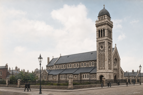
St Mary’s Church stands on Athlunkard Street in Limerick, occupying a site associated with Catholic worship since the eighteenth century. The present church opened in 1932, replacing an earlier chapel where Mass was first celebrated on December 10, 1749. Designed by Ashlin and Coleman of Dublin, the building reflects the scale and ambition of parish church architecture in early twentieth-century Limerick. Its tower, façade, railings and street setting mark an important local landmark, while the surviving holy water font from the former chapel links the modern church with the long religious history of St Mary’s parish community today.

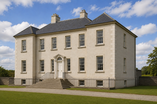
Elm Hill, Co Limerick

Elm Hill, County Limerick, was built around 1790 for the Studdert family as an elegant Georgian country residence. The six-bay, two-storey house stood over a raised basement and contained spacious reception rooms, nine bedrooms, servants’ quarters, kitchens, cellars and service rooms. Following the Great Famine, it was offered for sale and described as being in excellent repair. The property remained substantial for generations but gradually fell vacant and deteriorated. A 2008 architectural survey praised its limestone doorcase, carved timber entrance, slate-hung elevations, fireplaces and decorative plasterwork. Its recognised importance led to designation as a protected structure under Irish planning legislation.

Mathew Bridge, Limerick

Mathew Bridge, completed between 1844 and 1846, forms an important crossing over the Abbey River in Limerick City. Designed by William Henshaw Owen, the triple-span ashlar limestone structure features segmental arches, rounded breakwaters and a broad flat roadway. It linked Rutland Street and Bank Place with Bridge Street and Merchant’s Quay, connecting the Georgian commercial quarter of Newtown Pery with medieval Englishtown. The bridge replaced the inadequate New Bridge of 1762 and accommodated the city’s growing Victorian traffic. Named for Father Theobald Mathew, the celebrated temperance reformer, it remains a notable example of nineteenth-century Irish civic engineering and urban development.

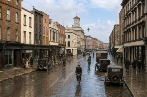
O’Connell Street, 1937

This 1937 view of O’Connell Street, historically known as George’s Street, captures Limerick’s principal commercial thoroughfare during a period of urban transition. Georgian façades, prominent shopfronts and the landmark clock tower frame a busy scene of pedestrians, cyclists, motorcars and public transport. Heavy coats and formal dress reflect everyday life before the Second World War, while traditional businesses line both sides of the street. Several buildings and upper storeys shown here were later altered or demolished during redevelopment. Despite extensive modernisation and pedestrianisation, O’Connell Street remains central to Limerick’s commercial, architectural and social identity within the changing modern city today.

St. Mary’s Cathedral

St. Mary’s Cathedral on King’s Island is Limerick’s oldest continuously used building and one of Ireland’s most important medieval churches. Founded in 1168 by Domnall Mór Ua Briain, it occupies the site of a royal palace and earlier Viking assembly ground. Its Romanesque doorway, fifteenth-century oak misericords and so-called Lepers’ Window preserve remarkable traces of medieval worship. The cathedral’s tower contains eight bells cast in London, while its limestone walls still bear scars associated with the Williamite siege of 1691. Despite periods of occupation, damage and restoration, St. Mary’s remains an active cathedral and enduring symbol of Limerick’s history today.

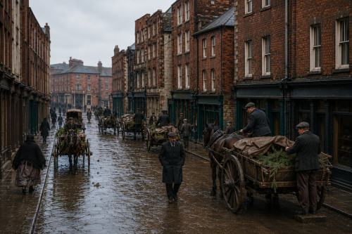
Limerick Market Day, 1937

This photograph, dated 1 March 1937, captures a busy market day in Limerick city. Horse-drawn carts, traders, shoppers, and farmers crowd the wet street, creating a vivid picture of everyday commercial life. On the right, a man drives a horse and trap, a form of transport commonly associated with more prosperous Irish farmers. Market goods are displayed on carts and stalls, while pedestrians move between the buildings lining the street. The scene records the importance of markets to Limerick’s economy, bringing rural producers and urban customers together during a period when horses remained central to transport and trade throughout Ireland.

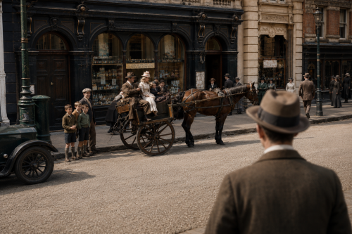
Jaunting Car On O’Connell Street

By 1937, O'Connell Street stood as Limerick's principal commercial thoroughfare, its Victorian and Georgian frontages housing chemists, drapers, and grocers that served the city's daily life. Ireland was still finding its footing after the Economic War with Britain, which had strained trade and agriculture through much of the decade, while the country prepared to adopt a new Constitution that same year. Horse-drawn jaunting cars remained a familiar sight on Limerick's streets even as motor vehicles grew more common, reflecting a city balancing older rhythms of trade and transport with the slow arrival of modern urban life in provincial Ireland.

Blossom Gate, Kilmallock

Blossom Gate is the last surviving medieval gateway of Kilmallock, County Limerick, once one of Ireland’s most strongly fortified towns. Originally one of five entrances through the defensive walls, it alone remains; St John’s, Water, Ivy and Friary gates have disappeared. Standing on Emmet Street, the three-storey stone tower spans the roadway above a pointed arched vault, marking where the town walls formerly joined it. The name may derive from “Blae Gate” or from the Irish word blá, meaning flower or blossom, combined with the French porte, meaning gate. Today, it is a prominent reminder of Kilmallock’s medieval importance and heritage.

Now Sharing: Articles (166) Images (578) Total Items Archived (744)
Our Mission: 100,000 Items Total Percentage Achieved (0.74%)