

Derryvree’s Frozen Garden30236 BCE
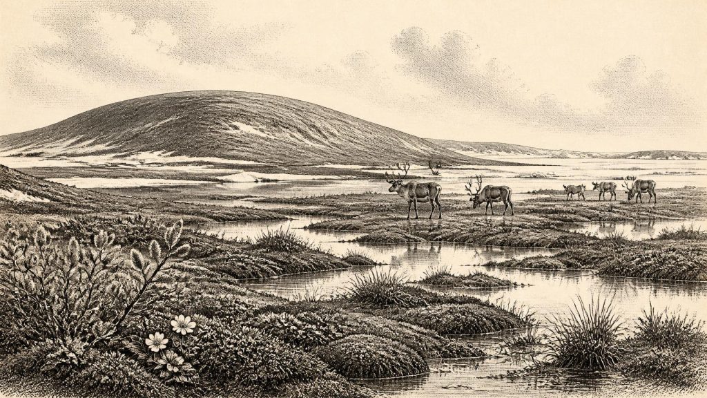
30,236 BCE is a notional filing date rather than a recoverable Irish year. During MIS 3, before the Last Glacial Maximum, Ireland experienced unstable cold conditions, shifting ice margins, altered drainage and low sea levels. At Derryvree, Fermanagh, freshwater sediments beneath glacial till preserve a tundra-like wetland of sedges, grasses, mosses, bogbean and Arctic-alpine plants, formed between ice advances. Castlepook Cave indicates a varied cold-stage fauna, including mammoth, reindeer, giant deer, bear, wolf, fox, hare, lemmings and hyena. A possibly tool-marked reindeer bone suggests fleeting human presence, but no settlement is proven. Ireland’s evidence records environments, wildlife and encroaching ice.
Dateline
The label 30,236 BCE gives a useful filing point, not a recoverable year in Irish history. It falls about 32,185 years before AD 1950, the reference date used for “before present” (BP), within the Late Pleistocene and Marine Isotope Stage 3 (MIS 3). No calendar, written record, annually resolved archaeological layer or known Irish community can be assigned to this notional year. Radiocarbon determinations at this depth have statistical margins and must be calibrated; deposits also form over seasons, centuries or longer. The responsible question is therefore what evidence can illuminate Ireland in the broad climatic interval around it.
The answer is an Ice Age landscape, but not a simple image of an island uniformly entombed beneath ice. Around this horizon, Ireland was moving towards the Last Glacial Maximum, conventionally dated to about 26,500–19,000 calibrated years BP. The maximum ice sheet came later. Evidence from sediments, fossil plants, animal bones and glacial landforms instead indicates unstable conditions in which ice margins, exposed terrain, drainage and animal ranges repeatedly changed. The most vivid Irish environmental witness is a buried freshwater deposit at Derryvree near Maguiresbridge, County Fermanagh.
A Wetland Under the Drumlin
Road works in 1969 cut through a drumlin at Derryvree and revealed fine sands, silts and organic material trapped between two layers of glacial till. Till is sediment deposited directly by glacier ice. The sequence is consequently valuable not because it dates a single moment, but because it records change: an earlier glacial episode, a phase in which freshwater sediments accumulated locally, and a later advance that buried the wetland beneath new till. The upper ice cover helped preserve an otherwise fragile fragment of Ireland’s Middle Midlandian landscape.
The organic horizon produced the conventional radiocarbon determination BIRM-166, 30,500 +1,170/−1,030 radiocarbon years BP. That is not equivalent to 30,500 calendar years ago. Calibration places such a legacy measurement broadly within the mid-to-late 30,000s calibrated BP, with a wide probability range rather than one exact BC date. Its chronological uncertainty means it cannot prove the state of Derryvree in 30,236 BCE itself. Yet it is directly relevant to the same long cold-stage world and demonstrates that, before the later ice advance, this part of Fermanagh contained standing or slow-moving fresh water and ice-free ground.
The fossils describe a cold, open and largely treeless setting. Poorly preserved pollen was supplemented by plant macrofossils and mosses. Sedges and grasses grew around wet margins. Water-milfoil indicates freshwater, while the seed of bogbean (Menyanthes trifoliata) points to shallow water or saturated ground. Mountain avens, dwarf willow and lesser clubmoss support an Arctic-alpine or tundra-like vegetation mosaic. This was not a modern peat bog, nor a featureless snowfield: it was a seasonal patchwork of pools, muddy sedge fringes, mossy ground, sparse herb cover and exposed mineral surfaces.
Interpretation must remain local. Derryvree offers unusually close evidence for one Fermanagh basin and its catchment, not a precise map of every Irish valley. Nor should a few tree-pollen grains be turned into a forest reconstruction; they may have travelled far or been redeposited. What the site securely establishes is that a freshwater ecosystem existed between glacial episodes, in a periglacial climate shaped by severe cold and recurrent freezing and thawing.
An Island in Climatic Motion
MIS 3 was not climatically uniform. North Atlantic records show abrupt shifts between colder stadials and relatively milder interstadials. Irish sequences preserve the consequences of these changes, but are seldom precise enough to correlate a local layer confidently with one named Greenland event. The extent and timing of pre-Last Glacial Maximum ice across Ireland remain active research questions. Some reconstructions suggest that much of the island remained ice-free until roughly 32,000 calibrated BP, while other evidence shows earlier glaciation in particular regions. At the date represented here, an advancing ice sheet was a growing possibility rather than a settled island-wide fact.
Sea level was far lower than today because much water was stored in continental ice sheets. The outlines of Ireland, Britain and the surrounding shelf were therefore radically different. Exposed lowlands and changing marine passages could have affected the movement of animals and, potentially, people. But low sea level alone does not demonstrate a continuous dry route at a particular time, nor does it allow a modern coastline to be projected backwards. The Irish Sea basin was itself influenced by shifting ice, meltwater and marine conditions.
The physical landscape was also transient. Glaciers eroded valleys and deposited till; meltwater reworked sediment; frost broke rock and disturbed soils; and later ice removed or buried much evidence from earlier phases. This destructive history is one reason why Ireland’s record of the deep Palaeolithic is so sparse. Absence of sites cannot automatically be read as absence of animals or people, but neither can it be filled with imagined camps and migrations.
Castlepook’s Animal World
For the broader animal community of pre-maximum Ireland, Castlepook Cave near Doneraile in north County Cork is indispensable. The cave’s deposits and old collections contain remains attributed to woolly mammoth, reindeer, giant deer, brown bear, wolf, Arctic fox, mountain hare, lemmings and spotted or cave hyena. Radiocarbon reassessment shows that parts of the Castlepook fauna belong to MIS 3, while individual bones and layers accumulated at different times. A cave assemblage is therefore not a census of animals standing together on one day, but it firmly shows that Ireland could support, or receive, a diverse cold-stage fauna during this broad period.
Reindeer were suited to open country, and small mammals such as lemmings reinforce the impression of harsh environments. The presence of mammoth and hyena is especially striking, although it should not produce a cinematic reconstruction of an entire island crowded with megafauna. Carnivores may have dragged prey remains into caves; animals died in different places and times; excavation methods in the nineteenth and early twentieth centuries often left limited contextual records. Castlepook is strongest as evidence for a changing regional faunal world, not for the exact ecology of a single calendar year.
Predation, scavenging and competition were certainly parts of that world, but evidence does not permit an account of particular hunts, animal conflicts or population numbers. In human terms, this is a landscape of subsistence potential rather than a documented economy. Reindeer, hares and other animals could have supplied meat, skins, bone and antler to any passing hunters, but there is no securely identified Ice Age settlement, hearth, tool-making floor or storage place in Ireland from which to reconstruct routine life.
The Human Question
Castlepook also raises the most consequential, and most limited, question about people. A reindeer femur from the cave has been publicly reported as about 33,000 years old and as bearing an incision interpreted by zooarchaeologist Ruth Carden as damage made by a sharp stone tool during butchery. If that interpretation is confirmed, it would be potentially the earliest evidence of human activity in Ireland: an episode in which someone processed a reindeer long before the well-attested Mesolithic settlement of the island.
Potentially is essential. The bone comes from an old collection rather than a newly excavated occupation surface containing associated tools, hearths and dated sediments. A date on the bone establishes the animal’s age, not automatically the date or agency of every mark on it. Cut-mark identification must distinguish human action from carnivore damage, sediment abrasion, trampling, breakage and excavation damage. One modified specimen, even if human-made, would show a visit or act of carcass processing; it would not establish a permanent population, named group, family, camp, sea crossing or descent from later Irish communities.
For that reason, political affairs, diplomacy and warfare cannot responsibly be supplied for Ireland around 30,236 BCE. There are no polities, leaders, boundaries, weapons assemblages or conflict sites. Nor is there evidence for religion, formal burial, art, language, teaching, exchange networks or trade. The absence of evidence is not proof that visitors had no beliefs, skills or social relationships; Upper Palaeolithic peoples elsewhere in Europe possessed rich cultural traditions. It does mean that these cannot be assigned to Ireland without direct Irish evidence.
What Can Be Said
The most supportable picture is therefore environmental rather than biographical. Around the thirty-first millennium BCE, Ireland lay in a changing north-west European Ice Age zone. At Derryvree, a cold freshwater wetland had formed during an interval between ice advances, supporting hardy tundra and wetland plants. Elsewhere, particularly in the evidence from Castlepook, mammoth, reindeer and predators belonged to a wider fauna whose movements depended on shifting terrain and climate. A possible humanly modified reindeer bone makes brief human presence conceivable, perhaps even likely, but not yet demonstrably settled.
This was not yet the familiar human Ireland of farms, monuments, territories or written memory. Its history survives instead in a bogbean seed, mosses and silts beneath a drumlin; in cave bones; and in the immense geological force of ice that both erased and preserved the record. The central development was not a battle or a ruler’s accession, but the unstable relationship between fresh water, open ground, wildlife and encroaching glacier ice.
Primary Sources
- A Middle Midlandian Freshwater Series at Derryvree, Maguirebridge, County Fermanagh, Northern Ireland
- Figure 6.— The Subdivision of the Quaternary Period in Ireland
- The Irish Quaternary Fauna Project
- A Reconsideration of the Radiocarbon Dating of the Marine Isotope Stage 3 Fauna from Southern Ireland
- First Evidence of a Late Upper Palaeolithic Human Presence in Ireland
- First Evidence of a Late Upper Palaeolithic Human Presence in Ireland
- New Insights on the Fauna of Ireland's Younger Dryas and Early Holocene from Alice & Gwendoline Cave
- The Timing and Magnitude of the British–Irish Ice Sheet Between Marine Isotope Stages 5d and 2
- Pattern and Timing of Retreat of the Last British-Irish Ice Sheet
- Timing and Pace of Ice-Sheet Withdrawal Across the Marine–Terrestrial Transition West of Ireland During the Last Glaciation
- The Deglaciation of the Western Sector of the Irish Ice Sheet from the Inner Continental Shelf to its Terrestrial Margin
- Dimensions and Chronology of the Last Ice Sheet in Western Ireland
- Stratigraphic and Palaeo-Geomorphological Evidence for the Glacial-Deglacial History of the Last British-Irish Ice Sheet in the North-Western Irish Sea
- Anthropogenic Changes to the Holocene Nitrogen Cycle in Ireland
- Prehistoric Details
- Ireland's Palaeolithic Archaeology – Fleeting Footprints in a Frozen Land
- Menyanthes trifoliata
- Dryas octopetala
- Occurrence of Mammalia Relicts at Site Castlepook Cave
- IAH Field Trip 2014





