
Juniper Beneath Derryvree30693 BCE
Thirty-thousand six-hundred and ninety-three BCE cannot be resolved archaeologically, but Derryvree, County Fermanagh, provides evidence overlapping this period. Freshwater organic sediments between glacial tills indicate a temporary ice-free wetland within volatile MIS 3 conditions, supporting tundra-like vegetation, mosses, sedges, juniper and aquatic plants rather than forest. Castlepook Cave, County Cork, preserves a long-accumulated fauna including mammoth, reindeer, giant deer, predators and lemmings, demonstrating intermittent ecological connections with Europe. A possibly cut-marked reindeer bone suggests, but does not prove, early human visits. No settlements, societies or political structures are evidenced. Together, these archives reveal cold, open, changing landscapes before renewed glaciation.
Dateline
30,693 BCE is a modern calendar label, not a year that can be observed at archaeological resolution. No Irish deposit can identify an event, person, journey or season in that precise year. It falls within the Late Pleistocene, during Marine Isotope Stage 3 (MIS 3), a long and climatically volatile part of the last glacial cycle. The safest approach is therefore to examine evidence whose calibrated ranges overlap this point, while keeping the distinction between dated material, environmental reconstruction and historical interpretation firmly in view.
The most relevant Irish archive is Derryvree, near Maguiresbridge in County Fermanagh. Road works in 1969 cut through a drumlin and revealed freshwater silts and fine sands sandwiched between two layers of glacial till. The organic sediments produced the radiocarbon determination BIRM-166, 30,500 radiocarbon years BP, with a substantial uncertainty of +1,170/−1,030 years. Radiocarbon years are not calendar years: atmospheric carbon-14 has varied through time. Published calibration places the date broadly at c. 36,900–31,700 calibrated years BP, approximately 34,950–29,750 BCE. That range includes 30,693 BCE, but it does not mean that the deposit records conditions on that particular year.
A Wetland Between Ice Advances
Derryvree’s importance lies in its stratigraphy. Till below the freshwater beds shows that glacier ice had previously affected the locality. The silts and organic material demonstrate that, for a time, the place was free of overriding ice and able to sustain standing or slow-moving fresh water, wet ground and living vegetation. Till above the deposit records renewed glacial activity or ice-proximal deposition that eventually buried and protected this short-lived archive. It is an unusually vivid survival from a landscape otherwise repeatedly eroded, frozen and remodelled during the Ice Age.
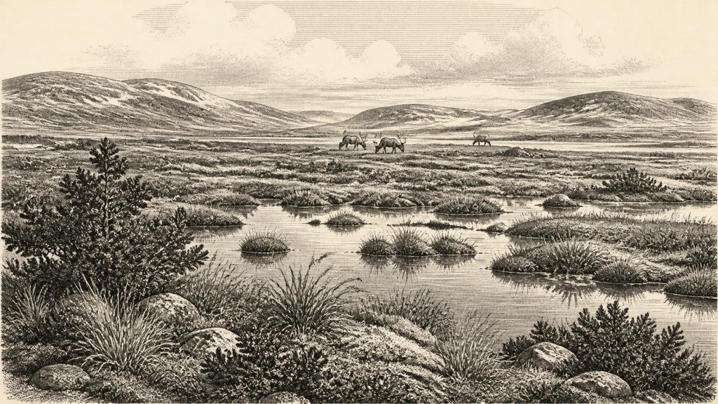
The resulting landscape should not be imagined as either a permanent white wilderness or a familiar wooded Ireland. Pollen, plant macrofossils, mosses and insects indicate open, cold-country vegetation. Grasses, sedges, herbs, juniper and cold-adapted mosses are the strongest signals. The fossil assemblage has been interpreted as tundra or muskeg-like terrain: waterlogged, mossy and sedgy ground with shallow pools, patches of exposed mineral soil and scant shelter from wind. A few pollen grains from trees such as pine or hazel cannot demonstrate local forest, since pollen may travel far and can be redeposited. The wider evidence instead supports a largely treeless environment.
Fresh water was a crucial feature of this severe setting. The Derryvree deposits include plants associated with wet margins and pools, among them bogbean and water-milfoil, alongside a rich moss flora. Such remains do not create a postcard-sized reconstruction of the whole island. They record a particular basin, accumulated over an interval rather than in an instant. Yet they establish something important: north-east Fermanagh could support biologically productive wetland habitats during part of MIS 3, despite cold winters, frost action and a generally periglacial climate.
Cold Country, Changing Quickly
At this horizon Ireland was part of the north-western edge of Europe’s changing glacial world. Sea levels were far lower than today because vast quantities of water were held in continental ice sheets, and the outlines of coastlines and shallow seas differed greatly from modern maps. But the exact availability of a dry route into Ireland at 30,693 BCE cannot be safely reconstructed from Irish evidence alone. Ecological connections with Britain and continental Europe are demonstrated by the arrival of mammals at different times; a specific land bridge, crossing route or date of human travel is not.
MIS 3 was not climatically uniform. Greenland ice-core records show repeated abrupt shifts, while Irish terrestrial sequences are fragmentary and difficult to correlate exactly with them. The Derryvree radiocarbon range has been related broadly to Greenland Interstadials 8 to 5, but that correlation is necessarily approximate. What matters for Ireland is the local result: cold, open ground and fresh water existed between episodes of glacial deposition. In the following millennia the last British–Irish Ice Sheet enlarged dramatically, though its advance, maximum extent and retreat were asynchronous in different sectors. Later ice both transformed the land and removed much of the evidence for the landscapes that preceded it.
Castlepook’s Animal Archive
Nearly 300 kilometres to the south, Castlepook Cave near Doneraile in County Cork provides the principal Irish faunal counterpart to Derryvree. Also known as Mammoth Cave, its limestone passages yielded thousands of animal remains during antiquarian excavations in the early twentieth century. The cave is Ireland’s richest known repository of vertebrate evidence from before the Last Glacial Maximum. Direct dates and reappraisal of its collections show that its material accumulated over a long span, rather than representing one moment or one intact occupation floor.
Its fauna includes woolly mammoth, reindeer, giant deer, brown bear, wolf, Arctic fox, lemmings and spotted hyaena. This combination indicates that Ireland was, at least intermittently, accessible to a much broader Pleistocene mammal community than survives on the island today. Reindeer and lemmings are consistent with cold open environments; mammoth and giant deer underline the scale and variety of herbivore life. Spotted hyaena is particularly significant. A cave rich in bones is not automatically a hunters’ camp: carnivores, natural deaths, water movement, cave entrances and the practices of early excavators all helped create the assemblage. Castlepook therefore documents an ecosystem and complex bone history, not a neatly preserved scene.
The cave offers a cautious window onto food webs. Herbivores drew nourishment from the sparse but productive seasonal vegetation of open ground and wetland margins. Predators and scavengers, including wolves and hyaenas, could exploit living prey and carcasses. Caves provided shelter or denning opportunities and acted as traps or repositories for bones. There is no basis, however, for assigning particular species to Derryvree in 30,693 BCE, or for claiming that all animals from Castlepook lived together at the same time. The Irish Pleistocene record is powerful precisely because it is so rare, but its rarity makes chronological precision essential.
The Human Question
A reindeer femur from Castlepook has brought the possibility of a much older Irish human presence into focus. Ruth Carden identified a deep surface mark interpreted as damage made by a sharp stone implement while the bone was fresh, potentially during carcass processing. The bone has been widely presented as evidence that people may have reached Ireland around 33,000 years ago. If sustained by continuing research, that interpretation would be of major significance for the Irish Upper Palaeolithic.
It cannot, however, demonstrate a settled population in 30,693 BCE. The object comes from an old cave collection rather than a sealed excavation context containing a hearth, tool assemblage, dwelling surface, repeated butchery debris or human remains. Dating the animal establishes the age of the bone within a range, not an exact date for the mark. No securely dated Irish settlement, house, grave, art panel, ornament or lithic industry is presently known from this horizon. Human presence is best described as possible and under investigation, rather than as an established national beginning.
If visitors did reach Ireland, comparison with Upper Palaeolithic groups elsewhere in north-west Europe makes short-term, mobile foraging a reasonable hypothesis. Reindeer could supply meat, marrow, hide, sinew, antler and bone, and sheltered limestone country might have been useful in harsh weather. But this is contextual interpretation, not a demonstrated description of an Irish community. There is no direct evidence here for named peoples, language, kinship systems, chiefs, territories, warfare, diplomacy, trade, ritual or formal learning. Nor can modern ethnic labels be projected into a period tens of millennia before later Irish identities.
No Politics, but a Living Landscape
For this reason, political history has no proper place in an account of Ireland at this date. There were no recorded polities, borders, rulers or diplomatic relations, and the archaeological evidence does not permit substitutes to be invented. Likewise, religion and culture cannot responsibly be inferred from caves merely because caves acquired ritual meanings in much later periods. There is no Irish shrine, burial practice, artwork or symbolic object securely attributable to this horizon.
The economy visible at Derryvree and Castlepook is first an ecological one: plants colonising wet ground, herbivores moving through open country, carnivores using prey and carrion, water carrying sediment, and ice repeatedly altering access to land. Any human economy remains hypothetical, limited to the possibility that one or more people processed animal carcasses. The central regional development was environmental instability. An island landscape that could contain local ice-free wetlands and diverse mammal habitats was moving towards the more extensive glaciation of the Last Glacial Maximum.
What survives from around 30,693 BCE is therefore neither a year’s chronicle nor a lost Irish kingdom. It is a set of fragile scientific traces: freshwater silt beneath a Fermanagh drumlin, pollen and mosses from cold wet ground, and bones from a Cork cave whose history mixes animals, carnivores, water and excavation. Together they show an Ireland that was cold, open, ecologically connected at intervals to a wider European world, and subject to profound change. They also show the value of restraint: evidence can illuminate the conditions of deep time without pretending to recover a calendar year that the record cannot see.
Primary Sources
- A Middle Midlandian Freshwater Series at Derryvree, Maguiresbridge, County Fermanagh, Northern Ireland
- Palaeoecology
- Landscapes and Environments of the Last Glacial-Interglacial Transition: A Time of Amazingly Rapid Change in Ireland
- The Geology of Ireland: Cenozoic—Tertiary and Quaternary
- The Irish Quaternary Fauna Project
- A Reconsideration of the Radiocarbon Dating of the Marine Isotope Stage 3 Fauna from Southern Ireland
- Castlepook Cave: County Geological Site Report
- 2022:564 – Castlepook Cave, Castlepook South, Cork
- Archaeology Research Excavation Grant 2022: Castlepook Cave Project Report
- New Insights on the Fauna of Ireland's Younger Dryas and Early Holocene from Alice & Gwendoline Cave
- Occurrence of Mammalia Relicts at Site Castlepook Cave
- The Archaeology of Caves in Ireland
- Mammoth Cave
- Quaternary Site Descriptions
- Quaternary Data and Maps
- Growth and Retreat of the Last British–Irish Ice Sheet, 31,000 to 15,000 Years Ago: the BRITICE-CHRONO Reconstruction
- Trimlines, Blockfields and the Vertical Extent of the Last Ice Sheet in Southern Ireland
- Response of the Irish Ice Sheet to Abrupt Climate Change During the Last Deglaciation
- Timing and Pace of Ice-Sheet Withdrawal Across the Marine–Terrestrial Transition West of Ireland During the Last Glaciation
- Dimensions and Chronology of the Last Ice Sheet in Western Ireland
- Revealing the Past 2023: In Search of the Elusive Palaeolithic in Ireland
- Autumn 2023 Newsletter