
Derryvree’s Periglacial Flora30292 BCE
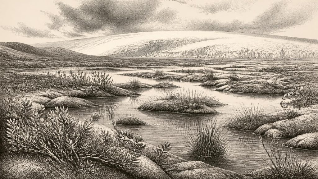
Around 30,292 BCE, Ireland lay in a cold, unstable Marine Isotope Stage 3 environment. At Derryvree, County Fermanagh, freshwater organic sediments between glacial tills record an ice-free interval before renewed advance. Pollen, plants, mosses, insects and animal remains indicate open, treeless periglacial wetland, with pools, sedges, sparse vegetation and frost-affected ground. Castlepook Cave, County Cork, preserves pre-Last Glacial Maximum fauna including mammoth, reindeer, giant deer, hyaena and lemmings, though cave deposits are time-mixed. A cut-marked reindeer femur may indicate human carcass processing, but cannot prove settlement. No evidence identifies contemporary society, institutions or permanent occupation; environmental change is the record.
Dateline
30,292 BCE is a modern label for a point deep in the Late Pleistocene, not a year that anyone in Ireland could have named, recorded or remembered. Calendar-year precision is not available at this depth of time. The most useful comparison is the radiocarbon-dated freshwater deposit at Derryvree, near Maguiresbridge in County Fermanagh: its conventional age of 30,500 +1,170/−1,030 radiocarbon years BP has been expressed in published calibrations as a broad range of roughly 36,900–31,700 calibrated years BP. The notional year 30,292 BCE lies within that wide interval, but cannot be tied to a particular season, animal, human action or sediment layer. What can responsibly be described is an archaeological and environmental phase: a cold, unstable part of Marine Isotope Stage 3, before the fullest expansion of the last British–Irish Ice Sheet.
A Freshwater Interval Between Ice Advances
Derryvree is important because of its physical sequence. Roadworks in 1969 cut through a drumlin and exposed two thick layers of glacial till, with freshwater silts, fine sands and organic material trapped between them. Till is debris deposited directly by glacier ice. The strata therefore establish a clear order of events at this one Fermanagh locality: ice had covered the ground; an ice-free interval followed in which water, sediment and organic remains accumulated; then a later advance buried and preserved the deposit beneath fresh till. This is compelling evidence for changing local conditions, not a complete map of Ireland or a date for an event in 30,292 BCE.
The deposits produced pollen, plant macrofossils, moss remains and insects, as well as small animal evidence. Taken together, these indicate a cold, open and largely treeless setting, traditionally described as tundra or a muskeg-like wetland. Such terms should be used as ecological shorthand rather than as exact modern equivalents. Derryvree contained shallow or slow-moving freshwater and wet margins, while nearby ground was exposed to severe frost and seasonal thaw. The evidence rules out the familiar later Irish landscape of broadleaf woodland, enclosed fields and settled farmsteads. It instead reveals a patchwork of pools, sedges, mossy ground and sparse cold-adapted vegetation.
Plants in a Severe Landscape
The plant evidence is particularly valuable because it shows that a cold Ireland was not simply a lifeless expanse of ice. Grasses, sedges and herbs were present, alongside mosses. Recorded macrofossils include wetland and cold-tolerant plants such as bogbean, water-milfoil, dwarf willow, juniper, mountain avens and lesser clubmoss. Their precise distributions around the ancient basin cannot be reconstructed, nor can every taxon be assumed to have grown at the same moment. Yet their combination supports a landscape where open water, saturated margins and dry, frost-affected ground stood close together.
This was a periglacial environment: one shaped by the climate and processes of a region close to glacier ice, whether or not a particular patch of land was actually ice-covered at a given time. Long, severe winters would have restricted plant growth; short summers permitted a limited growing season. Freeze–thaw action disturbed soils and altered drainage. The low vegetation would have left wide sightlines across the terrain, but it offered little shelter. Derryvree’s organic bed is consequently a rare witness to life in an interval of local openness between glacial episodes, not evidence that Fermanagh enjoyed a stable or mild refuge for millennia.
Ireland Before the Ice Sheet’s Maximum
At this horizon, the last glacial cycle was dynamic rather than uniform. The ice sheet that later covered much of Ireland was growing and reorganising over thousands of years, with different margins advancing and retreating at different times. Large-scale reconstructions of the British–Irish Ice Sheet place its maximum overall extent later, around 26,000 years ago, while showing that growth and decay varied greatly from one sector to another. Derryvree’s inter-till record fits this broader picture of a landscape repeatedly transformed by ice, water and changing climate.
Sea level was substantially lower than today because vast quantities of water were held in continental ice sheets. Coastlines and shallow seas around Ireland were therefore different, but it would be unsafe to turn that fact into a simple claim of a reliable land route from Britain or continental Europe at this exact time. Ice margins, marine channels, rivers, exposed shelves and local topography changed through the period. For animals and any people who may have entered the region, movement depended on a shifting combination of terrain, weather, available food and barriers of water or ice. The geography of access was part of the environmental uncertainty.
Animals Recorded in Southern Caves
Irish caves provide another, geographically separate line of evidence. Castlepook Cave near Doneraile in north County Cork has yielded remains of woolly mammoth, reindeer, giant deer, spotted hyaena, wolf, fox, hare and lemmings. These bones do not describe a single living animal community gathered on one day. Cave assemblages may be time-mixed, and carnivores, water movement, excavation methods and later disturbance can all affect what survives. Improved radiocarbon pretreatment has also shown that some older Irish cave dates need revision. Nevertheless, re-dating confirms that Castlepook preserves evidence for a notably older, pre-Last Glacial Maximum fauna during Marine Isotope Stage 3.
The wider implication is measured but significant. Large grazers and predators could reach, occupy or at least pass through parts of Ireland during suitable phases of the late Ice Age. Reindeer are well suited to open, cold landscapes; lemmings and Arctic fox similarly point towards northern or continental conditions unlike those of modern Ireland. Mammoth and hyaena remains underline that the island’s Pleistocene fauna was once much richer and stranger than its later historic fauna. Yet Castlepook should not be treated as a census of all Ireland. It records the accumulated history of a limestone cave and its catchment, not a national wildlife survey.
The Reindeer Femur Question
The most tantalising possible human evidence for this broad era is a reindeer femur from Castlepook bearing a mark interpreted by zooarchaeologist Ruth Carden as a cut made with a sharp stone tool during carcass processing. Public heritage accounts place the bone at about 31,000 BCE, close enough to the Derryvree chronological window to make it relevant to 30,292 BCE. If the mark is anthropogenic, it would show that people used a sharp implement on a reindeer carcass in Ireland during the Upper Palaeolithic. Possible purposes include removing meat, hide or sinew, but the bone alone cannot distinguish between them.
Its limits matter as much as its promise. The specimen derives from an old cave collection rather than a newly excavated, sealed occupation floor with tools, hearths, refitting debris and clearly associated food remains. Recent work at Castlepook has identified surviving cave sediments but did not recover cultural artefacts in its 2022 excavations. A marked bone may therefore indicate a brief encounter, hunting-related processing or the movement of an already processed carcass part; it cannot establish a permanent settlement, population size, seasonal camp or continuous occupation. The reindeer femur is best understood as an important research problem and a possible early trace of people, rather than the foundation for a populated national narrative.
What Society Cannot Yet Be Seen
No Irish evidence securely assigns political institutions, leaders, territories, diplomacy or organised conflict to this date. There are no known houses, hearths, burials, stone-tool assemblages, art panels or written records from Ireland that can be placed specifically in 30,292 BCE. Accordingly, there is no responsible basis for describing clans, languages, religious rites, learning, trade networks or gendered work in Irish society at this moment. The absence is not proof that no person ever crossed the landmass; it is a statement about the present archaeological record and its capacity to answer historical questions.
Even economy can be approached only narrowly. If the Castlepook mark was made by people, it may reflect the procurement or processing of a large game animal, an activity familiar among Upper Palaeolithic hunter-gatherers elsewhere in Europe. It does not demonstrate that such people lived permanently in Ireland, controlled a territory or exchanged goods across it. Nor should the rich cave fauna be made to imply an abundant, predictable larder: predators, harsh seasonality and rapidly changing ice conditions made survival precarious. There is no direct evidence for agriculture, animal husbandry, pottery, metalworking, long-distance commerce or monument building.
A History Written in Deposits
The principal development illuminated around 30,292 BCE is environmental change. Derryvree records a cold freshwater wetland and open vegetation established after one glacial episode and before another. Castlepook shows that Ice Age mammals formed part of the broader Irish story during the same general climatic stage, while the debated reindeer femur raises the possibility of an exceptionally early human visit. The next millennia would bring more extensive glaciation, scouring or burying many earlier landscapes and helping to explain the fragmentary record.
This is therefore not a year of named rulers or events, but a period in which Ireland’s future terrain was being made under intense climatic pressure. Mosses, sedges and aquatic plants at Derryvree; bones accumulated in a Cork cave; and the tills that eventually sealed or displaced their contexts are the surviving archive. Their evidence is limited, local and sometimes contested. Precisely for that reason, it offers the most reliable account available: a changeable, largely treeless late-Ice-Age Ireland, intermittently habitable for cold-adapted life and not yet historically legible as a settled human country.
Primary Sources
- A Middle Midlandian Freshwater Series at Derryvree, Maguiresbridge, County Fermanagh, Northern Ireland
- A reconsideration of the radiocarbon dating of the Marine Isotope Stage 3 fauna from southern Ireland
- The Irish Quaternary Fauna Project
- Trimlines, blockfields and the vertical extent of the last ice sheet in southern Ireland
- Growth and retreat of the last British–Irish Ice Sheet, 31,000 to 15,000 years ago: the BRITICE-CHRONO reconstruction
- The IntCal20 Northern Hemisphere radiocarbon age calibration curve (0–55 cal kBP)
- New insights on the fauna of Ireland’s Younger Dryas and Early Holocene from Alice & Gwendoline Cave
- Character of advance and retreat of the southwest sector of the British-Irish Ice Sheet during the last glaciation
- Irish Pleistocene biostratigraphy
- Palaeoecology
- Figure 6.— The subdivision of the Quaternary Period in Ireland
- The Geological Heritage of County Leitrim
- ESCR Site Summary
- Introduction to the Glacial Sand and Gravel Landscapes of Northern Ireland
- 2022:564 — Castlepook Cave, Castlepook South, Cork
- Heritage Artefacts of County Cork
- Preliminary Assessment of the Archive of Faunal Remains from Excavated Irish Cave Sites
- Radiocarbon, Vol. 16, No. 1 (1974), pp. 6–9
- Growth and Retreat of the Last British–Irish Ice Sheet, 31,000 to 15,000 Years Ago: the BRITICE-CHRONO Reconstruction
- Exploring Controls of the Early and Stepped Deglaciation on the Western Margin of the British-Irish Ice Sheet
- A Critical Review and Re-investigation of the Pleistocene Deposits
- New Insights on the Fauna of Ireland’s Younger Dryas and Early Holocene from Alice & Gwendoline Cave
