

Derryvree’s Sub-Till Landscape30291 BCE
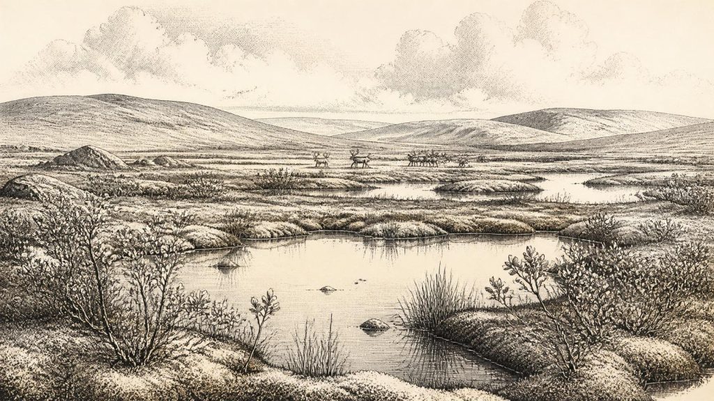
30,291 BCE is a modern label rather than a recoverable Irish historical year. At Derryvree, County Fermanagh, freshwater silts and organic deposits between glacial tills indicate a cold, open, tundra-like wetland during a broad MIS 3 interval, although radiocarbon calibration cannot date a precise moment. Plants included sedges, grasses, mosses, dwarf willow and aquatic species. Cave fauna elsewhere, notably Castlepook, records mammoth, reindeer, giant deer and predators, but not a contemporaneous census. Climatic shifts preceded later ice-sheet expansion, which destroyed or buried evidence. No secure human occupation is known; a possibly cut-marked reindeer bone offers only tentative Upper Palaeolithic evidence.
Dateline
A Date Beyond Annual History
“30,291 BCE” is a modern calendar label, not a year that can be recovered from Ireland’s prehistoric record. No contemporary people in Ireland counted years in this way, and the available evidence cannot identify an event, a settlement episode or a particular season in that single year. At most, the label falls within a broad late-Pleistocene interval reconstructed from deposits, fossils and climate archives. It is therefore more responsible to describe the changing conditions that may illuminate this point than to manufacture an annual chronicle.
The closest important chronological anchor is Derryvree, near Maguiresbridge in County Fermanagh. During roadworks in 1969, a cut through a drumlin exposed freshwater silts and fine sands, including organic material, between two distinct sheets of glacial till. The original radiocarbon determination, BIRM-166, was 30,500 radiocarbon years before present, with a substantial uncertainty. Subsequent calibration places it broadly at c. 36,900–31,700 calibrated years BP, approximately 34,950–29,750 BCE. The conventional date of 30,291 BCE lies within that wide range, but it cannot be assigned to a particular layer or moment within the deposit.
That distinction is crucial. Radiocarbon years are not calendar years: atmospheric carbon-14 has varied through time, and calibration at this depth in the past produces broad probability ranges rather than a pinpoint date. Nor did the Derryvree sediments necessarily accumulate in a single uninterrupted spell. Their value lies chiefly in their sequence. Earlier ice laid down the lower till; freshwater, plants and animals then occupied a local basin; later ice deposited the upper till, sealing the evidence beneath the drumlin. Relative order is secure. Exact timing, duration and the relationship of this Fermanagh wetland to every other Irish region are much less certain.
Freshwater Between Ice Advances
Derryvree provides unusually vivid evidence that Ireland was not simply a featureless white expanse throughout the later Ice Age. Its fossil assemblage indicates an open, cold and largely treeless landscape around shallow freshwater. Sedges, grasses, mosses, dwarf willow, juniper, herbs and aquatic plants were recorded from the organic layers. Bogbean and alternate water-milfoil point to standing or slowly moving water, while other remains suggest wet ground, shallow pools and marshy margins. This was a tundra-like environment, shaped by severe winters and short growing seasons, rather than the wooded island familiar from later prehistory.
It would nevertheless be wrong to turn one buried basin into a map of all Ireland. Derryvree was a local refuge of water and sediment accumulation within a broader, varied country of slopes, valleys, uplands and coasts. Plant remains tell us what grew near that wetland, not precisely what lay across every plain. Yet the evidence does establish an important corrective: even in a cold stage, habitats could be diverse at a small scale. Open mineral ground, sedge beds, mossy edges and pools would have offered different niches to insects, small mammals and larger grazing animals.
The wider climatic setting was Marine Isotope Stage 3, an unstable part of the last glacial cycle. Ireland experienced sharp shifts between relatively milder interstadial conditions and renewed cold. Speleothems from Crag Cave in County Kerry add an independent line of evidence. Calcite can grow only when liquid water moves through the cave system and temperatures above ground are sufficiently favourable; uranium-thorium dating shows that growth occurred episodically during warmer intervals of the last glacial period. Such evidence does not date Derryvree itself, but it confirms that Ireland’s climate was not static. Conditions could change substantially over millennia, and sometimes more rapidly, well beyond the resolution available for a calendar year.
Fauna at the Atlantic Edge
The animal record from southern Irish caves gives this landscape living scale. Castlepook Cave, near Doneraile in north County Cork, has yielded Ireland’s most notable pre-Last Glacial Maximum fauna: woolly mammoth, reindeer, giant deer, brown bear, wolf, Arctic fox, lemmings and spotted hyena. The National Museum of Ireland holds an incomplete hyena skull from the cave, and revised radiocarbon work has shown that parts of the cave assemblage are older than early dating programmes suggested. The fauna demonstrates that, at different points in the wider Middle Midlandian interval, Ireland could support a markedly continental-looking community of large grazers, browsers, scavengers and predators.
These fossils should not be treated as a census for 30,291 BCE. Cave deposits are often accumulated over long periods and can be affected by animal activity, excavation history and later disturbance. A hyena bone establishes the species’ presence at a site during an appropriately dated interval; it does not show a permanent hyena clan at every Irish cave, nor prove that mammoths and reindeer all occupied one locality at the same time. Revised dating has, if anything, made caution more necessary. It has also made the evidence more valuable, by indicating that some species were present in Ireland well before the coldest phase of the Last Glacial Maximum.
At Castlepook, caves themselves may have been important landscape features. Carnivores could use them as dens or feeding places; bones might enter through predation, scavenging, natural death or water movement. In the open country beyond, reindeer and mammoth imply vegetation capable of sustaining large herbivores, although their movements may have been seasonal and their ranges extensive. Predators and scavengers would have followed those resources. This is ecology, not a recovered social history, but it is the closest responsible approach to everyday life on the island at this date: animal movement through a harsh, open and fluctuating environment.
Ice, Sea and Changing Connections
The Derryvree sequence belongs to the period before the fullest known expansion of the last British–Irish Ice Sheet. Modern reconstructions indicate that ice growth and maximum extent were asynchronous around Ireland and Britain, rather than a single island-wide advance on one date. The later Last Glacial Maximum is generally placed around 26,500–19,000 years ago, while ice margins in particular marine sectors reached their greatest extent at different times. Evidence from Derryvree and Greenagho in Fermanagh indicates that north-central Ireland retained ice-free ground until at least the later part of MIS 3, before expanding ice overrode many older surfaces.
That later glaciation explains much of the frustrating scarcity of early evidence. Moving ice eroded bedrock and sediment, altered drainage, redeposited material and buried older landscapes under till. It may have removed camps, hearths or animal-kill places that once existed; equally, their absence may reflect a genuine lack of repeated human settlement. Archaeology cannot select confidently between those possibilities. The surviving record is biased towards caves, waterlogged pockets beneath glacial sediment, and objects that endured transport or burial.
Lower sea levels changed the shape of the surrounding world, but they did not automatically create an easy land route or a settled migration corridor. Ireland’s relation to Britain and the continent was conditioned by sea level, shifting ice, exposed shelves and difficult cold-climate terrain. The presence of Irish cave fauna comparable with that of Britain and continental north-west Europe shows that animals reached the island during suitable phases. It does not show exactly how, how often, or whether humans travelled alongside them. Mobility across this Atlantic-edge landscape was possible at some times and obstructed at others.
People: A Possibility, Not a Polity
No securely excavated house, hearth, burial, stone-tool assemblage, artwork or human skeleton can be placed at 30,291 BCE in Ireland. Accordingly, there can be no evidence-based account of political authority, warfare, diplomacy, kin groups, religious practice, learning, trade or permanent settlement. There were no known Irish kingdoms, communities or institutions to describe. Applying such categories would create a false impression of knowledge and of continuity with later prehistoric Ireland.
One find deserves careful notice without being overstated. A reindeer femur from Castlepook bears a deep mark interpreted by zooarchaeologist Ruth Carden as damage consistent with cutting or chopping by a sharp stone tool; it has been publicly associated with an age of about 33,000 years ago. If that interpretation and chronology are sustained, it would indicate a human encounter with a reindeer carcass in Ireland during the Upper Palaeolithic. It would not demonstrate a village, a population of known size, routine occupation or direct relevance to the exact calendar label used here. The bone is compelling evidence under examination, not permission to invent an Irish Palaeolithic society.
The most defensible conclusion is therefore environmental. Around the broad span into which 30,291 BCE falls, parts of Ireland contained cold, open, locally wet landscapes, with freshwater basins preserved between episodes of glaciation. Large mammals and carnivores occurred on the island during the wider period, while the climate was increasingly heading towards more extensive ice-sheet growth. Derryvree’s buried silts preserve a narrow, remarkable window onto that world: not a dated year of human affairs, but evidence that water, plants and animals persisted in an Ireland later transformed and partly erased by ice.
Primary Sources
- A Middle Midlandian Freshwater Series at Derryvree, Maguiresbridge, County Fermanagh, Northern Ireland
- Trimlines, Blockfields and the Vertical Extent of the Last Ice Sheet in Southern Ireland
- A Reconsideration of the Radiocarbon Dating of the Marine Isotope Stage 3 Fauna from Southern Ireland
- Spotted Hyena Skull
- Growth and Retreat of the Last British–Irish Ice Sheet, 31,000 to 15,000 Years Ago: the BRITICE-CHRONO Reconstruction
- The Timing and Magnitude of the British–Irish Ice Sheet Between Marine Isotope Stages 5d and 2
- Timing and Pace of Ice-Sheet Withdrawal Across the Marine–Terrestrial Transition West of Ireland During the Last Glaciation
- The Deglaciation of the Western Sector of the Irish Ice Sheet from the Inner Continental Shelf to its Terrestrial Margin
- Dimensions and Chronology of the Last Ice Sheet in Western Ireland
- Radiocarbon Constraints on the Age of the Maximum Advance of the British–Irish Ice Sheet in the Celtic Sea
- Late Pleistocene Chronostratigraphy and Ice Sheet Limits, Southern Ireland
- Pleistocene Glaciations in Ireland
- The Irish Quaternary Fauna Project
- First Evidence of a Late Upper Palaeolithic Human Presence in Ireland
- New Insights on the Fauna of Ireland’s Younger Dryas and Early Holocene from Alice & Gwendoline Cave
- Episodic Speleothem Deposition Tracks the Terrestrial Impact of Millennial-Scale Last Glacial Climate Variability in SW Ireland
- Spatio-Temporal Dynamics of Speleothem Growth and Glaciation in the British Isles
- The IntCal20 Northern Hemisphere Radiocarbon Age Calibration Curve (0–55 cal kBP)
- Ireland: Submerged Prehistoric Sites and Landscapes
- The Dungarvan Valley Caves Project: First Interim Report
- Ice Age Ireland





