

The Greenagh Lake Record30211 BCE
At 30,211 BCE, Ireland has no identifiable historical event; the date denotes a broad, uncertain Pleistocene interval. Derryvree, County Fermanagh, preserves freshwater silts between glacial tills, dated approximately 36,900–31,700 calendar years before present. Plant, moss and insect remains indicate a cold, open, largely treeless wetland with shallow water and tundra-like vegetation. The deposit records respite between ice advances during Marine Isotope Stage 3, before maximum ice-sheet extent. Castlepook Cave, County Cork, yielded Ice Age fauna and a possibly cut-marked reindeer bone, suggesting but not proving early human visitation. Evidence establishes changing environments and animals, not settlement, institutions, or named people.
Dateline
30,211 BCE is not a date at which Irish archaeology can identify an event, ruler, battle or calendar day. It is a modern chronological label, projected backwards into a period without writing, local calendars or a continuously dated human record. In archaeological terms it falls roughly 32,160 years before AD 1950, the conventional “present” used for radiocarbon dating. That apparent precision is misleading. The evidence for Ireland at this depth is dated in broad radiocarbon and calibrated ranges, often with uncertainties of centuries or millennia. The responsible subject is therefore not what happened in one numbered year, but what the surviving sediments, fossils and cave finds can illuminate about Ireland during the later part of the Pleistocene.
A Date Within a Wider Window
The most important Irish environmental record relevant to this horizon lies at Derryvree, near Maguiresbridge in County Fermanagh. Roadworks in 1969 cut through a drumlin and exposed organic freshwater silts and fine sands trapped between two separate sheets of glacial till. The original investigators obtained a conventional radiocarbon determination of 30,500 years before present, BIRM-166, with a substantial error range of +1,170 and −1,030 years. Later discussion has expressed this as an approximate calibrated range of 36,900–31,700 calendar years before present. In modern BCE notation that spans roughly 34,950–29,750 BCE. The label 30,211 BCE therefore sits within the broad tail of a dated environmental interval; it cannot be isolated as a moment in the life of the wetland.
This distinction matters because radiocarbon years are not identical to calendar years. Atmospheric radiocarbon levels changed through time, and ancient measurements must be calibrated against independently constructed curves. A date from organic sediment also dates the carbon-bearing material within an interval of deposition, rather than supplying a timestamp for every seed, insect or episode of frost represented in the deposit. Derryvree is nevertheless exceptionally valuable: it demonstrates that a freshwater environment existed at this Fermanagh locality before a later ice advance buried it beneath till.
A Treeless Fermanagh Wetland
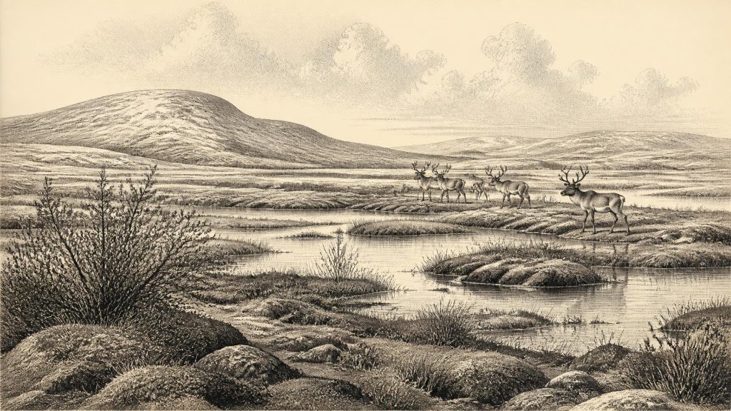
The Derryvree material provides direct evidence for plants and conditions, not a picturesque certainty about every part of Ireland. Its pollen was poorly preserved, but plant macrofossils, moss remains and insects strengthen the environmental picture. The recorded flora included cold-tolerant herbs, grasses and sedges, with remains associated with damp ground, shallow freshwater and mossy margins. Bogbean and water-milfoil point to water or wet ground; dwarf willow, mountain avens and lesser clubmoss belong within a cold-climate assemblage. Taken together, these traces support an open, largely treeless, periglacial landscape with pools, saturated edges, exposed ground and short growing seasons.
“Tundra” is useful shorthand, but it should not be mistaken for an exact modern analogue or a uniform national landscape. Derryvree was one basin in south Fermanagh, not a complete map of the island. Its fossil plants show that even in a severe climate there were productive wet patches where aquatic vegetation, mosses and sedges could grow during the warmer part of the year. Seasonal freezing and thawing probably disturbed soils and altered drainage. The evidence supports harsh winters and sparse dry-land vegetation; it does not support claims for woodland, cultivated fields or a settled farming population.
The two tills enclosing the freshwater bed tell an equally important story of change. The lower till records an earlier glacial episode; the organic silts and sands record a period when the locality supported open water and vegetation; the upper till shows that ice subsequently crossed or overwhelmed the site. The present drumlin is therefore an archive of advance, respite and renewed glaciation. Much of the surface familiar in modern Ireland was still being reshaped by ice, meltwater, frost and sediment movement rather than by the slower processes of soils, woodland and agriculture that transformed the island later.
Ice Was Building, Not Yet at Its Fullest Extent
This date belongs to Marine Isotope Stage 3, before the fullest expansion of the last British–Irish Ice Sheet. Modern reconstructions indicate sustained ice-sheet growth from about 31,000 to 26,000 years ago, followed by a maximum volume around 23,000 years ago. Offshore evidence shows that ice streams later reached far across the Atlantic and Celtic Sea shelves. Those broad reconstructions explain why Derryvree’s inter-till deposit is so significant: it records an ice-free freshwater episode in a landscape approaching a much more extensive glacial phase.
That does not entitle us to say that all of Ireland was simultaneously ice-free in 30,211 BCE. Ice margins were dynamic, regional and difficult to date with annual precision. Upland and coastal sectors could have differed sharply from lowland Fermanagh, while marine ice, valley ice, periglacial ground and vegetated wetlands existed in changing combinations. Nor can a modern coastline be projected backwards without qualification. Globally lower sea levels altered the surrounding shelves, but the routes available to animals or people depended on changing ice, sea level, rivers, terrain and weather. The archaeological evidence does not demonstrate a particular land bridge, crossing route or migration at this date.
Castlepook and the Human Question
County Cork supplies the most provocative, but also the most limited, evidence relevant to Ireland’s earliest possible people. Castlepook Cave near Doneraile, historically called Mammoth Cave, produced a remarkable collection of Pleistocene animal bones during excavations in the early twentieth century. Reassessment of a reindeer femur identified a deep linear mark interpreted by zooarchaeologist Ruth Carden as a cut made by a sharp stone tool while fresh bone was being processed. County Cork heritage material has assigned the specimen broadly to about 31,000 BCE. If the mark is correctly identified and broadly contemporary with the animal’s death, it may indicate that people handled a reindeer in Ireland during this general period.
The conclusion must remain cautious. A radiocarbon result dates the death of an animal, not automatically the instant at which a surface mark was made. Castlepook’s old collections derive from a cave used and disturbed by carnivores, water movement, sedimentary processes and antiquarian excavation. The cave contains remains accumulated over long periods, not a sealed snapshot of one hunting expedition. No securely associated hearth, stone-tool assemblage, dwelling floor, burial, human bone, occupation surface or artwork of comparable age has been published from the site. The femur is therefore a potentially transformative clue to fleeting human activity, not proof of a permanent settlement or continuous population.
Its importance lies partly in how much it challenges older assumptions. For many years, substantial Irish evidence for people began only with post-glacial hunter-gatherers of the Mesolithic, thousands of years later. The Castlepook bone raises the possibility that Upper Palaeolithic visitors reached Ireland far earlier, perhaps during a favourable interval in the changing Ice Age landscape. Yet it cannot identify their language, ancestry, numbers, sex, kinship, technology beyond the possible use of a sharp stone edge, or relationship to later Irish populations. Those questions remain open because the evidence required to answer them has not been found.
Animals, Resources and Limits
Castlepook does demonstrate that Ireland formed part of a wider Pleistocene animal world. Its faunal archive includes reindeer, woolly mammoth, giant deer, brown bear, wolf, Arctic fox, spotted hyaena, mountain hare and lemmings, though not all species need have lived there at the same time. Carnivores could have dragged carcass parts into the cave, and dates from individual bones show that assemblages may combine material separated by many millennia. The secure interpretation is not that these animals formed one simultaneous “menagerie”, but that cold-stage habitats in and around Ireland were capable of supporting a varied fauna over the wider period.
If people did visit, reindeer would have offered meat, marrow, hide, sinew, antler and bone. That is an inference from the animal and from hunter-gatherer practice elsewhere, not a demonstrated Irish economy. There is no evidence at this date for exchange networks, boats, storage facilities, livestock, crops, mining, metalworking or trade. Nor is there evidence for political communities, leaders, warfare, diplomacy, law, formal religion, monuments, art or teaching institutions. The absence of evidence cannot prove that every social practice was absent, but it does require historians to resist filling an Irish Ice Age landscape with institutions known only from far later prehistory.
History Written in Sediment
The most meaningful development around 30,211 BCE was environmental rather than political: Ireland stood within a cold, unstable phase in which wetlands could briefly flourish between glacial advances, while animal populations moved through changing habitats. Derryvree’s freshwater silts preserve an actual local ecosystem, and Castlepook’s bones preserve direct testimony to Ice Age fauna. The possible reindeer cut mark adds a tantalising human dimension, but remains a proposition to be tested through renewed excavation, rigorous dating and microscopic study.
For this remote period, responsible Irish history is a history of evidence and its limits. Sediment can show that a wetland existed; plant remains can indicate open cold-climate vegetation; animal bones can establish the presence of particular species; a modified bone may suggest human action. None can yield a named person or an exact year. The numbered date is best used as a signpost into a long, calibrated time range: an Ireland of frost-affected ground, shallow waters, scattered tundra plants, roaming animals and an unresolved question about the island’s first visitors.
Primary Sources
- Middle Midlandian Freshwater Series at Derryvree, Maguiresbridge, County Fermanagh, Northern Ireland
- Middle Midlandian Freshwater Series at Derryvree, Maguiresbridge, County Fermanagh, Northern Ireland
- Palaeoecology
- Figure 6.—The Subdivision of the Quaternary Period in Ireland
- Trimlines, Blockfields and the Vertical Extent of the Last Ice Sheet in Southern Ireland
- The Last Irish Ice Sheet: Extent and Chronology
- Growth and Retreat of the Last British–Irish Ice Sheet, 31,000 to 15,000 Years Ago: the BRITICE-CHRONO Reconstruction
- Maximum Extent and Dynamic Behaviour of the Last British–Irish Ice Sheet West of Ireland
- Advance and Retreat of the Marine-Terminating Irish Sea Ice Stream into the Celtic Sea During the Last Glacial: Timing and Maximum Extent
- Radiocarbon Constraints on the Age of the Maximum Advance of the British–Irish Ice Sheet in the Celtic Sea
- The Deglaciation of the Western Sector of the Irish Ice Sheet from the Inner Continental Shelf to its Terrestrial Margin
- Stratigraphic and Palaeo-Geomorphological Evidence for the Glacial-Deglacial History of the Last British-Irish Ice Sheet in the North-Western Irish Sea
- The Timing and Magnitude of the British–Irish Ice Sheet Between Marine Isotope Stages 5d and 2
- Deglaciation Chronology of the Donegal Ice Centre, North-West Ireland
- The Irish Quaternary Fauna Project
- The Exploration of Castlepook Cave, Co. Cork. With 3 Plates.
- Heritage Artefacts of County Cork
- New Insights on the Fauna of Ireland's Younger Dryas and Early Holocene from Alice & Gwendoline Cave
- The Mesolithic in Ireland: When Was It?
- Irish Association for Quaternary Studies Guide 13
- Pleistocene Glaciations in Ireland
- The IntCal20 Northern Hemisphere Radiocarbon Age Calibration Curve (0–55 cal kBP)





