Derryvree’s Water-Milfoil30996 BCE
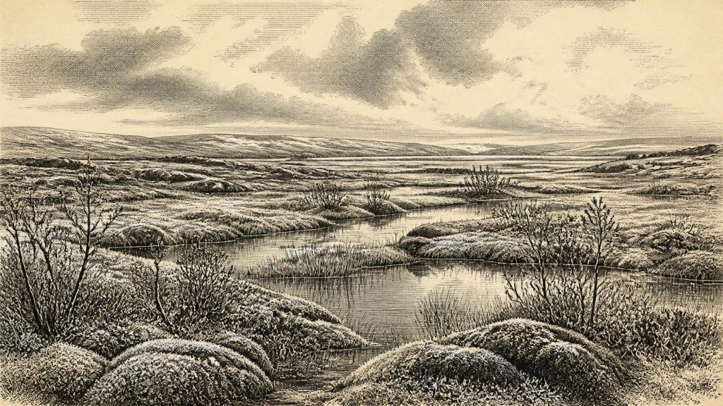
About 30,996 BCE, Ireland’s evidence is environmental rather than historical. At Derryvree, County Fermanagh, freshwater silts and organic deposits between glacial tills record a cold, ice-free interval during Marine Isotope Stage 3. Water-milfoil, sedges, mosses, bogbean and dwarf shrubs indicate treeless, muskeg-like tundra wetland shaped by short summers and freezing conditions. Elsewhere, southern cave deposits show intermittent presence of mammoth, reindeer, giant deer and predators. A possibly cut-marked reindeer bone suggests, but cannot prove, human visitation. No secure settlement evidence exists. Changing ice, sea levels and geography governed habitats, preserving only fragmentary traces of Late Pleistocene Ireland at this date.
Dateline
The modern label 30,996 BCE cannot identify a particular Irish event, season or generation. Nobody in Ireland kept a calendar at this depth of time, and neither archaeological nor environmental dating can responsibly resolve a single year so far back. In calendar terms this point falls roughly 32,900–33,000 years before AD 1950, within the Late Pleistocene and broadly Marine Isotope Stage 3. The appropriate evidence is therefore regional and range-based: deposits, fossils and radiocarbon determinations with substantial uncertainties, rather than a narrative of named people or dated events.
The closest Irish environmental archive is at Derryvree near Maguiresbridge, County Fermanagh. There, a road cutting in 1969 exposed freshwater silts, fine sands and organic material sealed between two layers of glacial till within a drumlin. A radiocarbon measurement from the deposit, 30,500 ± c.1,100 radiocarbon years BP, has been calibrated in later discussion to a broad calendar range that overlaps the notional date considered here. It records an interval when this part of Fermanagh was not beneath glacier ice, before a subsequent ice advance covered and preserved the wetland sediments. It does not record the whole island at one instant, but it gives an unusually vivid local view of Ireland during a severe phase of the last Ice Age.
A Wetland Between Glaciers
Derryvree overturns the easy image of an Ireland continuously smothered beneath unbroken ice. The lower till proves an earlier glacier had crossed the area. Above it, freshwater deposits accumulated in a hollow or shallow basin. The upper till demonstrates that ice later returned. Between those episodes lay a cold but living landscape: water, sediment, plants, insects and mosses survived long enough to leave an archive. This sequence is often assigned to the Derryvree Cold Phase, part of the regional Midlandian glacial succession.
The plant evidence indicates open, treeless tundra or tundra-like wetland, not the wooded island familiar from later prehistory. Herb pollen is plentiful, although often poorly preserved. Macrofossils and moss remains provide more specific testimony. Sedges and grasses grew around wet ground; water-milfoil indicates shallow freshwater; bogbean, mountain-avens, dwarf willow and clubmoss point towards cold, exposed conditions. The combined evidence has been described as muskeg-like: waterlogged, uneven ground with pools, saturated vegetation and low growth rather than a modern blanket bog. Seasonal freezing, short summers and strong winds would have shaped the terrain.
This was not a landscape without productivity. During the brief growing season, wet hollows could support aquatic plants, mosses and sedges, while drier patches carried sparse herbs and dwarf shrubs. Yet the scale of that productivity should not be romanticised. There is no indication of forest, arable ground, livestock or permanent village life. The plants reveal an ecosystem adapted to cold and disturbance, not a comfortable refuge. Their survival also shows why a local site matters: even in a glacial climate, a basin with fresh water could sustain a distinctive community of organisms.
Climate, Ice and Changing Geography
The date belongs to a climatically unstable interval before the Last Glacial Maximum, when the British–Irish Ice Sheet reached its greatest known extent around 25,000–23,000 years ago. Around 33,000 calendar years BP, ice was expanding and shifting across the wider region, but its limits were neither static nor uniform. Derryvree itself preserves an ice-free interval; it cannot be used to claim that all of Ireland was open country at precisely the same time. Conversely, later evidence for extensive ice does not mean that every Irish valley was permanently frozen at this earlier point.
Sea level was lower than today because enormous quantities of water were held in continental ice sheets. Ireland was consequently part of a broader north-west European geographical system with altered coastlines and exposed shelf landscapes. Precisely where dry land, tidal channels and water barriers lay changed through time, and researchers continue to refine those reconstructions. It is reasonable to infer that animals could reach Ireland during suitable phases, because the fossil record shows repeated colonisation. It is not responsible, however, to draw a simple, permanent ‘land bridge’ on a map or to assume that people and animals crossed the same route at the same date.
Regional change was thus the major historical force. Glacier growth could erase soils, reroute drainage and compress habitable terrain into local ice-free zones. Frost shattered exposed rock and repeatedly disturbed surface deposits. Later ice and meltwater removed much evidence that might once have existed. The scarcity of sites from this period is therefore not proof of an empty island; neither is it proof of a sizeable human population. It is a condition of the surviving record.
Animals in an Open Country
Southern Irish caves, especially Castlepook Cave or Mammoth Cave near Doneraile in north County Cork, supply a complementary faunal record. Their deposits have produced bones of woolly mammoth, reindeer, giant deer, brown bear, wolf, fox, mountain hare, lemmings and spotted hyaena. These are not a single herd or a single moment preserved together. Cave deposits accumulated across long periods, were affected by carnivores, water movement, excavation history and later reassessment. Improved radiocarbon pretreatment has shown that several older determinations from Castlepook need caution and that parts of the fauna are older than formerly supposed.
Nevertheless, the assemblage establishes an important point: Ireland intermittently supported large herbivores and their predators during Marine Isotope Stage 3. Reindeer and mammoth evoke open feeding grounds; hyaenas, wolves and bears show that carcasses and caves were part of a wider predator–scavenger landscape. A cave is not a neutral census of all animals nearby. Hyaenas may have dragged bones in, animals may have died naturally, and deposits may mix material from separate episodes. The evidence supports a changing cold-country fauna, not a precise reconstruction of what stood beside the Derryvree pool in 30,996 BCE.
For people, the most intriguing but least settled evidence is a reindeer femur from Castlepook reported to have a deep mark consistent with cutting by a stone tool. It has been publicly associated with an age of about 33,000 radiocarbon years BP; that is a radiocarbon age, not the same as 33,000 calibrated calendar years BP, and it may pre-date the Derryvree interval by several millennia. The bone raises the possibility that a human visitor butchered a reindeer in Ice Age Ireland. It does not demonstrate a settlement, a hunting camp, a family group or continuous occupation.
The Limits of Human History
No securely associated hearth, stone-tool assemblage, house floor, human burial, food store or occupation surface of this age has been excavated in Ireland. Accordingly, there is no evidence for political authority, diplomacy, organised warfare, territorial boundaries or named communities. There is equally no basis for describing a local religion, language, artistic tradition or system of learning. Such absences are historically meaningful: the sources available are geological and palaeontological, not documentary or social.
If the marked Castlepook bone ultimately proves human modification, it would be evidence for a brief act of carcass processing, perhaps by highly mobile Upper Palaeolithic hunter-gatherers familiar with the wider European world. A cut mark could imply the recovery of meat, marrow, hide or sinew; it cannot reveal who performed the act, whether they travelled alone or in a group, or whether they returned. The careful interpretation is therefore one of possible contact rather than colonisation. Ireland’s first firmly evidenced human presence remains much later, after the last major glaciation.
There can be no demonstrated economy or trade network for Ireland at this date. The closest defensible economic picture is ecological: wild animals moved through environments whose usable resources changed with weather, ice and season. If people reached the island, their subsistence would have depended on mobility and knowledge of animals, freshwater and sheltered ground. But that is an inference from comparable Upper Palaeolithic lifeways elsewhere, not direct Irish proof. It must remain clearly separate from the Derryvree fossils and Castlepook bones themselves.
What This Date Can Mean
For Ireland around this notional year, the central development was neither a battle nor a dynasty but an unstable environmental interval. At Derryvree, cold freshwater wetland formed between glacial advances. Mosses, sedges, bogbean and water-milfoil documented a living Arctic-alpine landscape in what is now County Fermanagh. Elsewhere, cave remains attest that large mammals and predators entered an Irish landscape connected ecologically, if not always physically, to north-western Europe. The possible reindeer cut mark offers an arresting human question, but not a settled answer.
That restraint is not a failure of history. It is the proper achievement of Ice Age research: to distinguish a dated deposit from a calendar year, an animal bone from a community, and a suggestive mark from proof of settlement. Around 30,996 BCE, Ireland can be seen only in fragments. Yet those fragments preserve a remarkable country of frost-affected ground, shallow pools, low vegetation, roaming fauna and approaching ice—an Ireland whose deep past is written not in chronicles, but in silt between tills.
Primary Sources
- A Middle Midlandian Freshwater Series at Derryvree, Maguiresbridge, County Fermanagh, Northern Ireland
- The Irish Quaternary Fauna Project
- A Reconsideration of the Radiocarbon Dating of the Marine Isotope Stage 3 Fauna from Southern Ireland
- The IntCal20 Northern Hemisphere Radiocarbon Age Calibration Curve (0–55 cal kBP)
- Palaeoecology
- The Subdivision of the Quaternary Period in Ireland
- Early Midlandian–Middle Midlandian, Pleistocene, Northern Ireland
- Menyanthes trifoliata
- Spotted Hyena Skull
- Heritage Artefacts of County Cork
- Ireland's Palaeolithic Archaeology – Fleeting Footprints in a Frozen Land
- Middle Midlandian Interstadial Deposits at Greenagho, Near Belcoo, County Fermanagh, Northern Ireland
- Trimlines, Blockfields and the Vertical Extent of the Last Ice Sheet in Southern Ireland
- Growth and Retreat of the Last British–Irish Ice Sheet, 31,000 to 15,000 Years Ago: the BRITICE-CHRONO Reconstruction
- BRITICE-CHRONO Maps and GIS Data of the Last British-Irish Ice Sheet 31 to 15 ka
- New Data for the Last Glacial Maximum in Great Britain and Ireland
- Dimensions and Chronology of the Last Ice Sheet in Western Ireland
- Last Glacial Maximum Cirque Glaciation in Ireland and Implications for Reconstructions of the Irish Ice Sheet
- Oscillating Retreat of the Last British-Irish Ice Sheet on the Continental Shelf Offshore Galway Bay, Western Ireland
- Stratigraphic and Palaeo-Geomorphological Evidence for the Glacial-Deglacial History of the Last British-Irish Ice Sheet in the North-Western Irish Sea
- New Insights on the Fauna of Ireland’s Younger Dryas and Early Holocene from Alice & Gwendoline Cave
