

BIRM-166’s Bogbean Seed30965 BCE
30,965 BCE is a modern label within volatile MIS 3 phase, not a precisely observable Irish year. At Derryvree, County Fermanagh, BIRM-166 organic sediments between glacial tills, dated broadly 36,900–31,700 calibrated years BP, record an ice-free interval with tundra wetland, bogbean, mosses, insects, sedges and grasses. Greenagho provides comparable evidence. Castlepook Cave, County Cork, preserves mammals including mammoth, reindeer, giant deer, hyaena and Arctic fox, though its mixed deposits require caution. A marked reindeer bone may suggest intermittent human visits, but proves no settlement. Ireland lacked demonstrable polities, economy or culture, while approaching renewed glaciation before the Last Glacial Maximum.
Dateline
30,965 BCE is a modern chronological label, not a year that can be observed in the Irish archaeological record. There are no written sources, settlements, graves or artefact assemblages that can be assigned to that single year. In calendar terms it falls roughly 32,900 years before AD 1950, within the later part of Marine Isotope Stage 3 (MIS 3), a climatically volatile interval of the last Ice Age. The responsible approach is therefore to use broad calibrated ranges, not to invent an episode for an exact date. Ireland’s evidence consists chiefly of sediments sealed beneath later glacial deposits, cave faunas and changing ice-sheet landforms. Together they illuminate a severe, treeless and shifting environment, while leaving human presence at this time uncertain.
Dating a Calendarless Landscape
Radiocarbon years are not calendar years. A laboratory determination must be calibrated against changing atmospheric carbon levels, and results this old commonly produce wide ranges. The key Irish deposit is at Derryvree near Maguiresbridge, County Fermanagh, where roadworks in 1969 cut through a drumlin. Beneath its surface lay two separate sheets of glacial till, with freshwater silts, sands and organic layers caught between them. The organic deposit, known as BIRM-166, produced a conventional radiocarbon result of 30,500 years BP with a substantial uncertainty. Published calibration places the episode broadly around 36,900–31,700 calibrated years BP. The notional date of 30,965 BCE falls within that broad window; it does not identify the precise moment when a particular pond formed, a seed fell or an animal crossed the ground.
This is nevertheless unusually valuable evidence. The lower till shows that glacier ice had previously occupied the locality. The organic bed records an intervening period in which freshwater and vegetation existed there. The upper till shows that ice later returned or expanded across the area. Derryvree therefore disproves any simple picture of Ireland as continuously ice-covered throughout the whole last glacial cycle. It does not, however, supply a detailed island-wide map. A protected sediment lens under a Fermanagh drumlin preserves a local sequence; later glaciers removed or disturbed much else. At Greenagho near Belcoo, also in Fermanagh, organic material beneath till has been dated broadly to 37,200–35,700 calibrated years BP, reinforcing the conclusion that parts of north-central Ireland remained ice-free during earlier MIS 3 intervals.
Wet Ground Beneath a Drumlin
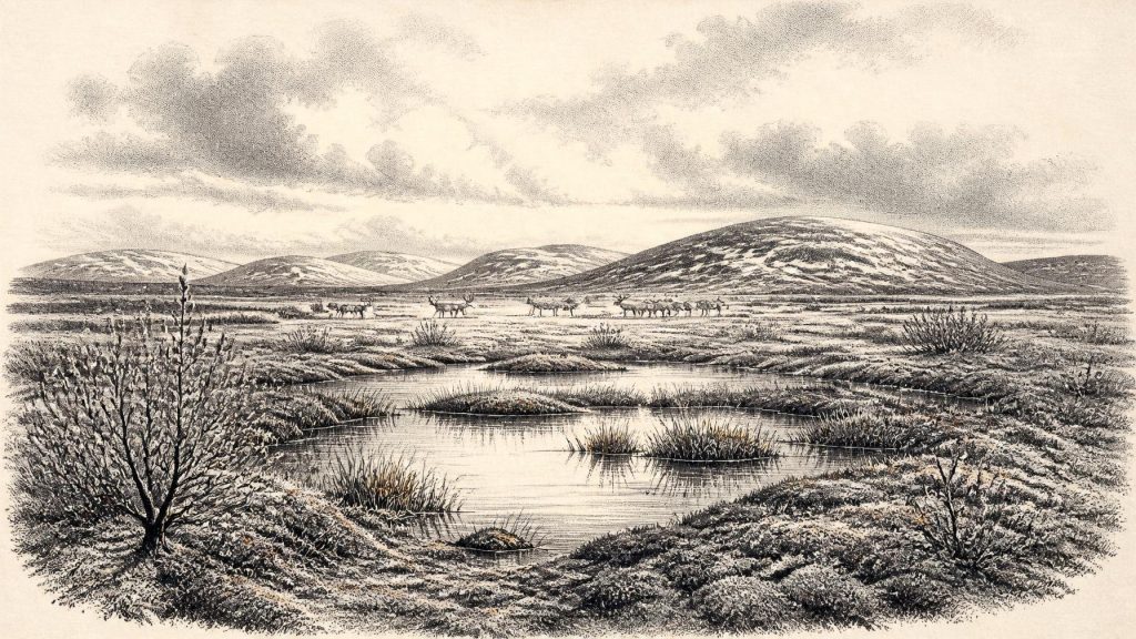
Derryvree’s fossils depict a tundra wetland rather than a forest or a familiar Irish bog. Pollen was poorly preserved, but plant macrofossils, mosses and insect remains point to open, cold country with pools and waterlogged ground. Sedges and grasses were important components, alongside small hardy plants adapted to short growing seasons. The recovery of bogbean, Menyanthes trifoliata, is especially striking: it is a plant of shallow freshwater margins and marshy pools, and its fossil seed gives the article its title. Mosses and aquatic plants indicate that this was not a lifeless frozen waste. Yet their presence should not be mistaken for a mild climate. The wider setting was periglacial: repeatedly affected by freezing and thawing, with long cold winters, sparse dry-ground cover and little or no tree growth.
The available evidence suggests a mosaic rather than uniform tundra. Low-lying hollows could hold water, organic matter and sheltered vegetation; exposed ground would have been colder, windier and more thinly covered. Summer thaw may have made soft ground around pools, while winter frost transformed the same landscape. Such conditions controlled where animals could graze, where predators could find prey and where any people might travel. They also left a record that is more ecological than scenic. We can responsibly identify freshwater plants, cold-adapted insects and glacial sediments. We cannot reconstruct a particular day’s weather, name a river crossing, or assume that every part of Ireland resembled Derryvree.
Cork’s Cave Fauna
County Cork provides the other major window onto Ireland’s MIS 3 world. Castlepook Cave, near Doneraile, yielded a remarkable collection during excavations led by Richard Ussher in the early twentieth century. The bone assemblage includes woolly mammoth, reindeer, giant deer, brown bear, wolf, Arctic fox, hare, lemmings and spotted hyaena. Re-dating has demonstrated that some older radiocarbon determinations from Irish caves needed revision, but Castlepook remains the principal evidence for a pre-Last Glacial Maximum mammal community in Ireland. It documents an open landscape capable of supporting large herbivores as well as formidable carnivores, not an island wholly locked beneath permanent ice.
The cave must be read carefully. A cave bone collection is not a census of every animal alive together at one moment, nor a straightforward picture of a hunting camp. Castlepook’s deposits accumulated through water movement, animal activity, excavation disturbance and long periods of use. Hyenas appear to have been important agents in the assemblage: their presence indicates that carcasses and bones could have been dragged, chewed and scattered by carnivores. Mammoth, reindeer and giant deer demonstrate the availability of large grazers and browsers across the wider region at some point in this cold phase. The absence of a species from a particular deposit cannot prove its absence from Ireland, particularly where fossil survival is patchy and later glaciation was destructive.
The Human Question
A reindeer femur from Castlepook has been publicised as bearing a deep mark consistent with stone-tool butchery and as potentially indicating human activity in Ireland about 33,000 years ago. It is an important claim, but it remains insufficient by itself to establish a settled population, a named culture or even a repeatedly occupied camp. The bone has no securely associated hearth, lithic assemblage, dwelling surface, human burial or concentration of butchered prey. Moreover, recent reassessment of Irish cave dates has shown why old collections and their chronologies require renewed testing. The strongest securely evidenced Palaeolithic human activity presently recognised in Ireland is much later, at Alice and Gwendoline Cave in County Clare during the terminal Pleistocene.
For 30,965 BCE, the prudent conclusion is that people may have reached Ireland intermittently, perhaps following mobile animal resources during favourable climatic intervals, but their presence is not established by a robust archaeological settlement record. Ireland was separated from Britain by sea, although lower sea levels altered coastlines and narrowed crossings. Neither a land bridge nor a route used by people can be asserted for this exact time from the surviving Irish evidence. If small parties did visit, they would have needed exceptional knowledge of weather, animals, fuel and shelter. That is a plausible inference from the environment, not evidence for a permanent community.
No Polities, No Proven Exchange
There is no basis for describing political affairs, diplomacy, warfare, leadership, territory or institutions in Ireland at this date. There are likewise no demonstrated farms, herds, fields, houses, trade networks, mines or craft workshops. Terms such as ‘economy’ can only be used in the most limited ecological sense: animal movements, usable freshwater, seasonal vegetation and access to sheltered ground set the material possibilities of life. The cave fauna suggests food webs centred on large mammals and their predators, while Derryvree records productive wetland niches on a much smaller scale. It does not show that humans controlled these resources.
Religion, art and learning are equally beyond recovery here. No Irish ritual site, figurative art, musical instrument, burial practice or symbolic object can be reliably assigned to around 30,965 BCE. It would be misleading to import the famous cave art, burials or tool traditions of continental Europe and treat them as Irish evidence. The people who made such works elsewhere demonstrate the cultural capacities of Upper Palaeolithic populations, but they do not prove comparable activity on this island. Ireland’s own archive is environmental first, archaeological only in the most tentative sense.
Approaching Greater Ice
The wider significance of this period lies in transition. Major growth of the British–Irish Ice Sheet followed during the succeeding millennia, while its fullest Last Glacial Maximum extent came later, broadly between about 27,000 and 21,000 years ago in many reconstructions. At 30,965 BCE, Ireland stood in neither a timeless frozen void nor a settled prehistoric homeland. It was a region of unstable cold climates, locally ice-free terrain, freshwater hollows and open animal country, increasingly vulnerable to renewed glaciation. BIRM-166’s bogbean seed, preserved beneath a later drumlin, captures that fragile interval: evidence of living water and tundra vegetation before the ice altered the landscape again.
Primary Sources
- A Middle Midlandian Freshwater Series at Derryvree, Maguiresbridge, County Fermanagh, Northern Ireland
- Middle Midlandian Interstadial Deposits at Greenagho, Near Belcoo, County Fermanagh, Northern Ireland
- Early Midlandian–Middle Midlandian, Pleistocene, Northern Ireland
- Palaeoecology
- Figure 6.— The Subdivision of the Quaternary Period in Ireland
- Irish Pleistocene Biostratigraphy
- A Reconsideration of the Radiocarbon Dating of the Marine Isotope Stage 3 Fauna from Southern Ireland
- The Irish Quaternary Fauna Project
- Occurrence of Mammalia Relicts at Site Castlepook Cave
- Heritage Artefacts of County Cork
- New Insights on the Fauna of Ireland's Younger Dryas and Early Holocene from Alice & Gwendoline Cave
- Castlepook Cave Excavation, Castlepook South, County Cork
- Episodic Speleothem Deposition Tracks the Terrestrial Impact of Millennial-Scale Last Glacial Climate Variability in SW Ireland
- Extent and Timing of the Last Glacial Maximum in Britain and Ireland: A Review
- Reconstructing the Last Irish Ice Sheet 2: A Geomorphologically-Driven Model of Ice Sheet Growth, Retreat and Dynamics
- Dimensions and Chronology of the Last Ice Sheet in Western Ireland
- Trimlines, Blockfields and the Vertical Extent of the Last Ice Sheet in Southern Ireland
- The Deglaciation of the Western Sector of the Irish Ice Sheet from the Inner Continental Shelf to its Terrestrial Margin
- The IntCal20 Northern Hemisphere Radiocarbon Age Calibration Curve (0–55 cal kBP)
- Pleistocene Vertebrates in the British Isles