

Maguirebridge’s Frost Garden30966 BCE
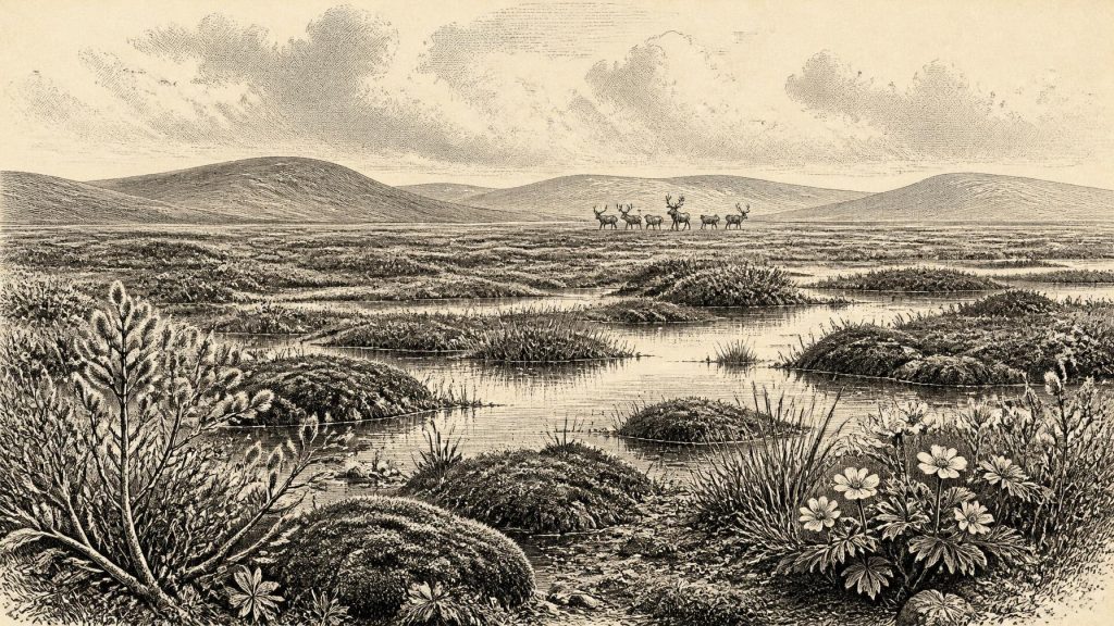
Around 30,966 BCE, Ireland lay within the climatically unstable Late Pleistocene MIS 3, not a dateable historical episode. Sediments at Derryvree, County Fermanagh, record a temporary ice-free freshwater environment between glacial advances, supporting tundra-like wetlands of sedges, mosses, bogbean, dwarf willow and other cold-adapted plants. Crag Cave indicates repeated milder and colder phases. Southern cave deposits show intermittent presence of mammoth, reindeer, giant deer, predators and scavengers, though chronology remains uncertain. No accepted evidence demonstrates human occupation. Expanding British-Irish ice repeatedly reshaped landscapes, while local refuges sustained vegetation and fauna. This was a dynamic, frost-bound environment, not documented human history.
Dateline
The label 30,966 BCE gives a useful point of reference, but it must not be mistaken for a date in the historical sense. No event, journey, ruler or settlement in Ireland can be assigned to this individual calendar year. This was deep within the Late Pleistocene, during Marine Isotope Stage 3 (MIS 3), a long and climatically volatile part of the last glacial cycle. In conventional archaeological terms, 30,966 BCE lies roughly 32,915 years before 1950, the reference year used for “BP” dates. Yet evidence from this age normally comes with uncertainties measured in centuries or millennia. The responsible task is therefore to describe the environmental horizon around the date, not to invent an Irish episode for it.
A Date Inside a Wider Interval
The strongest Irish evidence relevant to this horizon comes from Derryvree, near Maguiresbridge in County Fermanagh. In 1969 a road cutting exposed sediments inside a drumlin: glacial till below, freshwater silts and fine sands in the middle, and later till above. The sequence matters because it records an interval when this particular place was not buried beneath moving ice, before a subsequent ice advance sealed the deposits. Organic material from the freshwater bed produced the conventional radiocarbon determination BIRM-166, 30,500 radiocarbon years BP, with a substantial laboratory uncertainty. Published calibration places the deposit broadly within later MIS 3, rather than pinning it to a single calendar year.
That distinction is fundamental. A radiocarbon determination is not an anniversary. It dates carbon in sampled organic material, subject to measurement limits, sample history and later calibration against changing atmospheric radiocarbon. Nor does a deposit accumulate instantaneously. The Derryvree bed may represent years, generations or longer phases of sedimentation, while the fossil material within it need not all be exactly contemporary. Its calibrated range overlaps the general era represented by 30,966 BCE, but cannot demonstrate what happened in Ireland in that numbered year.
Even so, Derryvree is exceptionally revealing. It shows that, during part of this cold period, freshwater and wet ground existed in south Fermanagh between episodes of glaciation. Ireland was not simply an unchanging white blank on the edge of an ice sheet. It contained highly local environments shaped by water, frozen ground, wind, seasonal thaw and advancing or retreating ice. The island’s landscape was unstable in geological as well as climatic terms.
A Treeless Wetland Landscape
The fossil evidence from Derryvree points to open tundra or tundra-like vegetation in a periglacial climate. Plant pollen is poorly preserved, but the surviving record is dominated by herbs rather than woodland trees. Macrofossils, including mosses, sedges and aquatic or wetland plants, provide the more vivid evidence. Bogbean, mountain-avens, dwarf willow and other cold-adapted taxa indicate a mosaic of shallow water, marshy hollows, damp ground and sparsely vegetated mineral soils. Juniper may have occurred locally, but there is no sound basis for imagining forest.
This was a landscape of sharp constraints but not biological emptiness. In summer, melting snow and seasonal runoff could feed pools and sedge margins. Mosses and small flowering plants could exploit sheltered, waterlogged ground; insects occupied the same restricted habitats. Beyond the wet hollows, vegetation was probably patchy. Frost action disturbed soils, and prolonged winter cold curtailed growing seasons. The modern phrase “mammoth steppe” can be useful as a broad northern Eurasian comparison, but it should not conceal local variety. Derryvree records a particular freshwater setting in Fermanagh, not a complete map of every Irish region.
Crag Cave in County Kerry offers complementary, though different, evidence for climatic instability. Episodes of stalagmite growth there during MIS 3 required liquid water to percolate through the cave and are interpreted as phases when mean annual conditions rose above freezing. Their alternation with breaks in growth reflects abrupt millennial-scale swings between relatively milder and markedly colder conditions. At a horizon such as 30,966 BCE, Ireland’s climate should therefore be understood as fluctuating within a severe glacial world, not as a single uniform “Ice Age climate”.
Animals on a Changing Island
Cave deposits in southern Ireland demonstrate that a richer late-Pleistocene fauna entered Ireland at various times before the Last Glacial Maximum. Castlepook Cave, near Doneraile in north County Cork, has produced remains attributed to woolly mammoth, reindeer, giant deer, brown bear, wolf, Arctic fox, lemmings and spotted hyaena. The cave is an important archive because these animals reveal the kind of open, cold-country habitats that could exist in Ireland during MIS 3.
But a cave bone is not a census entry. Many Castlepook finds were excavated in the late nineteenth and early twentieth centuries, when recording methods were uneven. Cave floors can be disturbed by animals, water, collapse, earlier digging and redeposition; bones from different centuries or millennia can consequently lie close together. Modern redating has shown that several earlier determinations from Castlepook and neighbouring caves were too young, changing the chronology of the fauna substantially. The evidence supports intermittent animal presence in Ireland during MIS 3, but it cannot securely reconstruct a single herd, predator population or food web for 30,966 BCE.
Nevertheless, the ecological implications are important. Reindeer and lemmings are consistent with cold, open country; mammoth and giant deer imply enough forage and traversable terrain during favourable seasons; hyaenas, wolves and bears indicate that the island’s animal communities could include large carnivores and scavengers as well as herbivores. Such animals would have moved through a landscape broken by wet basins, uplands, river valleys and ice margins. Their presence also reminds us that Ireland’s later historic fauna is a poor guide to its Pleistocene past.
No Demonstrable Irish Society
There is no accepted evidence for a human community, camp, hearth, burial, tool-making site or political group in Ireland at this date. Consequently, there can be no responsible account of Irish government, diplomacy, warfare, religion, learning, trade or social hierarchy for 30,966 BCE. These categories belong to human societies; the evidence presently available for Ireland at this horizon is overwhelmingly environmental and faunal.
A reindeer bone from Castlepook has been discussed as potentially bearing a human-made cut mark and has encouraged renewed attention to the possibility of an earlier Upper Palaeolithic visit. It is an important question, not a licence to populate Ireland with hunters. A single contested or contextually insecure mark cannot prove sustained occupation, establish a route of arrival, or reveal a culture. The first firmly dated evidence of human activity currently accepted for Ireland is much later: cut marks on a brown-bear bone from Alice and Gwendoline Cave in County Clare, dated to about 12,800–12,600 calibrated BP. Permanent or repeated settlement is later again, in the Early Mesolithic.
That silence is historically meaningful. Around 30,966 BCE, groups of Homo sapiens certainly occupied parts of Europe and Britain was connected to wider continental landscapes during periods of lower sea level. Yet proximity is not evidence of arrival. Whether any people reached Ireland during a particular MIS 3 interval remains unresolved, and the sea, exposed shelves, glaciers and shifting coastlines would all have affected possible routes. Ireland’s archaeological record is also incomplete: acidic soils preserve little bone, later ice has removed or buried landscapes, and caves have been investigated unevenly. Absence of evidence is not proof that no person ever entered the island, but it does prevent claims of occupation.
Ice, Water and Regional Difference
The numbered year also falls near a crucial transition in the wider British–Irish Ice Sheet story. Recent reconstructions indicate that major ice-sheet growth accelerated around 32,000–30,000 years ago in parts of Britain and Ireland’s northern approaches, before the Last Glacial Maximum later brought far more extensive ice across Ireland. The timing, direction and extent of individual advances remain matters of active research. Derryvree’s position between two tills demonstrates glacial change at one Fermanagh locality; it does not prove that all of Ireland was ice-free simultaneously.
Regional differences were therefore decisive. A freshwater basin in south Fermanagh, a limestone cave in Cork, and a karst system in Kerry each preserve different fragments of the past. Their value lies precisely in their incompleteness: together they show that Ireland contained refuges of water, vegetation and animal life during phases of the last glacial cycle, while ice repeatedly altered the terrain and erased evidence elsewhere. There were no recognisable provinces, peoples or borders. The most consequential “politics” of the time were the movements of ice and the opening or closing of habitable ground.
What This Year Can Mean
For Ireland, 30,966 BCE is best treated as a window onto a cold, dynamic and largely humanly undocumented world. In and around the relevant date range, open vegetation and wetland communities existed at Derryvree; large mammals and carnivores occurred in Ireland during the broader MIS 3 interval; and the British–Irish Ice Sheet was entering a period of expansion and reorganisation. These are observations supported by sediments, plant remains, cave fauna, radiocarbon measurements and cave mineral deposits. Any fuller picture—how animals migrated, whether people briefly visited, or precisely how far ice lay from a given valley—is interpretation, necessarily provisional.
The enduring image should therefore be neither an empty frozen wasteland nor an invented Palaeolithic Ireland of camps and clans. It is a frost-bound but living landscape: sedges and mosses around shallow Fermanagh water, sparse plants gripping disturbed ground, animals moving when habitat permitted, and glaciers capable of returning to cover and preserve the evidence. That is the scale on which Irish history can responsibly be written for this remote point in time.
Primary Sources
- Palaeoecology: Middle Midlandian Palaeoenvironment of South Fermanagh
- A Reconsideration of the Radiocarbon Dating of the Marine Isotope Stage 3 Fauna from Southern Ireland
- The Irish Quaternary Fauna Project
- Episodic Speleothem Deposition Tracks the Terrestrial Impact of Millennial-Scale Last Glacial Climate Variability in SW Ireland
- Growth and Retreat of the Last British–Irish Ice Sheet, 31,000 to 15,000 Years Ago: the BRITICE-CHRONO Reconstruction
- The Last Eurasian Ice Sheets – a Chronological Database and Time-Slice Reconstruction, DATED-1
- Maximum Extent and Dynamic Behaviour of the Last British–Irish Ice Sheet West of Ireland
- Trimlines, Blockfields and the Vertical Extent of the Last Ice Sheet in Southern Ireland
- Character of Advance and Retreat of the Southwest Sector of the British-Irish Ice Sheet During the Last Glaciation
- First Evidence of a Late Upper Palaeolithic Human Presence in Ireland
- New Insights on the Fauna of Ireland’s Younger Dryas and Early Holocene from Alice & Gwendoline Cave
- The Colonization of Ireland: A Human Ecology Perspective
- The Mesolithic in Ireland: When Was It?
- Heritage Artefacts of County Cork 2021
- Castlepook Caves
- Archaeological Excavation at Castlepook Cave, Co. Cork, 2022
- Menyanthes trifoliata L.
- Dryas octopetala L.
- The IntCal20 Northern Hemisphere Radiocarbon Age Calibration Curve (0–55 cal kBP)
- Occurrence of Mammalia Relicts at Site Castlepook Cave
- Mammoth Cave, County Cork
- Dansgaard–Oeschger Events in Climate Models: Review and Baseline Marine Isotope Stage 3 Protocol