Derryvree’s Mossbound Waters30884 BCE
About 30,884 BCE, Ireland’s history can only be reconstructed from environmental evidence, not annual events or communities. At Derryvree, County Fermanagh, organic freshwater silts between glacial tills record an ice-free wetland phase, with mosses, sedges, aquatic plants, insects and treeless cold-adapted vegetation. Ireland’s climate during Marine Isotope Stage 3 changed sharply between cold episodes, milder intervals and advancing ice. Castlepook Cave preserves remains of mammoth, reindeer, giant deer, lemmings, foxes, wolves and hyenas, indicating open cold-country ecosystems. Human settlement is unproven; a possibly cut-marked reindeer bone suggests only a tentative early visit. Later ice expansion buried or destroyed much evidence.
Dateline
Modern calendar-year precision is not available for Ireland in 30,884 BCE. No Irish community then used a calendar, left writing, or produced a dated event that can be attached to that numbered year. The label is nevertheless useful as a point within the Late Pleistocene: roughly 32,833 calibrated years before present, using 1950 as the conventional ‘present’ in archaeological dating. It falls in Marine Isotope Stage 3 (MIS 3), a long, unstable part of the last Ice Age. The responsible history of this moment is therefore not an annal of rulers or battles, but a reconstruction from glacial sediments, fossil plants, animal bones, cave deposits and radiocarbon ranges.
A Date Within Broad Ranges
Radiocarbon years are not calendar years. The principal environmental deposit relevant to this article, at Derryvree near Maguiresbridge in County Fermanagh, produced a conventional radiocarbon result of about 30,500 ± 1,100 radiocarbon years BP. Calibration places that evidence broadly between about 36,900 and 31,700 calibrated years BP. Thus 30,884 BCE lies within the wider calibrated span associated with the deposit, but it cannot identify a particular season, pool, plant or animal living there in that precise modern year. IntCal20, the current Northern Hemisphere calibration framework, allows such old measurements to be translated into probability ranges; it does not convert them into annual historical dates.
This distinction matters because Ireland’s evidence is sparse, local and often disturbed by subsequent ice, water and early excavation. A sediment bed can demonstrate that freshwater conditions existed before a later ice advance. It cannot establish the political boundaries, languages, names, beliefs or daily itinerary of people. Likewise, a dated animal bone establishes that an animal died within a broad range, not that its species occupied all parts of Ireland simultaneously. The evidence is substantial enough to describe a severe but living landscape; it is insufficient for a conventional year-by-year narrative.
Freshwater Between Two Ice Sheets
Derryvree is the clearest Irish window onto this interval. Roadworks in 1969 cut through a drumlin north-east of Maguiresbridge and exposed organic silts and fine sands sealed between two thick till sheets. Till is debris laid down by moving glacier ice. The sequence therefore records three large environmental changes: ice first occupied the locality and left the lower till; an ice-free freshwater environment then developed; finally, a later advance buried it beneath a new till. The upper burial helped preserve material which would otherwise have been eroded or dispersed.
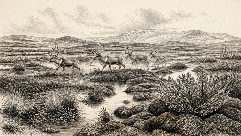
The organic beds contained plant and insect evidence characteristic of open, cold ground rather than woodland. Mosses, sedges and aquatic plants, including bogbean (Menyanthes trifoliata), point to wet, shallow water and waterlogged margins. Dwarf willow, mountain-avens, lesser clubmoss and other cold-adapted taxa belong to a low, treeless vegetation mosaic. Insects add an important ecological check: rather than merely indicating cold, they suggest a muskeg-like landscape of peaty wet ground, pools, emergent vegetation and abundant plant matter. “Muskeg” should not be imagined as a modern bog transferred unchanged into the past, but as a useful description of saturated, mossy, sediment-rich wetland conditions.
This was not a uniformly frozen desert. Even in a harsh climate, meltwater, springs and shallow basins could support freshwater plants and insects during suitable seasons. Nor does Derryvree prove that the entire island looked identical. It is a local archive in Fermanagh. Still, together with other Irish deposits and cave records, it shows that parts of Ireland could be ice-free, ecologically productive and exposed to marked climatic shifts before the fullest development of the last British-Irish Ice Sheet.
An Open, Changeable Country
At this time, Ireland stood near the Atlantic edge of a northern European climatic system prone to abrupt warming and cooling on millennial scales. Speleothem evidence from Crag Cave in County Kerry records episodes when liquid water could percolate through caves during the last glacial period, broadly corresponding to Greenland interstadials. Such records reinforce the central lesson of Derryvree: Ice Age Ireland was not environmentally static. Cold phases, short-lived ameliorations, permafrost conditions and renewed glacier growth formed a changing sequence rather than a single unbroken freeze.
For the date represented here, an open tundra or tundra-steppe landscape is a more defensible image than forest. Grasses, sedges, herbs, mosses and scattered low shrubs would have offered seasonal forage, while exposed ground and waterlogged hollows created sharply contrasting microhabitats. Winters were severe and long; summer growth was limited but important. The later ice sheet would reshape much of the terrain and destroy many potential archaeological deposits, helping to explain why the Irish record is so fragmentary.
Reindeer, Hyenas and Cave Archives
The principal faunal counterpart to Derryvree lies far to the south at Castlepook Cave, also called Mammoth Cave, near Doneraile in County Cork. Excavations there recovered more than 2,000 bones from complex cave deposits. The assemblage includes woolly mammoth, giant deer, reindeer, brown bear, wolf, Arctic fox, mountain hare, Norwegian lemming, collared lemming and spotted hyena. It is the richest known Irish vertebrate archive for the period before the Last Glacial Maximum.
These animals do not prove that every species stood together outside Castlepook in 30,884 BCE. The cave accumulated bones over a long interval, water disturbed parts of the deposits, and hyenas themselves may have carried carcass parts into their den. Some older identifications and radiocarbon determinations have also needed reassessment as methods improved. Yet the assemblage securely demonstrates that Ireland was at times occupied by a much broader cold-climate mammal community than the island supported in later millennia. Reindeer and mammoth imply extensive feeding grounds; lemmings and Arctic fox support the picture of open, cold habitats; hyenas and wolves show that large predators moved through the same wider ecosystem.
There is no basis for describing this as an Irish ‘economy’ in the later human sense. The animal community had food webs, not markets. Mammoth, reindeer and giant deer converted seasonal plant growth into large quantities of meat and other biomass; carnivores and scavengers exploited carcasses; caves could become dens, traps, shelters or repositories. Animal movement, fresh water and sheltered limestone ground were the relevant routes and resources. Evidence for organised trade, seafaring exchange or managed herds does not exist for Ireland at this date.
Ice Building Towards Its Maximum
Thirty thousand years ago, the British-Irish Ice Sheet was growing, though its maximum extent belonged to the later interval around 26,000–23,000 years ago. Modern reconstructions beginning at 31,000 years ago show expanding ice across Ireland, Britain and their surrounding shelves, but local evidence also preserves pre-maximum ice-free episodes. Derryvree’s freshwater silts are especially valuable because they make that point tangible: a wetland existed between glacier advances. By the Last Glacial Maximum, much of the earlier surface record would be buried, reworked or removed.
Regional change, therefore, was dominated not by states or diplomacy but by ice dynamics. Advancing ice altered drainage, stripped soils, dammed or redirected water, and narrowed habitable ground. Retreat or stagnation created temporary opportunities for vegetation and animals. At the scale of a human lifetime, if people were present, these shifts would have governed movement and survival more decisively than any recoverable social institution.
The Human Question
No securely excavated settlement, hearth, stone-tool assemblage, burial or dwelling demonstrates a resident human population in Ireland around 30,884 BCE. It would be wrong to invent hunter camps, kin groups, political leadership, religious rites, art or learning for this date. The secure evidence for human activity in Ireland is much later: a cut-marked brown-bear patella from Alice and Gwendoline Cave in County Clare dates to the terminal Pleistocene, around 12,810–12,590 calibrated BP. More sustained settlement is associated with the Early Holocene Mesolithic.
Castlepook does pose an earlier possibility. A reindeer femur from the cave has been reported as bearing a deep mark made on fresh bone by a sharp stone tool, and has been presented as evidence for butchery about 33,000 years ago. If that interpretation is eventually confirmed, it would show an exceptionally early human visit or episode of carcass processing. It would still not demonstrate a permanent settlement, a named people, repeated occupation, or a society extending across Ireland. The bone derives from an old, complex cave collection rather than a modernly excavated camp floor, and no securely associated hearth or lithic assemblage has yet transformed the claim into a full settlement record.
The most careful conclusion is consequently twofold. Human presence in Ireland at this depth of time remains possible and archaeologically important, but unproven as a settled way of life. The natural record is stronger: cold wetlands flourished briefly between ice advances; open-country mammals reached the island; and the expanding ice sheet was moving Ireland towards a far more glaciated future.
What Cannot Be Recovered
Political affairs, conflict, diplomacy, formal religion, education and cultural institutions cannot responsibly be described for 30,884 BCE. Their absence from the evidence is not proof that no human thought or social relationship ever occurred; it is a limit of the surviving record. What archaeology can recover is more elemental but no less significant: water pooled among mosses and sedges in Fermanagh, cold-adapted plants occupied open ground, and a remarkable animal world ranged through Ireland before later ice transformed the landscape. Derryvree’s buried wetland is not a dated event. It is a fragile witness to the environmental conditions that made any life in Ice Age Ireland possible.
Primary Sources
- A Middle Midlandian Freshwater Series at Derryvree, Maguiresbridge, County Fermanagh, Northern Ireland
- The Subdivision of the Quaternary Period in Ireland
- Palaeoecology
- Soils of County Waterford
- Castlepook Cave, County Cork Geological Site Report
- Spotted Hyena Skull
- Archaeology Research Excavation Grant 2022: Castlepook Cave Final Report
- 2022:160 – Castlepook Cave, Cork
- New Insights on the Fauna of Ireland’s Younger Dryas from Alice and Gwendoline Cave, Co. Clare
- The Colonization of Ireland: A Human Ecology Perspective
- The IntCal20 Northern Hemisphere Radiocarbon Age Calibration Curve (0–55 cal kBP)
- IntCal History
- Dansgaard–Oeschger Events in Climate Models: Review and Baseline Marine Isotope Stage 3 Protocol
- A 1.5-Million-Year Record of Orbital and Millennial Climate Variability in the North Atlantic
- Episodic Speleothem Deposition Tracks the Terrestrial Impact of Millennial-Scale Last Glacial Climate Variability in SW Ireland
- Growth and Retreat of the Last British–Irish Ice Sheet, 31,000 to 15,000 Years Ago: the BRITICE-CHRONO Reconstruction
- Exploring Controls of the Early and Stepped Deglaciation on the Western Margin of the British-Irish Ice Sheet
- The Timing and Magnitude of the British–Irish Ice Sheet Between Marine Isotope Stages 5d and 2
- The Irish Quaternary Fauna Project
- Pleistocene Vertebrates in the British Isles
- 2019:148 – Alice and Gwendoline Cave, Clare
- The Archaeology of Caves in Ireland
