Derryvree’s Intertill Biota30883 BCE
The label 30,883 BCE is not recoverable as a precise Irish year, but broadly falls within a Late Pleistocene interval represented by Derryvree, County Fermanagh. There, freshwater organic sediments between glacial tills show locally ice-free, periglacial wetland conditions, with sedges, mosses, herbs, dwarf willow, juniper and aquatic plants. Castlepook Cave, County Cork, preserves diverse Ice Age fauna, including mammoth, reindeer, giant deer and hyaena, although its mixed deposits cannot define a single moment. A possibly cut-marked reindeer femur suggests early human butchery, but proves neither settlement nor continuous occupation. Ireland’s evidence documents unstable environments, not political, cultural or economic history.
Dateline
“30,883 BCE” is a modern chronological label, not a year that can be recovered from Irish evidence. No calendar, written record, named community or dated event survives from this depth of time. At most, the label corresponds approximately to 32,800 calendar years before AD 1950, within the Late Pleistocene and Marine Isotope Stage 3. Radiocarbon ages of this antiquity require calibration and normally yield wide probability ranges rather than a single calendar year. The responsible history of Ireland at this point is therefore one of deposits, fossils and changing environments—not of rulers, battles or annual happenings.
The closest Irish archive is the Derryvree freshwater sequence near Maguiresbridge, County Fermanagh. Its organic sediments returned a conventional radiocarbon determination of 30,500 +1,170/−1,030 radiocarbon years BP. Modern calibration and later syntheses place the deposit broadly in the mid-to-late thirty-thousand calibrated-years-BP range; published expressions include approximately 36,900–31,700 cal BP. That broad span encompasses the notional date considered here. It does not mean that a particular pool, plant, animal or person can be dated to 30,883 BCE itself. It does mean that Derryvree provides Ireland’s most relevant local window on this phase of the last Ice Age.
A Wetland Between Glacial Advances
Derryvree was exposed accidentally during road works in February and March 1969, when a cutting passed through a drumlin. Beneath the familiar streamlined hill lay a remarkable sequence: freshwater silts and fine sands, including organic mud, caught between two substantial layers of glacial till. The stratigraphy is the fundamental evidence. Ice had previously deposited the lower till; subsequently, at least this locality was free of glacier ice long enough for water, sediment, plants and small creatures to accumulate; later ice advanced again and sealed the deposit under a second till.
That sequence is more informative than any attempt to make a map for a single modern-style year. It demonstrates locally ice-free ground during part of the dated interval, while also recording that the landscape belonged to a region repeatedly affected by glaciation. Later ice did not merely cover the old wetland: it reshaped the terrain, building or modifying the drumlin landforms for which Fermanagh is now famous. Much evidence of earlier landscapes was eroded, moved or buried in the same process. Derryvree is precious partly because its delicate organic remains survived this destructive history between protective layers of sediment.
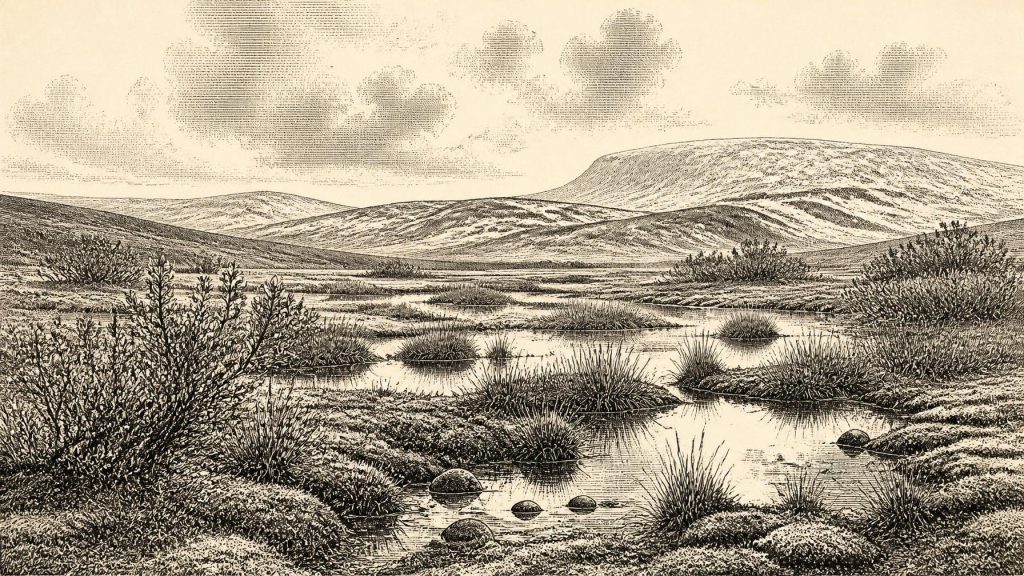
Its setting should not be imagined as modern bogland, nor as a featureless frozen desert. Fossil pollen was poorly preserved, but plant macrofossils, mosses and invertebrate evidence indicate a cold, open and frost-affected environment, often termed tundra or muskeg-like. Sedges, grasses and herbs occurred around shallow freshwater and wet ground. Mosses were notably diverse. Finds of mountain avens, dwarf willow, lesser clubmoss and bogbean are especially useful, while water-milfoil signals standing or slow-moving fresh water. Juniper was also present. Together, these remains support a mosaic of pools, marshy margins, low vegetation and sparsely covered mineral ground rather than continuous woodland.
Climate, Season and Landscape
The Derryvree evidence records a periglacial climate: harsh enough for intense seasonal freezing and thawing, but not necessarily one in which ice lay permanently over the site. Short growing seasons, strong winds, frost-disturbed soils and poor shelter would have limited vegetation. Yet summer growth around wet hollows could have been biologically productive. Aquatic plants and sedges, insects and low browse made particular patches more useful to animals than exposed slopes or gravelly surfaces. Ireland around this broad horizon was therefore neither simply “ice-covered” nor simply “temperate”: its habitats varied through time and from place to place.
This distinction matters because the island was moving towards the most extensive phase of the last British–Irish Ice Sheet. Research on the wider ice sheet places its major expansion after about 29,000 years ago, with maximum extent generally associated with roughly 25,000–23,000 years BP in the Irish Sea sector. The later maximum transformed Ireland’s coasts, drainage and soils on a vast scale. At 30,883 BCE, however, Derryvree indicates that a freshwater landscape could still persist in Fermanagh during a colder, unstable pre-maximum world. Its upper till supplies the reminder that this respite did not endure.
Conditions elsewhere cannot be read directly from one Fermanagh road cutting. Uplands, lowlands and coasts experienced different combinations of snow cover, ice proximity, drainage and exposure to Atlantic weather. Nor can a single radiocarbon result establish the precise margin of an ice sheet. The legitimate conclusion is narrower but important: some Irish ground was ice-free during the broad Derryvree interval, and supported cold-adapted wetland vegetation. That conclusion corrects the misleading picture of an island continuously blanketed by ice throughout the whole Late Pleistocene.
Castlepook’s Animal World
For large animals, the strongest complementary evidence comes from Castlepook Cave, near Doneraile in north County Cork, historically also called Mammoth Cave. Antiquarian excavations there, followed by modern study of museum collections and radiocarbon re-dating, have made it Ireland’s richest known archive of pre-Last Glacial Maximum vertebrate remains. Its assemblage includes woolly mammoth, reindeer, giant deer, brown bear, wolf, Arctic fox, hare, lemmings and spotted hyaena. These are not the animals of later wooded Ireland. They belong instead to a wider north-west European Ice Age fauna able, at different times, to reach and inhabit or visit the island.
Castlepook must nonetheless be handled with care. A cave is not a single moment sealed in time. Carnivores may drag in carcass parts; water, sediment movement, excavation methods and later disturbance can mix material from different episodes. Improved ultrafiltration dating has shown that some earlier determinations from Irish caves were too young, and that Castlepook’s pre-maximum fauna has a deeper and more complex chronology than once thought. The animal collection establishes that such species existed in Ireland across portions of Marine Isotope Stage 3. It cannot prove that every listed species shared one valley—or encountered one another—in 30,883 BCE.
Spotted hyaenas are particularly revealing. Their presence is consistent with open country capable of supporting substantial herbivores and with cave use by powerful scavengers and predators. Mammoth and giant deer likewise point to ecological connections beyond Ireland. But they are evidence for animal communities, not a licence to describe a local “mammoth steppe” in minute detail everywhere on the island. Fossil bones tell us where and when animals lived or were accumulated, not how an entire landscape looked on a particular day.
The Reindeer Femur Question
One Castlepook find makes this period archaeologically provocative: a reindeer femur that has been interpreted as bearing a cut mark made by a sharp stone edge while the bone was fresh. County Cork heritage material and researcher Ruth Carden have presented it as possible evidence that Upper Palaeolithic people processed a reindeer carcass in Ireland about 33,000 years ago. If that interpretation is sustained by further microscopic, contextual and dating work, it would move the island’s known human story dramatically earlier than the better established Late Upper Palaeolithic evidence from a butchered bear bone at Alice and Gwendoline Cave, County Clare, dated to around 12,800–12,590 cal BP.
Yet “possible” is essential. The marked femur is a single bone from an old, time-mixed cave collection, not a securely excavated camp floor. No associated stone toolkit, hearth, dwelling, burial, human bone, structured refuse deposit or repeated butchered assemblage has been recovered from Ireland for this earlier horizon. Recent excavation at Castlepook has reinforced the value of the cave as a research target, but has not produced a securely dated Upper Palaeolithic settlement. The femur may preserve a brief encounter between people and a carcass; it cannot demonstrate permanent occupation, population size, seasonal residence or a continuous Irish community.
No Polities, No Proven Trade
Accordingly, political affairs, warfare and diplomacy cannot responsibly be described for Ireland in this period. There are no identifiable polities, leaders, territories, alliances or conflicts. Religion, language, learning and artistic practice are equally beyond the Irish evidence. Upper Palaeolithic communities elsewhere in Europe made sophisticated tools and powerful art, but importing those achievements wholesale into Ireland would turn analogy into assertion. No Irish cave art, portable art, grave or ritual place can securely be assigned to this age.
The same restraint applies to economy and trade. If people did reach Ireland, a cut-marked reindeer bone would be compatible with carcass processing and mobile hunting; it would not prove organised reindeer hunting, regular exchange, boat travel, trade routes or a seasonal camp at Castlepook. Fluctuating sea levels and changing ice conditions unquestionably shaped routes available to animals and potentially to people, but the precise geography of crossings at this time remains difficult to reconstruct. Faunal arrival shows connectivity was possible over long intervals, not the exact means by which each animal—or any person—arrived.
An Archaeology of Limits
The most important development around this notional date was environmental. Derryvree preserves cold freshwater habitats and a sparse but living flora beneath later glacial deposits. Castlepook preserves an animal world far richer and more northerly in character than later Ireland’s fauna. Together they show that Ireland was not an empty abstraction before the ice maximum, but a shifting western edge of the European Ice Age world. Its terrain offered wetland refuges and open grazing, while recurring cold and incoming ice made conditions precarious.
For human history, the record is still an archaeological threshold rather than a settled narrative. The prudent account is neither that Ireland certainly had an established Upper Palaeolithic population in 30,883 BCE nor that it was demonstrably unvisited. It is that the evidence securely documents an ecologically active, locally ice-free landscape within a broad calibrated range, and preserves one disputed but significant indication of human butchery. Further excavation, re-dating and microscopic analysis may refine that picture. For now, the buried biota at Derryvree remains the clearest witness: mosses, sedges and freshwater silts surviving between two advances of the ice.
Primary Sources
- A Middle Midlandian Freshwater Series at Derryvree, Maguiresbridge, County Fermanagh, Northern Ireland
- Palaeoecology (Irish Quaternary Association Field Guide)
- The Subdivision of the Quaternary Period in Ireland
- A Reconsideration of the Radiocarbon Dating of the Marine Isotope Stage 3 Fauna from Southern Ireland
- The Irish Quaternary Fauna Project
- On the Cave of Castlepook, Near Doneraile, Co. Cork
- 2022:564 – Castlepook Cave, Castlepook South, Cork
- Archaeology Research Excavation Grant 2022: Final Report
- New Insights on the Fauna of Ireland’s Younger Dryas and Early Holocene from Alice & Gwendoline Cave
- Phylogeographic, Ancient DNA, Fossil and Morphometric Analyses Reveal Ancient and Modern Introductions of a Large Mammal: The Complex Case of Red Deer in Ireland
- First Evidence of a Late Upper Palaeolithic Human Presence in Ireland
- Exploring the Last British-Irish Ice Sheet Through a Comparison of Uncertainty-Constrained Ice-Sheet Simulations and Geological Data
- Dimensions and Chronology of the Last Ice Sheet in Western Ireland
- Growth, Dynamics and Deglaciation of the Last British-Irish Ice Sheet: the Deep-Sea Ice-Rafted Detritus Record
- The Timing and Magnitude of the British–Irish Ice Sheet Between Marine Isotope Stages 5d and 2
- Stratigraphic and Palaeo-Geomorphological Evidence for the Glacial-Deglacial History of the Last British-Irish Ice Sheet in the North-Western Irish Sea
- Deglaciation, Earth Crustal Behaviour and Sea-Level Changes in the Determination of Insularity: A Perspective from Ireland
- The Island of Ireland: Drowning the Myth of an Irish Land-Bridge?
- The IntCal20 Northern Hemisphere Radiocarbon Age Calibration Curve (0–55 cal kBP)
- IntCal Publications
- BSBI: Menyanthes trifoliata
- BSBI: Dryas octopetala
