Fermanagh’s Buried Mountain-Avens30829 BCE
Rather than describing a precise historical year, 30,829 BCE denotes a poorly resolved MIS 3 interval in Ice Age Ireland. At Derryvree, County Fermanagh, organic wetland sediments between glacial tills preserve evidence of open, treeless vegetation, including mountain-avens, sedges and dwarf willow, during a pause between ice advances. Ireland’s landscapes combined expanding ice, periglacial terrain, wetlands and changing coastlines. Castlepook Cave, County Cork, records diverse cold-stage fauna, including mammoth, reindeer, giant deer and hyaena, although deposits span long periods. A possibly butchered reindeer bone suggests human presence, but cannot establish settlement. No direct evidence reveals society, politics, culture or trade.
Dateline
A Calendar Label, Not a Chronicle
“30,829 BCE” is a useful modern label for positioning a page in deep time, but it was not a year that anyone in Ireland could have named, recorded or experienced as a bounded interval. No written calendar, settlement sequence or archaeological deposit permits a historical narrative at that level of precision. This point falls broadly in the Late Pleistocene, during Marine Isotope Stage 3 (MIS 3), within the last Ice Age and long before the fullest expansion of the last British–Irish Ice Sheet. The responsible approach is therefore to describe a range of conditions and evidence relevant to roughly the mid-30,000s to low-30,000s calibrated years before present, rather than to invent an event for a single numbered year.
Even the conversion between modern BCE labels, radiocarbon ages and calendar ages requires care. Radiocarbon years are not identical to calendar years, because atmospheric carbon-14 has varied over time. The current IntCal20 calibration curve extends to 55,000 calibrated years before present, but ranges at this depth remain broad. A useful Irish environmental benchmark, an organic deposit at Derryvree in County Fermanagh, produced a conventional radiocarbon age of about 30,500 radiocarbon years BP with a substantial error margin. Published treatments place it broadly within approximately 36,900–31,700 calibrated years BP. Thus 30,829 BCE lies within the wide chronological world to which the Derryvree evidence may be relevant, but it cannot be tied to a particular day, season, plant or human action there.
A Wetland Between Glaciers
Derryvree, near Maguiresbridge, is one of the most illuminating records for this part of Ireland’s Ice Age. Road works exposed a sequence in which freshwater silts and fine sands, including organic material, lay between two tills: unsorted sediment deposited by glacier ice. The sequence gives a firm relative order. Ice had covered or affected the locality; later, a body of freshwater and wet ground existed long enough to accumulate sediment and preserve biological remains; subsequently, fresh glacial activity sealed the deposit beneath another till. It is powerful evidence against imagining Ireland as either continuously ice-covered or uniformly ice-free throughout MIS 3.
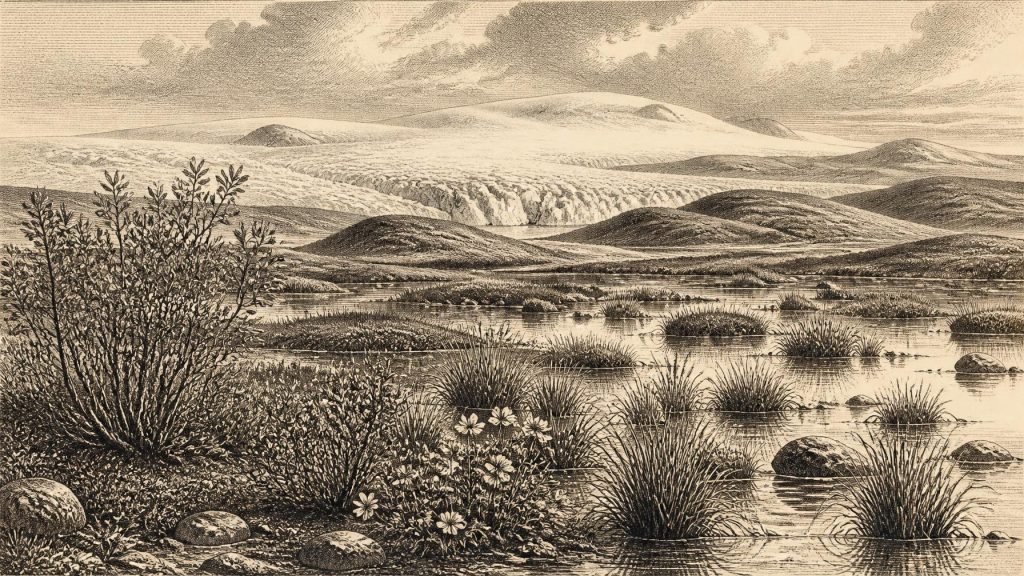
The plant record points to open, treeless country around the wetland rather than forest. Mosses, sedges, grasses and hardy herbs are represented, alongside plants associated with cold conditions, including mountain-avens (Dryas octopetala), dwarf willow, juniper, lesser clubmoss and bogbean. Some were plants of damp ground or shallow water; others suggest exposed, often calcareous or disturbed terrain nearby. This was not a simple modern tundra transplanted to Ireland. It was a changing cold-stage mosaic: shallow pools, sedge-rich wet places, patches of low vegetation and more exposed ground, shaped by frost, wind, runoff and the proximity of ice.
The environmental evidence is local, not a complete map of the island. Derryvree cannot prove that all regions of Ireland shared the same vegetation, nor that conditions remained stable for centuries. It does, however, demonstrate that at least one northern locality could support freshwater life and plant communities during an interval between glacial advances. In an era for which later ice sheets destroyed or reworked much older evidence, such a sealed deposit is exceptionally valuable.
An Uneven Ice-Age Ireland
Ireland around this broad period was not yet necessarily an island in the familiar modern sense. Sea level was markedly lower than today, changing the extent of coastal plains and narrowing or altering water crossings around the Irish Sea. Yet lower sea level did not automatically create an easy, continuous land bridge from Ireland to Britain or continental Europe. Routes would have depended on shifting coastlines, channels, ice margins, river systems and the season. The evidence does not allow a confident reconstruction of one route, one shoreline or one migration corridor for 30,829 BCE.
Nor was the Irish Ice Sheet a fixed white cap. Modern reconstructions of the British–Irish Ice Sheet begin at about 31,000 years ago because earlier constraints are sparse. Their preferred models show ice accumulation in northern Ireland and on several Irish uplands, while also stressing large uncertainties in where margins lay at individual times. By about 30,000 years ago, ice was advancing over northern and central Ireland in some reconstructions, while south-western Ireland may have supported smaller upland ice masses. The great maximum of the last ice sheet came later, principally around 25,000–23,000 years ago. The numbered year in this article therefore belongs to an unstable pre-maximum landscape, in which ice, periglacial ground and habitable open zones could coexist across different regions.
This instability mattered more than any imagined political boundary. Freeze-thaw action fractured rock; seasonal meltwater moved sediment; winds and sparse vegetation exposed soil. Ice and water repeatedly modified the topography whose drumlins, valleys, eskers and wetlands would become defining features of the later Irish landscape. The processes were geological, but they set the limits within which animals, and perhaps occasional people, could move.
Castlepook’s Animal World
The best-known southern Irish window is Castlepook Cave, also called Mammoth Cave, near Doneraile in north County Cork. Its cave deposits and old collections have produced one of Ireland’s richest Pleistocene faunal assemblages. Woolly mammoth, reindeer, giant deer, brown bear, spotted hyaena, wolf, Arctic fox, hare and lemmings are among the animals represented in the wider Castlepook record. The collection does not mean that every species stood together on the valley floor in the same year. Cave deposits may gather bones over long spans; carnivores can carry prey remains into dens; water, collapse, excavation and later disturbance can mix materials. Each specimen must be dated and interpreted on its own merits.
Nevertheless, the fauna securely establishes that Ireland could sustain a varied cold-stage mammal community during MIS 3. Reindeer and lemmings indicate northern, open-habitat conditions. Mammoth, horse and giant deer belong to the wider grazing landscapes often described as mammoth-steppe or steppe-tundra, though that phrase should not conceal local variation in wetland, grassland, herb-rich ground and bare substrate. Spotted hyaena is particularly significant: Castlepook is Ireland’s key site for the species, and hyaenas could both hunt and scavenge, altering the bone assemblage. Their presence speaks to a functioning food web with substantial herbivores and predators, rather than an empty or uniformly frozen land.
The animals also reveal regional change. Later redating of bones from Castlepook, Foley Cave and Shandon Cave showed that several earlier radiocarbon results had been too young, sometimes by thousands of years. That revision pushed parts of Ireland’s MIS 3 fauna farther back in time and suggests that giant deer and spotted hyaena may have disappeared locally before the Last Glacial Maximum. The lesson is methodological as much as historical: the Irish Ice Age record has been repeatedly revised as accelerator mass spectrometry, collagen pretreatment and calibration have improved.
A Possible Human Trace
A fragment of reindeer femur from Castlepook has attracted exceptional attention because it has been reported as bearing marks consistent with stone-tool butchery and was dated at approximately 33,000 years ago. If the marks are confirmed as anthropogenic and contemporary with the bone’s use, they would indicate that people processed a reindeer carcass in Ireland during this earlier Ice Age phase. That would be far older than the widely accepted terminal-Pleistocene evidence from Alice and Gwendoline Cave in County Clare, where a butchered brown-bear kneecap has calibrated dates around 12,810–12,590 years BP.
But Castlepook does not yet justify a story of a settled Irish population in 30,829 BCE. The femur comes from a complex cave record disturbed by early excavations, and the relevant interpretation rests on a very small body of material rather than hearths, stone-tool assemblages, dwellings, burials or a securely stratified occupation surface. A marked bone can indicate a brief visit, a hunt, carcass processing away from a camp, or a sequence of events not presently recoverable. The evidence supports the possibility of a human presence; it does not demonstrate a village, a permanent colony or a continuous population.
What Society Cannot Yet Be Seen
For this reason, conventional headings such as politics, diplomacy, warfare, religion, learning, trade and government must be treated plainly: there is no direct Irish evidence for any of them at this date. No chiefs, peoples, languages, territories, alliances, shrines or named places can responsibly be supplied. Nor can archaeology identify a market economy or regular overseas trade. The words themselves belong to much later forms of evidence and would falsely suggest a documented society.
If people did reach Ireland during this interval, they would have required substantial practical knowledge: how to cross or negotiate the changing western edge of north-west Europe, read seasonal animal movement, make and maintain tools, obtain fuel and shelter, process food, and manage cold exposure. These are reasonable inferences from Upper Palaeolithic lifeways elsewhere, not discoveries from an Irish campsite. The same distinction applies to culture and belief. Mobile hunter-gatherers elsewhere possessed social relationships, skills, stories and symbolic practices, but no Irish object or feature currently reveals their equivalents at this time.
The strongest account of Ireland around 30,829 BCE is therefore an environmental and evidential one. A Fermanagh wetland, preserved between tills, records resilient plants in an open cold landscape. Cave deposits in Cork record mammals ranging from reindeer to mammoth and hyaena. Glacial reconstructions show that ice was growing and moving unevenly, while later advances would erase much of what had existed. One reindeer femur offers a challenging, potentially transformative indication of human action, but not yet a settled human history. The silence is not an empty page: it is the defining fact of this remote Irish past, and the reason the surviving mosses, bones, silts and ice-shaped ground deserve such close attention.
Primary Sources
- A reconsideration of the radiocarbon dating of the Marine Isotope Stage 3 fauna from southern Ireland
- The Irish Quaternary Fauna Project
- The IntCal20 Northern Hemisphere radiocarbon age calibration curve (0–55 kcal BP)
- Growth and retreat of the last British–Irish Ice Sheet, 31,000 to 15,000 years ago: the BRITICE-CHRONO reconstruction
- Last Glacial Maximum cirque glaciation in Ireland and implications for reconstructions of the Irish Ice Sheet
- Dimensions and chronology of the last ice sheet in Western Ireland
- Stratigraphic and palaeo-geomorphological evidence for the glacial-deglacial history of the last British-Irish Ice Sheet in the north-western Irish Sea
- The colonization of Ireland: A human ecology perspective
- First evidence of a Late Upper Palaeolithic human presence in Ireland
- New insights on the fauna of Ireland’s Younger Dryas and Early Holocene from Alice & Gwendoline Cave
- Figure 6.— The subdivision of the Quaternary Period in Ireland
- Introduction to the Late Quaternary and Holocene of Northern Ireland
- Soils of County Waterford
- Dryas octopetala
- Castlepook Caves
- 32564 – Castlepook Cave, Co. Cork
- Heritage Artefacts of County Cork
- Ireland through geological time
- Geology of Ireland
- Reconstructing the last Irish Ice Sheet 2: a geomorphologically-driven model of ice sheet growth, retreat and dynamics
