Cork’s Mammoth Cave Fauna30785 BCE
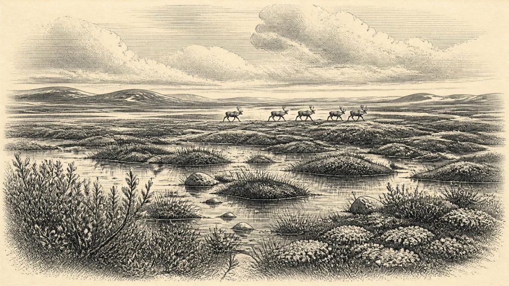
Around 30,785 BCE, Ireland lay within the Late Pleistocene MIS 3 cold phase, before the Last Glacial Maximum. Evidence from Derryvree, County Fermanagh, records an ice-free, treeless wetland of sedges, shallow water and cold-adapted plants, later overridden by ice. Castlepook Cave in north County Cork contains a long, disturbed accumulation of mammoth, giant deer, reindeer, hyaena and other fauna, demonstrating episodic animal movement through open tundra-steppe landscapes. Lower sea levels may have aided access from neighbouring lands. A possibly butchered reindeer bone suggests human visits, but no occupation evidence exists. Environmental change, advancing ice and fragmentary deposits define this period.
Dateline
A Modern Year in Deep Time
30,785 BCE is a modern chronological label, not a year that anyone in Ireland could have named or recorded. In simple calendrical arithmetic it falls about 32,734 years before AD 1950, the conventional “present” used in radiocarbon reporting. That apparent precision is misleading. No written record, settlement sequence or securely dated event permits Irish history to be reconstructed at the scale of a single year this far back. The responsible view is therefore regional and chronological: this point lies in the Late Pleistocene, broadly within Marine Isotope Stage 3 (MIS 3), during the long and uneven deterioration that preceded the Last Glacial Maximum.
Even the principal scientific chronologies are ranges rather than dates on a calendar. A freshwater deposit at Derryvree near Maguiresbridge, County Fermanagh, produced the conventional radiocarbon determination Birm-166, 30,500 ± 1,100 radiocarbon years BP. Subsequent discussion gives a calibrated range of roughly 31.7–36.9 thousand calendar years BP for the organic material. This is valuable evidence for an ice-free episode in part of Ireland, but it cannot identify conditions in every district, nor establish what happened in 30,785 BCE itself. Castlepook Cave, near Doneraile in north County Cork, likewise preserves animal remains dating across a very long span, not a single contemporaneous episode.
The picture is consequently one of moving ice margins, exposed ground, cold wetlands, caves and travelling animals. It is not a picture of an Irish people, kingdom or nation. The island’s archaeological record at this depth is fragmentary, and it is the physical environment rather than human institutions that can be described with confidence.
Before the Ice Sheet’s Maximum
Ireland was approaching, but had not yet reached, the fullest extent of the last British–Irish Ice Sheet. The globally defined Last Glacial Maximum is commonly placed at about 26.5–19 thousand years BP. Work on the Atlantic shelf west of Ireland indicates that grounded ice reached its maximum offshore position around 26.8 ± 1.33 thousand years BP, with retreat under way by about 25.9 ± 1.8 thousand years BP. Those later figures demonstrate the scale of the transformation to come; they should not be projected backwards to imply that all Ireland was already buried under a uniform ice sheet at the date considered here.
Recent syntheses instead stress uncertainty and regional variation before the maximum. There is evidence for earlier ice-sheet growth, movement and retreat during MIS 3, but the timing and extent of individual advances remain debated because directly dated tills are scarce. The Derryvree organic beds are important precisely because they interrupt the story told by glacial sediments: freshwater silts and fine sands lay between two distinct tills in a drumlin cut by roadworks in 1969. At the time the sediments accumulated, that locality was not beneath glacier ice. Later ice overrode and sealed the deposit, preserving an exceptionally rare glimpse of a pre-maximum Irish landscape.
The sea also did not make Ireland an island in the modern sense throughout this period. Global sea level was much lower than today because vast quantities of water were locked in northern ice sheets. The Irish Sea basin and continental shelves had very different coastlines and land–sea connections, although their precise form changed through time. Such lowered seas made animal movement between Ireland and neighbouring landmasses more feasible at some intervals. They do not, however, prove a particular route, season or human crossing in this particular year.
Derryvree’s Cold Wetland
The Derryvree sequence offers the clearest environmental evidence relevant to the broad period. Its fossil pollen, plant remains and mosses indicate an open, treeless setting, often described as tundra or muskeg: wet, peaty ground with shallow freshwater, sedges and cold-adapted vegetation. Finds include remains attributed to dwarf birch, dwarf willow, mountain avens, bogbean, water-milfoil, clubmosses and a notable moss flora. Taken together, they suggest a mosaic rather than a featureless frozen plain: pools and marshy hollows, mineral ground, sedge-rich wetland and sparse vegetation able to tolerate severe winters.
That evidence must be read carefully. Plant macrofossils and pollen show what grew in or reached a particular basin; they do not supply a panoramic photograph of all Fermanagh, much less all Ireland. Nor is the Derryvree deposit a proof of a stable benign interval. Its cold-stage flora points to a landscape with short growing seasons and conditions unlike the wooded island of recent millennia. The important conclusion is modest but substantial: parts of Ireland could support freshwater habitats and cold-adapted plant communities during an interval later engulfed by ice.
These wetlands mattered ecologically. Water, sedges and other vegetation sustained insects and small animals, while open country provided grazing or browsing opportunities for larger mammals. Yet the evidence does not allow a reconstruction of particular herds at Derryvree, and it certainly does not demonstrate hunting there. The deposit is an environmental archive, not a campsite.
The Cave Record in North Cork
For animal life, Castlepook Cave—also known as Mammoth Cave or Doneraile Cave—is central. Formed in Carboniferous limestone near Doneraile, its narrow galleries and larger chambers, including Elephant Hall and Hyena Hall, yielded more than 2,000 bones during excavations conducted chiefly between 1904 and 1918. Geological Survey Ireland describes it as Ireland’s richest known site for vertebrate fauna in the period leading towards the Last Glacial Maximum. Direct dates on individual remains range broadly from about 45,700 to 19,950 years BP.
The assemblage includes woolly mammoth, giant deer, reindeer, brown bear, spotted hyaena, wolf, Arctic fox and lemmings. It reveals that Ireland was periodically part of a north-west European cold-stage animal world, not an empty frozen outpost. Reindeer, in particular, suit the image of open, productive tundra-steppe terrain; mammoth and giant deer indicate that sizeable herbivores reached the island; predators and scavengers show that food webs were complex. But the list must not be made into an imaginary scene in which every animal stood together outside the cave in the same season. The bones derive from different episodes, and the cave’s deposits were disturbed by water, carnivore activity and early excavations.
Spotted hyaenas are especially important to interpretation. A cave rich in bones is not automatically a human hunting station. Hyaenas could accumulate, gnaw and redistribute carcass remains, while natural deaths, transport by water and later disturbance add further complications. Castlepook’s value lies not only in its dramatic fauna but also in the caution it imposes: deposits must be dated specimen by specimen and read in relation to their geological context.
The Question of People
A reindeer femur from Castlepook has been publicised as bearing a deep mark interpreted as made while butchering with a stone tool, and as being approximately 33,000 years old. If future research securely confirms both the mark’s human origin and its association with the dated bone, it would be evidence for an Upper Palaeolithic visit to Ireland far earlier than the long-accepted record of substantial settlement after the Ice Age. It would imply small, mobile groups capable of reaching and exploiting a difficult northern landscape.
That is not yet a licence to populate Ireland with a permanent community. No securely excavated hearth, dwelling, tool assemblage, burial ground or intact occupation layer has been demonstrated for the island at this date. Modern re-investigation at Castlepook has sought surviving Pleistocene deposits precisely because the antiquarian excavations removed much of the original context. The most careful conclusion for 30,785 BCE is that human presence remains possible, perhaps even increasingly plausible, but unproven as a settled or continuous occupation.
Accordingly, there is no evidence from which to write of political authority, diplomacy, warfare, named leaders, laws or territorial boundaries. There is equally no direct evidence for religion, formal ritual, visual art, language, learning or exchange networks in Ireland at this moment. The absence is archaeological, not a claim that any visitors lacked beliefs, speech or social ties. It means only that the surviving Irish record cannot responsibly recover them.
Life, Movement and Limits
If people did enter Ireland during this wider interval, their economy would have been based on hunting, gathering and careful movement through a seasonal landscape, rather than farming, herding, metalworking or trade in the later prehistoric sense. They would have needed knowledge of animal behaviour, weather, fuel, stone and safe routes. Such observations are reasonable inferences from Upper Palaeolithic lifeways elsewhere in north-west Europe, not facts demonstrated by an Irish campsite. No artefact assemblage presently permits a distinctive Irish technology or cultural group to be identified.
Settlement, too, must be described negatively. The Derryvree wetland shows habitable ecological niches, while Castlepook demonstrates animal colonisation and the usefulness of caves as traps or repositories for evidence. Neither establishes a village, a domestic cave occupation or a resident population. Conditions were unstable on the longer timescale: climatic shifts altered vegetation, ice margins and coastlines, and the advance towards the maximum would eventually erase or bury much evidence. Any human visits may therefore have been brief and episodic, leaving traces difficult to distinguish from natural processes.
The chief historical development around this nominal year was environmental change. Ireland contained, at least in some phases and regions, open cold landscapes supporting plants and large mammals; it also lay within an increasingly glacial North Atlantic world. Soon afterwards, on the scale of millennia, the last ice sheet expanded towards its maximum extent and profoundly reshaped the island. Drumlins, tills, scoured bedrock and offshore moraines are part of that legacy. The bones in Cork and the organic silt beneath a Fermanagh drumlin preserve the more fleeting world before it: not a dated episode of Irish national history, but a hard-won record of life at the edge of advancing ice.
Primary Sources
- A Middle Midlandian Freshwater Series at Derryvree, Maguiresbridge, County Fermanagh, Northern Ireland
- The Irish Quaternary Fauna Project
- Castlepook Cave, County Geological Site Report
- 2022:564 — Castlepook Cave, Castlepook South, Cork
- Archaeology Research Excavation Grant 2022: Final Report
- Prehistoric Details: Stone Age
- Extent and Timing of the Last Glacial Maximum in Britain and Ireland: A Review
- Pattern and Timing of Retreat of the Last British-Irish Ice Sheet
- The Timing and Magnitude of the British–Irish Ice Sheet Between Marine Isotope Stages 5d and 2
- Timing and Pace of Ice-Sheet Withdrawal Across the Marine–Terrestrial Transition West of Ireland During the Last Glaciation
- Oscillating Retreat of the Last British-Irish Ice Sheet on the Continental Shelf Offshore Galway Bay, Western Ireland
- The Deglaciation of the Western Sector of the Irish Ice Sheet From the Inner Continental Shelf to its Terrestrial Margin
- Last Glacial Maximum Cirque Glaciation in Ireland and Implications for Reconstructions of the Irish Ice Sheet
- Trimlines, Blockfields and the Vertical Extent of the Last Ice Sheet in Southern Ireland
- New Insights on the Fauna of Ireland's Younger Dryas and Early Holocene From Alice & Gwendoline Cave
- The Archaeology of Caves in Ireland
- North of Ireland: Field Guide
- Regional Pleistocene Geology
- The Mesolithic in Ireland: When Was It?
- Dimensions and Chronology of the Last Ice Sheet in Western Ireland
- New Data for the Last Glacial Maximum in Great Britain and Ireland
- Lateglacial Vegetation and Environment in Ireland: First Results From Four Western Sites
