
BIRM-166’s Moss Bed30697 BCE
The modern label 30,697 BCE denotes a broad Late Pleistocene interval, not a precisely recoverable Irish year. At Derryvree, County Fermanagh, BIRM-166 organic mud between glacial tills records an ice-free freshwater wetland before renewed glaciation. Radiocarbon evidence places it broadly around 36,900–31,700 cal BP. Mosses, sedges, bogbean and mountain-avens indicate cold, open tundra-like conditions, while Ireland experienced variable ice growth and North Atlantic climate shifts. Cave fauna show Ice Age animals ranged across Ireland. A marked reindeer bone from Castlepook may indicate butchery, but cannot establish settlement. No political, social or cultural history is recoverable; environmental change remains the evidence.
Dateline
30,697 BCE is a modern calendar label, not a date that can be recovered with annual precision from prehistoric Ireland. No written calendar, named community or dated event survives from this depth of time. In archaeological terms, the label falls roughly 32,650 years before AD 1950, in the Late Pleistocene, during Marine Isotope Stage 3. The responsible history of Ireland at this point is therefore a history of deposits, plants, animal bones, ice and changing environments—not rulers, wars or recorded migrations. Radiocarbon ages also require calibration because atmospheric carbon-14 has varied over time; at more than 30,000 years ago the resulting calendar estimates are broad ranges, rather than a particular year.
A Wetland Beneath a Drumlin
The most informative Irish evidence for this broad period comes from Derryvree, near Maguiresbridge in County Fermanagh. Roadworks in 1969 cut through a drumlin and revealed a remarkable sequence: two substantial sheets of glacial till, separated by freshwater silts, fine sands and organic mud. The order of those layers matters. An earlier glacier had deposited the lower till; then an interval without local ice allowed water, sediment, plants and small animals to occupy a basin; finally, renewed glaciation buried the wetland below another till sheet. The deposit was preserved not because it was a settlement, but because ice later sealed it.
Organic material from this middle layer, laboratory sample BIRM-166, produced a conventional radiocarbon determination of 30,500 years BP, with an uncertainty of +1,170 and −1,030 years. Subsequent discussion places the evidence within a broad calibrated range of about 36,900–31,700 cal BP, approximately 34,950–29,750 BCE. The assigned year lies within that range, but no individual plant, animal, season or human action can be attached to it. Derryvree consequently illuminates a long environmental interval, not a moment in a chronicle. Its date and stratigraphy do, however, securely show that north-central Ireland contained at least one ice-free freshwater landscape before later ice expansion.
Cold Water and Open Ground
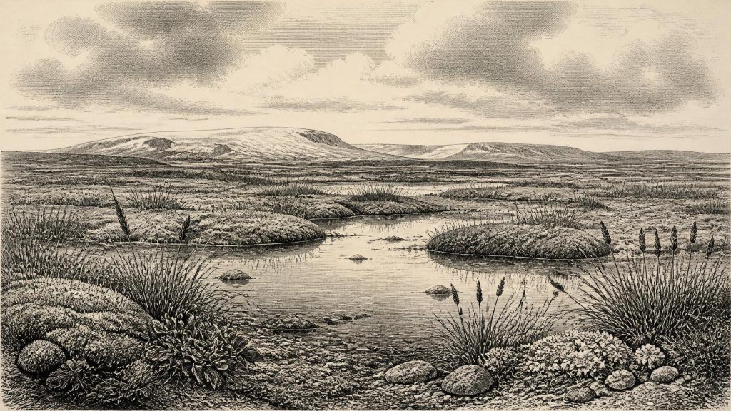
The Derryvree fossils indicate an open, treeless and periglacial environment. The original investigators described a flora and fauna of full-glacial character and concluded that tundra vegetation prevailed. Moss-rich muds, sedges, grasses and aquatic or wet-ground plants show that this was not a lifeless white expanse. It was a working wetland: water lay or moved slowly through a shallow basin, plant matter accumulated in silt, and patches of moss and sedge occupied saturated ground. Finds associated with the deposit include bogbean (Menyanthes trifoliata) and mountain-avens (Dryas octopetala), plants well suited to cold and exposed conditions.
“Tundra” should nevertheless be used carefully. It is an ecological reconstruction from plant remains, insects, sediments and the known requirements of comparable species; it is not a photograph of every part of Ireland in one year. Derryvree represents a local basin near present-day Maguiresbridge. It cannot prove that every valley, coast or upland was simultaneously ice-free, equally wet or covered in identical vegetation. Nor does it permit a precise temperature figure for 30,697 BCE. What it demonstrates is more valuable and more secure: a cold, exposed, freshwater habitat persisted locally during a fluctuating phase of the last glacial cycle.
An Island in Transition
Ireland’s wider setting was unstable. The British–Irish Ice Sheet had not yet reached the later maximum extent associated with the Last Glacial Maximum, but it was developing in a climate system marked by abrupt North Atlantic shifts. Recent reconstructions stress that ice growth and maximum extent were asynchronous across Ireland and its surrounding shelf: some sectors advanced earlier or farther than others. The Derryvree sequence is a warning against imagining either a permanently ice-covered island or a uniformly habitable one. Local ice-free ground, growing ice masses and changing sea levels could coexist within the same broad millennia.
Evidence from Crag Cave in south-west Ireland adds another indication of instability. There, episodes of speleothem growth during the last glacial period required liquid water and conditions sufficiently mild for cave calcite to form. The chronology of these episodes broadly corresponds with Greenland interstadials, showing that Ireland’s climate responded to wider North Atlantic oscillations. This does not make Derryvree a direct record of a specific Greenland event, but it supports the larger interpretation of Marine Isotope Stage 3 as a period of repeated environmental change rather than one unbroken freeze.
Caves and Ice-Age Animals
Southern Irish caves supply a complementary, though more complicated, record. Castlepook Cave near Doneraile in County Cork—also called Mammoth Cave—yielded a substantial Pleistocene assemblage during early twentieth-century excavation. Its collections include remains of animals associated with cold-stage landscapes, among them reindeer, giant deer, woolly mammoth, spotted hyaena, wolf, fox and smaller mammals. Across Ireland, the Quaternary faunal record indicates that a wider range of mammals entered the island between at least 45,000 and 20,000 years ago, although individual cave assemblages often combine material accumulated, moved or disturbed at different times.
These animals should not be arranged into an invented scene at Derryvree in this exact year. The cave evidence is geographically distant, and its chronology is uneven. It does establish, however, that Ireland formed part of the far north-western range of Ice Age animal movements during the broader period. Herbivores could exploit open vegetation; carnivores and scavengers used caves and moved bone. Cave deposits are especially difficult evidence because water, animal activity, collapse and antiquarian excavation may all mix material. Modern excavation and re-dating programmes at Castlepook are therefore important precisely because they test the old collections rather than treating them as simple, undisturbed snapshots.
A Possible Human Trace
One Castlepook object is especially provocative: a reindeer femur, held in the National Museum of Ireland’s Natural History collections, bears a deep mark interpreted by zooarchaeologist Ruth Carden as damage made by a sharp stone tool during butchery. County Cork’s heritage publication assigns the bone broadly to about 31,000 BC. If that interpretation and association are confirmed, it would suggest that people processed a reindeer in Ireland during the broad period considered here—far earlier than the better-established terminal Pleistocene evidence from County Clare.
The limitations are as important as the possibility. The femur is not from a newly excavated, sealed camp floor. No securely associated stone-tool assemblage, hearth, dwelling, burial, food store or repeated occupation surface of comparable age has been found at Castlepook. The bone’s date is the age of the animal, while interpretation of the incision depends on taphonomic analysis of how marks form on fresh and weathered bone. The responsible conclusion is therefore modest: the specimen may preserve evidence of human carcass processing, but it does not prove a permanent population, a named culture, a settlement at the cave or an unbroken ancestry leading to later inhabitants of Ireland.
The contrast with the later evidence is useful. A butchered brown-bear patella from Alice and Gwendoline Cave, County Clare, has two calibrated determinations between about 12,810 and 12,590 cal BP and is widely presented as evidence for a Late Upper Palaeolithic human presence. Even there, the evidence speaks to limited activity rather than a fully documented society. At 30,697 BCE, the human case is much more tentative, and must remain secondary to the securely attested environmental record.
What Cannot Be Recovered
There is no evidence for political affairs, diplomacy, organised warfare, kingdoms, ethnicity, named languages, religion, formal learning or trade networks in Ireland at this date. Nor can archaeologists identify an Irish household, farm, grave, shrine, field system or village. If small groups of Upper Palaeolithic hunters entered the island, comparisons with contemporaneous communities elsewhere in north-west Europe might suggest mobility, stone technology and reliance on seasonally available resources. But that is contextual inference, not a demonstrated account of life in Ireland. The archaeological record does not justify filling its silences with imagined chiefs, rituals or migrations.
The best-supported “economy” was ecological rather than human: wetland plants grew and decayed; herbivores fed in open country; predators and scavengers moved carcasses; water sorted sediments; and advancing ice periodically erased, reshaped or entombed the terrain. The most consequential regional development was the changing relation between ice-free refuges and expanding glacier ice. Derryvree’s moss bed survived as a rare archive because the later landscape buried it. Around the modern label 30,697 BCE, Ireland was cold, open, regionally variable and environmentally connected to the wider North Atlantic world—while its human history, if there was one, remains almost entirely beyond recovery.
Primary Sources
- A Middle Midlandian Freshwater Series at Derryvree, Maguiresbridge, County Fermanagh, Northern Ireland
- Exploring Controls of the Early and Stepped Deglaciation on the Western Margin of the British-Irish Ice Sheet
- Growth and Retreat of the Last British–Irish Ice Sheet, 31,000 to 15,000 Years Ago: The BRITICE-CHRONO Reconstruction
- The Timing and Magnitude of the British–Irish Ice Sheet Between Marine Isotope Stages 5d and 2
- Character of Advance and Retreat of the Southwest Sector of the British-Irish Ice Sheet During the Last Glaciation
- Episodic Speleothem Deposition Tracks the Terrestrial Impact of Millennial-Scale Last Glacial Climate Variability in SW Ireland
- The Irish Quaternary Fauna Project
- New Insights on the Fauna of Ireland's Younger Dryas and Early Holocene from Alice & Gwendoline Cave
- First Evidence of a Late Upper Palaeolithic Human Presence in Ireland
- Heritage Artefacts of County Cork
- Castlepook Cave, Co. Cork: 2022 Excavation Report
- Archaeology Research Excavation Grant 2022: Castlepook Cave Final Report
- Occurrence of Mammalia Relicts at Site Castlepook Cave
- Mammoth Cave / Castlepook Cave
- Quaternary Data and Maps
- The Subdivision of the Quaternary Period in Ireland
- Menyanthes trifoliata L.
- Dryas octopetala L.
- The IntCal20 Northern Hemisphere Radiocarbon Age Calibration Curve (0–55 cal kBP)
- IntCal Publications
- A 60,000 Year Greenland Stratigraphic Ice Core Chronology
- Irish Quaternary Association