
Threeleaf Seed Beneath Fermanagh30531 BCE
Around 30,531 BCE, Ireland lay within the climatically unstable Late Pleistocene, not a documented historical year. At Derryvree, County Fermanagh, freshwater silts between glacial tills preserve evidence of an ice-free interval, with tundra-like vegetation including bogbean, sedges, mosses and cold-tolerant plants. Later ice buried or disturbed much earlier evidence. Castlepook Cave, County Cork, yielded remains of mammoth, reindeer, giant deer, predators and small Arctic-adapted mammals, demonstrating an Ice Age ecosystem. A marked reindeer bone may indicate brief Upper Palaeolithic human activity, but no secure settlement evidence exists. Ireland’s changing ice, habitats and uncertain connections profoundly shaped this poorly recoverable period.
Dateline
30,531 BCE is a modern chronological label, not a year that anybody in Ireland could have counted, named or recorded. Modern calendar-year precision is not available at this depth of time. The useful setting is the Late Pleistocene, within Marine Isotope Stage 3 (MIS 3), a long and climatically volatile part of the last Ice Age. The closest Irish evidence is measured in broad calibrated ranges, not in individual years: buried freshwater sediments, cave faunas, glacier deposits and a handful of radiocarbon determinations. Together they illuminate an island of open, cold habitats and changing ice margins, not a society with known leaders, settlements or events.
A Date Within a Wide Range
The notional date falls about 32,481 years before AD 1950, the conventional “present” used in radiocarbon dating. That arithmetic does not make it a recoverable historical moment. A radiocarbon measurement is not a calendar date because atmospheric carbon-14 levels have varied over time. Results must be calibrated against independent records, and uncertainty increases markedly so far back in time. IntCal20, the principal Northern Hemisphere calibration curve, reaches to 55,000 calendar years before present, but its purpose is to provide probability ranges rather than false annual precision.
Ireland’s most relevant dated environmental archive is Derryvree, near Maguiresbridge in County Fermanagh. Road works in 1969 exposed a drumlin cut by two substantial layers of till: unsorted sediment deposited by glacier ice. Between them lay fine sands and organic silts, accumulated during an interval when freshwater and ground vegetation existed locally. Organic material from this layer, laboratory sample BIRM-166, returned a conventional age of 30,500 radiocarbon years BP, with a large uncertainty of +1,170/−1,030 years. Later calibration and modelling place it broadly in the mid-thirty-thousand years before present; published treatments give a range wide enough to encompass 30,531 BCE. The deposit is therefore an excellent guide to the period, but not proof of conditions on one particular year, season or day.
A Wetland Between Ice Advances
Derryvree’s value lies in its stratigraphy. The lower till shows that glacier ice had previously occupied the locality. The freshwater silts and sands demonstrate a subsequent interval in which a basin or wet ground could collect sediment and organic remains. The upper till records later renewed glacial influence. This sequence establishes environmental change over millennia. It does not tell us whether the later ice reached the site in a single rapid advance, nor whether every part of Ireland followed the same sequence at the same time.
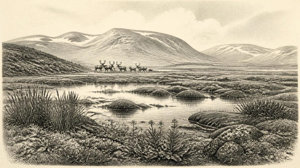
The fossils nevertheless make the landscape more tangible. Pollen, plant macrofossils, mosses and insects indicate open tundra-like ground under periglacial conditions. Sedges, mosses and aquatic plants occurred beside cold freshwater; a fossil seed of bogbean, Menyanthes trifoliata, is among the memorable finds. Dwarf willow, mountain avens and other Arctic-alpine or cold-tolerant elements help to explain why older accounts called this a treeless “muskeg” environment. “Tundra” is an interpretation built from this assemblage, not a claim that the entire island resembled one uniform modern Arctic landscape. Local water, shelter, soil and snow cover would have produced varied microhabitats.
There were no forests of the sort associated with later prehistoric Ireland. Open ground would have exposed plants and animals to wind, frost and strong seasonality, while pools, sedge beds and mossy margins offered more productive patches. The evidence supports a landscape capable of sustaining plants, insects and grazing animals during an ice-free interval in Fermanagh. It does not provide a thermometer reading, an annual rainfall total or a complete map of vegetation across the island.
Before the Greatest Ice Expansion
This was before the fullest development of the Last Glacial Maximum, conventionally dated in Ireland and the wider British–Irish Ice Sheet system to roughly 26,000–19,000 years ago, though advances and ice thickness differed between regions. Around the period represented by Derryvree, climatic fluctuations and accumulating ice were already fundamental forces in Irish history. Ice had shaped valleys and lowlands before the freshwater phase, and later ice either advanced across, or left deposits over, the Fermanagh basin. Much of the older terrain and archaeology that might once have existed was subsequently eroded, buried or disturbed.
It is consequently wrong to imagine a fixed coastline or an immutable island. Sea level was lower than today because water was stored in global ice sheets, while the geography of Britain, Ireland and the surrounding shelf changed repeatedly. Animal remains demonstrate that large mammals reached Ireland at intervals, but they do not identify a single route or prove that a dry land bridge existed at this exact time. Animals and, potentially, people could have moved through a shifting north-west European landscape by routes that remain uncertain. The responsible conclusion is connectivity at some point, not a confidently drawn road across the sea.
The Castlepook Animal World
The other major Irish archive is Castlepook Cave, also called Mammoth Cave, near Doneraile in north County Cork. Excavations and old collections from the cave have produced Ireland’s richest known assemblage of vertebrate remains from the last cold stage. Woolly mammoth, reindeer, giant deer, brown bear, wolf, Arctic fox, mountain hare, collared lemming, Norway lemming and spotted hyaena all feature in the wider Castlepook record. The National Museum of Ireland identifies the cave as the country’s most important site for mammal remains from this cold stage.
These finds establish that Ireland was part of a functioning Ice Age food web. Grazing and browsing mammals could exploit open habitats; predators and scavengers followed them; small cold-adapted mammals occupied their own ecological niches. Yet a cave bone assemblage is not a census of animals living together in one valley in 30,531 BCE. Bones may have been brought in by carnivores, water, people or natural processes, and many came from excavations undertaken before modern standards of recording. Improved radiocarbon pretreatment has already shown that several earlier Irish cave dates were too young. Castlepook is powerful evidence, but it must be read critically, specimen by specimen.
A Possible Human Trace
The most intriguing human question concerns a reindeer femur from Castlepook, publicly reported as approximately 33,000 years old and bearing a deep mark interpreted by palaeozoologist Ruth Carden as a cut or chopping trace made with a sharp stone tool. If that interpretation and its chronological association are sustained, it may indicate that one or more Upper Palaeolithic people processed a reindeer carcass in Ireland during the broader period under discussion.
That possibility should not be inflated into a settled population. The bone was recovered from an older cave collection, rather than from a securely excavated occupation surface. No associated hearth, dwelling, stone-tool assemblage, burial, personal ornament or repeated activity area of comparable age has yet been demonstrated at Castlepook. The date belongs to the animal bone; it does not automatically date the mark, locate the kill or measure the duration of any visit. The evidence permits a carefully phrased possibility of brief human activity, not a claim for continuous habitation, a named people or an Irish Palaeolithic community.
Life Beyond the Evidence
Accordingly, political affairs, diplomacy and organised conflict cannot be reconstructed for Ireland at this point. There is no evidence for polities, chiefs, territorial boundaries, treaties or warfare. Nor is there evidence for farming, villages, monuments, formal religion, writing, teaching or trade networks on the island. To describe such institutions would be invention. If people did reach Ireland, comparative knowledge of Upper Palaeolithic Europe suggests small, mobile hunter-gatherer parties, reliant on portable equipment, shared knowledge and seasonal decisions. That is a reasonable regional analogy, but it is not a demonstrated social biography of Ireland.
The strongest historical development around 30,531 BCE was environmental instability. Water collected in a Fermanagh hollow long enough to preserve a remarkable botanical record; herds and predators ranged through open country in the south; ice later obscured or destroyed much of the evidence. Ireland was neither empty in an ecological sense nor securely known as a permanently inhabited human landscape. Its history at this date survives in a three-leaved bogbean seed, the bones of Ice Age animals, layers of mud, and the glacial clay that sealed them.
Primary Sources
- A Middle Midlandian Freshwater Series at Derryvree, Maguiresbridge, County Fermanagh, Northern Ireland
- A Reconsideration of the Radiocarbon Dating of the Marine Isotope Stage 3 Fauna from Southern Ireland
- The Irish Quaternary Fauna Project
- The IntCal20 Northern Hemisphere Radiocarbon Age Calibration Curve (0–55 cal kBP)
- IntCal Publications
- Exploring Controls of the Early and Stepped Deglaciation on the Western Margin of the British-Irish Ice Sheet
- Last Glacial Maximum Cirque Glaciation in Ireland and Implications for Reconstructions of the Irish Ice Sheet
- Trimlines, Blockfields and the Vertical Extent of the Last Ice Sheet in Southern Ireland
- Stratigraphic and Palaeo-Geomorphological Evidence for the Glacial-Deglacial History of the Last British-Irish Ice Sheet in the North-Western Irish Sea
- Geology of Ireland
- Castlepook Cave: County Geological Site Report
- Spotted Hyena Skull
- Quaternary Site Descriptions
- The Subdivision of the Quaternary Period in Ireland
- Heritage Artefacts of County Cork
- Castlepook Cave, Castlepook South, County Cork: Excavation Report 2022
- New Insights on the Fauna of Ireland’s Younger Dryas and Early Holocene from Alice & Gwendoline Cave
- First Evidence of a Late Upper Palaeolithic Human Presence in Ireland
- Menyanthes trifoliata: Fossil Record
- Learn About: The Ice Age
