
Crag Cave Flowstone Pulses30371 BCE
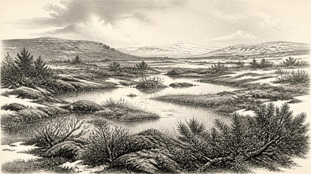
Around 30,371 BCE, Ireland lay within the unstable Late Pleistocene climate of Marine Isotope Stage 3, not a documented historical year. Derryvree, County Fermanagh, preserves freshwater sediments between glacial tills, indicating a cold, treeless tundra of wetlands, mosses, sedges and hardy plants during an ice-free interval. Kerry speleothems record rapid climatic fluctuations. Castlepook Cave fauna show recurring presence of reindeer, mammoth, giant deer, predators and other cold-adapted animals, though not necessarily together. A cut-marked reindeer bone may indicate brief human carcass processing, but cannot prove settlement. Later ice expansion reshaped and obscured these fragmentary landscapes across much of the island.
Dateline
“30,371 BCE” is a modern chronological label, not a year that can be recovered from an Irish calendar, chronicle or archaeological sequence. It corresponds roughly to 32,320 calendar years before AD 1950, the conventional reference point for “cal BP” dates. At this depth of time, even the best scientific evidence normally produces ranges of centuries or millennia, not an event in a particular twelve-month period. Ireland at this point belongs to the Late Pleistocene, broadly within Marine Isotope Stage 3: a volatile phase of the last Ice Age, before the later maximum expansion of the British–Irish Ice Sheet.
The most responsible account is therefore not a narrative of named people or happenings in 30,371 BCE. It is a reconstruction assembled from a small number of environmental archives: buried wetland sediments in County Fermanagh, cave-bone collections in County Cork, limestone deposits in County Kerry, glacial landforms on land and seabed, and the radiocarbon methods used to date them. These records reveal a cold, changing and intermittently habitable Ireland. They do not provide evidence for a state, tribe, village or historical individual.
Dating a Landscape, Not a Year
The closest Irish chronological anchor is the Derryvree freshwater sequence near Maguiresbridge, County Fermanagh. Roadworks in 1969 cut through a drumlin and exposed an exceptional layer-cake of Ice Age deposits. A lower sheet of till—unsorted material laid down directly by glacier ice—was overlain by fine sands, silts and organic-rich freshwater sediments. Another thick till capped the sequence. The order of these layers is decisive: ice had occupied the locality; afterwards, water and life accumulated in a hollow; later glacial activity buried and preserved that older landscape.
Organic material from the middle deposits, sample BIRM-166, gave a conventional radiocarbon age of 30,500 years BP, with a large reported uncertainty of plus 1,170 and minus 1,030 years. A radiocarbon age is not identical to a calendar age, because atmospheric carbon-14 concentrations have varied. Calibration using modern curves produces a broad probability range rather than an exact conversion; published reconstructions place the Derryvree evidence broadly in the later part of Marine Isotope Stage 3, with calibrated estimates extending approximately between 36,900 and 31,700 cal BP. The nominal year considered here may lie within that wide envelope, but cannot be made contemporaneous with the deposit in any precise sense.
That limitation is important. Derryvree does not tell us the weather on a particular day in 30,371 BCE, nor establish a single ice margin for the whole island. It does show that this part of Fermanagh experienced a non-glacial interval sufficiently long for freshwater sediments and a distinctive cold-climate ecosystem to develop between episodes of ice advance. The site is an environmental archive, not an archaeological settlement.
Open Tundra at Derryvree
The plant and animal remains in the Derryvree silts point to treeless open tundra and a periglacial regime: ground and water affected by severe cold in the vicinity of ice, rather than necessarily lying beneath it. Mosses, sedges, grasses, herbs, juniper, dwarf willow and aquatic plants formed a low, patchy vegetation. Fossils include bogbean (Menyanthes trifoliata), water-milfoil and mountain avens, plants that indicate wet ground, shallow or slow-moving freshwater and open, cold conditions. Insect evidence supports a moss-rich muskeg landscape: waterlogged terrain with pools, organic matter and vegetated margins.
This was not a blank white wilderness. During the growing season, sheltered hollows and wetland edges could be productive, even though winters were harsh and the wider landscape lacked woodland. The mixture of freshwater plants and tundra species suggests a mosaic rather than a uniform plain: shallow pools, sedge beds, mossy margins, gravelly ground and exposed slopes. Such environments could shift rapidly as temperature, snowfall, drainage and nearby ice changed. Their fragility helps explain why so little survives.
Evidence from Crag Cave in County Kerry reinforces the picture of instability. There, episodes of speleothem growth during the last glacial period indicate phases when liquid water was able to circulate through shallow cave systems. These Irish cave records broadly track abrupt North Atlantic climatic oscillations recorded in Greenland ice cores. They do not prove that Derryvree and Kerry had identical conditions at one moment, but they demonstrate that Ireland was sensitive to rapid shifts between colder and relatively milder intervals.
Before the Greatest Ice Expansion
The date falls before the best-documented maximum of the last British–Irish Ice Sheet. Recent syntheses place the most extensive ice cover around Ireland and its continental shelf principally between about 27,000 and 23,000 cal BP, although expansion, thickness and timing differed considerably from one sector to another. In later millennia, ice would cover the whole island and extend far across the western and southern shelves. Derryvree’s lower and upper tills are physical reminders that Irish landscapes could be invaded, abandoned and overridden again as that larger glacial system evolved.
Sea level was substantially lower than it is today because great volumes of water were locked in continental ice. Coastlines and shallow seas around Ireland consequently had different outlines, and exposed shelf landscapes may have altered routes available to animals and people. Yet lower sea level must not be turned automatically into a simple, continuous land bridge from Ireland to Britain or continental Europe. Deep channels, local ice, rough terrain, changing shorelines and season all mattered. The evidence supports ecological connections with north-west Europe; it does not map a safe crossing route in 30,371 BCE.
Castlepook’s Animal World
County Cork preserves a different kind of evidence. Castlepook Cave, near Doneraile—also known as Mammoth Cave—yielded one of Ireland’s richest Pleistocene faunal collections during early twentieth-century excavations. The wider assemblage includes reindeer, giant deer, woolly mammoth, brown bear, wolf, Arctic fox, mountain hare, lemmings and spotted hyaena. Together, these animals demonstrate that at intervals before the Last Glacial Maximum, parts of Ireland supported a much more varied large-mammal fauna than the modern island.
But Castlepook is not a snapshot of one community in one season. Cave deposits may combine animals from many periods and can be shaped by carnivore dens, scavenging, water movement, roof collapse and early excavation methods that did not record layers to modern standards. Improved radiocarbon pretreatment has also shown that some dates obtained in the 1990s for Irish cave material were too young. Castlepook is therefore best treated as evidence for recurring animal presence over a long span of the Late Pleistocene, rather than proof that every recorded species grazed together near Doneraile in 30,371 BCE.
Nevertheless, the ecological implication is substantial. Reindeer and lemmings fit cold, open country; mammoth and giant deer imply extensive feeding grounds during suitable phases; wolves and hyaenas indicate predators and scavengers exploiting large-herbivore carcasses. The Irish landscape was not yet the familiar green, wooded island of later millennia. It was a northern Ice Age environment whose animal populations probably expanded, contracted and moved with climate and access.
A Possible Human Trace
One Castlepook specimen gives this period exceptional historical interest: a reindeer femur reported as about 33,000 years old, bearing a deep mark interpreted by zooarchaeologist Ruth Carden as damage from a sharp stone tool during carcass processing. If that interpretation is correct and the mark was made while the bone was fresh, it is possible evidence that people handled a reindeer in Ireland during the Upper Palaeolithic, far earlier than the well-established post-glacial record of settlement.
The claim must remain narrowly stated. The femur came from an old cave collection, not a modern excavation of an intact occupation floor. It is not accompanied by securely associated hearths, stone tools, dwellings, burials, human remains or a concentrated butchered-animal assemblage of the same age. The radiocarbon result dates the animal’s bone, not independently the incision, the place of death, the duration of a visit or the identity of any visitor. At most, the specimen raises the strong possibility of brief human carcass processing; it does not demonstrate a permanent population, continuous occupation or an Irish hunting community.
What Cannot Be Reconstructed
There is no responsible evidence for political affairs in Ireland around this date: no rulers, territories, diplomacy, warfare, law, institutions or named communities. There is likewise no securely dated Irish evidence for houses, villages, monuments, formal burials, art, ritual places, language or learning. It would be misleading to import the spectacular art, stone industries and social networks of Upper Palaeolithic mainland Europe and present them as Irish facts.
The same restraint applies to economy and trade. If people did briefly reach Ireland, a reindeer carcass could potentially have supplied food, fat, hide, sinew, bone and antler. Those are plausible uses of an animal, not demonstrated products of an Irish economy. No quarry, tool workshop, exchange network, imported material or repeated seasonal camp is known from Ireland at this horizon. For the animals certainly present, survival depended on the basic economy of the landscape: forage, freshwater, shelter, seasonal movement and the pressures of predation and cold.
The principal development illuminated by 30,371 BCE is thus environmental. Derryvree records a cold freshwater and muskeg world between glacial episodes; Castlepook records repeated access by Ice Age mammals; and a marked reindeer bone leaves open the possibility of a fleeting human visit. In the following millennia, more extensive ice would erode, cover and rearrange many older surfaces. What remains is fragmentary, but it is enough to show that prehistoric Ireland was neither timeless nor empty: it was a changing northern landscape, briefly legible through mud, bone, water and ice.
Primary Sources
- Middle Midlandian Freshwater Series at Derryvree, Maguiresbridge, County Fermanagh, Northern Ireland
- Middle Midlandian Freshwater Series at Derryvree, Maguiresbridge, County Fermanagh, Northern Ireland
- Figure 6—The Subdivision of the Quaternary Period in Ireland
- Palaeoecology
- The IntCal20 Northern Hemisphere Radiocarbon Age Calibration Curve (0–55 cal kBP)
- Growth and Retreat of the Last British–Irish Ice Sheet, 31,000 to 15,000 Years Ago: The BRITICE-CHRONO Reconstruction
- Pattern and Timing of Retreat of the Last British-Irish Ice Sheet
- The Deglaciation of the Western Sector of the Irish Ice Sheet from the Inner Continental Shelf to its Terrestrial Margin
- Trimlines, Blockfields and the Vertical Extent of the Last Ice Sheet in Southern Ireland
- Ireland: Submerged Prehistoric Sites and Landscapes
- Episodic Speleothem Deposition Tracks the Terrestrial Impact of Millennial-Scale Last Glacial Climate Variability in SW Ireland
- A Reconsideration of the Radiocarbon Dating of the Marine Isotope Stage 3 Fauna from Southern Ireland
- The Irish Quaternary Fauna Project
- New Insights on the Fauna of Ireland’s Younger Dryas and Early Holocene from Alice & Gwendoline Cave
- The Exploration of Castlepook Cave, County Cork
- Castlepook Cave, Cork, 2022:32564
- Archaeological Heritage of County Cork
- Menyanthes trifoliata
- Dryas octopetala
- Quaternary
- Irish Pleistocene Biostratigraphy
- Landscapes and Environments of the Last Glacial-Interglacial Transition: A Time of Amazingly Rapid Change in Ireland
