

Maguiresbridge’s Lost Tundra30370 BCE
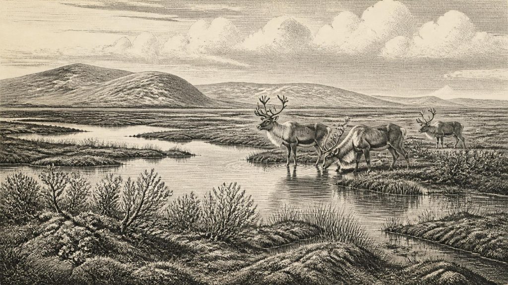
30,370 BCE, a modern chronological label, falls within the unstable Late Pleistocene rather than a recoverable Irish historical moment. At Derryvree, County Fermanagh, organic sediments between glacial tills record an ice-free freshwater wetland before the Last Glacial Maximum. Plant and insect remains indicate treeless, mossy tundra with pools, sedges, dwarf willow and mountain-avens, sustained by short summers and severe winters. Cave fauna from Castlepook suggests occasional cold-stage mammals, including mammoth and reindeer, but assemblages and dates require caution. No secure evidence establishes human settlement; a possibly cut-marked reindeer bone indicates only a tentative brief visit. Later ice obscured much evidence.
Dateline
30,370 BCE is a modern label imposed on a world that had no calendars, writing, named polities or historical memory. It cannot identify an event in Ireland, a ruler, a journey or even a single human generation. In archaeological terms, it falls in the Late Pleistocene, during Marine Isotope Stage 3, a climatically unstable part of the last Ice Age. The responsible way to approach this notional year is therefore through dated ranges, sediment layers, animal bones and fossil plants—not through a fabricated episode of Irish history.
In conventional calculation, 30,370 BCE is about 32,319 calendar years before AD 1950, the reference point used for “BP” dating. That is not the same thing as a radiocarbon age. Radiocarbon measurements must be calibrated against changing atmospheric carbon levels, and at this antiquity their calendar ranges are necessarily broad. The closest especially useful Irish evidence comes from Derryvree, near Maguiresbridge in County Fermanagh, where organic freshwater sediments have been dated to 30,500 radiocarbon years BP, with a substantial uncertainty. A published calibrated range of roughly 36,900–31,700 calendar years BP overlaps the horizon represented by this modern year-number, but cannot pinpoint it.
A Wetland Between Ice Advances
Derryvree was exposed by roadworks in 1969, when a cutting passed through a drumlin: the streamlined hill of glacial sediment now characteristic of much of the Irish midlands and north. Investigators found two distinct layers of till—material left directly by ice—with silts, fine sands and organic-rich deposits trapped between them. The sequence matters because it demonstrates change. Ice had affected the locality; then, for a time, open water and wet ground allowed sediment, plant remains and insects to accumulate; later glacial action buried and preserved the deposit beneath another till sheet.
That does not mean that every part of Ireland was ice-free at precisely the same moment, or that Derryvree supplies a map of the island. It does establish an ice-free freshwater environment in this portion of Fermanagh before the fullest expansion of the last British–Irish Ice Sheet. It is an exceptional survival. Later glaciers eroded, mixed or concealed much older ground surface across Ireland, so a thin wetland bed sealed within a drumlin is disproportionately valuable. The evidence records a locality and an interval, not a whole country frozen into one instant.
Treeless Ground and Short Summers
The Derryvree fossils indicate an open tundra or muskeg-like landscape: wet, mossy ground, pools and sedge-rich margins under a periglacial climate. Pollen was poorly preserved, but the plant macrofossils and insect evidence are more informative than a vague picture of “snow everywhere”. Mosses, herbaceous plants and aquatic or waterside species show that the growing season, though brief and demanding, supported living communities. Water-milfoil points to freshwater, while plants associated with cold open ground, including dwarf willow and mountain-avens, help define the wider setting.
This was not woodland. A few pollen grains of trees such as pine or hazel do not demonstrate a local forest: they may have travelled far, been redeposited or survived poorly. The better-supported interpretation is of sparse, treeless vegetation, with exposed mineral ground, wet hollows and a severe seasonal regime. Winters were long and cold; summers were sufficient for plants and insects to reproduce, and for standing water to persist. Such landscapes can appear barren at a distance, yet their pools, moss mats and sheltered margins can be ecologically varied.
The broader climatic context was one of volatility rather than a simple descent into ever greater cold. Around this period, northern Atlantic climates shifted repeatedly between relatively milder interstadial conditions and harsher stadial phases. Ireland lay at the western edge of the European landmass and was highly exposed to changes in ice, ocean and atmosphere. The Derryvree deposit belongs to the deteriorating conditions before the Last Glacial Maximum, not to the maximum itself. The major ice-sheet expansion came later, broadly after 31,000 years ago and reaching its greatest extent during the following several millennia.
Animals at the Atlantic Edge
Fermanagh’s wetland record is complemented, cautiously, by Irish cave fauna. Castlepook Cave—also known as Mammoth Cave—near Doneraile in north County Cork has yielded bones attributed to woolly mammoth, reindeer, giant deer, brown bear, wolf, Arctic fox, mountain hare, lemmings and spotted hyaena. Collectively, such remains show that Ireland could support, or at least intermittently receive, a cold-stage mammal community before the glacial maximum. Mammoths needed productive plant food; reindeer ranged across open country; hyaenas and wolves belonged to a predator and scavenger guild rather than an empty frozen wilderness.
Yet cave assemblages need careful handling. Bones may have been carried in by carnivores, moved by water, accumulated over many thousands of years or disturbed during early excavations. A species found in a Cork cave does not prove a permanent population across every Irish region, nor does it show that all the animals met one another. Recent reassessment has also shown that some older radiocarbon determinations on Irish fauna require renewed scrutiny. The strongest conclusion is modest but important: Late Pleistocene Ireland contained habitats capable of sustaining a richer and more dynamic fauna than its later, ice-scoured landscape might suggest.
The Human Question
There is no securely documented settlement, camp, hearth, dwelling, grave or tool assemblage that can be assigned to Ireland in 30,370 BCE. No political affairs, diplomacy, organised conflict, religion or learning can responsibly be reconstructed for the island at this date. There were no known Irish states, tribes or communities from which later history could be projected backwards. Silence in the record is not proof that no person ever entered Ireland, but it is a decisive limit on what can be claimed.
Castlepook has made that limit especially visible. A reindeer femur has been reported as bearing a mark consistent with cutting by a stone tool, and the claim has been presented as possible evidence of human carcass processing around 33,000 years ago. If the mark is confirmed as a fresh-bone tool cut, it would be evidence for a brief human presence or visit vastly earlier than Ireland’s well-established post-glacial settlement record. It would not demonstrate an enduring population, a village, a hunting territory or even the killing of the animal: people could have encountered an already-dead carcass and removed meat, hide or sinew.
The caution is heightened because Castlepook’s principal deposits were excavated in the early twentieth century, before modern standards of recording, sampling and stratigraphic control. The bone’s age and the interpretation of a mark on its surface are separate questions. A radiocarbon date concerns when the animal died; taphonomic analysis must decide whether a groove came from a tool, tooth, trampling or another process. Until direct dating, microscopic study and site context converge more securely, this remains a significant hypothesis rather than a foundation for a detailed human history.
No Society Yet Visible
Accordingly, Ireland’s economy at this horizon can only be discussed as animal and environmental ecology, not as a known human economy. There is no evidence for farming, herding, metalworking, pottery, permanent architecture, monuments or exchange networks based on the island. If people did reach this western margin of Europe, they would have moved through a low-sea-level world in which routes and coastlines differed profoundly from those of today. Movement need not have required a sea crossing of modern width, but the evidence does not allow a particular route, technology or relationship with neighbouring groups to be specified.
Nor can religion or culture be described beyond the possibility of human presence. The remarkable natural archive itself is the cultural lesson of this date: scientific knowledge is built from fragile traces. Plant fragments identify habitats; insect remains refine climate; bones reveal animal ranges; tills register the movement of ice; radiocarbon supplies probabilities rather than anniversaries. Together they replace the tempting but false image of a featureless Ice Age.
Before the Great Advance
The most important development around this horizon was environmental instability. In Fermanagh, a cold freshwater wetland occupied ground later sealed beneath advancing ice. Elsewhere, fauna associated with open cold-country environments ranged intermittently through parts of Ireland. The island was not yet the wholly ice-dominated landscape of the Last Glacial Maximum, but the conditions that would transform it were gathering force. Later ice would reshape drainage, scour bedrock, deposit tills and erase much of the evidence of the world represented at Derryvree.
For 30,370 BCE, then, Ireland’s history is not one of named people or singular events. It is the history of a treeless wetland beside shallow pools, of tundra plants surviving a hard seasonal climate, of large mammals moving through an exposed Atlantic landscape, and of an uncertain human trace in a Cork cave. Those are limited conclusions, but they are substantial ones: they show an Ireland alive, changing and still only partly recoverable beneath the legacy of the ice.
Primary Sources
- A Middle Midlandian Freshwater Series at Derryvree, Maguiresbridge, County Fermanagh, Northern Ireland
- Middle Midlandian Freshwater Series at Derryvree, Maguiresbridge, County Fermanagh, Northern Ireland
- Trimlines, Blockfields and the Vertical Extent of the Last Ice Sheet in Southern Ireland
- Growth and Retreat of the Last British–Irish Ice Sheet, 31,000 to 15,000 Years Ago: The BRITICE-CHRONO Reconstruction
- The Irish Quaternary Fauna Project
- A Reconsideration of the Radiocarbon Dating of the Marine Isotope Stage 3 Fauna from Southern Ireland
- Irish Pleistocene Biostratigraphy
- New Insights on the Fauna of Ireland's Younger Dryas and Early Holocene from Alice & Gwendoline Cave
- The Colonization of Ireland: A Human Ecology Perspective
- Palaeoecology
- Figure 6.— The Subdivision of the Quaternary Period in Ireland
- Ice Age Ireland: Cool Fossils! Did Woolly Mammoths Walk in Wicklow?
- Guide to the National Museum of Ireland – Natural History
- Exhibition Galleries
- Archaeological Heritage of County Cork
- Ireland's Palaeolithic Archaeology – Fleeting Footprints in a Frozen Land
- Introduction to the Late Quaternary and Holocene of Northern Ireland
- Cenozoic: Tertiary and Quaternary (Until 11,700 Years Before Present)
- The IntCal20 Northern Hemisphere Radiocarbon Age Calibration Curve (0–55 cal kBP)
- Proceedings: Postglacial Colonisation Conference





