
Castlepook Femur Modification30288 BCE
About 30,288 BCE, Ireland lay in the climatically unstable later Marine Isotope Stage 3, before the Last Glacial Maximum. Evidence is sparse and cannot identify communities or year-specific events. At Derryvree, County Fermanagh, freshwater sediments between glacial tills preserve mosses, sedges, aquatic plants and cold-tolerant shrubs, demonstrating a treeless but productive wetland during an ice-free interval. Castlepook Cave, County Cork, yielded reindeer, mammoth, giant deer, hyaena and other fauna, indicating ecological links with north-west Europe. A cut-marked reindeer femur may record Upper Palaeolithic carcass processing, but cannot prove settlement. Subsequent glaciation buried or destroyed much evidence of these dynamic landscapes.
Dateline
Modern calendar-year precision is not available for Ireland in 30,288 BCE. The label is a convenient point on a modern timescale, roughly 32,238 years before AD 1950, not a date at which an Irish event can be assigned to a particular season or generation. The responsible frame is the later part of Marine Isotope Stage 3, a climatically unstable interval before the global Last Glacial Maximum. Ireland was not yet the uniformly ice-covered landscape often imagined for the height of the Ice Age, but neither was it a settled country in any historical sense.
The strongest Irish evidence relevant to this broad period comes from deposits with wide chronological ranges, especially a buried freshwater bed at Derryvree near Maguiresbridge in County Fermanagh and animal remains from Castlepook Cave near Doneraile in north County Cork. Together they show that parts of Ireland could sustain cold-stage vegetation and large mammals during intervals before the final major expansion of the Irish Ice Sheet. They do not permit a narrative of named communities, rulers, wars, religions or diplomatic contacts in this particular numbered year.
A Date Within Deep Time
Radiocarbon dating does not translate straightforwardly into BCE years at this age. The Derryvree organic deposits produced the well-known Birmingham determination Birm-166 of 30,500 radiocarbon years before present, with a substantial uncertainty: 30,500+1,170−1,030 BP. “Before present” conventionally means before 1950, while radiocarbon years must be calibrated against changing atmospheric carbon levels to estimate calendar years. Calibration moves this determination thousands of years further back and leaves a broad probability range. It is therefore evidence for an environmental phase in the wider mid-to-late 30,000s calibrated years ago, not proof that a particular pond or plant community existed in precisely 30,288 BCE.
The same caution applies across the island. Ice, meltwater, erosion and later soil formation have removed or rearranged much of the older landscape. A surviving deposit records a place and a span of deposition; it is not a complete map of Ireland. The archaeological record is thinner still. There are no securely dated houses, hearths, tool-making floors, graves, monuments or art attributable to this moment. The absence of such evidence is not proof that no person ever arrived, but it prevents historians from describing a resident population with confidence.
A Wetland Beneath the Drumlin
Derryvree is exceptional because road cutting in 1969 exposed freshwater silts and fine sands sandwiched between two distinct sheets of till, the unsorted debris laid down by glacier ice. The sequence establishes a clear local order: ice had occupied the ground; open water and wet ground then developed; later glacial activity buried and preserved the sediments. It is a powerful reminder that the last Irish glaciation was not one uninterrupted blanket of ice. Landscapes could alter sharply as ice margins advanced, retreated or ceased to dominate a locality.
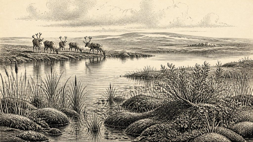
Plant and animal remains within the Derryvree sediments indicate a treeless, periglacial environment. Mosses, sedges, grasses and hardy flowering plants formed low vegetation around freshwater. Recorded plant remains include bogbean or buckbean (Menyanthes trifoliata), a wetland species, alongside plants associated with cold open ground such as dwarf willow, juniper and mountain-avens. Aquatic taxa, including water-milfoil, point to standing or slow-moving fresh water. This was not forested Ireland, nor a featureless polar desert: it was a patchwork of wet hollows, shallow water, sedge-rich margins and exposed ground under a severe climate.
Such evidence can support only local reconstruction. Derryvree does not demonstrate that every coast, valley and upland was identical. Yet its position in Fermanagh, beneath a drumlin subsequently shaped by ice, makes it particularly valuable. It confirms that a biologically productive freshwater setting existed in part of the island during a cold-stage interval before later glaciation sealed it away.
Large Animals in Southern Ireland
At Castlepook Cave, also known as Mammoth Cave, old excavations recovered an important but complicated accumulation of Late Pleistocene bones. The wider Irish Quaternary Fauna Project, and later redating, show that a varied mammal fauna reached Ireland between at least about 45,000 and 20,000 years ago. Castlepook’s assemblage includes animals suited to cold, open or mixed environments, among them reindeer, woolly mammoth, giant deer, brown bear, fox, hare and spotted hyaena. It demonstrates that Ireland was connected ecologically to the wider north-west European world, although the exact routes and timing of individual animal movements remain uncertain.
Caves require careful interpretation. Bone assemblages may result from carnivores dragging in prey, animals dying naturally, water moving remains, and excavation methods that did not meet modern stratigraphic standards. They cannot simply be read as a census of creatures standing together around the cave mouth. Nor can a faunal list establish a single climate or season. Nonetheless, reindeer and mammoth are meaningful indicators of the large-herbivore communities capable of using Irish landscapes during favourable cold-stage windows; hyaenas and other carnivores show that those communities also sustained predators and scavengers.
One Castlepook reindeer femur has attracted exceptional attention because a deep linear mark has been interpreted by zooarchaeologist Ruth Carden as a stone-tool cut made while a fresh carcass was processed. County Cork heritage material places the bone broadly around 31,000 BC, and a later programme of Castlepook research treats modified bones from older collections as a serious reason to seek intact deposits. If the identification is upheld, it could be evidence that people handled a reindeer in Ireland during the Upper Palaeolithic.
That conclusion must remain deliberately narrow. The bone’s age is not a date for the instant of marking, and the old cave collection has no securely associated lithic assemblage, hearth, shelter floor, human remains or repeated series of butchered carcasses. The mark is not evidence for a permanent settlement, a named hunting people, or an unbroken ancestry leading to later inhabitants. Around 30,288 BCE it is better understood as a tantalising possibility of episodic human presence within a landscape otherwise known principally through environmental and faunal evidence.
People, Movement and Livelihood
If people did reach Ireland in this phase, they would have belonged to highly mobile Upper Palaeolithic hunter-gatherer populations whose wider European world is documented far more richly than Ireland’s. Their food, technologies and social organisation cannot safely be imported wholesale into the Irish record. A reindeer-processing mark, if genuinely human, supports an action: cutting a carcass with a sharp stone edge. It does not reveal whether the animal was hunted, scavenged, processed at another place and later carried to the cave by carnivores, or divided among a travelling party.
There is likewise no responsible basis for political affairs, formal conflict, diplomacy, trade networks, ritual institutions or learned traditions in Ireland at this date. There were no states, kingdoms, written records, towns or farming communities evidenced here. It is possible that short-range exchange and social ties linked any visitors with groups in Britain or continental Europe, but this is an inference from geography and the mobility of Palaeolithic populations, not an Irish find. Lower sea levels exposed broad areas now beneath the sea, changing coastlines and making journeys different from those of today; they did not automatically create a simple, permanent land bridge into Ireland.
An Island Approaching Greater Cold
The large climatic story matters most. The global Last Glacial Maximum is usually placed around 26,500–19,000 years ago, later than this article’s notional date. Research on the British–Irish Ice Sheet shows that Ireland experienced changing ice configurations and that extensive ice would eventually transform the island’s terrain, depositing tills, carving basins and helping create the physical framework of many later landscapes. At Derryvree, the two tills enclosing the freshwater layer make that sequence visible in miniature: a living wetland lay between episodes of ice domination.
For people and animals, regional change would have been immediate rather than abstract. A shift in temperature, moisture, snow cover or ice margin could change pasture, access to water, predator pressure and possible travel routes within a few generations. The vegetation preserved at Derryvree offered seasonal forage and sheltered wetland niches, while the wider open country could support grazing herds. But instability was the defining condition. Any brief human incursion was vulnerable to the same environmental changes that later erased or buried much of the evidence.
What Can Be Said
Ireland around 30,288 BCE should therefore be approached as a landscape, not a nation in waiting. In the broad chronological neighbourhood of this artificial year, the evidence supports cold, treeless freshwater habitats in Fermanagh, a substantial Ice Age fauna in southern Ireland, and a possible but still limited sign of human carcass processing at Castlepook. It supports no Irish polity, no known community, no identifiable religious practice and no year-specific event.
The buried bogbean bed at Derryvree and the bones from Castlepook are important precisely because they are modest, material witnesses. They reveal that before the final major ice advance, Ireland contained ecological opportunities as well as cold and risk. Their message is not that prehistory can be made exact, but that deep-time Ireland was dynamic: water gathered beneath a future drumlin, tundra plants rooted at its edge, and great mammals moved through landscapes whose traces survive only in silt, bone and ice-laid sediment.
Primary Sources
- Middle Midlandian Freshwater Series at Derryvree, Maguiresbridge, County Fermanagh, Northern Ireland
- The Irish Quaternary Fauna Project
- A Reconsideration of the Radiocarbon Dating of the Marine Isotope Stage 3 Fauna from Southern Ireland
- New Insights on the Fauna of Ireland's Younger Dryas and Early Holocene from Alice & Gwendoline Cave
- The Colonization of Ireland: A Human Ecology Perspective
- Archaeology Research Excavation Grant 2022: Final Report
- Heritage Artefacts of County Cork
- The Quaternary of Ireland: Field Guide
- Deglaciation Chronology of the Donegal Ice Centre, North-West Ireland
- Trimlines, Blockfields and the Vertical Extent of the Last Ice Sheet in Southern Ireland
- Last Glacial Maximum Cirque Glaciation in Ireland and Implications for Reconstructions of the Irish Ice Sheet
- Radiocarbon Constraints on the Age of the Maximum Advance of the British–Irish Ice Sheet in the Celtic Sea
- Exploring the Collapse of the Last British–Irish Ice Sheet: A Comparison of Marine and Terrestrial Evidence
- Maximum Extent and Dynamic Behaviour of the Last British-Irish Ice Sheet West of Ireland
- The Last Glacial Maximum
- IntCal20 Northern Hemisphere Radiocarbon Age Calibration Curve (0–55 cal kBP)
- The Late Glacial Maximum in Great Britain and Ireland
- Subglacial Bedform Geomorphology of the Irish Ice Sheet Reveals Major Configuration Changes During Growth and Decay
- The Geology of Ireland: Cenozoic, Tertiary and Quaternary
- Soils of County Waterford
