
Derryvree’s Muskeg Interlude31727 BCE
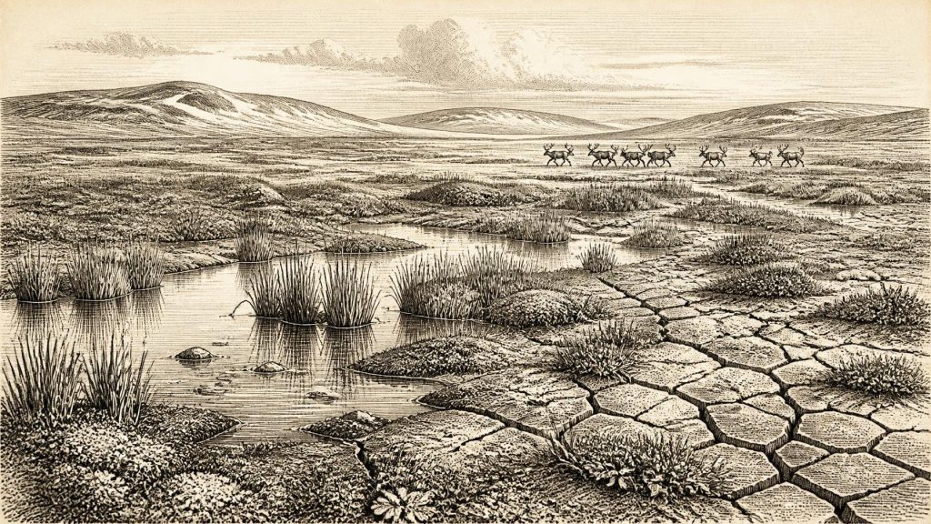
Labelled 31,727 BCE, this interval cannot be reconstructed as a single Irish year, but falls within late Marine Isotope Stage 3. At Derryvree, County Fermanagh, freshwater silts between glacial tills record an ice-free, periglacial tundra landscape of wetlands, sedges, mosses and sparse vegetation, later overridden by ice. Castlepook Cave, County Cork, preserves cold-adapted fauna including reindeer, mammoth, giant deer, bears and hyaenas, though its deposits span long periods. A cut-marked reindeer femur may indicate early human activity, but remains unconfirmed. Lower sea levels altered coasts, while renewed glaciation increasingly reshaped Ireland’s unstable, ecologically active landscape during this climatically variable period.
Dateline
31,727 BCE is a modern calendar label, not a recoverable Irish historical year. No written record, settlement sequence or deposit can be assigned to that single year. In archaeological terms it indicates a point roughly 33,700 calendar years before 1950, during the Late Pleistocene and broadly within Marine Isotope Stage 3 (MIS 3). The evidence is necessarily regional and ranged: radiocarbon determinations, fossil bones, pollen and insect remains, cave sediments, and traces of ice movement. These can illuminate the kind of Ireland that existed around this time, but not provide an annual chronicle.
The period lay before the Last Glacial Maximum, when the British–Irish Ice Sheet achieved its greatest late-ice-age extent. It was nevertheless a severe and unstable world. MIS 3 was not one uniform “Ice Age climate”, but a long span of alternating cold phases and relatively milder interstadials. Ireland stood at Europe’s north-western edge, exposed to Atlantic weather, shifting ice margins and changing sea levels. Later glaciers eroded or buried much of the older terrain, leaving a fragmentary archive rather than a continuous landscape history.
Dating a Lost Landscape
The apparent precision of 31,727 BCE must not be mistaken for scientific precision. Radiocarbon laboratories measure the residual carbon-14 in a sample and report an age in radiocarbon years before present, where “present” is conventionally 1950. Such measurements have margins of error and must be calibrated because atmospheric carbon-14 has varied markedly through time. At an age of more than thirty millennia, calibration commonly produces broad and sometimes irregular probability ranges rather than a neat calendar date.
The best relevant northern Irish sequence is at Derryvree, near Maguiresbridge in County Fermanagh. Road cutting through a drumlin in 1969 exposed freshwater silts and fine sands trapped between two thick sheets of till, the unsorted debris deposited by glacier ice. The order of those layers is decisive evidence: ice had occupied the locality; an ice-free interval followed in which water, sediment and organic remains accumulated; later ice advanced and sealed the deposit beneath another till.
Organic material from the Derryvree silts produced the important determination Birm-166, approximately 30,500 radiocarbon years BP, with a substantial uncertainty. Published discussion and modern calibration place its relevant calendar-age range broadly in the later MIS 3 interval, approximately 36,900–31,700 calibrated years BP, depending on the calibration model and confidence range used. The nominal year in this article falls within that broad window. It cannot, however, identify a particular season, generation or event at Derryvree.
Freshwater Between the Tills
Derryvree provides an unusually direct environmental picture. Its fossil plants and animals indicated open tundra vegetation and a periglacial regime: ground affected by frost and cold seasonal conditions, but not covered by an active glacier at the moment the freshwater sediments formed. The older terminology of a “muskeg” landscape usefully conveys wet, peaty or marshy ground, although it should not be imagined as an exact replica of any modern northern bog.
Low vegetation, sedges, mosses and hardy herbaceous plants could occupy wet hollows, pool margins and shallow channels. Dwarf shrubs may have found shelter where soils, slope and snow cover allowed. There is no evidence for a dense forest comparable with later Holocene Ireland. The ecological mosaic was likely open, exposed and highly seasonal, combining wetland pockets with bare mineral ground, grass- and herb-rich patches, frost-shattered slopes and local drainage lines.
This was not necessarily the same landscape across the whole island. Derryvree records one Fermanagh locality, not a national average. Yet its position between tills demonstrates a major regional change: northern ground that had supported freshwater life during this interval was subsequently overridden or buried as the last Irish ice sheet expanded. The landforms familiar in modern Ireland—drumlins, tills, erratic boulders and altered drainage systems—are in part the long-term legacy of those later glacial advances.
Castlepook’s Animal World
For the animal life of Ireland near this broad horizon, Castlepook Cave near Doneraile in north County Cork is indispensable. Excavations and collections from the cave have produced more than two thousand bones. They include remains attributed to woolly mammoth, reindeer, giant deer, brown bear and spotted hyaena; other late-ice-age finds include wolf, Arctic fox and lemmings. Improved radiocarbon pretreatment has shown that parts of the southern Irish cave fauna are older than earlier dating suggested, reaching well back into MIS 3.
The assemblage should not be read as a single day’s census, or even as one perfectly simultaneous community. Caves are selective archives. Carnivores carry prey and carrion into them; hyaenas can accumulate bones in dens; water and gravity can move deposits; and early twentieth-century excavation took place before modern stratigraphic practice. Individual bones from Castlepook span a long period. Nevertheless, the collection establishes that Ireland supported, or was repeatedly visited by, cold-adapted large mammals and predators before the maximum ice expansion.
Reindeer are especially informative. Their presence supports an interpretation of open country capable of sustaining grazing herds, rather than closed woodland. Mammoth and giant deer reinforce the impression of a richer Pleistocene fauna than historic Ireland possessed. Predators and scavengers were also part of this food web. Spotted hyaenas in particular help explain the cave’s bone concentrations, while wolves and bears point to a varied carnivore guild. Fossils show occurrence, not population size: they cannot establish how common any species was in a particular county or year.
The Uncertain Human Trace
A reindeer femur from Castlepook has made this period especially significant for Irish archaeology. It has been reported as about 33,000 years old and bears a deep linear mark interpreted by zoologist Ruth Carden as damage made by a sharp stone implement during the processing of fresh bone. If that interpretation is confirmed through continuing study, it would indicate a remarkably early episode of human activity in Ireland, far before the island’s better-established terminal-Pleistocene and Mesolithic evidence.
The proper conclusion remains cautious. The femur derives from an old cave collection, rather than a newly excavated camp floor with an intact sequence of associated tools, hearths and habitation debris. A radiocarbon result dates the animal bone itself; it does not automatically date the making of every mark upon it, nor establish a human settlement. Carnivore damage, sediment movement, weathering and the history of recovery all matter in taphonomic assessment. No securely associated stone-tool assemblage, dwelling, burial or repeatedly occupied site of this age has yet transformed Castlepook into proof of a permanent population.
Thus, human presence around 31,727 BCE is possible and potentially momentous, but not settled fact. The reindeer femur is best treated as a question of early visitation or animal processing, not evidence for an Irish people, tribe or enduring colony. It is precisely the kind of fragile clue that warrants further microscopic study, redating and controlled excavation.
Life Without a Political Record
There is no basis for describing governments, leaders, territories, diplomacy, warfare, religious institutions, formal learning or named communities at this date. Nor is there evidence for farming, permanent villages, craft specialisation or regular trade within Ireland. If people did reach the island, they would have belonged to Upper Palaeolithic hunter-gatherer worlds known elsewhere in north-west Europe, dependent upon mobility, detailed environmental knowledge and flexible use of animal and plant resources. That is an inference from wider European archaeology, not a directly demonstrated social portrait of Ireland.
The practical challenges would have been considerable. Cold, wind, variable snow cover and sparse winter food placed a premium on sheltered ground, fuel, clothing, routes and timely movement. The reindeer femur, if humanly modified, could imply the value of meat, marrow, hide or sinew; it cannot reveal the size of a group, its language, beliefs or duration of stay. The absence of evidence for homes or tools may partly reflect later glacial erosion and the limited survival of open-air sites, but absence cannot be converted into proof that people were present.
Changing Shores and Approaching Ice
Sea level was lower than today because vast quantities of water were held in northern ice sheets. Ireland’s coastline and the surrounding shelf were therefore markedly different, with more land exposed in some coastal areas. This did not necessarily create a simple, permanent walking route to Britain or continental Europe. Deep basins, tidal channels, sea ice, glaciers and changing shorelines made connectivity variable. Animal or human arrival depended on the geography and weather of particular intervals, not upon an assumed land bridge.
The larger development was the approach of renewed glaciation. Derryvree’s upper till shows that its freshwater tundra environment did not last indefinitely. During the following millennia the last Irish ice sheet thickened and expanded, ultimately remodelling much of the island. Around 31,727 BCE, therefore, Ireland was neither an empty white ice cap nor a familiar green island. It was a changing, partly ice-free northern landscape in which wetlands and open tundra could coexist with an increasingly powerful glacial system.
Its history survives in silts beneath a Fermanagh drumlin and bones in a Cork cave. Those records do not yield a year-by-year narrative, but they do preserve something more valuable than speculation: evidence that late-Pleistocene Ireland was ecologically active, climatically unsettled and still open to profound questions about animals, people and the coming ice.
Primary Sources
- A Middle Midlandian Freshwater Series at Derryvree, Maguiresbridge, County Fermanagh, Northern Ireland
- A Reconsideration of the Radiocarbon Dating of the Marine Isotope Stage 3 Fauna from Southern Ireland
- Phylogeographic, Ancient DNA, Fossil and Morphometric Analyses Reveal Ancient and Modern Introductions of a Large Mammal: the Complex Case of Red Deer (Cervus elaphus) in Ireland
- Castlepook Cave, County Cork: County Geological Site Report
- The Quaternary of Northern Ireland: Irish Quaternary Association Field Guide
- The Subdivision of the Quaternary Period in Ireland
- Dimensions and Chronology of the Last Ice Sheet in Western Ireland
- Growth and Retreat of the Last British–Irish Ice Sheet, 31,000 to 15,000 Years Ago: the BRITICE-CHRONO Reconstruction
- Pattern, Style and Timing of British–Irish Ice Sheet Advance and Retreat Over the Last 45,000 Years: Evidence from NW Scotland and the Adjacent Continental Shelf
- Early Deglaciation of the British-Irish Ice Sheet on the Atlantic Shelf Northwest of Ireland Driven by Glacioisostatic Depression and High Relative Sea Level
- Character of Advance and Retreat of the Southwest Sector of the British-Irish Ice Sheet During the Last Glaciation
- New Data for the Last Glacial Maximum in Great Britain and Ireland
- The IntCal20 Northern Hemisphere Radiocarbon Age Calibration Curve (0–55 cal kBP)
- Ireland: Submerged Prehistoric Sites and Landscapes
- First Evidence of a Late Upper Palaeolithic Human Presence in Ireland
- New Insights on the Fauna of Ireland’s Younger Dryas and Early Holocene from Alice & Gwendoline Cave
- Castlepook Cave, Co. Cork, 2022
- Heritage Artefacts of County Cork
- Mammoth Cave (Castlepook Cave)
- Irish Quaternary Association Field Guides
- Outreach and Education Resources
