
Maguirebridge’s Fossil Clock31609 BCE
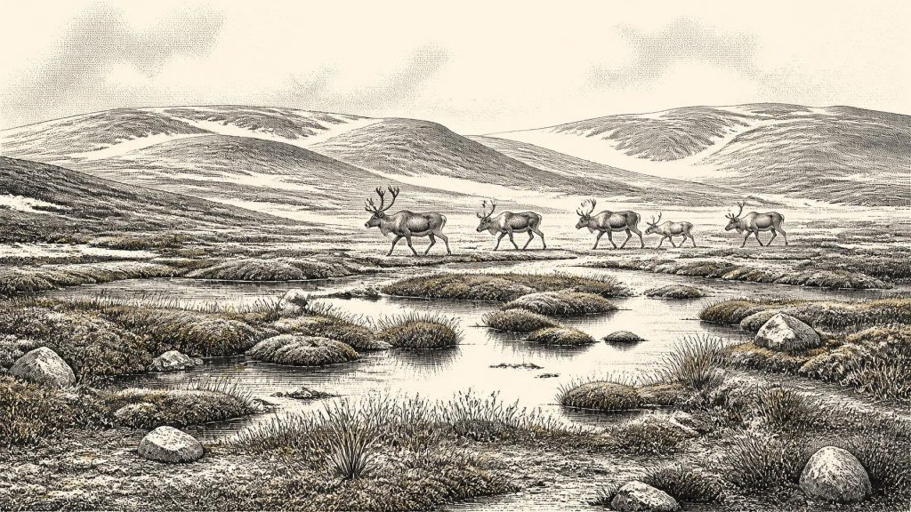
31,609 BCE is a modern label, not a precisely recoverable Irish event. During Marine Isotope Stage 3, Ireland was approaching greater glaciation but was not uniformly ice-covered. At Derryvree, County Fermanagh, organic sediments between tills, radiocarbon dated broadly around this period, preserve evidence of treeless, waterlogged tundra with grasses, sedges, mosses and shallow pools. Castlepook Cave, County Cork, yielded cold-climate fauna including mammoth, reindeer and spotted hyaena, although disturbed cave deposits require caution. A cut-marked reindeer bone may indicate Upper Palaeolithic butchery, not settlement. Sparse, eroded evidence portrays an ecologically connected yet difficult-to-reach Ice Age island with uncertain access routes.
Dateline
31,609 BCE is not a year that can be recovered from Ireland’s archaeological record. It is a modern calendar label, roughly 33,558 years before the conventional radiocarbon baseline of AD 1950, not a date that any contemporary person could have known or recorded. At this depth of time, even very good evidence normally dates an organism or deposit to a range, often with sizeable uncertainty. Ireland offers no settlement surface, human skeleton, hearth or tool assemblage that can responsibly be assigned to this single year. What it does preserve are scattered, scientifically important clues to the wider Late Pleistocene world in which that notional date falls.
The evidence places Ireland within Marine Isotope Stage 3, a long, climatically unstable portion of the last Ice Age. The island was approaching, but had not yet reached, the maximum development of the last British–Irish Ice Sheet. Reconstructions differ over the size and distribution of early ice, because direct evidence before about 31,000 years ago is sparse. Yet the best current synthesis indicates that the major expansion towards the later glacial maximum followed the period around 35,000–32,000 years ago, while ice-sheet volume peaked much later, around 23,000 years ago. The Ireland of 31,609 BCE should therefore not be imagined as uniformly buried beneath the immense ice sheet of the Last Glacial Maximum. It was instead a changing northern landscape of ice margins, exposed ground, wet hollows, caves and shifting animal habitats.
A Date With Limits
The distinction between calendar years and radiocarbon years matters especially here. The key Fermanagh evidence, from Derryvree near Maguiresbridge, produced a radiocarbon result of 30,500 years before present, with an uncertainty of +1,170 and −1,030 years (Birm-166). “Before present” means before AD 1950, and the measurement is not itself a calendar age. Atmospheric radiocarbon has varied over time, so such results need calibration against curves such as IntCal20. At ages beyond 30,000 years, calibration produces broad probability ranges rather than a neat conversion. Derryvree can illuminate the broad environmental interval around the requested date; it cannot certify what happened in 31,609 BCE itself.
The same warning applies to the famous finds from Castlepook Cave, also called Mammoth Cave, near Doneraile in north County Cork. The cave fauna includes remains attributed to woolly mammoth, reindeer, brown bear, wolf, Arctic fox, lemmings and spotted hyaena. Individual bones have different histories, and an age obtained from one specimen does not date the whole cave assemblage. Many remains were excavated in the early twentieth century, before modern standards of stratigraphic recording, and cave deposits are particularly vulnerable to disturbance by carnivores, water, collapse and earlier digging. Their value is real, but it demands caution.
Waterlogged Tundra at Derryvree
Derryvree is the clearest Irish environmental archive for this general phase. Roadworks in 1969 cut through a drumlin and exposed freshwater silts and fine sands trapped between two thick till sheets. That geological arrangement is crucial: the organic layer records an interval when the locality was ice-free, while the tills above and below show that glacial ice had occupied the area at other times. Later ice did not erase every earlier landscape; it sealed a small, difficult-to-read survival beneath the drumlin.
Plant pollen, seeds, mosses and insects from the deposit point to open tundra or muskeg rather than forest. Grasses, sedges, juniper and herbaceous plants occurred in a largely treeless terrain. Fossils of bogbean, dwarf willow and mountain avens are among the plants used to reconstruct the local setting. The insects and plant remains suggest wet, peaty ground with shallow open water and plant-rich margins, surrounded by mossy vegetation. This was not necessarily an unbroken plain. It was a periglacial mosaic: saturated hollows, pools, exposed mineral soils and low vegetation, shaped by cold winters, short growing seasons and frost action.
That reconstruction is evidence-based, but its scale must be kept in view. Derryvree documents one preserved basin in County Fermanagh, not every valley or coast of Ireland. Nor do all the identified species prove that they grew together in the same season or year. Pollen can travel, remains may be reworked, and the dated layer accumulated over time. Nevertheless, the combined botanical and insect evidence firmly rejects a familiar modern image of a green, wooded island. Around this part of the Ice Age, northern Ireland had places where trees were absent and wet tundra plants could flourish beside cold water.
Animals and a Cave in Cork
Castlepook gives southern Ireland a different kind of record: bones rather than a continuous environmental sediment. The fauna indicates that large herbivores and predators reached Ireland during milder or more accessible phases of the last glacial cycle. Woolly mammoth and reindeer evoke the open, cold-adapted communities often called mammoth-steppe, but the term should not flatten local variety. A cave assemblage is not a census of a living landscape. Hyaenas, wolves and other scavengers could transport, gnaw and accumulate bones, while geological processes could mix material of different ages.
Spotted hyaena is especially revealing. Its presence at Castlepook is securely important as evidence of a carnivore now confined to Africa and absent from later Irish ecosystems. A hyaena den or scavenging site also explains why caves can preserve such an unusual concentration of bones: they were places where animals brought food, sheltered or died, not necessarily places where humans lived. The National Museum of Ireland describes Castlepook as the country’s most important site for mammal remains from the last cold stage. It is a record of animal movement and ecological opportunity at the north-western edge of Europe.
The cave also raises the possibility of a much earlier human visit to Ireland than was once accepted. A reindeer femur in the National Museum collection has been identified by zoologist Ruth Carden as bearing a mark consistent with cutting by a sharp stone tool during butchery. County Cork heritage material places the bone at about 31,000 BCE, close enough to the requested date to make it the most evocative object for this article. If that interpretation is upheld, people processed a reindeer in Ireland during the Upper Palaeolithic and perhaps used the animal’s meat, hide, marrow, sinew or bone.
But the inference must remain proportionate to the find. No associated stone tool, hearth, dwelling, human bone or securely excavated occupation level has yet been recovered from Castlepook for this early episode. The bone’s radiocarbon age dates the animal, not an exact moment of cutting; the cave may have received discarded remains after butchery elsewhere; and identifying a surface mark requires specialist taphonomic judgement. The responsible conclusion is not that a settled Irish population existed in 31,609 BCE. It is that one modified reindeer bone offers a serious, still limited indication that Upper Palaeolithic hunters may have reached the island during this broader period.
People Beyond the Evidence
Nothing in the Irish evidence permits the naming of a people, language or political territory. There were no states, kingships, diplomatic missions or written agreements to recover, and there is no direct evidence for warfare in Ireland at this date. Nor can religion be reconstructed from the Castlepook mark or the Derryvree wetland. Elsewhere in Upper Palaeolithic Europe, hunter-gatherers made sophisticated tools, ornaments, images and seasonal camps, but those wider achievements cannot simply be transferred to Ireland without Irish finds to support them.
Any human presence was likely small, mobile and intermittent. That is an interpretation from geography and ecology, not a demonstrated population history. Reaching Ireland required crossing or negotiating the Irish Sea zone, whose changing sea levels, ice and coastlines made routes variable and uncertain. Low global sea level exposed more continental shelf than today, but this did not automatically create an easy, continuous land route from Britain into Ireland. The old assumption of a straightforward Late Glacial land bridge has been strongly challenged by marine geological research. People, if present, may have travelled by water, over seasonal ice or through a geography unlike any modern map; present evidence cannot decide which.
Approaching a Colder Ireland
The principal historical development around 31,609 BCE was environmental rather than political: Ireland was entering the trajectory towards more extensive glaciation. Ice growth would alter drainage, destroy or bury habitats and repeatedly narrow the zones available to plants, animals and possible human visitors. The later maximum ice sheet scoured vast areas, helping to explain why the surviving record is so thin. Absence of evidence is therefore not simple evidence of absence. It is partly the result of erosion, submerged former landscapes and the survival of only exceptional archives such as a cave bone collection or an organic layer beneath a drumlin.
For Ireland Year by Year, then, this date marks neither a documented event nor a human milestone with calendar precision. It marks a window onto a precarious Ice Age island: Derryvree’s waterlogged tundra, Castlepook’s cold-climate fauna and a contested but important reindeer bone. Together they show that Ireland was ecologically connected to the wider north-west European world, while remaining difficult to enter, harder to inhabit and exceptionally difficult for later archaeologists to read.
Primary Sources
- A Middle Midlandian Freshwater Series at Derryvree, Maguiresbridge, County Fermanagh, Northern Ireland
- The Irish Quaternary Fauna Project
- Exploring the extent and chronology of the last British-Irish Ice Sheet in the North Channel, Irish Sea Basin and Celtic Sea
- Growth and Retreat of the Last British–Irish Ice Sheet, 31,000 to 15,000 Years Ago: The BRITICE-CHRONO Reconstruction
- Extent and Timing of the Last Glacial Maximum (LGM) in Britain and Ireland: A Review
- Dimensions and Chronology of the Last Ice Sheet in Western Ireland
- Trimlines, Blockfields and the Vertical Extent of the Last Ice Sheet in Southern Ireland
- Response of the Irish Ice Sheet to Abrupt Climate Change During the Last Deglaciation
- Radiocarbon Constraints on the Age of the Maximum Advance of the British-Irish Ice Sheet in the Celtic Sea
- The Timing and Magnitude of the British–Irish Ice Sheet Between Marine Isotope Stages 5d and 2
- Pattern and Timing of Retreat of the Last British-Irish Ice Sheet
- Spotted Hyena Skull
- Heritage Artefacts of County Cork
- 2022:564 – Castlepook Cave, Castlepook South, Cork
- Occurrence of Mammalia Relicts at Site Castlepook Cave
- New Insights on the Fauna of Ireland's Younger Dryas and Early Holocene from Alice & Gwendoline Cave
- Figure 6: The Subdivision of the Quaternary Period in Ireland
- Palaeoecology
- Menyanthes trifoliata
- Salix herbacea
- Dryas octopetala
- The IntCal20 Northern Hemisphere Radiocarbon Age Calibration Curve (0–55 cal kBP)
- IntCal Publications
- The Problem of a Late Quaternary Landbridge Between Britain and Ireland
- Radiocarbon Dates from the Oxford AMS System: Archaeometry Datelist 31
- Groningen Radiocarbon Dates VIII
