
Fermanagh–Cork Window31239 BCE
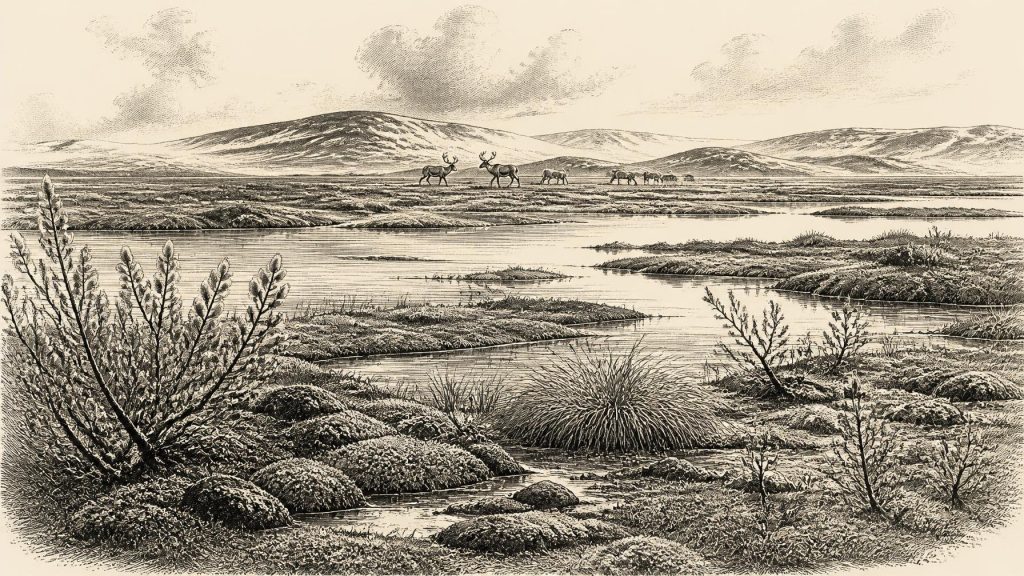
The modern date 31,239 BCE is an imprecise label for later Marine Isotope Stage 3, not a recorded Irish year. Derryvree, County Fermanagh, preserves organic silts between glacial tills, indicating an ice-free interval with treeless, tundra-like freshwater wetlands. Castlepook Cave, County Cork, contains reworked remains of reindeer, mammoth, giant deer and predators, demonstrating cold open habitats but not a single contemporary fauna. A modified reindeer bone may indicate brief human presence, although no settlement evidence exists. Later ice expansion extensively reshaped Ireland, explaining the scarcity of early traces. This period reveals changing environments more clearly than human history in Ireland.
Dateline
The label 31,239 BCE is a modern chronological convenience, not a year for which Ireland possesses an event, ruler, settlement or dated human life. In conventional archaeological arithmetic it falls about 33,188 years before AD 1950, but such a conversion must not be mistaken for calendar-year precision. Radiocarbon measurements have uncertainties; their calibration produces ranges rather than single dates; and deposits accumulated over periods that may have lasted generations or millennia. The responsible setting is therefore later Marine Isotope Stage 3 (MIS 3), a fluctuating part of the Late Pleistocene, well before the fullest expansion of the last British–Irish Ice Sheet.
What can be said concerns environments, animal life and a very small, contested body of evidence for people. Ireland was not a historical country in any political sense. There were no states, chiefs known by name, diplomatic relations, written beliefs or recoverable traditions. Nor is there evidence for a permanent population. Yet the island was not simply an unchanging blank beneath ice. Sediments in County Fermanagh and cave faunas in County Cork preserve glimpses of cold, open landscapes that supported plants and animals during intervals before the later glacial maximum.
A Date Outside Annual History
The numbered year lies broadly within the time-span illuminated by the Derryvree organic deposits at Maguiresbridge, County Fermanagh. There, freshwater organic silts occur between two layers of glacial till. This sequence establishes a relative history: glacier ice had deposited the lower till; an ice-free interval then allowed wetland sediment, plant remains and small animal evidence to accumulate; later ice advanced over the locality and laid down the upper till. It is strong evidence for local environmental change, not a weather report for every part of Ireland.
An older radiocarbon measurement from Derryvree was 30,500 ± 1,200 radiocarbon years BP. Scholarship has expressed its calibrated implications broadly, including a range of roughly 36,900–31,700 calibrated years BP. The modern label 31,239 BCE happens to fall within that broad chronological neighbourhood, but no scientifically defensible method can attach the deposit to that exact year, season or generation. The traditional name “Derryvree Cold Phase” is useful shorthand, though it should not imply a single uniform climate or an island-wide event.
Wetland in a Treeless Land
Derryvree’s fossils make the landscape more tangible. The organic silts have yielded evidence for a treeless, cold wetland or muskeg, with sedges, mosses and plants suited to open ground and shallow freshwater. Bogbean (Menyanthes trifoliata), dwarf willow, mountain-avens and other cold-tolerant taxa have been used to reconstruct a damp tundra-like mosaic rather than a forested Ireland. Pools, marshy ground, stream margins and patches of herb-rich vegetation could coexist with drier, frost-affected surfaces.
This was a severe setting, but not necessarily a featureless snowfield. Seasonal thaw, standing water and short growing seasons offered ecological niches. Inferences about exact temperatures, annual snowfall or the extent of permafrost must remain cautious because the evidence comes from one preserved basin and because Ireland’s ice margins were mobile. Still, the biological assemblage decisively demonstrates that this Fermanagh locality was capable of sustaining freshwater life between glacial episodes. The future drumlin landscape was not yet a finished landscape; it was part of a terrain repeatedly remodelled by ice, meltwater, frost and sediment.
Castlepook’s Animal Archive
Nearly 300 kilometres to the south-west, Castlepook Cave near Doneraile in north County Cork preserves a different kind of archive. Its passages and chambers, formed in limestone, produced a remarkable collection during excavations conducted between 1904 and 1913. Among the recorded remains are reindeer, woolly mammoth, giant deer, brown bear, wolf, Arctic fox, mountain hare, lemmings and spotted hyaena. These species do not prove that every animal lived together at one moment. Cave deposits accumulated over long intervals, and bones were moved by carnivores, water, sediment disturbance and, in places, earlier excavation.
That warning is fundamental. Castlepook is not a neatly sealed camp or a snapshot of one hunting expedition. The Irish Quaternary Fauna Project found that its bones represented widely differing ages and that some deposits had been heavily re-sorted. More recent redating using improved bone pretreatment has shown that several older determinations underestimated the age of Castlepook specimens by thousands of radiocarbon years. The cave nevertheless establishes that southern Ireland was reached by a distinctive cold-stage fauna during MIS 3. The combination of grazing animals, carnivores and small Arctic-adapted mammals is consistent with extensive open country, though it cannot furnish an exact map of vegetation or animal abundance in 31,239 BCE.
For everyday animal life, the cave also supplies a corrective to romantic images of a peaceful “mammoth-steppe”. Reindeer and giant deer were potential prey, but a landscape containing hyaenas, wolves and bears was dangerous. Hyaenas may have used caves as dens or scavenging places; bears also used sheltered cavities. Some bones may represent animals that fell into fissures or died naturally, rather than kills made by people. The evidence reveals an ecosystem and its hazards, not a settled human food economy.
The Human Question
Castlepook matters especially because a reindeer bone from the older collection has been reported as bearing a deep modification interpreted as a cut or chopping mark made on fresh bone with a sharp stone implement. Public discussion has associated this find with an age of about 33,000 years ago. If the mark was made by a person at or soon after the animal’s death, it would be evidence for a human incursion into Ireland in the Middle Upper Palaeolithic, far earlier than the substantial Mesolithic record.
But this is a conclusion to weigh, not a foundation upon which to invent a community. The bone derives from an old collection rather than a modern excavation of an intact activity floor. No securely associated stone-tool assemblage, hearth, shelter, human burial, art, repeatedly occupied surface or manufacturing debris of comparable age has yet been recovered at Castlepook. The 2022 investigation located surviving deposits and recovered animal remains, but reported no cultural artefacts; some charcoal and hazelnut material proved modern when dated. The appropriate interpretation is therefore possible brief human activity, perhaps carcass processing by a small travelling party, rather than proof of permanent settlement or continuous occupation.
This distinction also protects the significance of the find. A single modified bone may be slight evidence, but in an island whose later glaciation destroyed, buried or reworked many potential sites, it is worth serious attention. Caves and museum collections can preserve evidence that open-air sites have lost. Yet the absence of excavated habitation evidence means that it cannot answer such questions as where these people slept, how many travelled together, which language they spoke, or whether they returned.
No Politics, No Proven Trade
There is no basis for describing political affairs, warfare, diplomacy, institutions or territorial boundaries in Ireland at this horizon. Nor can trade be demonstrated. An Upper Palaeolithic group capable of reaching Ireland, if one did, would have possessed social knowledge, practical skill and access to stone tools; but no Irish assemblage of this date identifies the raw materials, transport routes or exchange relationships involved. Lower sea levels changed the outline of the continental shelf, but changing sea level, ice cover and the geography of crossings make any particular route into Ireland uncertain. It is safer to say only that movement into or across the region was environmentally possible at some times and difficult at others.
Religion, formal learning and visual culture are likewise beyond recovery. No shrine, grave, ornament, image, musical object or intentional ritual deposit can be securely assigned to Ireland around this date. The people potentially represented by the Castlepook bone may have had complex beliefs and skills comparable to other Upper Palaeolithic populations in Europe, but that is a general comparison, not Irish evidence. Responsible history must preserve the difference.
The Approaching Ice Age Peak
The long-term importance of this period lies in its position before a dramatic environmental contraction. Research on the British–Irish Ice Sheet indicates that the later Last Glacial Maximum covered all or almost all Irish low ground, with major expansion towards the Atlantic shelf edge after about 24,720 calibrated BP. At 31,239 BCE, that maximum lay ahead. Ireland’s ice history was not a simple on–off sequence: local glaciers, ice sheets, open lowlands and periglacial environments could vary between regions and through time. But later ice advance would scour landscapes, redistribute sediment and make the survival of early archaeological traces exceptionally unlikely.
Thus the best picture for this date is deliberately modest but not empty. In Fermanagh, a cold freshwater wetland lay between episodes of glaciation. In southern Ireland, cave deposits record large herbivores and predators adapted to open Ice Age terrain. A marked reindeer bone raises the possibility that people briefly entered this world, but does not document a settlement. Ireland around 31,239 BCE was neither a kingdom nor an unpeopled abstraction: it was a changing northern landscape whose sparse archives preserve ecology more clearly than human story.
Primary Sources
- A Middle Midlandian Freshwater Series at Derryvree, Maguiresbridge, County Fermanagh, Northern Ireland
- Quaternary Deposits and Glacial Stratigraphy in Ireland
- Figure 6.— The Subdivision of the Quaternary Period in Ireland
- The Irish Quaternary Fauna Project
- A Reconsideration of the Radiocarbon Dating of the Marine Isotope Stage 3 Fauna from Southern Ireland
- Archaeology Research Excavation Grant 2022: Castlepook Cave Project Final Report
- 2022:564 – Castlepook Cave, Castlepook South, Cork
- First Evidence of a Late Upper Palaeolithic Human Presence in Ireland
- New Insights on the Fauna of Ireland's Younger Dryas and Early Holocene from Alice & Gwendoline Cave
- Maximum Extent and Dynamic Behaviour of the Last British–Irish Ice Sheet West of Ireland
- Growth and Retreat of the Last British-Irish Ice Sheet, 31,000 to 15,000 Years Ago: The BRITICE-CHRONO Reconstruction
- Extent and Deglacial Chronology of the Last British–Irish Ice Sheet: Implications of Exposure Dating Using Cosmogenic Isotopes
- Trimlines, Blockfields and the Vertical Extent of the Last Ice Sheet in Southern Ireland
- Dimensions and Chronology of the Last Ice Sheet in Western Ireland
- Late Pleistocene Chronostratigraphy and Ice Sheet Limits, Southern Ireland
- Quaternary
- Ireland: Submerged Prehistoric Sites and Landscapes
- The Problem of a Late Quaternary Landbridge Between Britain and Ireland
- Deglaciation, Earth Crustal Behaviour and Sea-Level Changes in the Determination of Insularity: A Perspective from Ireland
- The IntCal20 Northern Hemisphere Radiocarbon Age Calibration Curve (0–55 cal kBP)