

The Maguiresbridge Waterline31059 BCE
31,059 BCE is a modern label rather than a date resolvable in Irish archaeology. Derryvree, near Maguiresbridge, preserves freshwater silts and organic remains between two tills, indicating a locally ice-free interval within unstable Marine Isotope Stage 3. Radiocarbon dating places the deposit broadly around 34,950–29,750 BCE, not in a specific year. Plant and insect evidence depicts treeless, frost-worked tundra wetland with pools, sedges and cold-adapted vegetation. Castlepook Cave records Ice Age fauna, though not simultaneous occupation. Later ice expansion reshaped Ireland. No reliable evidence identifies humans, settlements or societies; these fragmentary archives instead reveal changing climates, waters and animal communities.
Dateline
“31,059 BCE” is a modern calendar label, not a date that can be identified in Ireland’s archaeological record. It is roughly 33,008 years before AD 1950, the conventional reference point for “BP” dating, but no excavated Irish deposit can resolve conditions to that particular year. The responsible subject is therefore a broad Late Pleistocene horizon: part of Marine Isotope Stage 3 (MIS 3), a climatically unstable interval before the Last Glacial Maximum. The strongest evidence comes from sediments and fossils that span centuries or millennia, not from an event, ruler, settlement or calendar day.
A Date Inside a Range
The nearest important Irish chronological marker is the Derryvree freshwater series near Maguiresbridge, County Fermanagh. Organic material from this deposit produced the conventional radiocarbon determination BIRM-166: 30,500 radiocarbon years BP, with a large uncertainty of +1,170/−1,030 years. Radiocarbon years are not identical to calendar years because the amount of atmospheric carbon-14 has varied through time. Modern calibration therefore turns this result into a broad probability range rather than a single answer. The interval is commonly placed at approximately 36,900–31,700 calibrated years BP, or about 34,950–29,750 BCE. The article’s notional year falls within that broad span, but it cannot be assigned to a particular layer, season or episode at Derryvree.
This distinction matters. It would be misleading to say that a particular animal crossed Fermanagh, that a pool froze, or that an ice margin advanced in 31,059 BCE. What can responsibly be said is that the Derryvree evidence illuminates an interval in which part of northern Ireland was locally ice-free long enough for freshwater sediment and organic remains to accumulate. It also shows that this interval lay between two episodes of glacial deposition. The landscape had already been affected by ice, and it would later be overridden or surrounded by renewed ice-sheet growth.
Freshwater Beneath a Drumlin
Derryvree is valuable because roadworks in 1969 exposed an unusual sequence through a drumlin. Beneath the familiar streamlined hill were two distinct layers of till: unsorted sediment deposited by glacier ice. Between them lay freshwater silts and fine sands containing plant and animal remains. This was not an ancient village site and it produced no architecture, tools or burials. Its importance lies in the order of the deposits. A former glacial phase created the lower till; an interval without ice at that spot permitted a wetland or shallow-water environment to develop; then a later glacier sealed the evidence beneath another till.
The deposits do not provide a map of the whole island. A local freshwater basin may have persisted while high ground, nearby valleys or other regions experienced very different conditions. Nor do the sediments show that Ireland was continuously free of ice. They do, however, firmly contradict any simple image of an island uniformly buried beneath a permanent ice sheet throughout the whole last cold stage. Around the broad period represented by BIRM-166, Ireland contained changing local environments whose histories must be reconstructed separately.
An Open, Frost-Worked Country
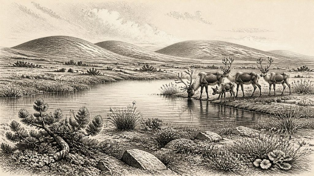
Plant macrofossils, pollen, mosses and insect evidence from Derryvree support an open, treeless, frost-influenced landscape. Grasses, sedges, herbs and juniper occur among the principal indicators, while aquatic and wet-ground plants show that freshwater persisted in the basin. A seed of bogbean (Menyanthes trifoliata) is especially telling: it is evidence for wet margins or shallow freshwater, not for a featureless desert of snow and stone. Other records associated with the deposit include cold-adapted plants such as mountain-avens and lesser clubmoss. Together they support comparison with tundra and muskeg-like wetland, provided those modern labels are treated as approximations rather than exact replicas of a living Irish ecosystem.
The likely scene was therefore one of pronounced seasonality. Short summers could support low vegetation around pools, sedge-rich ground and damp hollows; winter cold, wind and repeated freezing would have constrained tree growth and disturbed exposed soils. The evidence is stronger for a mosaic of wet ground and sparse open vegetation than for continuous pasture or woodland. It gives no secure annual temperature for 31,059 BCE, and Ireland’s Atlantic position makes simple comparisons with continental tundra hazardous. Yet the biological remains show that freshwater life and cold-tolerant vegetation could endure in at least one northern basin during this long, variable cold-stage interval.
Caves and Mobile Fauna
Southern Ireland supplies a different kind of evidence. Castlepook Cave, also known as Mammoth Cave, near Doneraile in County Cork, has yielded one of the island’s most important Ice Age mammal assemblages. Its remains include spotted hyena, reindeer, mammoth, giant deer, brown bear, wolf, Arctic fox, lemmings and mountain hare. The cave record demonstrates that, before the later maximum expansion of the British–Irish Ice Sheet, Ireland was at times part of a wider north-west European zone in which cold-stage mammals could reach and occupy suitable habitats.
These animals must not be turned into a parade for a single year. Cave deposits are commonly accumulated over long periods, and many Irish assemblages were excavated in the nineteenth and early twentieth centuries, when recording methods were less exacting than today. Later accelerator radiocarbon work has revised some apparently young dates from southern Irish caves, showing that certain faunal remains are substantially older than once thought. Castlepook is thus excellent evidence for the wider MIS 3 faunal world, but it cannot prove that every listed species stood together in Cork in 31,059 BCE.
Before the Greatest Ice Expansion
The period represented by Derryvree preceded the global Last Glacial Maximum, generally dated to about 26,500–19,000 years ago. In Ireland, the most extensive later ice-sheet configuration developed after the interval discussed here, with evidence indicating maximum offshore and marine-margin positions broadly around 25,000–23,000 years ago in several sectors. The later Irish Ice Sheet reached far onto the Atlantic shelf in the west and was linked to the larger British–Irish Ice Sheet system. Its advance reshaped lowlands, deposited tills, deepened basins and destroyed or buried much older surface evidence.
At about 31,059 BCE, then, regional change rather than stasis is the key theme. Ice, water, exposed ground and ecological corridors shifted over long timescales. Lower sea levels altered coastlines and exposed parts of the continental shelf, but the available evidence does not justify drawing a single reliable shoreline or land bridge for this precise year. Nor can animal bones by themselves demonstrate a particular migration route. They show possibility and presence across broad intervals; they do not provide a timetable of arrivals.
No Irish Society Yet Documented
There is no reliable evidence for a human community in Ireland at this date. No securely dated camp, hearth, stone-tool assemblage, grave, dwelling or artwork belongs to around 31,059 BCE. The National Museum of Ireland accordingly notes that clear evidence for Palaeolithic human presence has not emerged. Research at Alice and Gwendoline Cave in County Clare has produced evidence relevant to human activity much later, in the terminal Pleistocene, while sustained settlement is associated with Mesolithic communities after the Ice Age. Such discoveries make the question of very early visitation worth investigating; they do not establish people in Ireland during the Derryvree interval.
Political affairs, warfare, diplomacy, religion, learning, trade and social hierarchy therefore cannot be reconstructed for Ireland in this period. There were no documented polities, leaders, exchange networks or ritual institutions. Predators competed with prey and carcasses were scavenged, but that is ecology, not human conflict. Likewise, the movement of reindeer or hyena across a changing northern landscape must not be described as trade. The only responsible “economy” here is the natural circulation of energy through plants, herbivores, carnivores, freshwater organisms and seasonal habitats.
What This Horizon Means
The Maguiresbridge evidence gives Ireland a deep history richer than a simple blank before farming and monuments. Around the broad range containing 31,059 BCE, the island was not a historical society waiting to begin; it was a changing cold-stage environment. At Derryvree, freshwater accumulated between glacial episodes and preserved traces of tundra wetland. At Castlepook, bones preserve evidence of a lost animal world. These archives are fragmentary, locally specific and sometimes difficult to date, but they are tangible. Their lesson is not that one dramatic thing happened in a named year. It is that Ireland’s landscape, waters and animal communities were already being repeatedly remade by climate and ice tens of millennia before the first securely documented human societies on the island.
Primary Sources
- A Middle Midlandian Freshwater Series at Derryvree, Maguiresbridge, County Fermanagh, Northern Ireland
- The IntCal20 Northern Hemisphere Radiocarbon Age Calibration Curve (0–55 cal kBP)
- The IntCal20 Approach to Radiocarbon Calibration Curve Construction: A New Methodology Using Bayesian Splines and Errors-in-Variables
- IntCal
- Landscapes and Environments of the Last Glacial-Interglacial Transition: A Time of Amazingly Rapid Change in Ireland
- Menyanthes trifoliata
- The Irish Quaternary Fauna Project
- A Reconsideration of the Radiocarbon Dating of the Marine Isotope Stage 3 Fauna from Southern Ireland
- Spotted Hyena Skull
- New Insights on the Fauna of Ireland's Younger Dryas and Early Holocene from Alice & Gwendoline Cave
- Prehistoric Details
- Mesolithic – Iron Age
- Quaternary Site Descriptions
- 2022:564 – CASTLEPOOK CAVE, Castlepook South, Cork
- Radiocarbon Constraints on the History of the Western Irish Ice Sheet Prior to the Last Glacial Maximum
- Extent and Deglacial Chronology of the Last British–Irish Ice Sheet: Implications of Exposure Dating Using Cosmogenic Isotopes
- Trimlines, Blockfields and the Vertical Extent of the Last Ice Sheet in Southern Ireland
- Dimensions and Chronology of the Last Ice Sheet in Western Ireland
- Late Pleistocene Chronostratigraphy and Ice Sheet Limits, Southern Ireland
- Oscillating Retreat of the Last British-Irish Ice Sheet on the Continental Shelf Offshore Galway Bay, Western Ireland
- Stratigraphic and Palaeo-Geomorphological Evidence for the Glacial-Deglacial History of the Last British-Irish Ice Sheet in the North-Western Irish Sea
- Timing and Pace of Ice-Sheet Withdrawal Across the Marine–Terrestrial Transition West of Ireland During the Last Glaciation
- Growth and Retreat of the Last British-Irish Ice Sheet, 31,000 to 15,000 Years Ago
- Geological Heritage Audit Report: County Cork