
Arenaria at Maguiresbridge30703 BCE
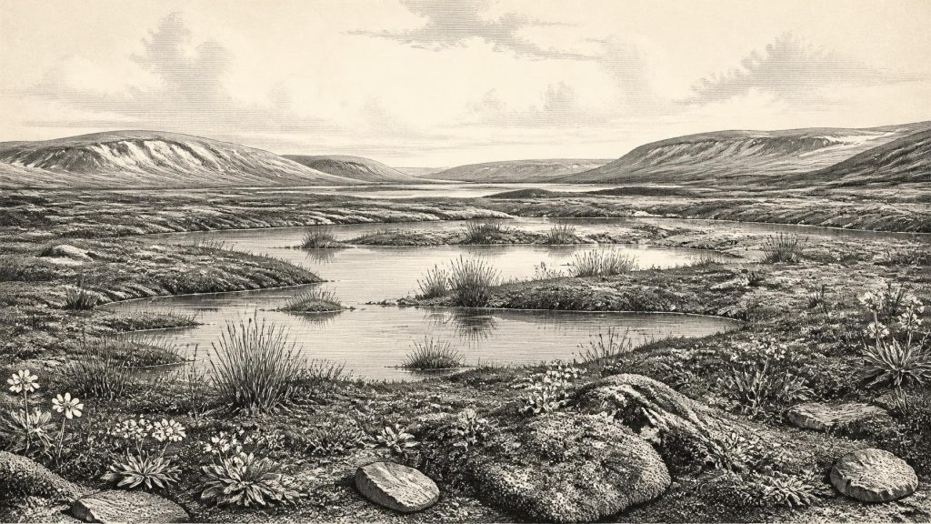
Around 30,703 BCE, Ireland’s history is reconstructed from Late Pleistocene environmental evidence rather than dated events or human activity. At Derryvree near Maguiresbridge, freshwater silts between glacial tills, radiocarbon dated broadly to 34,950–29,750 BCE, record a temporary ice-free, periglacial wetland. Pollen, plants, insects and mosses indicate treeless tundra, shallow water and ecological variety, including fringed sandwort. Castlepook Cave’s disturbed, long-lived bone deposits show intermittent connections to wider European fauna, including mammoth, reindeer and hyaena, but cannot describe one year. No secure human presence is known. The period reflects fluctuating ice, habitats, drainage and faunal opportunities before the Last Glacial Maximum.
Dateline
30,703 BCE is a modern calendar label, not a date that can be isolated in Ireland’s archaeological record. No writing, settlement sequence, annual calendar, named community or political event permits a history of this single year. In conventional archaeological terms, it lies roughly 32,650 calendar years before AD 1950, the reference point used for “before present” dating. It belongs to the Late Pleistocene, broadly Marine Isotope Stage 3 (MIS 3), a climatically unstable part of the last Ice Age. The responsible approach is therefore to use calibrated ranges, stratigraphy and fossil evidence, while keeping a sharp distinction between what those sources demonstrate and what they merely suggest.
The most useful Irish evidence close to this notional date is not a human artefact but a buried wetland at Derryvree, near Maguiresbridge in County Fermanagh. Its freshwater deposits illuminate a cold, locally ice-free interval within a changing glacial landscape. They do not describe the whole island, nor do they show what happened in one particular year. Alongside them, animal remains from Castlepook Cave in north Cork reveal that Ireland was connected, at intervals, to a wider north-west European fauna. Yet the cave deposits accumulated over many millennia and have suffered disturbance. They cannot be compressed into a single scene for 30,703 BCE.
A Date Inside a Range
Derryvree was exposed by roadworks in 1969, when a cutting passed through a drumlin about two kilometres north-east of Maguiresbridge. Investigators found fine sands and freshwater silts, including organic material, enclosed between two substantial till sheets. Till is sediment laid down directly by glacier ice. The sequence is consequently important in itself: ice had occupied the ground; then water, plants and sediments accumulated during an ice-free interval; finally, another advance buried that record beneath fresh glacial debris.
Organic material from the freshwater beds produced the radiocarbon determination BIRM-166, 30,500 radiocarbon years before present, with an uncertainty of +1,170 and −1,030 years. Such a result is not the same as a calendar date. Atmospheric radiocarbon has varied through time, and calibration converts the laboratory result into a probability range rather than a precise anniversary. Modern calibration has placed the Derryvree deposit broadly between about 36,900 and 31,700 calibrated years before present, approximately 34,950–29,750 BCE. The requested year falls within that wide span, but cannot be tied to a particular layer, season, animal or human action.
This limitation matters. The dated material accumulated within a wetland, rather than being a sealed time capsule deposited on one day. Furthermore, its date concerns one locality in south Fermanagh. It securely indicates that the Derryvree area was not continuously buried beneath ice throughout the wider period represented by the range. It does not prove that every region of Ireland was ice-free at the same time, or that the island experienced a single uniform climate. The word “around” is therefore indispensable.
A Wetland in Cold Country
Even with those cautions, Derryvree offers an unusually vivid environmental archive. The freshwater silts contained poorly preserved herb pollen, moss remains, plant macrofossils and insects. Together these support an open tundra or tundra-like landscape under periglacial conditions: ground affected by intense frost even where it was not permanently covered by glacier ice. The setting was not a woodland. Herbs, mossy ground, shallow water and sparsely vegetated drier surfaces formed a mosaic shaped by low temperatures, short growing seasons and seasonal freezing.
The record includes plants now associated with high-latitude or alpine habitats, among them fringed sandwort, Arenaria ciliata. Aquatic and wet-ground remains point to standing or slowly moving freshwater, while the insect evidence suggests pools rich in plant matter amid mosses. These observations permit a careful reconstruction of habitat: a cold wetland set within largely treeless country. They do not supply a temperature reading for 30,703 BCE, a complete list of plants across Ireland, or an image of uninterrupted bleakness. Periglacial environments could contain productive patches in summer, especially beside water, even as winters were severe.
Such local variety is a useful corrective to the old shorthand of an island simply “under ice”. Ireland’s Pleistocene history was one of advancing and retreating ice, changing drainage, exposed ground and short-lived ecological opportunities. Derryvree is valuable because the two tills physically bracket one such opportunity. The later glacier preserved the wetland evidence, but also signals that these conditions were temporary on geological timescales. Environmental change, rather than a political turning point or cultural development, was the dominant historical process.
Before the Last Maximum
The date falls before the best-defined maximum of the last British–Irish Ice Sheet, generally placed around 26,500–19,000 years before present. It would be mistaken, however, to imagine a quiet interval before an abrupt later freeze. Research on the ice sheet shows that its growth before the Last Glacial Maximum was complex, with advances and retreats varying between regions. Evidence from Ireland and the surrounding seas indicates glaciation before MIS 2, while Irish cave and sediment records preserve episodes of milder, wetter or more open conditions during MIS 3.
Derryvree therefore belongs to a longer story of regional instability. Its lower till records an earlier glacial presence; its organic freshwater deposits record a subsequent ice-free phase; its upper till records later ice expansion. The exact timing, thickness and extent of ice over particular Irish districts at 30,703 BCE remain uncertain. The evidence is much stronger for the sequence of changing conditions than for a map of the entire island in any one numbered year.
Coastlines, too, were unlike those of today. Global sea level was substantially lower during the Ice Age, exposing parts of the continental shelves and altering the geography of routes between Ireland, Britain and the European mainland. Yet lowered seas should not be turned into an automatic claim that people or animals could simply walk to Ireland at this exact time. Sea passages, ice margins, rivers, terrain and changing coastlines all mattered. The animal record demonstrates past faunal connections; it does not establish the precise route, season or frequency of every crossing.
Castlepook’s Long Faunal Record
At Castlepook Cave near Doneraile, County Cork, excavations recovered more than 2,000 bones from Ice-Age deposits. The assemblage includes woolly mammoth, giant deer, reindeer, brown bear and spotted hyaena; later material includes Arctic fox, wolf and lemmings. It is Ireland’s richest known cave record for vertebrate life leading towards the Last Glacial Maximum. These animals show that Ireland was not biologically isolated from the continent and that, at different times, habitats existed capable of supporting cold-stage grazers, browsers, predators and scavengers.
But Castlepook is not a reliable census of one landscape or year. The dated bones span a very long period, roughly 45,700 to 19,950 years before present. Water movement, earlier excavation practices and the behaviour of hyaenas complicate the deposits further. Re-dating has shown that some animals once thought relatively late are considerably older; giant deer and spotted hyaena may have disappeared locally before about 40,000 calibrated years ago. A mammoth, reindeer or hyaena bone from Castlepook is consequently evidence of Ice-Age Ireland, not proof that those species stood together near Maguiresbridge in 30,703 BCE.
The cave nevertheless changes the scale on which Derryvree can be understood. The Fermanagh wetland was part of an island repeatedly open enough for plants and animals to establish themselves, but exposed to profound climatic volatility. Predators and scavengers may have transported carcass parts into caves; animals may also have died naturally in fissures or dens. The deposit records biological presence and accumulation processes, not a human hunting camp.
People, Power and Silence
No secure Irish settlement, hearth, tool assemblage, dwelling, grave or monument is known from this period. The National Museum of Ireland accordingly notes that clear evidence for human presence in Ireland during the Palaeolithic has not emerged. The currently accepted direct evidence for people is far later: a butchered brown-bear patella from Alice and Gwendoline Cave in County Clare dates to about 12,810–12,590 calibrated years before present. It cannot be projected back some 20,000 years to make a human society at Derryvree.
Claims sometimes attached to individual modified animal bones require exceptional care, especially where nineteenth- and early twentieth-century excavations disturbed cave deposits. A cut or incised surface can be important, but without secure context it does not create an archaeological culture, a population estimate or a settled occupation. For 30,703 BCE, the evidence does not responsibly support named hunters, migration narratives, seasonal camps, or a human economy based on mammoth or reindeer.
Accordingly, there is no evidence for political authority, warfare, diplomacy, trade, religion, artistic tradition, formal learning or social institutions in Ireland at this point. Their absence from this account is not a judgement that people elsewhere lacked complex lives; it reflects the absence of demonstrable people in Ireland itself. Nor should animal behaviour be mistaken for human conflict or economy. The central actors recoverable from the Irish record are glacier ice, frost, water, plants, insects and animals.
What This Year Can Mean
The history of Ireland around 30,703 BCE is thus a history of evidence and scale. At Derryvree, sediments trapped between tills preserve a cold freshwater world in south Fermanagh, dated only within a broad calibrated range. At Castlepook, cave bones preserve a longer, more complicated record of Ice-Age fauna in Cork. Together they show an Ireland of environmental openings and closures, not an empty abstraction but neither a landscape for which a year-by-year human narrative can honestly be written.
The most important development was the unstable relationship between ice and ice-free ground. Wetlands could form, tundra vegetation could take hold, and animals could reach or persist in parts of the island; later glacial expansion could erase habitats and rework landscapes. That is the proper significance of this distant calendar year: not a dated event, but a point within a changing Late Pleistocene world whose surviving archives are scarce, local and exceptionally precious.
Primary Sources
- A Middle Midlandian Freshwater Series at Derryvree, Maguiresbridge, County Fermanagh, Northern Ireland
- Palaeoecology: Guide 16
- The Irish Quaternary Fauna Project
- A Reconsideration of the Radiocarbon Dating of the Marine Isotope Stage 3 Fauna from Southern Ireland
- Castlepook Cave: County Geological Site Report
- 2022:564 – Castlepook Cave, Castlepook South, Cork
- Prehistoric Details: Stone Age Collections
- First Evidence of a Late Upper Palaeolithic Human Presence in Ireland
- New Insights on the Fauna of Ireland's Younger Dryas and Early Holocene from Alice & Gwendoline Cave
- The IntCal20 Northern Hemisphere Radiocarbon Age Calibration Curve (0–55 kcal BP)
- The Timing and Magnitude of the British–Irish Ice Sheet Between Marine Isotope Stages 5d and 2
- Dimensions and Chronology of the Last Ice Sheet in Western Ireland
- Trimlines, Blockfields and the Vertical Extent of the Last Ice Sheet in Southern Ireland
- Timing and Pace of Ice-Sheet Withdrawal Across the Marine–Terrestrial Transition West of Ireland During the Last Glaciation
- The Deglaciation of the Western Sector of the Irish Ice Sheet from the Inner Continental Shelf to its Terrestrial Margin
- Oscillating Retreat of the Last British-Irish Ice Sheet on the Continental Shelf Offshore Galway Bay, Western Ireland
- Pattern and Timing of Retreat of the Last British–Irish Ice Sheet
- Growth and Retreat of the Last British–Irish Ice Sheet, 31,000 to 15,000 Years Ago: the BRITICE-CHRONO Reconstruction
- Episodic Speleothem Deposition Tracks the Terrestrial Impact of Millennial-Scale Last Glacial Climate Variability in SW Ireland
- The Last Glacial Maximum
