

Derryvree’s GI-5.2 Wetland30689 BCE
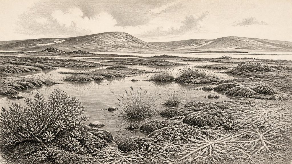
At 30,689 BCE, Ireland cannot be assigned a year-specific event or known human community. The Derryvree sequence in County Fermanagh records freshwater organic sediments between tills, showing a locally ice-free interval before later glaciation. Its broadly calibrated date encompasses this nominal year, but not precisely. Fossil plants and insects indicate treeless, cold wetland with mosses, sedges, shallow pools and Arctic-alpine vegetation. Other sites demonstrate changing regional conditions, while Castlepook Cave confirms Marine Isotope Stage 3 mammals, not a contemporaneous fauna or settlement. Possible human visits remain unproven. Environmental change, ice movement, wetlands and animal dispersal therefore provide the defensible history.
Dateline
The label 30,689 BCE gives a useful position on a modern timeline, but it cannot identify an event in Ireland in the manner of a later historical year. No local calendar, written record, settlement sequence or securely dated human action can be resolved to this single year. Expressed in the convention used by Quaternary scientists, it falls roughly 32,638 years before AD 1950, within the Late Pleistocene and Marine Isotope Stage 3, a notably unstable interval of the last Ice Age. The most responsible account is therefore one of dated ranges, deposits and probabilities rather than rulers, wars or anniversaries.
On the Greenland ice-core chronology, this nominal point falls during Greenland Interstadial 5.2, a comparatively milder episode beginning about 32,500 years before 2000. That does not mean Ireland experienced a uniform or directly measurable version of the Greenland climate in this exact year. It does, however, place the island within a North Atlantic world in which abrupt changes between colder stadials and milder interstadials repeatedly altered ice, vegetation, water and animal habitat. Ireland’s own evidence is much less precisely dated, but it shows that parts of the island were not continuously entombed beneath ice during this broader period.
A Wetland Between Ice Advances
The strongest Irish evidence relevant to this date comes from Derryvree near Maguiresbridge, County Fermanagh. A road cutting through a drumlin exposed a remarkable sequence: freshwater silts and fine sands, rich in organic material, lay between two thick deposits of till. Till is the unsorted mixture of clay, stones and boulders left by glacier ice. The stratigraphy demonstrates a sequence that is more important than any imagined annual episode: glacial ice had occupied the site; fresh water then ponded and sediments accumulated in an ice-free interval; later ice again covered or passed over the locality, burying the wetland archive.
Organic material from the Derryvree bed produced the conventional radiocarbon determination BIRM-166, 30,500 radiocarbon years before present, with a substantial uncertainty of +1,170 and −1,030 years. A radiocarbon age is not identical to a calendar age. Once calibrated, the result has been placed broadly between about 36,900 and 31,700 calibrated years before present, approximately 34,950–29,750 BCE. The notional year considered here lies within that wide span, but no individual layer can be assigned to 30,689 BCE. Derryvree is a record accumulated over a considerable period, not a snapshot or a diary.
The deposit is nevertheless a decisive corrective to a simple picture of an all-ice Ireland. It indicates that north-central Ireland was locally ice-free at some point before the principal expansion of the last Irish Ice Sheet. Recent chronological modelling uses Derryvree as evidence for ice-free conditions before later build-up, while also recognising the limitations of an old conventional radiocarbon determination. The finding is local, not island-wide: it cannot prove that every Irish region was free of ice, or that conditions remained unchanged through the full calibrated range.
Mosses, Pools and Open Ground
Derryvree’s fossil plants and insects give the best available impression of everyday environmental conditions. The evidence points to treeless, periglacial country rather than the wooded Ireland familiar from later prehistory. Grasses, sedges, herbs, dwarf shrubs and a rich moss flora occupied wet ground and drier patches around shallow water. Finds including bogbean, water-milfoil, dwarf willow, mountain avens and Arctic-alpine plants suggest a varied but cold freshwater margin. Insect remains likewise support the interpretation of a muskeg-like landscape: saturated, organic-rich ground with shallow pools, mossy edges and abundant plant debris.
This was not necessarily a featureless snowfield. During favourable seasons, low vegetation could exploit wet soils, exposed mineral ground and the margins of standing water. Yet the absence of forest is meaningful. A landscape without mature woodland offered little shelter, limited fuel in the form of timber and a sharply seasonal supply of edible plants. Winters were severe, frost and permafrost affected ground conditions, and the relationship between open water, snow cover and frozen soil could change markedly over short distances. The plants are direct evidence of local habitats; describing the wider landscape as tundra or muskeg is a careful environmental interpretation of that evidence.
Other Irish sites underline that such conditions varied regionally. At Aghnadarragh beside Lough Neagh, a longer sequence preserves tills, organic beds and stratified sediments recording several changing Late Pleistocene environments. In south-west Ireland, uranium-thorium dates from speleothems in Crag Cave show that liquid water could enter caves during a series of milder phases in the last glacial cycle. These sites do not supply a single synchronous Irish weather map, but together they reveal an island of shifting ice margins, wetlands, open ground and short-lived climatic opportunities.
The Mammal Corridor
Animal bones from Irish caves offer a second, more fragmented line of evidence. Castlepook Cave near Doneraile in north County Cork, long known as Mammoth Cave, has yielded remains of woolly mammoth, reindeer, giant deer, spotted hyaena, wolf, Arctic fox and small cold-adapted mammals. The Irish Quaternary Fauna Project and later redating work showed both the importance and the difficulty of this archive. Some earlier radiocarbon results required revision as pretreatment methods improved, and cave deposits had been affected by carnivores, water movement, natural deaths and antiquarian excavation.
The consequence is crucial. Castlepook documents that a changing assemblage of large mammals reached Ireland during Marine Isotope Stage 3, but it is not a census of animals alive together in 30,689 BCE. Nor can its cave bones alone establish the exact routes by which they arrived. Lower sea levels exposed broad continental shelves and altered the configuration of land, sea and ice around Ireland and Britain; access was likely more intermittent and environmentally complex than on the modern map. Reindeer and other cold-adapted fauna indicate ecological links with north-west Europe, but every species had its own requirements, movements and chronological history.
For the human story, Castlepook is both tantalising and inconclusive. A reindeer femur from the cave has been interpreted as bearing a deep mark made by a sharp stone tool during butchery, and has been publicised as dating to roughly 33,000 years ago. If that interpretation is confirmed, it would represent extraordinarily early evidence of people handling an animal in Ireland. It does not demonstrate a settlement. No securely associated hearth, lithic assemblage, dwelling surface, burial, food store or undisturbed butchery floor has been found there for this period. The bone’s age dates the animal, while the disturbed cave context makes the date and circumstances of the mark harder to establish.
No Polities, No Proven Communities
There is no evidence from Ireland at this depth of time for political institutions, diplomacy, warfare, territorial states or named communities. Equally, there is no basis for describing a regular Irish trade network, a religion with identifiable rites, or a tradition of formal learning. Such absences are not mere gaps in an otherwise rich record; they define the kind of history that can be written. The environmental archive tells us much more about water, vegetation, ice and animals than about social organisation.
It remains possible that small groups of Upper Palaeolithic hunter-gatherers entered Ireland episodically during favourable windows. Continental Europe and Britain had human populations with sophisticated hunting, stone-working and symbolic traditions during the wider period. But possibility is not evidence of residence. Around 30,689 BCE, Ireland has no secure material record from which to reconstruct families, camps, language, exchange or belief. The later, well-dated evidence for Upper Palaeolithic human activity at Alice and Gwendoline Cave in County Clare, around 12,800–12,600 calibrated years before present, should not be projected backwards by twenty millennia.
Even the word ‘Ireland’ needs care. It usefully identifies the territory of the modern island, but no Irish people, Irish language or Irish political identity existed. The landscape itself was in flux. The eventual Last Glacial Maximum, when the British–Irish Ice Sheet reached its greatest late-glacial extent, lay thousands of years ahead, broadly between 27,000 and 23,000 calibrated years ago in current reconstructions. Derryvree belongs to the earlier story of climatic oscillation and ice-sheet growth, not to the final maximum.
What This Year Can Mean
The most defensible picture for 30,689 BCE is therefore of a time represented indirectly by the Derryvree wetland: a cold, open and locally ice-free Fermanagh landscape of mosses, sedges and freshwater pools, within an unstable North Atlantic climate. Elsewhere, cave faunas show that Ireland was part of a broader ecological zone visited by large mammals, predators and scavengers. Later ice would reshape and conceal much of this terrain, while sea-level change would erase or submerge potential routes and sites.
That is not a lesser form of history. It is history on the timescale appropriate to the evidence: sediment settling in still water, plants growing at a pool edge, animals moving through a changing cold landscape, and ice returning to bury the record. At this date, environmental change is the principal historical development. The surviving evidence can illuminate an Irish Ice-Age world, but it cannot honestly furnish a year-specific human event.
Primary Sources
- A Stratigraphic Framework for Abrupt Climatic Changes During the Last Glacial Period Based on Three Synchronized Greenland Ice-Core Records: Refining and Extending the INTIMATE Event Stratigraphy
- The IntCal20 Northern Hemisphere Radiocarbon Age Calibration Curve (0–55 cal kBP)
- Exploring Controls of the Early and Stepped Deglaciation on the Western Margin of the British Irish Ice Sheet
- Figure 6: The Subdivision of the Quaternary Period in Ireland
- Landscapes and Environments of the Last Glacial-Interglacial Transition: A Time of Amazingly Rapid Change in Ireland
- Episodic Speleothem Deposition Tracks the Terrestrial Impact of Millennial-Scale Last Glacial Climate Variability in SW Ireland
- A Reconsideration of the Radiocarbon Dating of the Marine Isotope Stage 3 Fauna from Southern Ireland
- The Irish Quaternary Fauna Project
- Character of Advance and Retreat of the Southwest Sector of the British-Irish Ice Sheet During the Last Glaciation
- Response of the Irish Ice Sheet to Abrupt Climate Change During the Last Deglaciation
- Dimensions and Chronology of the Last Ice Sheet in Western Ireland
- BRITICE Glacial Map, Version 2: A Map and GIS Database of Glacial Landforms of the Last British-Irish Ice Sheet
- Timing and Pace of Ice-Sheet Withdrawal Across the Marine–Terrestrial Transition West of Ireland During the Last Glaciation
- First Evidence of a Late Upper Palaeolithic Human Presence in Ireland
- New Insights on the Fauna of Ireland’s Younger Dryas and Early Holocene from Alice & Gwendoline Cave
- Archaeology Research Excavation Grant 2022: Castlepook Cave, Co. Cork
- Heritage Artefacts of County Cork
- Quaternary Sediments 1:50,000 Map Service
- Aghnadarragh
- The Colonization of Ireland: A Human Ecology Perspective





