
Derryvree’s Wetland Interval30640 BCE
Around 30,640 BCE, Ireland’s history is reconstructed from uncertain environmental evidence rather than dated events. At Derryvree in County Fermanagh, freshwater silts between glacial tills record a cold, treeless, periglacial wetland with pools, sedges, mosses and hardy plants. The deposit, broadly dated to 36,900–31,700 calibrated years BP, shows local ice-free conditions before later extensive glaciation. Cave fauna indicates diverse Late Pleistocene mammals, although not necessarily contemporaneously. A possibly cut-marked reindeer bone suggests early human activity, but no secure settlement evidence exists. Ireland was environmentally dynamic, intermittently habitable, and later ice obscured much of its record. No political or trade networks.
Dateline
30,640 BCE is not a year that can be recovered from Ireland’s archaeological record. No community in Ireland named it, no event can be assigned to it, and no written chronology existed. The label is a modern calendar convenience. In radiocarbon terms it falls about 32,600 years before AD 1950, in the later part of Marine Isotope Stage 3 (MIS 3), a climatically volatile phase of the last Ice Age. The responsible history of Ireland at this point is therefore not a story of rulers or dated happenings, but of evidence with broad chronological margins: buried sediments, fossil plants, insects, animal bones, glacial landforms and the contested traces of possible human activity.
A Date With Wide Margins
The most illuminating Irish evidence near this notional date comes from Derryvree, near Maguiresbridge in County Fermanagh. Roadworks in 1969 cut through a drumlin and revealed an unusual sequence. Beneath one glacial till and above another lay freshwater silts and fine sands containing organic material. That order matters. It shows that ice had crossed the locality, that an interval of exposed ground and freshwater followed, and that ice later returned or expanded over the basin, sealing the deposit beneath more glacial debris.
The original radiocarbon determination from the organic horizon, Birm-166, was 30,500 radiocarbon years before present, with a substantial uncertainty of roughly a thousand years either way. A radiocarbon age is not a calendar age: atmospheric carbon-14 levels have varied through time, and older results must be calibrated against an evolving scientific curve. Published calibrations place the Derryvree interval broadly around 36,900–31,700 calibrated years BP, approximately 34,950–29,750 BCE. The modern date 30,640 BCE lies within that broad range, but it cannot identify a particular season, generation or individual deposit layer at Derryvree.
That distinction is essential. The silts do not prove that all Ireland was ice-free, nor do they provide a map of the whole island in a single moment. They preserve one local environmental archive from a landscape repeatedly altered by ice, meltwater, erosion and later sedimentation. Their importance lies precisely in their survival: a small freshwater world entombed within the glacial architecture of Fermanagh’s drumlin country.
Cold Ground and Open Water
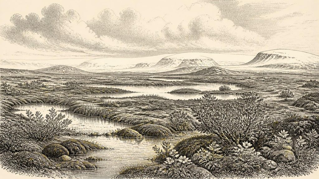
Derryvree’s plant and insect evidence points to a cold, open and almost certainly treeless landscape. Grasses, sedges, herbs, mosses and juniper occur alongside plants associated with Arctic-alpine or wet ground. Mountain-avens, dwarf willow and lesser clubmoss indicate exposed, cold-tolerant vegetation. Bogbean and water-milfoil are especially valuable clues because they signal wet margins or shallow freshwater. The older term muskeg has been used for this kind of setting: waterlogged, organic-rich ground with mossy edges and pools, rather than a continuous forest or an entirely dry grassland.
The result is not a picture of a uniformly snow-covered wasteland. The evidence supports a mosaic. There were shallow pools and silty water, sedge-rich edges, damp mossy hollows, patches of low herbaceous vegetation and more exposed mineral ground. Repeated freezing and thawing probably disturbed soils, while short summers could have brought quick growth around water. Winters, by contrast, were severe. Trees were absent or extremely scarce locally; there is no basis for imagining the familiar oak, hazel and elm woodland of much later prehistoric Ireland.
This was a periglacial environment: land affected by intense cold and seasonal frost, near or within the wider sphere of ice-sheet change, but not necessarily buried under glacier ice at the time the organic deposit accumulated. The two tills enclosing the freshwater series demonstrate change rather than permanence. Ireland’s landscape during MIS 3 was not static. Ice margins advanced and retreated on long timescales, while climate oscillated sharply on shorter ones. Derryvree preserves a cold interval in which liquid freshwater, plants and invertebrates could nevertheless persist.
Ireland Before the Last Glacial Maximum
The wider setting was the growth phase of the last British–Irish Ice Sheet. The fullest Last Glacial Maximum lay later, with major expansion across and beyond Ireland occurring chiefly after about 31,000 years ago and reaching maximum extent around 26,000 calibrated years BP in many sectors. At 30,640 BCE, therefore, Ireland stood on the threshold of more extensive glaciation, not at a simple, island-wide climatic peak. Modern reconstructions increasingly emphasise that ice growth and retreat were asynchronous: conditions differed between uplands, lowlands, coasts and offshore basins, and the chronology remains less secure before the main maximum.
Derryvree is particularly significant because it establishes an ice-free local basin in Ulster during this earlier part of the last glacial cycle. Yet it must not be made to carry more than it can bear. Later glaciers obscured or destroyed much of the older terrestrial record. The precise extent of Irish ice around 32,600 calibrated years BP is still debated, and large regional reconstructions necessarily combine landforms, marine cores, numerical modelling and dates of uneven quality. The sound conclusion is modest but important: parts of Ireland could support open freshwater and tundra-like environments before the later, more extensive ice advance.
Animals in a Changing Landscape
Irish cave deposits add another strand of evidence. Castlepook Cave, near Doneraile in County Cork, has produced remains attributed to a varied Late Pleistocene fauna, including woolly mammoth, reindeer, giant deer, red deer, brown bear, wolf, Arctic fox and spotted hyaena. Not all these animals need have lived together, and cave deposits often combine material accumulated at different times by predators, water, scavengers and earlier excavators. Nevertheless, direct dating and reassessment of the assemblage demonstrate that Ireland supported a richer mammal community during MIS 3 than its later fauna might suggest.
For the Derryvree interval, the safest interpretation is ecological rather than cinematic. Open, cold habitats could support mobile grazing and browsing animals, and the presence of large herbivores would have supported carnivores and scavengers. Mammoth, reindeer and hyaena belong to the broader Irish Late Pleistocene record, but no evidence permits a claim that a particular herd passed a particular Fermanagh pool in 30,640 BCE. Fossil assemblages reveal possible ranges and environments over centuries or millennia, not a dated tableau.
The Human Question
Human history at this depth is necessarily more uncertain still. A reindeer femur from Castlepook has been interpreted as bearing a deep cut made by a stone tool during butchery. If that interpretation is upheld, it may represent very early human handling of an animal in Ireland, far earlier than the securely evidenced terminal-Pleistocene occupation indicated elsewhere. It is an important possibility, but a single marked bone is not a settlement. There is no securely associated hearth, stone-tool assemblage, dwelling surface, burial or occupation layer from Ireland that can be assigned to this date.
Accordingly, neither a resident population nor a named cultural group can responsibly be placed in Ireland in 30,640 BCE. Visitors from Britain or continental north-west Europe are conceivable when geography, sea level and ice conditions permitted movement, but the archaeological evidence cannot establish their frequency, routes, language, identity or numbers. The practical realities of survival would have been exacting: mobility, knowledge of animal behaviour, shelter, fuel and seasonal water would have mattered greatly. Those are informed inferences from Ice Age hunter-gatherer lifeways elsewhere, not facts demonstrated at Derryvree.
No Polities, No Trade Networks
There is no evidence for political institutions, warfare, diplomacy, formal religion, farming, villages, markets or long-distance trade in Ireland at this date. It would be misleading to manufacture them merely because a year-by-year history normally expects such categories. If people were present, their social world is archaeologically invisible beyond the possible evidence of animal processing at Castlepook. No named leaders, territories, monuments, ritual sites or learned traditions can be recovered.
The most consequential development was environmental. Landscapes capable of sustaining cold-adapted plants and animals were being reshaped by the advancing dynamics of the British–Irish Ice Sheet. In later millennia, glacial erosion and deposition would remake drainage, bury wetlands, build or modify drumlins and greatly restrict the prospects for human and animal occupation. Derryvree’s freshwater silts are therefore both a record of life in a severe landscape and a reminder of how exceptional such records are.
A Buried Irish Archive
For Ireland around 30,640 BCE, Derryvree provides the clearest local window: an open, treeless, frost-shaped wetland with pools, sedges, mosses and hardy flowering plants, existing during a pause between glacial episodes. Castlepook’s bones show that larger mammals inhabited Ireland during broadly comparable parts of MIS 3, while the incised reindeer femur raises, but does not settle, the question of early people. Together, these sources replace an older image of an empty island under uninterrupted ice with something more complex: a changing northern landscape, intermittently habitable for plants and animals, and only faintly legible through sediments sealed beneath the ice that followed.
Primary Sources
- A Middle Midlandian Freshwater Series at Derryvree, Maguiresbridge, County Fermanagh, Northern Ireland
- The IntCal20 Northern Hemisphere Radiocarbon Age Calibration Curve (0–55 cal kBP)
- A Reconsideration of the Radiocarbon Dating of the Marine Isotope Stage 3 Fauna from Southern Ireland
- The Irish Quaternary Fauna Project
- New Insights on the Fauna of Ireland’s Younger Dryas and Early Holocene from Alice & Gwendoline Cave
- Growth and Retreat of the Last British–Irish Ice Sheet, 31,000 to 15,000 Years Ago: The BRITICE-CHRONO Reconstruction
- Timing, Pace and Controls on Ice Sheet Retreat: An Introduction to the BRITICE-CHRONO Transect Reconstructions of the British-Irish Ice Sheet
- The Timing and Magnitude of the British–Irish Ice Sheet Between Marine Isotope Stages 5d and 2
- Dimensions and Chronology of the Last Ice Sheet in Western Ireland
- Trimlines, Blockfields and the Vertical Extent of the Last Ice Sheet in Southern Ireland
- Timing and Pace of Ice-Sheet Withdrawal Across the Marine–Terrestrial Transition West of Ireland During the Last Glaciation
- BRITICE-CHRONO Maps and GIS Data of the Last British-Irish Ice Sheet 31 to 15 ka
- Occurrence of Mammalia Relicts at Site Castlepook Cave
- The Exploration of Castlepook Cave, County Cork
- Figure 6—The Subdivision of the Quaternary Period in Ireland
- Dryas octopetala
- Archaeological Heritage of County Cork
- Castlepook Cave, County Cork, 2022:32564
- British–Irish Ice Sheet Research: Growth and Retreat of the Last British–Irish Ice Sheet
- Pleistocene Vertebrates in the British Isles
