
Maguirebridge’s Ancient Bogbean30519 BCE
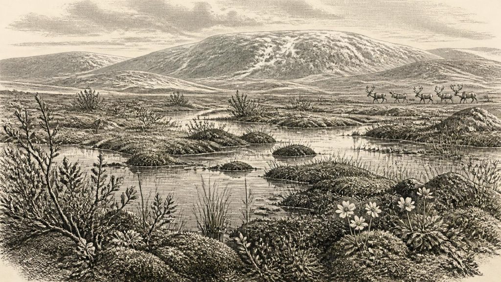
The date 30,519 BCE is a modern, imprecise conversion rather than a recorded Irish historical year. Evidence from Derryvree, County Fermanagh, documents an ice-free interval between glacial advances, represented by freshwater silts beneath till. Bogbean, water-milfoil, dwarf willow, mountain avens and insects indicate cold, open tundra wetland with seasonal water. Castlepook Cave, County Cork, preserves bones from varied periods, including mammoth, giant deer, reindeer, predators and lemmings, demonstrating episodic cold-stage fauna. A possibly cut-marked reindeer bone may suggest human activity, but proves neither settlement nor occupation. Ireland’s reconstructable history is environmental: fluctuating ice, changing habitats and intermittent life across regions.
Dateline
The label 30,519 BCE cannot identify an eventful year in Irish history. It is a modern calendar conversion, roughly 32,468 years before the conventional radiocarbon ‘present’ of AD 1950, not a date that Ice Age inhabitants could have recognised or recorded. No written calendar, named people, ruler, settlement or political boundary is recoverable for Ireland at this depth of time. Modern calendar-year precision is unavailable. What can responsibly be described is a wider Late Pleistocene landscape, reconstructed from stratified sediment, plant remains, insects, animal bones, ice-sheet evidence and radiocarbon ranges.
In archaeological and climatic terms, this point falls within Marine Isotope Stage 3, a highly variable phase of the last Ice Age. Ireland was approaching the long period in which the British-Irish Ice Sheet expanded towards its later maximum, but conditions were neither uniform across the island nor stable over centuries. The most relevant evidence comes from an ice-free interval recorded at Derryvree near Maguiresbridge, County Fermanagh, and from the remarkable animal-bone archive of Castlepook Cave near Doneraile, County Cork. Neither source is a record for one numbered year; together they offer a responsible outline of Ireland’s cold, intermittently habitable environments.
A Date Measured in Ranges
The distinction between a radiocarbon age and a calendar date is crucial. At Derryvree, organic silts and fine sands yielded the determination Birm-166: 30,500 radiocarbon years before present, with a large quoted uncertainty of +1,170 and −1,030 years. That measurement dates organic material in a deposit, not a historical episode. Because atmospheric radiocarbon levels changed substantially during the Ice Age, such results must be calibrated against internationally maintained curves. Published discussion places the Derryvree evidence broadly within a calibrated span of approximately 36,900–31,700 years before present. The modern label 30,519 BCE lies within that wide window, but it cannot be assigned to a particular layer, season, animal death or human action.
That uncertainty is not a weakness to be concealed; it is part of the evidence. The deposit accumulated over time in changing environmental conditions, while later glacier ice sealed it beneath till. Its value lies precisely in showing that this locality stood free of overriding ice long enough for freshwater, plants, invertebrates and organic sediment to gather. It offers a rare glimpse between episodes of glaciation, rather than a frozen snapshot of all Ireland.
Freshwater Beneath a Drumlin
Derryvree was exposed during road works in 1969 in the drumlin country of County Fermanagh. The sequence was striking: a lower layer of glacial till, then freshwater silts and fine sands rich in organic remains, followed by an upper till. Till is sediment laid down directly by ice, usually unsorted and mixed in texture. The intervening bed therefore records an interval after one advance of glacier ice and before another. It is compelling evidence for local ice-free conditions, though not proof that all of Ireland was simultaneously free from ice.
The biological remains describe a cold, open, largely treeless setting. Pollen, mosses, seeds and other plant macrofossils point to tundra or muskeg-like wet ground: waterlogged places with sedges and mosses, shallow pools and exposed mineral soils. Fossils include dwarf willow, mountain avens, bogbean and water-milfoil. Bogbean and water-milfoil are especially useful because they demonstrate freshwater conditions, at least seasonally, rather than an uninterrupted frozen desert. Dwarf willow and mountain avens show that plants adapted to cold, wind-exposed terrain survived in the district. Insect evidence adds to the picture of a periglacial environment shaped by frost, thaw and short productive summers.
This was not a modern Irish landscape merely made colder. There were no hedgerows, fields, enclosed farms, peat-cuttings, roads or woodland cover comparable with later Ireland. Vegetation would have been low and patchy, responding closely to drainage, shelter, snow cover and soil disturbance. Pools and wet margins could be biologically rich during the growing season, even while nearby ground experienced severe frost and permafrost-related processes. The apparent contradiction between liquid water and glacial conditions is central to the site: harsh climates can still sustain local wetlands during summer thaw or in unfrozen watercourses.
Ice at the Horizon
The Derryvree sediments are also evidence of regional change. The lower and upper tills show that glacier ice affected the area both before and after the freshwater interval. Broader reconstructions of the British-Irish Ice Sheet indicate that major expansion was under way after roughly 35,000–32,000 years ago, with the later maximum conventionally placed around 27,000–21,000 years ago. Around the notional date represented by 30,519 BCE, Ireland’s environments were thus vulnerable to rapid change as climate cooled and ice centres grew. But the exact route, thickness and timing of particular ice advances remain matters of reconstruction, not annual historical fact.
The landscape was also geographically different from the familiar island map. Global sea levels were lower during the Ice Age, coastlines lay beyond many modern shores, and ice, exposed seabed and changing channels altered possible routes for animals. Yet the evidence does not justify a simple claim that Ireland possessed a permanent, easy land bridge to Britain or continental Europe at this particular moment. The movements of animals were shaped by changing ice margins, sea levels and habitats over long periods. Their presence proves that dispersal occurred at some stages; it does not reveal one fixed route or a single migration event.
Castlepook’s Animal Archive
For the wider ecological world, Castlepook Cave is indispensable. The limestone cave system near Doneraile is Ireland’s richest known pre-Last Glacial Maximum vertebrate site. Excavations conducted mainly between 1904 and 1918 recovered more than 2,000 bones. Direct radiocarbon dates from individual bones span a long interval, broadly from about 45,700 to 19,950 years before present. The collection includes woolly mammoth, giant deer, reindeer, brown bear, wolf, Arctic fox and spotted hyena, alongside small mammals such as Norwegian and collared lemmings.
These remains should not be arranged into a single imaginary herd roaming Cork in 30,519 BCE. The cave was a repository used and altered over repeated episodes. Carnivores brought in or modified bones; water moved sediment; natural deaths and collapses complicated the record; and much of the material was recovered before modern excavation methods could record every association. The fauna nevertheless establishes an important point: during suitable phases of the later Pleistocene, parts of Ireland supported, or were visited by, a striking range of cold-stage mammals. Reindeer and lemmings suggest open, cold country; mammoth and giant deer point to productive grazing and browsing landscapes; wolves and hyenas demonstrate a predator and scavenger community unlike any in Ireland today.
A reindeer femur from Castlepook has attracted particular attention because it bears a mark interpreted as a possible cut made by a sharp stone tool. If that interpretation is sustained, it may be evidence that people processed an animal in Ireland far earlier than the long-established terminal-Pleistocene human record. The claim is important but necessarily cautious. The bone is not from a securely excavated occupation floor with a hearth, stone-tool assemblage, dwelling, repeated food debris or human remains. Its date concerns the animal bone, not a calendar moment for the mark. It is evidence for a possible act of carcass processing, not proof of a permanent settlement, a named hunting group or continuous occupation.
No Polities, No Proven Economy
There is therefore no responsible history of Irish political affairs, diplomacy, organised warfare, law, religious institutions or learned culture for this date. There are no chiefs, tribes, shrines, graves, houses or artefacts securely attributable to 30,519 BCE. Nor can historians infer trade networks, farming, livestock keeping or a settled economy from the environmental record. The Derryvree wetland and Castlepook fauna are not evidence for villages. They show conditions in which plants and animals lived, and perhaps in which occasional people may have moved, hunted or scavenged.
That absence matters because later prehistoric categories can distort the distant past. An Ice Age visitor, if people were present, would have faced a mobile world of seasonal resources, exposed ground, dangerous carnivores and shifting access routes rather than a mapped country of territories and communities. Such a possibility is interpretation, however, not a documented social fact. The firmer conclusion is that the evidence remains environmental and episodic. Its scale is the pool, the cave passage, the migrating animal and the advancing ice margin.
An Uneven Pleistocene Ireland
Ireland around this point in deep time was neither permanently buried beneath ice nor securely hospitable throughout. At Derryvree, freshwater sediments and cold-adapted plants document an interval of open tundra wetland between glacial advances. At Castlepook, bones reveal that large herbivores, predators and scavengers reached southern Ireland during the broader middle-to-late Ice Age. These sites illuminate different places and spans of time, not an exact national scene. Their joint lesson is one of unevenness: pockets of seasonal life existed amid a climate system capable of remaking the landscape.
The most historically meaningful development was thus environmental. Glacial expansion, frost, water and ecological movement set the limits within which any animal—and potentially any human visitor—could exist. The bogbean seed beneath Fermanagh’s later till is modest evidence, but it carries a powerful message: even in a severe Ice Age world, freshwater habitats persisted locally, were colonised by specialised plants and insects, and were later overwhelmed by returning ice. That is the responsible history available for 30,519 BCE: not an invented event, but a carefully bounded reconstruction of Ireland before written memory.
Primary Sources
- A Middle Midlandian Freshwater Series at Derryvree, Maguiresbridge, County Fermanagh, Northern Ireland
- Figure 6.— The Subdivision of the Quaternary Period in Ireland
- The IntCal20 Northern Hemisphere Radiocarbon Age Calibration Curve (0–55 cal kBP)
- The IntCal20 Approach to Radiocarbon Calibration Curve Construction: A New Methodology Using Bayesian Splines and Errors-in-Variables
- IntCal
- BSBI: Menyanthes trifoliata
- BSBI: Salix herbacea
- BSBI: Dryas octopetala
- BSBI: Myriophyllum alterniflorum
- Castlepook Cave, County Geological Site Report
- Heritage Artefacts of County Cork
- The Exploration of Castlepook Cave, County Cork
- Occurrence of Mammalia Relicts at Site Castlepook Cave
- The Irish Quaternary Fauna Project
- New Insights on the Fauna of Ireland's Younger Dryas and Early Holocene from Alice & Gwendoline Cave
- Extent and Timing of the Last Glacial Maximum (LGM) in Britain and Ireland: A Review
- The Deglaciation of the Western Sector of the Irish Ice Sheet from the Inner Continental Shelf to its Terrestrial Margin
- Early Deglaciation of Western Ireland
- Exploring Controls of the Early and Stepped Deglaciation on the Western Margin of the British-Irish Ice Sheet
- Dimensions and Chronology of the Last Ice Sheet in Western Ireland
- Deposits of the Last Glaciation
- NGRIP/GRIP Data, Greenland Ice Core Chronology 2005
