
Maguirebridge’s Lost Freshwater Basin30537 BCE
About 30,537 BCE, Ireland was an unstable Late Pleistocene landscape, not a precisely datable historical moment. Expanding ice, lower sea levels and variable regional conditions produced a mosaic of glacial, periglacial and open wetland environments. At Derryvree near Maguiresbridge, organic freshwater sediments between tills indicate a tundra-like, mossy basin during an interval between ice advances, though radiocarbon dating permits only a broad mid-35,000s calibrated age. Castlepook Cave preserves remains of cold-adapted mammals, demonstrating intermittent habitable open country. A marked reindeer bone may indicate brief human butchery, but does not prove settlement. No evidence supports polities, trade, or continuous human occupation.
Dateline
The label 30,537 BCE gives a misleading impression of precision. No community in Ireland recorded a year at this date, and archaeology cannot identify an event, ruler, journey or seasonal episode that happened in that particular calendar year. In modern chronological terms it falls roughly 32,500 years before AD 1950, within the Late Pleistocene and Marine Isotope Stage 3. That conversion is useful only as orientation. Evidence from this depth of time comes with wide uncertainties, and radiocarbon ages must be calibrated rather than read as calendar dates. Ireland around this point is therefore best approached as a changing Ice Age landscape, not as a conventional historical year.
A Landscape in Transition
This was well before the Last Glacial Maximum, when the British–Irish Ice Sheet reached its widest extent around 26,000 years ago. Yet it was not an age of stable conditions. Ice masses waxed and waned across the Irish–British region, while temperatures, snowfall, sea level and vegetation altered on scales of centuries and millennia. Modern reconstructions suggest that ice was beginning to expand in some northern and upland sectors of Ireland and Britain during the broader period around 31,000–30,000 years ago. They do not, however, allow a secure map for every part of Ireland at 30,537 BCE.
That limitation matters. One should not picture the whole island as either a uniform white ice sheet or a wholly open hunting ground. Conditions varied sharply by region, altitude and time. In parts of the north, advancing ice and its meltwater could reshape valleys and lowlands. Elsewhere, exposed ground, thin seasonal snow, frozen soils, ponds and sediment-laden streams may have formed a patchwork. The familiar modern coastline did not exist: global sea level was substantially lower than today, exposing broad areas of continental shelf. But lower sea level did not automatically create a simple dry route from Britain or continental Europe to Ireland. The changing Irish Sea basin, local ice margins and remaining marine channels make any supposed land bridge uncertain.
Derryvree’s Buried Wetland
The strongest Irish environmental evidence relevant to this general phase comes from Derryvree, near Maguiresbridge in County Fermanagh. Roadworks in 1969 cut through a drumlin and revealed a remarkable sequence. A freshwater layer of silts and fine sands, containing organic remains, lay between two thick tills: sediments deposited directly or indirectly by glacial ice. The order of deposits is secure. An earlier ice advance had affected the locality; a freshwater environment then developed; later ice overrode or buried it beneath a further till sheet.
Organic material from the freshwater deposit, sample BIRM-166, produced a conventional radiocarbon result of 30,500 years BP, with a substantial quoted uncertainty of +1,170/−1,030 years. “BP” means before AD 1950 and is not the same thing as a calendar age. Later calibrations place the deposit broadly in the mid-30,000s calibrated years BP, rather than at one exact historical year. Consequently, Derryvree cannot be claimed as a snapshot of 30,537 BCE. It is nonetheless an indispensable local window onto the colder, ice-sensitive world that preceded the final great expansion of the Irish ice sheet.
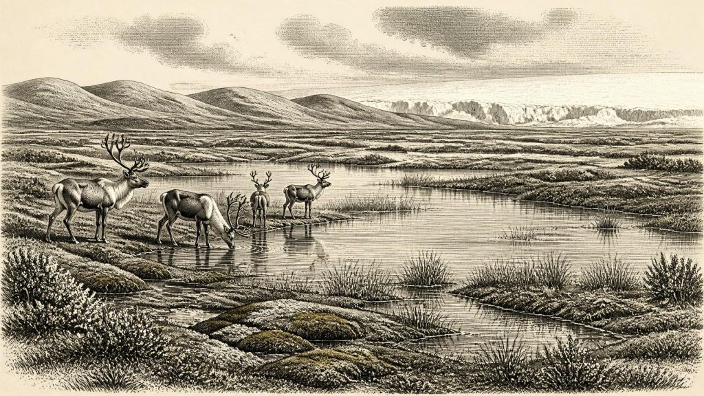
The sediments contained plant and small-animal evidence consistent with open tundra or muskeg: wet, mossy ground with shallow pools, sedges and cold-adapted vegetation rather than forest. The original investigators identified a periglacial regime, meaning a climate governed by severe frost and seasonal thaw at the edge of glacial conditions. Such terrain was not lifeless. Freshwater plants and mosses occupied the water margins; insects and other small animals exploited plant-rich sediments; and short summer growing seasons could briefly transform low hollows into productive wetlands. But it was an austere environment, with long winters and little shelter from wind.
Animals of the Open Country
Caves in southern Ireland provide a different form of evidence. Castlepook Cave, also called Mammoth Cave, near Doneraile in north County Cork, has produced Ireland’s most important pre-Last-Glacial-Maximum mammal assemblage. Direct radiocarbon dating and later reassessment of cave collections indicate that a varied fauna reached Ireland during intervals between at least about 45,000 and 20,000 years ago. The cave record includes woolly mammoth, reindeer, giant deer, brown bear, wolf, Arctic fox, mountain hare, lemmings and spotted hyaena.
These animals should not be treated as though they all stood together in one herd at one moment. Cave deposits accumulate over long periods, and bones can be moved by carnivores, water, collapse and excavation. The older Castlepook collection was also recovered before modern standards of stratigraphic recording. Nevertheless, the fauna demonstrates that Ireland could support, at different times within this broad cold-stage interval, a mixture of grazing animals, browsers, scavengers and predators characteristic of open northern Eurasian environments. Reindeer were especially suited to seasonal, treeless country; hyaenas and wolves reveal a competitive carnivore landscape; mammoth remains point to the presence of extensive open habitat somewhere within the wider region.
For people, such a landscape would have offered opportunities but few guarantees. Animal movements, carcasses, fishable waters and summer plant foods could sustain mobile foragers briefly. Winter exposure, unpredictable weather and the great distances between sheltered places would have imposed formidable limits. This is an interpretation based on analogous Upper Palaeolithic lifeways and the Irish environmental record, not direct evidence for an established Irish population.
The Human Question
Castlepook has also produced the most provocative possible human trace for this era: a reindeer femur bearing a deep mark interpreted by zooarchaeologist Ruth Carden as damage from a sharp stone tool during butchery. County Cork heritage material presents the object as a Palaeolithic reindeer bone of about 31,000 BC, and public reporting has described its radiocarbon age as roughly 33,000 years. If the mark was made by a tool on fresh bone, it would show that people handled a reindeer in Ireland far earlier than the long-established record of post-glacial settlement.
The conclusion must remain restrained. The bone comes from an old cave collection, not a newly excavated, intact camp floor with a hearth, stone tools, refitting bones, shelter remains or human burials. The date measures the death of the reindeer, not necessarily the precise moment of butchery. Nor does one marked bone establish a permanent settlement, a named culture, a migration route or continuous descent to later inhabitants. Around 30,537 BCE, the responsible formulation is that Ireland may have received brief visits by Upper Palaeolithic people during favourable intervals, but secure evidence for a resident community has not been demonstrated.
No Polities, No Proven Trade
There is no evidence here for political affairs, diplomacy, warfare, chiefs, territories or institutions. Nor is there evidence for trade in the historical sense. A possible hunting or carcass-processing visit at Castlepook would suggest subsistence activity, not commercial exchange. Stone tools, if any were used, have not been recovered in an associated assemblage from the cave, so their raw material, place of manufacture and route into Ireland cannot be established. It would be equally unsafe to assign language, ethnicity or tribal identity to any possible visitors.
Religion, art and formal learning are similarly beyond the Irish evidence for this date. Upper Palaeolithic peoples elsewhere in Europe created art, ornaments, burial practices and complex technical traditions, but none can be projected automatically across the Irish Sea. The absence of such evidence in Ireland may reflect real absence, brief occupation, later glacial destruction or the scarcity of surviving and excavated sites. It does not prove that any visitors lacked culture; it simply marks the boundary between what the evidence supports and what it does not.
An Archive Beneath Later Ice
The principal development relevant to this date was environmental rather than political: Ireland was moving through an unstable cold phase towards much more extensive glaciation. Derryvree preserves the counter-intuitive fact that an ice-free freshwater hollow could exist between episodes of ice cover. Castlepook preserves the complementary fact that large mammals entered or survived in Ireland during parts of the same broad Ice Age world. Together, these sites replace older, simpler pictures of an island either continuously frozen or continuously habitable.
At 30,537 BCE, then, there is no recoverable annual narrative. There is instead a carefully bounded reconstruction: a low-sea-level north-west European setting; a landscape increasingly influenced by expanding ice; locally open, treeless and wet ground in some intervals; cold-adapted animals moving through parts of Ireland; and a tantalising but unconfirmed possibility of fleeting human activity. The most important historical lesson is methodological. Ireland’s deepest past is written not in chronicles but in layers of silt, pollen, insects, bones and till—evidence powerful enough to reveal an Ice Age world, but not precise enough to turn it into a dated event.
Primary Sources
- A Middle Midlandian Freshwater Series at Derryvree, Maguiresbridge, County Fermanagh, Northern Ireland
- A Reconsideration of the Radiocarbon Dating of the Marine Isotope Stage 3 Fauna from Southern Ireland
- The Irish Quaternary Fauna Project
- Growth and Retreat of the Last British–Irish Ice Sheet, 31,000 to 15,000 Years Ago: the BRITICE-CHRONO Reconstruction
- Exploring Controls of the Early and Stepped Deglaciation on the Western Margin of the British Irish Ice Sheet
- Irish Pleistocene Biostratigraphy
- Figure 6: The Subdivision of the Quaternary Period in Ireland
- The IntCal20 Northern Hemisphere Radiocarbon Age Calibration Curve (0–55 cal kBP)
- IntCal20 Northern Hemisphere Radiocarbon Age Calibration Curve PDF
- IntCal: International Radiocarbon Calibration
- Heritage Artefacts of County Cork
- The Last Scottish Ice Sheet
- Trimlines, Blockfields and the Vertical Extent of the Last Ice Sheet in Southern Ireland
- Last Glacial Maximum Cirque Glaciation in Ireland and Implications for Reconstructions of the Irish Ice Sheet
- A Stratigraphic Investigation of the Celtic Sea Megaridges Based on Seismic and Core Data from the Irish-UK Sectors
- The Irish Pleistocene Biostratigraphy
- The Irish Quaternary Fauna Project PDF
- A Palaeo-Glaciological Reconstruction of the Last British-Irish Ice Sheet
- The Geological Heritage of County Leitrim
- Introduction to the Glacial Sand and Gravel Landscapes of Northern Ireland
