

Fermanagh’s Silt Interval31868 BCE
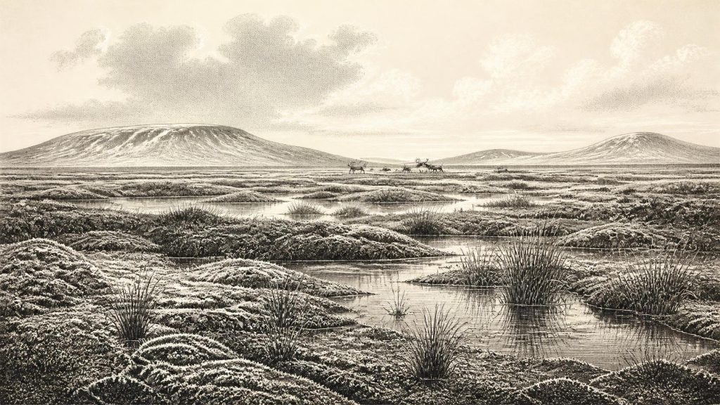
Around 31,868 BCE, Ireland lay in the unstable later Marine Isotope Stage 3, as the British–Irish Ice Sheet expanded unevenly. Derryvree, County Fermanagh, preserves freshwater silts between tills, recording an ice-free, sedge-rich tundra wetland later buried by advancing ice. Castlepook Cave, County Cork, contains a complex fauna including mammoth, giant deer, reindeer, predators and cold-adapted species, indicating productive open landscapes during favourable intervals. Butchery marks on a reindeer femur may represent Ireland’s earliest human activity, but cannot prove settlement or continuity. Changing climate, sea levels and ice margins made access and survival precarious. Evidence supports intermittent opportunity, not permanent occupation.
Dateline
“31,868 BCE” is a useful modern label, not a date at which anyone in Ireland could have marked a year. This was long before calendars, writing, named communities or even securely documented settlement on the island. At this depth of time, archaeological chronology works with radiocarbon determinations, calibrated ranges, cave deposits and climatic stages rather than annual precision. The point represented by this entry lies within the later part of Marine Isotope Stage 3 (MIS 3), a fluctuating phase of the Last Glacial Period. The responsible question is therefore not what happened in Ireland in one particular year, but what the surviving evidence can reveal about conditions broadly around 34,000–32,000 calibrated years before present.
A Landscape Between Ice Advances
Ireland was not then the familiar green, wooded island of later prehistory. Its climate was cold, but not simply and permanently frozen. MIS 3 was marked by sharp climatic oscillations: relatively milder interstadials alternated with severe stadials. In western Europe these changes could occur on timescales much shorter than conventional historical periods. A date around 31,868 BCE therefore belongs to an unstable environmental threshold, as the British–Irish Ice Sheet was expanding towards the far greater extent it would achieve later in the glacial cycle.
Recent reconstructions of the ice sheet stress that its growth was regionally uneven. Around 31,000 years ago, ice was accumulating over high ground in northern Ireland, while other Irish regions were subject to changing local ice margins, periglacial conditions or open ground. By about 30,000 years ago, the wider British–Irish Ice Sheet had expanded rapidly in several sectors. This does not mean that every valley and lowland in Ireland was simultaneously buried beneath ice at the moment represented by this article. It means that the island’s habitable patches, waterways, coastlines and animal corridors were being reshaped by advancing ice, cold winds, seasonal thaw and falling sea level.
Lower sea level exposed land now submerged around Ireland’s coasts and enlarged the surrounding continental shelves. Yet this should not be turned into a simple image of a broad, dependable land bridge to Britain or continental Europe. Shorelines, marine channels, glacier margins and the practicality of crossings changed through time. The routes by which large mammals entered Ireland remain a matter for reconstruction from faunal distributions, sea-level history and glacial geography, rather than direct observation. For people, if they were present, the crossing problem was still more demanding.
Derryvree’s Buried Wetland
The clearest environmental evidence relevant to this period comes from Derryvree near Maguiresbridge in County Fermanagh. Road works in 1969 cut through a drumlin and exposed freshwater silts and fine sands trapped between two substantial layers of glacial till. That sequence matters because the organic deposit was laid down during an interval when the locality was not overwhelmed by ice, then was sealed beneath a later advance. It is an unusually direct glimpse of an Irish landscape that existed between glacial episodes.
A radiocarbon determination from the Derryvree organic material was reported as 30,500 radiocarbon years before present, with a substantial uncertainty. When expressed through modern calibration, the deposit has been placed broadly within a range of roughly 36,900–31,700 calibrated years before present. The modern year-label 31,868 BCE falls near the younger end of that range, but it cannot identify a single season, generation or event in the deposit. Calibration is essential: radiocarbon years are not identical to calendar years, and the calibration curve becomes less precise and more complex this far back in time.
The plants and small animals preserved in the silts indicate open tundra and a periglacial regime. The old description of a “muskeg” environment conveys a wet, sedge-rich, waterlogged setting rather than a forested bog of the modern Irish imagination. Mosses, sedges and cold-adapted vegetation grew around shallow freshwater. The ground would have been subject to frost action, with long winters, brief growing seasons and exposed surfaces. There is no evidence here for the dense oak, elm and hazel woodland that would cover much of Ireland after the Ice Age. Derryvree instead preserves a northern landscape in which wet hollows and shallow water offered biological productivity amid a generally treeless terrain.
Animals at Castlepook
Southern Ireland contributes a different, complementary archive. Castlepook Cave near Doneraile in north County Cork has produced one of Ireland’s richest late-Pleistocene faunal collections. Its deposits are complicated: bones accumulated over long periods, some material was disturbed, and a cave is not a neutral snapshot of the land outside. Carnivores, water movement, collapse and earlier excavation can all mix or displace remains. For that reason, the cave cannot be read as a census of animals living together on one day.
Nevertheless, redating work has shown that important elements of the Castlepook fauna belong much earlier in MIS 3 than formerly believed. The broader assemblage includes woolly mammoth, giant deer, reindeer, brown bear, wolf, Arctic fox, mountain hare, stoat and small cold-adapted rodents, as well as spotted hyaena. Together, these species demonstrate that Ireland could support a varied Pleistocene mammal community during favourable intervals before the Last Glacial Maximum. Reindeer and lemmings point towards open, cold environments; mammoth and giant deer speak to extensive grazing landscapes; predators show that this was a functioning food web, not merely a scatter of wandering herbivores.
The most important humanly relevant object is a reindeer femur from Castlepook bearing marks interpreted as butchery damage. Improved radiocarbon work placed the bone in the broad timeframe of roughly 33,000 BCE, making it potentially the earliest evidence for human activity in Ireland by a considerable margin. Its significance is real, but its limits are equally important. One modified bone is evidence consistent with people processing an animal. It is not proof of a permanent settlement, a named population, a camp layout, a hunting territory or an uninterrupted ancestry leading to later Irish communities.
The Human Question
At around 31,868 BCE, Europe was inhabited by Homo sapiens communities with sophisticated hunting knowledge, mobile social networks and varied stone-tool traditions. It would be tempting to assign the Castlepook evidence to a familiar archaeological culture or to imagine a group of reindeer hunters establishing an Irish homeland. The Irish evidence does not support that level of certainty. No securely associated lithic assemblage, hearth, dwelling, human burial or repeated occupation surface from this time has yet been demonstrated at Castlepook.
The careful interpretation is narrower and more powerful: people may have reached Ireland during a relatively accessible MIS 3 interval and processed at least one reindeer there. Whether they came as a small, short-lived hunting party, visited repeatedly, or formed part of a more extensive but archaeologically invisible population remains unknown. The subsequent advance of ice would have destroyed, buried or displaced many traces of open-air activity. That geological history helps explain the scarcity of evidence, but it cannot fill the gaps with certainty.
There is therefore no basis for describing political affairs, diplomacy, tribes, leaders or warfare in Ireland at this date. Nor is there evidence for formal religion, monuments, art, literacy or institutions. Silence in these categories is not a claim that early people lacked social lives, beliefs or learning; mobile hunter-gatherers elsewhere certainly possessed rich social knowledge and cultural practices. It is simply an acknowledgement that the Irish record around this date has not preserved evidence from which such particulars can responsibly be inferred.
Food, Movement and Risk
If the marks on the Castlepook reindeer femur do record human butchery, they offer the smallest but most tangible indication of economy: the acquisition and processing of animal food. Reindeer would have supplied meat, marrow, fat, hide, sinew and bone. In a cold, exposed environment, such resources had practical value beyond a single meal. Yet the bone does not reveal whether the animal was hunted, found dead, taken from another predator, or processed by one person rather than a group. It cannot establish seasonal movement, methods of weaponry or ownership of territory.
More securely, the animal remains show an economy of nature rather than farming. There were no crops, domestic livestock, villages, fields, metal objects or long-distance commercial systems in Ireland known from this horizon. Any humans present would have depended upon careful mobility, local ecological knowledge and the shifting availability of large game, small mammals, freshwater and shelter. Cave entrances could provide temporary protection, but Castlepook’s role as a carnivore-affected bone repository warns against assuming it was necessarily a human home.
A Fragile Presence
The central development illuminated by Ireland around 31,868 BCE is not a political event but a conjunction of environmental opportunity and vulnerability. Derryvree records ice-free tundra wetland in Fermanagh; Castlepook records a southern animal community adapted to open glacial landscapes; Irish cave calcite from Crag Cave shows that milder episodes during MIS 3 were sufficiently significant for liquid water and speleothem growth. These archives demonstrate that the Irish landscape was neither uniformly ice-covered nor environmentally static.
They also explain why any human presence was precarious. Climatic improvement could open routes and create productive habitats, only for colder conditions and advancing ice to close them again. The evidence presently available suggests possibility, not continuity. The first securely traceable long-term human settlement of Ireland belongs much later, after the Last Glacial Maximum. Around 31,868 BCE, Ireland appears instead as a cold, changeable edge of north-western Europe: a place where reindeer ranged, hyaenas used caves, wetlands formed beneath later drumlins, and perhaps a small number of people briefly entered a landscape that would soon be transformed again by ice.
Primary Sources
- A Reconsideration of the Radiocarbon Dating of the Marine Isotope Stage 3 Fauna from Southern Ireland
- Middle Midlandian Freshwater Series at Derryvree, Maguiresbridge, County Fermanagh, Northern Ireland
- Episodic Speleothem Deposition Tracks the Terrestrial Impact of Millennial-Scale Last Glacial Climate Variability in SW Ireland
- The Irish Quaternary Fauna Project
- Growth and Retreat of the Last British–Irish Ice Sheet, 31,000 to 15,000 Years Ago: The BRITICE-CHRONO Reconstruction
- The Timing and Magnitude of the British–Irish Ice Sheet Between Marine Isotope Stages 5d and 2
- The IntCal20 Northern Hemisphere Radiocarbon Age Calibration Curve (0–55 cal kBP)
- Marine20—The Marine Radiocarbon Age Calibration Curve (0–55,000 cal BP)
- New Insights on the Fauna of Ireland's Younger Dryas and Early Holocene from Alice & Gwendoline Cave
- Castlepook Cave, County Geological Site Report
- Heritage Artefacts of County Cork
- Middle Midlandian Freshwater Series at Derryvree, Maguiresbridge, County Fermanagh, Northern Ireland
- Episodic Speleothem Deposition Tracks the Terrestrial Impact of Millennial-Scale Last Glacial Climate Variability in SW Ireland
- Growth and Retreat of the Last British-Irish Ice Sheet, 31,000 to 15,000 Years Ago
- Figure 6: The Subdivision of the Quaternary Period in Ireland
- IntCal Publications
- IntCal Data
- Mammals: National Museum of Ireland Natural History Collections
- Castlepook Cave Excavation, County Cork, 2022
- Ireland: Submerged Prehistoric Sites and Landscapes
- Stratigraphic and Palaeo-Geomorphological Evidence for the Glacial-Deglacial History of the Last British-Irish Ice Sheet in the North-Western Irish Sea
- Growth and Decay of a Marine-Terminating Sector of the Last British-Irish Ice Sheet: A Geomorphological Reconstruction
- Biogeography of Ireland: Past, Present, and Future






