

Maguirebridge’s Treeless Wetland31753 BCE
Around 33,700 years before 1950, during the volatile later Marine Isotope Stage 3, Ireland’s conditions cannot be reconstructed for a single calendar year. Derryvree near Maguiresbridge preserves organic silts beneath till, showing that an ice-free locality supported cold, treeless wetlands before later glaciation. Castlepook Cave’s mixed, long-accumulated fauna demonstrates links with north-west European Ice-Age environments, but cannot prove all species coexisted. A modified reindeer femur may indicate the earliest human butchery in Ireland, although it provides no evidence of settlement. Overall, fragmentary glacially altered records suggest habitable open landscapes, large mammals, and possible transient foragers, while emphasising substantial uncertainty throughout.
Dateline
31,753 BCE is a modern, proleptic calendar label, not a date that anyone in Ice-Age Ireland could have recognised or recorded. It corresponds only approximately to 33,700 years before AD 1950, the conventional ‘present’ used in radiocarbon and Quaternary studies. No excavation, climate archive or fossil deposit can identify an event in this particular year. The responsible scale is therefore the later part of Marine Isotope Stage 3 (MIS 3), a volatile interval of the Last Glacial period. For Ireland, the evidence consists not of annals, settlements or named peoples, but of cave bones, buried wetland sediments, pollen, plant remains, landforms and the subsequent effects of advancing ice.
A Date Within a Long Cold Phase
The numbered year falls well before the Last Glacial Maximum, conventionally dated at about 26,500–19,000 calibrated years before present (cal BP), when the British–Irish Ice Sheet reached its greatest overall extent. It should not, however, be imagined as a mild prelude to an otherwise distant ice age. MIS 3 was marked by abrupt climatic oscillations across the North Atlantic world, and Irish conditions changed over centuries and millennia. Some districts may have held small glaciers or expanding ice masses while others retained ice-free ground, freshwater hollows and open vegetation. The exact outlines of ice at roughly 33.7 ka BP remain uncertain, because later glaciers eroded, buried and rearranged much of the earlier landscape.
Older Irish schemes gave names such as the Derryvree Cold Phase to part of this pre-maximum cold interval. Such labels remain useful shorthand for particular bodies of evidence, but they are not securely bounded island-wide climatic episodes. Nor should they suggest that the whole country experienced one uniform weather regime. The Irish Ice Sheet was dynamic, responding to changing snowfall, temperature, sea level and ocean conditions. Modern reconstructions have greatly improved knowledge of its later growth and retreat, but they also underline how difficult it is to draw a precise map for an individual millennium, much less for one calendar year.
Derryvree Beneath the Drumlins
The most informative environmental evidence relevant to this broad moment comes from Derryvree near Maguiresbridge in County Fermanagh. There, organic silts were found beneath glacial deposits and between tills. Their position is crucial: the sediments accumulated during an interval when there was biologically active ground and freshwater in the locality, then were sealed beneath ice-related material during a later advance. They are not a snapshot of all Ireland, but they disprove any simple picture of an island continuously entombed beneath an unbroken ice sheet throughout the period.
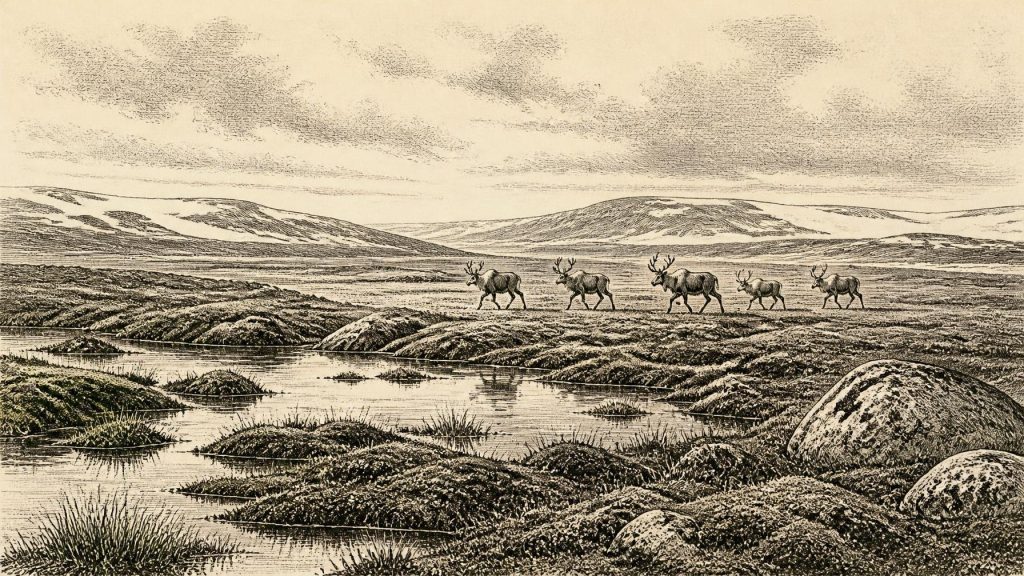
Plant evidence from the Derryvree deposits points to a cold, open and treeless wetland landscape, often described as muskeg or tundra-like marsh. Mosses, sedges and other wet-ground plants could grow around shallow water and saturated soils. Such a setting would have been low in stature, exposed to wind and seasonally severe rather than wooded like modern Fermanagh. It tells us that, at least during the time represented by the deposit, freshwater habitats persisted in an ice-free locality. It does not tell us the temperature on a particular day in 31,753 BCE, the length of every season, or whether the same vegetation covered Cork, Connacht or the eastern lowlands.
This distinction matters because organic layers beneath till are unusually valuable but inherently fragmentary. A wet hollow preserves pollen, seeds and fine sediments that uplands usually lose to erosion. Conversely, it records its own drainage basin rather than an entire island. The later passage of ice both protected Derryvree’s silts from surface weathering and made comparable sites scarce. Ireland’s apparent archaeological silence at this date is therefore partly a story of preservation: the glacial landscape removed evidence as well as creating the drumlins, erratics and scoured rock that remain visible today.
Animals at Castlepook
In southern Ireland, Castlepook Cave near Doneraile, County Cork, provides the richest known archive of pre-Last Glacial Maximum vertebrates. The cave system has yielded remains attributed to reindeer, mammoth, brown bear, spotted hyaena, giant deer, wolves, Arctic foxes and lemmings. Taken together, the assemblage demonstrates that Ireland was connected ecologically to the broader north-west European Ice-Age world. Open country capable of supporting grazing animals existed at different times, while predators and scavengers used caves or encountered carcasses within the surrounding landscape.
Yet Castlepook is not a single living community preserved in stone. The bones came from different chambers, sedimentary settings and dates. Some were probably carried in by carnivores; some may reflect animals falling into or sheltering in the cave; water movement also disturbed and re-sorted material. Earlier excavations, undertaken before modern recording standards, removed large quantities of bone with limited contextual information. Radiocarbon programmes have shown that Castlepook’s fauna accumulated over a long span of MIS 3 and later cold phases, not during one season or even one generation. Reindeer are particularly relevant to the open, cold environments of the broad period, but no responsible account can claim that a known herd was passing the Awbeg Valley in this exact year.
Re-dating has also changed the story. Improved pretreatment and accelerator radiocarbon methods produced dates for some Castlepook specimens thousands of radiocarbon years older than results obtained in the 1990s. The revised work indicates that certain animals, including spotted hyaena and giant deer, may have disappeared locally before the Last Glacial Maximum, perhaps around 40,000 cal BP. This is a warning against compiling an imaginary, simultaneous menagerie. Animal presence is evidence for a sequence of changing habitats; it is not proof that every recorded species occupied Ireland at 33.7 ka BP.
The Reindeer Femur and People
A reindeer femur from Castlepook has made this period especially important for Irish archaeology. It has been presented as dating to about 33,000 years ago and bears a deep modification interpreted by zooarchaeologist Ruth Carden as a cut or chop made with a sharp stone tool during carcass processing. If that judgement is confirmed, it is potentially the earliest evidence for human activity in Ireland: not an abstract possibility of people nearby, but a trace of somebody handling a reindeer carcass.
The qualification is fundamental. The dated bone records when the animal died, not a conventional calendar year for human action. It derives from an old cave collection, not from a newly excavated, sealed occupation floor. No securely associated hearth, stone-tool assemblage, dwelling, burial or repeatedly used food-processing area of comparable age has yet been identified in Ireland. A single modified bone cannot establish how many people were present, where they came from, what language they spoke, whether they crossed by land, sea or ice-fringed coast, or whether they stayed beyond a short visit. It is best treated as significant but limited evidence for possible Upper Palaeolithic butchery.
Should humans have reached Ireland during this late-MIS-3 interval, the most defensible interpretation is of highly mobile foragers operating within a wider north-west European world, not a settled Irish population. Reindeer meat, marrow, hide, sinew and antler would all have been valuable resources, but none of these uses can be reconstructed in detail from the femur alone. The cave itself may not have been the place of killing or butchery; County Cork heritage interpretation has plausibly noted that carnivores or scavengers could have moved discarded remains into it. The search for undisturbed sediments and associated lithics at Castlepook is therefore more important than turning one bone into a complete social history.
No Politics, But a Human Landscape
There is no evidence from Ireland at this date for polities, chiefs, diplomacy, organised warfare, territorial boundaries, farming, trade networks, formal religion, monuments, writing or institutions. These are not subjects that archaeology has merely failed to name: the surviving evidence does not support their reconstruction. It would be misleading to project later Irish concepts of tribe, kingship, Celtic identity or sacred landscape into a period tens of millennia before the island’s securely documented post-glacial settlement.
There may nevertheless have been social life if the Castlepook interpretation is correct. Hunting and carcass processing normally involve knowledge: reading animal movement, making and maintaining stone tools, sharing food, assessing danger from predators and navigating an exposed terrain. Those are reasonable general inferences from Palaeolithic lifeways elsewhere, but they remain inferences, not observations of a particular Irish camp. No artefact securely demonstrates what technical traditions were present in Ireland, and no human remains identify the visitors.
Economically, the landscape offered wild animal resources and local stone, water and shelter, but it offered no evidence of cultivation or herding. Exchange is equally unproven. Lower sea levels altered coastlines and exposed land on parts of the continental shelf, yet the Irish Sea region was affected by changing marine conditions and ice-sheet behaviour. It cannot safely be reduced to a simple land bridge that people or animals certainly crossed at will. Connections with Britain and continental Europe were environmentally possible in various ways over long periods; the route used by any potential visitors to Ireland around this time is unknown.
A Record of Possibility
For 31,753 BCE, Ireland’s history is therefore environmental first and human only tentatively. Derryvree offers evidence of a treeless, wet, cold and living landscape later overridden by ice. Castlepook preserves an uneven archive of Ice-Age animals and a reindeer bone that may retain the mark of human butchery. Together they show an island or near-island region at the edge of major climatic and geographical change, not an empty stage but a poorly preserved one. The central fact is uncertainty disciplined by evidence: around 33,700 cal BP, parts of Ireland could sustain tundra wetlands and large mammals, while the possibility of fleeting human presence is now stronger than it once was, but still falls far short of proof of enduring settlement.
Primary Sources
- A Reconsideration of the Radiocarbon Dating of the Marine Isotope Stage 3 Fauna from Southern Ireland
- The Irish Quaternary Fauna Project
- Irish Quaternary Vertebrates
- The Last Irish Ice Sheet: Extent and Chronology
- Advances in Irish Quaternary Studies
- Figure 6.— The Subdivision of the Quaternary Period in Ireland
- Cenozoic: Tertiary and Quaternary
- Heritage Artefacts of County Cork
- Archaeological Heritage of County Cork
- 2022:564 – Castlepook Cave, Castlepook South, Cork
- The Exploration of Castlepook Cave, Co. Cork
- Growth and Retreat of the Last British–Irish Ice Sheet, 31,000 to 15,000 Years Ago: The BRITICE-CHRONO Reconstruction
- Pattern and Timing of Retreat of the Last British-Irish Ice Sheet
- Timing and Pace of Ice-Sheet Withdrawal Across the Marine–Terrestrial Transition West of Ireland During the Last Glaciation
- Trimlines, Blockfields and the Vertical Extent of the Last Ice Sheet in Southern Ireland
- The Deglaciation of the Western Sector of the Irish Ice Sheet From the Inner Continental Shelf to its Terrestrial Margin
- Oscillating Retreat of the Last British-Irish Ice Sheet on the Continental Shelf Offshore Galway Bay, Western Ireland
- Stratigraphic and Palaeo-Geomorphological Evidence for the Glacial-Deglacial History of the Last British-Irish Ice Sheet in the North-Western Irish Sea
- The IntCal20 Northern Hemisphere Radiocarbon Age Calibration Curve (0–55 cal kBP)
- New Insights on the Fauna of Ireland’s Younger Dryas and Early Holocene From Alice & Gwendoline Cave
- The Human Colonisation of Ireland in Northwest European Context





