
The Maguiresbridge Freshwater Series31678 BCE
31,678 BCE is a modern label for a broad Late Pleistocene interval, reconstructed from environmental evidence rather than recorded events. At Derryvree, County Fermanagh, freshwater deposits between glacial tills reveal an ice-free or largely ice-free, periglacial tundra landscape with pools, sedges, mosses and sparse vegetation before renewed glaciation. Castlepook Cave, County Cork, preserves MIS 3 remains of reindeer, giant deer, mammoth, hyaena and other fauna, though accumulated over time. A possibly cut-marked reindeer bone suggests brief human presence, but occupation remains unproven. These archives show dynamic, regionally varied Ice Age Ireland, later extensively reshaped by expanding ice sheets over millennia.
Dateline
31,678 BCE is a modern chronological label, not a year that anybody living in Ireland could have named, recorded or commemorated. It corresponds approximately to 33,600 calendar years before AD 1950 and falls in the later part of the Late Pleistocene, broadly within Marine Isotope Stage 3 (MIS 3), an unstable interval of the last Ice Age. Modern calendar-year precision is not available at this depth of time. The responsible history of Ireland is therefore not an account of an event in one recoverable year, but a reconstruction from deposits, fossil bones, pollen, plant remains, insects, landforms and radiocarbon measurements with wide calibrated ranges.
A Date Within Broad Ranges
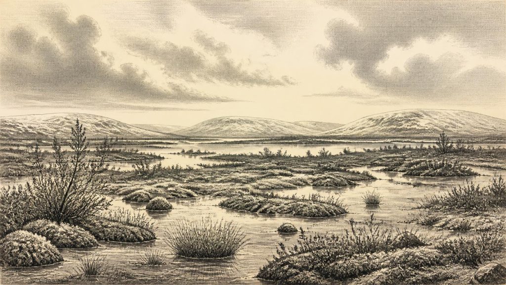
The closest Irish environmental evidence comes from Derryvree, near Maguiresbridge in County Fermanagh. Roadworks in 1969 cut through a drumlin and exposed freshwater silts and fine sands lying between two thick and distinct tills: sediments deposited directly by glacier ice. The order of those layers is crucial. Ice had first crossed the district; a period followed in which freshwater sediment and organic material accumulated in an ice-free or largely ice-free setting; then a later glacier advanced and sealed the evidence beneath another till sheet.
Organic material from the Derryvree deposits produced a radiocarbon age of 30,500, with an uncertainty of +1,170 and −1,030 radiocarbon years before present. Calibrated with modern curves, this belongs broadly to about 36,900–31,700 calibrated years BP. The nominal date of 31,678 BCE falls within that wide span, but it would be mistaken to claim that the silts describe that particular year, season or generation. A radiocarbon determination dates the death of sampled organic matter, while a sediment bed can represent a succession of episodes. The result is nevertheless strong evidence that part of northern Ireland sustained a cold freshwater landscape during this general period, before renewed glaciation.
Wet Tundra Beneath Later Ice
Derryvree’s pollen, plant macrofossils, mosses and insect remains indicate open tundra vegetation and a periglacial climate. “Periglacial” does not simply mean frozen solid: it describes landscapes intensely shaped by frost, thaw, seasonal waterlogging and short growing seasons near an ice-sheet environment. The local scene was likely a mosaic of shallow pools, silty water margins, sedges, mossy ground, low-growing herbs and sparse shrubs. Fossil evidence includes bogbean, water-milfoil and mountain avens, plants that help show that even a severe Ice Age landscape contained freshwater habitats and productive summer growth.
This was not a familiar Ireland of oak woodland, hedged fields and deep peat bogs. Nor was it necessarily an unbroken white wilderness. The evidence points instead to treeless open country, in which wet basins and exposed ground differed sharply over short distances. Winter conditions were severe, the ground may often have been frozen beneath the surface, and vegetation had a limited season in which to flower, seed and support grazing animals. Small amounts of tree pollen should not be treated as proof of nearby forest: pollen can travel considerable distances, whereas the broader plant and insect assemblage supports an open, cold environment.
Derryvree is a local archive rather than a weather station for the whole island. Ireland’s terrain, Atlantic exposure, drainage and changing ice margins would have created regional variation. Nearby Greenagho, also in Fermanagh, preserves another organic deposit beneath later till, dated to an earlier part of MIS 3. Together, such sites disprove a simple picture of Ireland as continuously buried beneath ice throughout the period. They do not, however, establish that every district was habitable, ice-free or environmentally alike at the same time.
Animals and Cave Archives
The principal southern Irish archive is Castlepook Cave, also called Mammoth Cave, near Doneraile in north County Cork. Excavations undertaken mainly in the early twentieth century recovered a remarkable collection of Pleistocene animal remains. These include reindeer, brown bear, spotted hyaena, wolf or fox, mountain hare, giant deer and woolly mammoth. Modern redating has shown that some Castlepook material is substantially older than radiocarbon results obtained in the 1990s had suggested, placing important elements of the fauna firmly within MIS 3.
The cave should not be imagined as a single camp or a snapshot of one hunting season. It was used or entered at different times by animals and carnivores; bones could be gnawed, dragged inside, reworked by water, disturbed by roof-fall or redistributed during excavation. The fact that several species occur in the collection demonstrates that Ireland supported a varied cold-stage fauna over a long interval. It does not prove that every listed species shared the cave, valley or decade at once. This distinction is especially important because much of the collection was excavated before modern standards of stratigraphic recording and taphonomic analysis.
Still, the assemblage permits a cautious view of a food web. Large herbivores such as reindeer and giant deer would have used open vegetation; hare and small mammals occupied the same broader cold-country world; predators and scavengers followed opportunities created by living prey and carcasses. Spotted hyaenas at Castlepook are particularly revealing. Their presence demonstrates that the fauna of Ice Age Ireland was not limited to the animals later familiar from a temperate island. Mammoth remains show that exceptionally large grazing mammals also reached Ireland during parts of this wider climatic phase.
The Human Question
There is no securely excavated house, hearth, burial, stone-tool assemblage or occupation surface in Ireland dating to around 31,678 BCE. Consequently, there is no responsible basis for describing a settled population, political community, leaders, alliances, warfare, diplomacy, language or religious institution. There is likewise no evidence for trade networks, cultivated crops, domesticated animals, pottery, metalworking, monuments or formal learning. Silence in the archaeological record does not prove that any people who reached the island lacked stories, kinship, beliefs, skills or social rules; it means that these matters cannot be specified for Ireland from the surviving evidence.
One find keeps the question of human presence open. A reindeer femur from Castlepook has been reported as bearing a deep modification interpreted by Ruth Carden as a cut or chopping mark made on fresh bone with a sharp stone tool. The bone has been presented as dating to roughly 33,000 years ago. If that interpretation is confirmed by further study and supported by new excavation, it may indicate that a person or small mobile group processed a reindeer in Ireland during the Upper Palaeolithic. It would not demonstrate permanent settlement, a village, a continuous population or the precise circumstances of the animal’s death.
The distinction between evidence and interpretation matters. A date on the bone establishes the age of the animal, not automatically the date or agent of every mark on its surface. A cave bone may have travelled through several hands—or jaws—before burial. The National Museum of Ireland continues to state that clear evidence for human presence during the Irish Palaeolithic has not yet emerged, while current research projects are revisiting Castlepook’s old collections and surviving sediments. The most prudent conclusion is that brief human incursions are possible and the marked femur is potentially important, but Palaeolithic occupation of Ireland at this time remains unproven.
Approaching a Major Transformation
In longer-term perspective, this was an Ireland on the approach to the great expansion of the last British–Irish Ice Sheet. Ice-sheet reconstructions show that growth, maximum extent and retreat were neither simple nor uniform: margins advanced and changed in different regions over thousands of years. Derryvree records a comparatively open interval before later ice erased or buried much of the earlier landscape. The drumlin through which the road was cut is itself a reminder that subsequent glaciation profoundly reshaped the country and destroyed much of the evidence that might otherwise have survived.
For that reason, Derryvree and Castlepook have importance beyond their individual finds. One preserves a freshwater tundra landscape trapped between tills in Fermanagh; the other preserves a complex animal archive in a Cork limestone cave. Together they show that Ireland around the broad horizon represented by 31,678 BCE was environmentally dynamic, biologically inhabited and archaeologically elusive. Its history is not yet a history of named people or events. It is a history of ice, water, plants, animals, caves and the careful limits of what the evidence can bear.
Primary Sources
- A Middle Midlandian Freshwater Series at Derryvree, Maguiresbridge, County Fermanagh, Northern Ireland
- Middle Midlandian Interstadial Deposits at Greenagho, Near Belcoo, County Fermanagh, Northern Ireland
- The Irish Quaternary Fauna Project
- A Reconsideration of the Radiocarbon Dating of the Marine Isotope Stage 3 Fauna from Southern Ireland
- Trimlines, Blockfields and the Vertical Extent of the Last Ice Sheet in Southern Ireland
- Radiocarbon Constraints on the History of the Western Irish Ice Sheet Prior to the Last Glacial Maximum
- Growth and Retreat of the Last British–Irish Ice Sheet, 31,000 to 15,000 Years Ago: the BRITICE-CHRONO Reconstruction
- Pattern and Timing of Retreat of the Last British-Irish Ice Sheet
- The Timing and Magnitude of the British–Irish Ice Sheet Between Marine Isotope Stages 5d and 2: Implications for Glacio-Isostatic Adjustment, High Relative Sea Levels and ‘Giant Erratic’ Emplacement
- Pattern, Style and Timing of British–Irish Ice Sheet Advance and Retreat Over the Last 45,000 Years: Evidence from NW Scotland and the Adjacent Continental Shelf
- The IntCal20 Northern Hemisphere Radiocarbon Age Calibration Curve (0–55 cal kBP)
- New Insights on the Fauna of Ireland's Younger Dryas and Early Holocene from Alice & Gwendoline Cave
- First Evidence of a Late Upper Palaeolithic Human Presence in Ireland
- Archaeology Research Excavation Grant 2022
- Prehistoric Details
- Spotted Hyena Skull
- Heritage Artefacts of County Cork
- BSBI: Dryas octopetala
- BSBI: Menyanthes trifoliata
- BSBI: Myriophyllum alterniflorum
