

Awbeg’s Treeless Hinterland31404 BCE
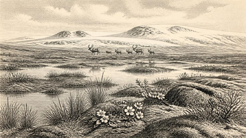
Around 31,404 BCE, Ireland was in Marine Isotope Stage 3, a cold, unstable phase before the Last Glacial Maximum, not a precisely datable historical year. Derryvree sediments in County Fermanagh record a freshwater, periglacial tundra mosaic between ice advances, with mosses, sedges, herbs and Arctic-alpine plants rather than woodland. Castlepook Cave, County Cork, preserves diverse fauna including reindeer, mammoth, giant deer, predators and smaller mammals, accumulated over long periods. A possibly cut-marked reindeer bone may indicate brief Upper Palaeolithic human activity, but proves neither settlement nor population. Lower sea levels facilitated regional movement, while advancing ice reshaped and destroyed landscapes.
Dateline
The label 31,404 BCE gives a deceptive impression of precision. No person in Ireland counted years in this manner, and the surviving evidence cannot isolate a single calendar year so far into the past. This was the later part of Marine Isotope Stage 3, within the last glacial cycle and long before the coldest, most extensive phase of the last British–Irish Ice Sheet. The responsible historical setting is therefore a broad calibrated interval, not an event assigned to one year.
In radiocarbon terms, 31,404 BCE lies about 33,354 years before AD 1950, the conventional ‘present’ used in dating. Radiocarbon measurements must then be calibrated because atmospheric carbon levels varied through time. At this age, calibrated ranges commonly extend across centuries or millennia. Ireland around this notional date can be illuminated by sediments, pollen, plant remains, insects, animal bones, cave deposits and glacial landforms. They reveal a cold, changing landscape and its fauna; they do not yield a political history, named communities or a continuous human story.
A Cold Interval, Not a Single Year
The closest Irish environmental archive is at Derryvree, near Maguiresbridge in County Fermanagh. Roadworks in 1969 cut through a drumlin and exposed organic-rich freshwater silts and fine sands between two separate layers of till, sediment deposited by ice. The deposit therefore preserves an interval between episodes of glaciation. Its conventional radiocarbon determination, 30,500 ± 1,170/1,030 radiocarbon years BP, calibrates only broadly, to roughly the middle of the fourth millennium before the present’s 30,000-year threshold: approximately the range in which 31,404 BCE falls.
This qualification matters. Derryvree does not prove that every part of Ireland was ice-free at the same moment, still less that its wetland existed unchanged in 31,404 BCE. It does demonstrate that, during this portion of the Middle Midlandian—an Irish regional term for part of the last glacial period—a freshwater and periglacial environment survived in south Fermanagh. The two tills above and below its organic layer are an especially forceful reminder that the landscape was not static. Ice had advanced before the wetland formed and would advance again.
Across the wider island, recent reconstructions indicate growth of the British–Irish Ice Sheet from about 31,000 years BP towards its maximum volume around 23,000 years BP. Translating that large-scale reconstruction into local conditions requires caution. Ice-sheet models, offshore sediment records and landforms do not supply a detailed weather map for each Irish valley. But they support the central picture: Ireland was entering a period in which cold, snow accumulation and glacier expansion would increasingly transform or erase earlier landscapes.
Water, Frost and Open Ground
Derryvree’s fossil assemblage offers the most tangible view of the ground itself. Mosses, plant macrofossils, pollen and insects indicate open tundra-like vegetation and a periglacial climate. The word ‘tundra’ should not conjure a featureless white waste. The evidence points instead to a treeless mosaic: shallow freshwater, wet mossy ground, sedge-rich margins, herbs and patches of sparse dry-land vegetation. Summer meltwater could collect in pools and channels even where winters were bitter, the ground seasonally frozen and growing seasons short.
Among the significant plant remains are species now associated with northern, alpine or Arctic-alpine settings, including mountain avens, bogbean, willow and specialised mosses. Their presence helps reconstruct environmental tolerances, not a complete planting list. Pollen is often damaged, rare tree pollen can travel long distances, and fossil deposits combine material gathered over time. Yet the overall pattern is clear enough: there was no closed woodland comparable to later prehistoric or modern Irish woodland. Wind-exposed ground, damp hollows and low vegetation dominated the local scene.
The environment had practical consequences for every animal able to use it. Exposure to wind, seasonal scarcity, frozen soils and fluctuating watercourses would have shaped movement and feeding. Large herbivores required extensive grazing or browsing territories; predators and scavengers depended upon those herbivores, their carcasses and sheltered places such as caves. In this sense, the ‘economy’ securely recoverable for Ireland at this date is an ecological one: energy moved through cold-adapted plants, grazers, carnivores and decomposers, rather than through farms, markets or households.
Animals of the Cork Caves
Far to the south-west, Castlepook Cave near Doneraile in north County Cork preserves a striking but difficult record. Cave excavations, chiefly undertaken in the early twentieth century, recovered remains of reindeer, giant deer, brown bear, wolf, fox, hare, lemming, spotted hyaena, woolly mammoth and other animals. Improved radiocarbon dating has shown that several cave bones originally thought younger are substantially older, placing important parts of the fauna in Marine Isotope Stage 3. The Irish Quaternary Fauna Project concluded that a relatively wide range of mammals reached Ireland between at least about 45,000 and 20,000 years ago.
That list should not be treated as one harmonious herd walking through Cork in a single season. Cave collections often combine bones accumulated over long periods, and many were recovered before modern recording of layers, position and formation processes. Some remains were dragged in by carnivores, some may have entered through natural processes, and individual species could have appeared at different times. What Castlepook securely establishes is that ice-age Ireland was, at intervals, accessible to a much richer mammalian fauna than the later island would support.
Reindeer are particularly relevant to the broad horizon around 31,404 BCE. A reindeer femur from Castlepook has been reported as about 33,000 years old and bears a deep surface modification interpreted by zoologist Ruth Carden as consistent with a sharp stone tool used on fresh bone. If that interpretation and the association of mark and bone age are sustained, it would be evidence of human handling of a reindeer in Ireland during the Upper Palaeolithic, far earlier than the formerly accepted chronology.
The Limits of the Reindeer Evidence
The cautious wording is essential. A date on bone establishes when the animal lived, not automatically when a mark was made. Taphonomic study must distinguish cuts from damage caused by carnivores, breakage, sediment abrasion, chemical alteration or old excavation and handling. Nor is there a securely associated hearth, stone-tool assemblage, dwelling floor, burial, human bone or repeated occupation layer at Castlepook that can be dated to this period. Recent fieldwork has located surviving Pleistocene deposits in parts of the cave, but it has not transformed the old collection into proof of a settled community.
The most that can responsibly be said is both important and limited: a brief human incursion is possible, perhaps even likely if the modified femur proves anthropogenic. Such a visit might have involved a small mobile party processing a carcass, but even that is an interpretation rather than a recovered scene. It cannot reveal how many people were present, whether they had hunted or found the animal, where they came from, what language they used, or whether they returned. Above all, it cannot support the claim that there was a permanent population in Ireland in 31,404 BCE.
Subsequent glaciation makes the absence of camps difficult to interpret. Ice erosion, meltwater, changing river courses, peat growth, rising seas and the submergence of former coastal plains have all damaged or hidden ancient surfaces. Lack of evidence is therefore not proof that nobody ever entered the island. It is, however, decisive against writing an unwarranted story of villages, lineage groups or an established ‘first Irish’ society.
Routes Across a Different Geography
Sea level during glacial times was lower than today, but that fact must not be simplified into a confident land bridge from Ireland to Britain. The Irish Sea basin had a complex geography shaped by sea level, ice and changing shorelines. At particular times, exposed shelves, ice margins, sea ice or narrower water crossings may have affected the movement of animals and people; the exact routes available around this date remain uncertain. The arrival of mammals in Ireland shows that movement occurred across the broader region, not the mechanism by which every species crossed.
For a possible human party, the relevant comparison is with Upper Palaeolithic hunter-gatherers elsewhere in north-west Europe: people equipped with portable stone technology and accustomed to seasonal mobility in demanding climates. This is a useful regional context, not evidence that a particular cultural group occupied Ireland. No Irish lithic industry of this date has been recovered in a secure context, and there is no basis for assigning identity, art, ritual practice or social organisation to hypothetical visitors.
No Polities, but a Living Landscape
Political affairs, warfare, diplomacy, formal religion and learning cannot be recovered for Ireland at this date. There were no documented rulers, territories, institutions or written records, and the archaeological evidence does not identify a resident human population from which such themes could be inferred. It would be misleading to fill that silence with imagined tribal rivalries, shamanic ceremonies or trading networks.
Culture is visible instead in the strict archaeological sense of the material record: the sedimentary histories of wetlands and caves, and perhaps one worked bone. There is no demonstrated agriculture, animal husbandry, pottery, metalwork, monument building or exchange system. If people entered Ireland, their livelihood would have depended upon hunting, gathering and acute knowledge of weather, terrain and animal behaviour. But these are possibilities derived from comparable Upper Palaeolithic societies, not observations made directly in an Irish campsite.
What can be said with confidence is that this was not an empty stage awaiting history. Derryvree’s freshwater life and Castlepook’s fauna show a dynamic Irish environment before the Last Glacial Maximum: locally habitable for specialised plants and animals, intermittently connected to wider north-west European ecological networks, and vulnerable to renewed ice growth. Around 31,404 BCE, Ireland’s history is the history of that unstable living landscape. Human history may have touched it briefly, but the evidence has not yet shown that it endured there.
Primary Sources
- A Middle Midlandian Freshwater Series at Derryvree, Maguiresbridge, County Fermanagh, Northern Ireland
- Palaeoecology: Quaternary of Northern Ireland Field Guide
- Early Midlandian–Middle Midlandian, Pleistocene, Northern Ireland
- A Reconsideration of the Radiocarbon Dating of the Marine Isotope Stage 3 Fauna from Southern Ireland
- The Irish Quaternary Fauna Project
- Heritage Artefacts of County Cork
- 2022:564 – Castlepook Cave, Castlepook South, Cork
- Late Pleistocene Chronostratigraphy and Ice Sheet Limits, Southern Ireland
- Geomorphological and Seismostratigraphic Evidence for Multidirectional Polyphase Glaciation of the Northern Celtic Sea
- Growth and Retreat of the Last British–Irish Ice Sheet, 31,000 to 15,000 Years Ago: the BRITICE-CHRONO Reconstruction
- BRITICE-CHRONO Maps and GIS Data of the Last British-Irish Ice Sheet 31 to 15 ka
- Growth and Retreat of the Last British-Irish Ice Sheet, 31,000 to 15,000 Years Ago: the BRITICE-CHRONO Reconstruction
- Maximum Extent and Dynamic Behaviour of the Last British–Irish Ice Sheet West of Ireland
- Character of Advance and Retreat of the Southwest Sector of the British-Irish Ice Sheet During the Last Glaciation
- New Insights on the Fauna of Ireland’s Younger Dryas and Early Holocene from Alice & Gwendoline Cave
- First Evidence of a Late Upper Palaeolithic Human Presence in Ireland
- Ireland’s Palaeolithic Archaeology – Fleeting Footprints in a Frozen Land
- Atlas of the Irish Rural Landscape: Archaeology and Cultural Heritage
- The Geological Heritage of County Leitrim
- Dryas octopetala in Fermanagh