

Maguirebridge’s Tundra Ledger31388 BCE
Around 31,388 BCE, Ireland lay within the climatically unstable Late Pleistocene MIS 3, not a precisely datable historical year. At Derryvree, County Fermanagh, freshwater organic deposits between glacial tills record an ice-free interval of open, periglacial tundra, wet hollows and seasonal cold. Castlepook Cave, County Cork, preserves remains of mammoth, reindeer, giant deer, bears, hyaenas and other fauna, demonstrating a living but distinctive insular ecosystem. A marked reindeer bone may indicate human butchery around 33,000 years ago, but remains contested and cannot prove settlement. No evidence supports Irish polities, agriculture or established communities; environmental archives provide the principal record today.
Dateline
Modern calendar-year precision is not available for Ireland in 31,388 BCE. No community on the island recorded a year in this form, and neither radiocarbon dating nor glacial stratigraphy can identify an event within a single year so far back. The label corresponds to roughly 33,300 calendar years before AD 1950, within the Late Pleistocene and Marine Isotope Stage 3 (MIS 3), a climatically volatile portion of the last Ice Age. The responsible historical subject is therefore not an annual chronicle, but an interval: a cold, changing Ireland known through sediments, fossils and a very small, contested body of possible archaeological evidence.
A Date Within a Range
The most useful Irish evidence close to this notional date comes from Derryvree townland near Maguiresbridge, County Fermanagh. Roadworks in 1969 exposed a remarkable sequence through a drumlin. Beneath the landform’s surface lay one till, the unsorted debris deposited by glacier ice; above it lay another. Between them were freshwater silts, fine sands and organic deposits. This order matters. It shows that an earlier glacier had passed across the district, that a non-glacial interval then allowed water and organic matter to accumulate, and that a later advance buried the evidence beneath fresh ice-borne sediment.
The Derryvree organic material produced the radiocarbon determination BIRM-166, conventionally dated to 30,500 radiocarbon years BP, with a large uncertainty. A radiocarbon age is not identical to a calendar age: atmospheric carbon-14 has varied through time, so old measurements require calibration against internationally maintained curves. At this depth of time, both the uncertainty of the original assay and the structure of the calibration curve produce a broad range rather than a pinpoint. It is appropriate to place Derryvree generally in the later part of MIS 3, and to regard 31,388 BCE as a useful position within the wider environmental horizon it illuminates—not as the date of a particular pool, animal or human action.
Freshwater Between Glaciers
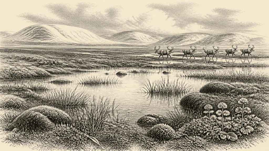
Derryvree provides unusually direct evidence for a locally ice-free landscape in northern Ireland during this broader interval. The deposits preserved pollen, plant macrofossils, mosses and invertebrate remains. Their combined signal is of open tundra vegetation and a periglacial climate: a country shaped by severe cold, freezing and thawing, sparse plant cover and wet hollows rather than by the wooded fields, peatlands and hedgerows familiar today. The old descriptive term “muskeg” captures something of the inferred terrain: mossy, sedge-rich and waterlogged ground, with shallow freshwater and muddy organic margins.
Some of the most evocative finds are small. Mosses and seeds testify to plants growing in or beside the water; pollen, though poorly preserved, is mainly from herbaceous vegetation. Such evidence supports an open landscape in which grasses, sedges and cold-adapted herbs were important. It does not justify reconstructing a uniform blanket of tundra across the whole island. Pollen can travel, deposits can be reworked, and one Fermanagh wetland was not all Ireland. Yet Derryvree is strong evidence that this part of the island contained exposed, cold ground and freshwater habitats between phases of glaciation.
Seasonality would have governed everyday ecological life. Summers could briefly activate pools, insects and plant growth; winters brought hard frost, prolonged snow cover and restricted forage. Permafrost or deeply seasonally frozen ground may have affected drainage and soil movement, though the deposits cannot supply a day-by-day weather record. The key point is contrast: Ireland was neither continuously entombed beneath ice nor a mild, forested refuge. It was a patchwork whose habitable spaces could expand or contract sharply as climate and glaciers changed.
The Wider Ice-Age Setting
MIS 3 was marked across the North Atlantic world by abrupt millennial-scale swings between relatively milder interstadials and colder stadials. Greenland ice-core records show the scale of such instability, but they cannot be translated mechanically into a local Fermanagh forecast. Irish deposits must retain priority for Ireland. They show that the island’s climate was harsh; wider climate records explain why that harshness could vary significantly over periods much shorter than a geological epoch but far longer than a human year.
At approximately 33,300 years ago, Ireland was approaching, but had not yet reached, the great expansion of the last British–Irish Ice Sheet. Recent reconstructions model sustained ice-sheet growth from about 31,000 years ago until its maximum volume around 23,000 years ago. This means that the named year belongs before the Last Glacial Maximum, not within its coldest and most extensive phase. Older Irish evidence also records earlier advances and retreats. The two tills enclosing Derryvree’s freshwater series make that local history tangible: ice had already transformed the landscape, and ice would do so again.
Lower global sea levels altered the outlines of the surrounding seas, but they did not turn the evidence into proof of a simple Irish land bridge or a settled migration route. Ireland occupied the north-western edge of Europe, with the Irish Sea basin and North Channel presenting changing barriers. Mammals evidently reached the island during favourable intervals, whether across temporary connections, ice, narrow water gaps or combinations of routes that remain debated. The movements of animals demonstrate ecological connectivity; they do not by themselves prove how, when or how often people travelled.
Castlepook’s Animal World
The clearest complementary archive lies far to the south at Castlepook Cave, near Doneraile in County Cork, also known as Mammoth Cave. Its limestone galleries yielded Ireland’s richest known assemblage of pre-Last Glacial Maximum vertebrate remains. The cave fauna includes woolly mammoth, giant deer, reindeer, brown bear and spotted hyaena, with wolf, Arctic fox and lemmings represented among cold-stage material. Radiocarbon dates on individual bones demonstrate that the cave accumulated remains over a long span, rather than preserving a single moment or one uncomplicated animal community.
That caution is essential. A cave is not a field census. Animals may have died naturally, fallen or wandered in, been transported by water, or been dragged inside by carnivores. Spotted hyaenas were especially important agents in creating bone accumulations. Earlier excavations at Castlepook also took place before modern standards of stratigraphic recording, while water disturbance and later intrusion complicated deposits. The assemblage nevertheless establishes an important fact: large herbivores and formidable predators inhabited, or repeatedly entered, Irish landscapes during the Middle and Late Midlandian glacial period.
For reindeer, mammoth and giant deer, open vegetation offered forage and movement corridors; for predators, concentrations of ungulates represented opportunity. The absence or rarity of species that are common in mainland north-west European assemblages is also informative. Ireland’s fauna was not simply a miniature copy of Britain or continental Europe. Its insular geography, shifting access routes, habitats and local extinctions shaped a distinctive and intermittently replenished animal world. The sparse record cannot determine herd sizes or seasonal migrations, but it rules out an empty landscape.
A Possible Human Trace
Castlepook has acquired particular importance because a reindeer femur from the cave has been reported as dating to about 33,000 years ago and bearing a deep linear mark interpreted by zooarchaeologist Ruth Carden as a stone-tool cut made during carcass processing. County Cork heritage material presents the specimen as possible evidence of Palaeolithic hunters in Ireland around 31,000 BC. If that interpretation is confirmed through full specialist publication and further finds, it would move the evidence for human activity on the island dramatically earlier than the securely recognised late-glacial traces from County Clare.
For now, however, the distinction between evidence and interpretation must remain plain. The bone is evidence for a reindeer and for a dated specimen in a complex cave archive. The mark may be evidence of butchery, but natural damage, carnivore action, excavation history and the relationship between marking and deposition all require rigorous taphonomic assessment. No securely associated stone-tool assemblage, hearth, dwelling surface, human bone, burial or artwork establishes a 32nd-millennium BCE settlement in Ireland. A marked bone, even if accepted, would show a human action on a carcass—not a village, a permanent population or an ethnic community.
No Polities, No Recorded Beliefs
Accordingly, political affairs, diplomacy and warfare cannot be reconstructed for Ireland at this date. There is no evidence for rulers, named groups, territorial institutions, law or organised conflict. Nor is there Irish evidence for agriculture, herding, pottery, metalworking, monuments, formal religious practice, long-distance trade or systems of learning. It would be misleading to import the celebrated cave art, elaborate tools and social traditions of Upper Palaeolithic mainland Europe directly into Ireland. They provide a broad comparative context for what mobile hunter-gatherers elsewhere could do; they do not prove equivalent activity on this island.
If people briefly reached Ireland, their economy would have depended on knowledge of terrain, weather and animals. Reindeer could provide meat, marrow, hides, sinew, antler and bone, but Castlepook cannot reveal which resources were taken from the individual represented by the femur, nor whether it was hunted, scavenged or encountered after death. A short seasonal visit, an exploratory crossing or no human presence at all remain materially different possibilities. The archaeological record is currently too thin to choose among them with confidence.
What This Year Can Mean
31,388 BCE is therefore best understood through Ireland’s fragile environmental archives. At Derryvree, freshwater mud, mosses, seeds, pollen and insects record a cold, open wetland lying between glacier advances. At Castlepook, bones record a broader Ice-Age fauna in which mammoth, reindeer, giant deer, bears and hyaenas formed part of Ireland’s ecological history. Together they reveal regional variation, mobility and climatic instability before the later ice sheet reached its full power. They do not reveal an Irish society in the conventional historical sense.
That absence is not a failure of the past; it is a fact about survival and evidence. Glaciers repeatedly eroded landscapes, rising seas later reshaped coastlines, and nineteenth- and early twentieth-century collecting removed much material without modern documentation. New excavations, direct dating, ancient-DNA work and reassessment of museum collections may yet alter the picture. Until then, the most compelling history of Ireland around this point is written not in annals but in a buried Fermanagh wetland and the bones of a Cork cave: evidence of a severe but living world at Europe’s Atlantic edge.
Primary Sources
- A Middle Midlandian Freshwater Series at Derryvree, Maguiresbridge, County Fermanagh, Northern Ireland
- Palaeoecology: The Middle Midlandian Palaeoenvironment of South Fermanagh
- Castlepook Cave: County Geological Site Report
- 2022:564 — Castlepook Cave, Castlepook South, Cork
- Areas of Scientific Interest in County Cork: Castlepook Caves
- Heritage Artefacts of County Cork 2021
- Pleistocene Vertebrates in the British Isles
- The Irish Quaternary Fauna Project
- Irish Pleistocene Biostratigraphy
- New Insights on the Fauna of Ireland's Younger Dryas and Early Holocene from Alice & Gwendoline Cave
- The Mesolithic in Ireland: When Was It?
- Growth and Retreat of the Last British–Irish Ice Sheet, 31,000 to 15,000 Years Ago: The BRITICE-CHRONO Reconstruction
- Character of Advance and Retreat of the Southwest Sector of the British-Irish Ice Sheet During the Last Glaciation
- Stratigraphic and Palaeo-Geomorphological Evidence for the Glacial-Deglacial History of the Last British-Irish Ice Sheet in the North-Western Irish Sea
- Using Novel Methods to Track British and Irish Ice Sheet Dynamics Since the Late Pleistocene, Along the West Porcupine Bank, NE Atlantic
- New Data for the Last Glacial Maximum in Great Britain and Ireland
- Dimensions and Chronology of the Last Ice Sheet in Western Ireland
- Composition and Consequences of the IntCal20 Radiocarbon Calibration Curve
- The IntCal20 Northern Hemisphere Radiocarbon Age Calibration Curve (0–55 cal kBP)
- The IntCal20 Approach to Radiocarbon Calibration Curve Construction
- Dansgaard–Oeschger Events in Climate Models: Review and Baseline Marine Isotope Stage 3 Protocol
- Marine Isotope Stage 3 Sea Level Fluctuations: Data Synthesis and New Outlook
- Ice Core Paleoclimatology
- Mid-to-Late Marine Isotope Stage 3 Mammal Faunas of Britain: A New Look