

Derryvree’s Open-Pool Tundra31269 BCE
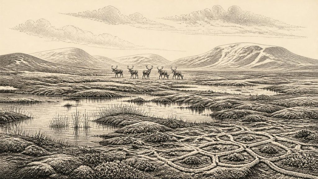
At 31,269 BCE, Ireland lay within the unstable Late Pleistocene MIS 3, not a calendar year. Derryvree, County Fermanagh, preserves freshwater silts between tills, showing cold, treeless periglacial wetlands and open pools during an ice-free interval before later glaciation. Ireland’s ice cover was regionally variable; maximum expansion followed later. Cave deposits and landforms reveal climates, sea levels and possible animal routes. Castlepook Cave, County Cork, yielded reindeer, hyena, mammoth and cold-adapted fauna. A marked reindeer bone may record human butchery around 33,000 years ago, but no settlement evidence exists. The period represents a volatile, intermittently habitable landscape, not a society.
Dateline
The label 31,269 BCE is useful for ordering a long chronology, but it cannot identify a recoverable year in Irish prehistory. No one in Ireland counted time by this calendar, and neither radiocarbon dating, cave deposits nor glacial sediments can isolate a single season, household or event so far back. In the conventional archaeological scale of years before AD 1950, the label falls at roughly 33,200 years ago. It belongs to the Late Pleistocene, within Marine Isotope Stage 3 (MIS 3): an unstable part of the last Ice Age, before the fullest expansion of the last British–Irish Ice Sheet.
The responsible history for this point is therefore not one of named rulers, settlements or battles. It is a history assembled from unusually fragile traces: freshwater silts sealed beneath ice-laid deposits in County Fermanagh; cave bones from north County Cork; calcite laid down in a Kerry cave when liquid water could percolate underground; and the wider pattern of glacial landforms on land and beneath the surrounding seas. These sources illuminate a changing Irish environment and the possibility, rather than the demonstrated permanence, of human presence.
Calendar Labels and Deep Time
The closest Irish chronological anchor is the Derryvree deposit near Maguiresbridge, County Fermanagh. Its organic sediments produced a radiocarbon result of 30,500 +1,170/−1,030 radiocarbon years BP, conventionally known as Birm-166. When calibrated, this has been published as a broad range of about 36,900–31,700 calibrated years BP. The modern label 31,269 BCE lies within that span, but this is not evidence that every layer at Derryvree, let alone every part of Ireland, dates precisely to that named year. The deposit records an interval whose duration and internal changes cannot be resolved to calendar-year precision.
That distinction matters. A radiocarbon measurement dates organic material, subject to statistical uncertainty and the complexities of calibration; it does not date a map of Ireland or a moment in human history. The Derryvree range has been related broadly to several Greenland interstadials, short-lived warmer episodes registered in ice cores, but it should not be treated as an exact synchronisation with one particular climatic pulse. Around the notional date, Ireland may have contained both locally ice-free ground and expanding ice in different regions or at different moments. The evidence is strong enough to reject a simple image of an island uniformly entombed beneath ice, but not to draw a precise coastline or ice margin for 31,269 BCE.
A Wetland Beneath a Drumlin
Derryvree is important because road excavations in 1969 cut through a drumlin and revealed fine sands and organic freshwater silts trapped between two thick tills. Till is sediment deposited directly by glacier ice. The lower till shows that ice had previously occupied the site; the intervening freshwater sediments show that ice did not cover that locality while they accumulated; and the upper till demonstrates a later return or expansion of ice. This is a stratigraphic sequence of successive environmental regimes, not a village floor or a human campsite.
Its biological contents nevertheless permit a vivid, disciplined reconstruction. Pollen, plant macrofossils, mosses and insect remains indicate open tundra vegetation and a periglacial climate. “Periglacial” does not mean the ground lay underneath a glacier. It denotes a severe cold environment shaped by repeated freezing and thawing, sparse or low vegetation, seasonal water and frost action, near the margins of ice. The insect evidence has been interpreted as pointing to muskeg-like wet ground: shallow open pools rich in plant matter, bordered by mosses and sedges. Derryvree was therefore neither a modern Irish bog nor an empty white wilderness. It was a cold, treeless wetland mosaic, with standing water in sheltered hollows and exposed ground beyond them.
This landscape placed strong limits on life. Long winters, short growing seasons and frozen or waterlogged ground constrained plants and animals alike. Yet the very existence of freshwater sediments and their fossil biota shows that the locality supported more than bare rock and ice. Plant communities could occupy wet margins and disturbed mineral soils. Such habitats supplied grazing, browse, cover and water in a landscape that would have changed rapidly with temperature, snow cover and the proximity of ice.
Ice, Water and Uneven Ireland
Later glaciation has greatly complicated the record. The drumlins, tills, streamlined bedrock and moraines familiar in Ireland are products of moving ice, but their prominent survival does not make them a simple map of one phase. They register advances, changes in flow and retreat across many millennia. Modern reconstructions indicate that the main growth to the extensive Last Glacial Maximum configuration came after the period represented by Derryvree. In broad terms, evidence suggests that much of Ireland was ice-free until about 34,000 years ago, while the ice sheet expanded over a long, regionally uneven interval and reached offshore limits later, around 27,000–23,000 years ago in different sectors.
Thus, 31,269 BCE belongs to an interval of mounting instability rather than the later maximum of continuous, island-wide ice cover. Organic material below till at Greenagho, also in County Fermanagh, provides another indication of ice-free conditions in north-central Ireland earlier in MIS 3. In south-west Ireland, episodes of speleothem growth at Crag Cave demonstrate that, at intervals during MIS 3, liquid water entered cave systems and temperatures were sufficiently ameliorated for calcite to form. These records do not show a mild climate, nor do they prove that all regions experienced the same conditions at once. They demonstrate variation: a crucial fact in an island whose topography, exposure to the Atlantic, proximity to ice and changing sea levels all mattered.
Lower sea levels altered the geography around Ireland, but it is unwise to imagine a permanent, straightforward land bridge. Ice, sea, rivers, exposed shelves and coastal lowlands changed through time. The movement of mammals from Britain to Ireland is evidence that routes existed during parts of the wider period, yet no surviving route can be assigned to this particular calendar label. Much potential evidence from low-lying coasts and shelves now lies submerged, was later eroded, or was overridden by ice.
Castlepook’s Animal World
In County Cork, Castlepook Cave, also called Mammoth Cave, offers a complementary archive. Excavated principally in the early twentieth century, it yielded Ireland’s most important collection of mammal remains from the last cold stage. The National Museum of Ireland preserves, among other material, a spotted hyena skull from the cave, donated through the Royal Irish Academy’s cave-exploration work. Associated dating and environmental interpretation place hyenas and other mammals moving from Britain into Ireland broadly between about 45,000 and 30,000 years ago.
The cave assemblage shows that a cold-adapted large-animal community ranged through at least parts of Ireland before the coming glacial maximum. Reindeer are especially significant; other finds and recent investigations indicate a fauna including hyaena, brown bear, fox, hare, lemmings and mammoth remains. A cave collection is not a census of a single moment. Bones may have accumulated through natural death, carnivore activity, scavenging, water movement and excavation disturbance, and individual specimens need not all be contemporary. Still, the assemblage decisively widens the environmental picture supplied by Derryvree: Ireland could sustain, or be traversed by, sizeable mammals and formidable predators in a cold open landscape.
The Human Question
One reindeer femur from Castlepook has made this period exceptionally important for Irish archaeology. Modern accelerator radiocarbon dating has placed the bone at roughly 33,000 years ago, close to the broad period under discussion. A deep linear modification has been interpreted as a cut or chop made by a sharp stone tool while the bone was fresh. If that interpretation is confirmed, it would indicate that Upper Palaeolithic people processed a reindeer in Ireland long before the better-attested post-glacial settlement of the island.
It must remain a conditional conclusion. The bone is not accompanied by a securely stratified stone-tool assemblage, hearth, dwelling, human skeleton, burial or repeated occupation surface. Recent excavation at Castlepook has located surviving deposits and additional faunal material, but reported no cultural artefacts in the 2022 fieldwork. The mark is therefore intriguing evidence of possible butchery, not proof of a resident population, a named group or a continuous Irish Palaeolithic tradition. It is equally unsafe to turn one modified bone into a story of a hunting party on a particular day in 31,269 BCE.
What Cannot Yet Be Claimed
There is no evidence for political institutions, chiefs, territorial boundaries, diplomacy or warfare in Ireland at this date. Nor is there evidence for farming, herding, metalworking, long-distance trade in finished goods, formal religious monuments, art, writing or learning institutions. The absence is not proof that no people ever crossed the landscape; it reflects the extraordinary difficulty of preserving and finding traces in a terrain later transformed by ice and sea-level change. But historical restraint requires that absence to be acknowledged.
If people did reach Ireland in this wider interval, their lifeways were likely to have been highly mobile and dependent on knowledge of animals, weather, water, stone and seasonal terrain. That is an inference from Upper Palaeolithic lifeways elsewhere in north-west Europe, not direct evidence from an Irish camp. It cannot tell us what language was spoken, how people organised kinship, whether they returned repeatedly, or what beliefs accompanied the handling of a reindeer carcass. The evidence supports a possible brief human act, not a recovered society.
The most important development around this notional year was environmental: Ireland stood in a volatile pre-maximum Ice Age world. At Derryvree, cold open wetlands and pools existed between episodes of glaciation. At Castlepook, animals including reindeer and spotted hyaena left bones in a limestone cave, while one reindeer bone poses a still-unsettled question about human action. Those fragments are slight, but they transform the subject. Rather than a blank before later settlement, Ireland at this depth of time was a changing northern landscape, intermittently habitable for plants and animals, and perhaps briefly visited by people whose wider story has not survived.
Primary Sources
- A Middle Midlandian Freshwater Series at Derryvree, Maguiresbridge, County Fermanagh, Northern Ireland
- A Middle Midlandian Freshwater Series at Derryvree, Maguiresbridge, County Fermanagh, Northern Ireland
- Middle Midlandian Interstadial Deposits at Greenagho, Near Belcoo, County Fermanagh, Northern Ireland
- Trimlines, Blockfields and the Vertical Extent of the Last Ice Sheet in Southern Ireland
- The Last Irish Ice Sheet: Extent and Chronology
- Growth and Retreat of the Last British–Irish Ice Sheet, 31,000 to 15,000 Years Ago: The BRITICE-CHRONO Reconstruction
- Exploring Controls of the Early and Stepped Deglaciation on the Western Margin of the British Irish Ice Sheet
- BRITICE Glacial Map, Version 2: A Map and GIS Database of Glacial Landforms of the Last British–Irish Ice Sheet
- Episodic Speleothem Deposition Tracks the Terrestrial Impact of Millennial-Scale Last Glacial Climate Variability in SW Ireland
- Last Glacial Maximum Cirque Glaciation in Ireland and Implications for Reconstructions of the Irish Ice Sheet
- Maximum Extent and Dynamic Behaviour of the Last British–Irish Ice Sheet West of Ireland
- The Colonization of Ireland: A Human Ecology Perspective
- Ireland: Submerged Prehistoric Sites and Landscapes
- Figure 6: The Subdivision of the Quaternary Period in Ireland
- References and Recommended Reading
- Spotted Hyena Skull
- Heritage Artefacts of County Cork
- 2022:564 – Castlepook Cave, Castlepook South, Cork
- Mammoth Cave
- Palaeolithic Ireland – New Evidence Emerges from the Emerald Isle
- Ireland’s Palaeolithic Archaeology – Fleeting Footprints in a Frozen Land
- Autumn 2023 Newsletter
- Episodic Speleothem Deposition Tracks the Terrestrial Impact of Millennial-Scale Last Glacial Climate Variability in SW Ireland
- BRITICE Glacial Map, Version 2: A Map and GIS Database of Glacial Landforms of the Last British-Irish Ice Sheet






