

Derryvree’s Two-Till Archive31255 BCE
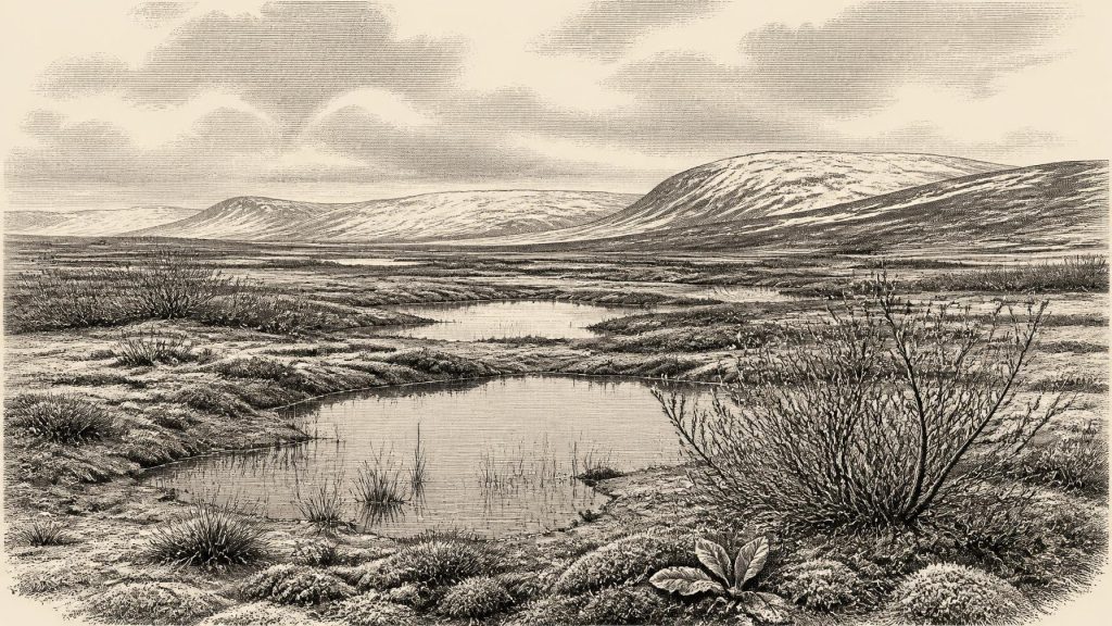
31,255 BCE is a chronological label, not a datable event. Derryvree, County Fermanagh, preserves freshwater sediments between two glacial tills, radiocarbon-dated broadly to a period encompassing this date. Its pollen, plants, mosses and insects indicate cold, treeless tundra wetlands with pools, seasonal productivity and severe periglacial conditions. Castlepook Cave in County Cork records MIS 3 fauna including mammoth, reindeer, giant deer, hyena and Arctic species, although its deposits are mixed. A marked reindeer bone may signal early human butchery, but cannot prove settlement. Ireland’s history here is reconstructed from fragmentary environmental evidence amid changing ice, uncertain routes and no polities.
Dateline
The label 31,255 BCE is a modern way of locating a point in deep time, not a year that can be recovered from an Irish chronicle. No known community in Ireland counted years in this fashion, and archaeology cannot assign an event, ruler, journey or settlement to this precise calendar year. The most responsible subject is instead a broad Late Pleistocene interval, within Marine Isotope Stage 3 (MIS 3) and the Irish Midlandian glacial episode. Its evidence is sparse, local and often difficult to date, but it is sufficient to overturn any image of a uniformly lifeless Ireland buried continuously beneath ice.
The closest chronological anchor is the Derryvree deposit near Maguiresbridge, County Fermanagh. Organic mud from this site produced the legacy radiocarbon determination BIRM-166, 30,500 ± 1,100 radiocarbon years before present. Radiocarbon years are not calendar years: changing atmospheric carbon-14 levels mean that measurements must be calibrated. Published calibration places the deposit very broadly at about 36,900–31,700 calibrated years before present, approximately 34,950–29,750 BCE. Thus 31,255 BCE falls within the range associated with the deposit, but it cannot be isolated within it. The date identifies neither the beginning nor the end of the Derryvree environment, much less a particular day in its history.
A Wetland Between Ice Advances
Derryvree was revealed during road works in February and March 1969, when a cutting passed obliquely through a drumlin about two kilometres north-east of Maguiresbridge. Beneath the modern land surface lay two substantial tills: unsorted sediment deposited directly by moving glacier ice. Between them was a freshwater series of fine sands, silts and organic mud. This arrangement supplies the firmest conclusion available. Ice had affected the locality before the freshwater sediments accumulated; the site then experienced an interval in which standing or slow-moving water, plants and animals were present; and ice later returned or expanded across it, sealing the deposit below another till.
That sequence does not prove that all Ireland was ice-free at once. A drumlin cutting is a local archive, while ice sheets are large and uneven systems with shifting margins, outlets and upland centres. Nor do the deposits establish a stable, mild interlude. They record a cold, periglacial landscape: one close to glacial conditions and heavily shaped by frost, seasonal thaw and unstable drainage, but not necessarily covered by glacier ice while the freshwater layers formed. Later ice movement eroded or buried enormous areas of older terrain, helping to explain why this small Fermanagh exposure matters so much.
Modern reconstructions of the British–Irish Ice Sheet reinforce the need for caution. The major Last Glacial Maximum lay later, broadly between about 27,000 and 23,000 calibrated years ago for the final maximum advance of the Irish Ice Sheet. Around the period represented by Derryvree, ice was growing and climate was variable rather than frozen into one unchanging configuration. The island was part of a north-west European zone in which the extent of ice, snow cover, rivers and habitable ground could alter substantially over centuries and millennia. Those timescales are the appropriate measure for this article, not a single year.
Bogbean and Open Pools
Derryvree’s organic sediments preserve a remarkable biological record. Poorly preserved pollen, plant macrofossils, mosses and insects point towards open tundra vegetation, not forest. Grasses, sedges, herbs, juniper and low-growing cold-adapted plants occurred in or near the locality. The few grains of pine and hazel pollen do not demonstrate a nearby woodland; they may have travelled long distances or been redeposited from older sediments. The more consistent message of the assemblage is treeless, exposed ground with wet hollows.
Several fossils give this landscape texture. Bogbean (Menyanthes trifoliata) and alternate water-milfoil (Myriophyllum alterniflorum) attest to freshwater habitats. Dwarf willow (Salix herbacea) and mountain avens (Dryas octopetala) are plants associated with cold, open country. Mosses and insects have been interpreted as evidence for muskeg-like ground: waterlogged, plant-rich terrain, with shallow pools and mossy margins. “Muskeg” should not suggest a familiar modern raised bog. This was a patchwork of mineral sediment, organic mud, sedges, low vegetation and water, exposed to a far more severe climate than today’s Fermanagh.
Everyday life in this environment was seasonal and ecological rather than humanly documented. Short warmer seasons permitted plants to grow, insects to breed and freshwater organisms to occupy pools. Winter brought prolonged cold, frozen ground and snow, while repeated freezing and thawing broke up soils and moved sediment. Such processes produced demanding terrain, but the freshwater deposits themselves demonstrate that the locality was not an empty expanse of permanent ice. The productive margins of pools and wet ground would have concentrated forage and water for animals moving through the wider landscape.
The Southern Cave Fauna
At Castlepook Cave, also called Mammoth Cave, near Doneraile in north Cork, excavations between 1904 and 1908 recovered a far richer but more complicated assemblage. The National Museum of Ireland holds material from the cave, including spotted hyena remains. Castlepook has yielded bones of woolly mammoth, reindeer, giant deer, brown bear, wolf, Arctic fox, mountain hare, stoat and lemmings, as well as the hyena. Taken together, these animals show that at intervals during MIS 3 Ireland supported, or was visited by, communities characteristic of cold northern European environments.
The cave does not provide a neat census for 31,255 BCE. Its deposits were excavated long before modern standards of recording, different layers were disturbed or mixed, and the bones did not all enter the cave at the same time. Improved radiocarbon pretreatment has also shown that some older Irish cave determinations were misleading. Re-dating has confirmed that important Castlepook material belongs to MIS 3, while also demonstrating why individual finds must not be casually treated as one contemporaneous animal herd or one episode of occupation. The fauna is secure evidence for a broader Ice Age world; its exact internal chronology remains a subject for careful reconstruction.
Spotted hyena is especially evocative but should not be romanticised. Hyenas may have used caves as dens, dragging in carcass parts or leaving bones through scavenging and feeding. Tooth marks, breakage and the distribution of remains can therefore record carnivore behaviour as much as the deaths of prey animals in the surrounding country. Mammoths and giant deer indicate large herbivores, reindeer imply cold-season grazing landscapes, while foxes, wolves and lemmings reveal several ecological niches. Yet absence from the fossil list is not proof of absence from Ireland: preservation, cave access, collecting history and later glacial destruction all shape what survives.
A Possible Human Signal
One Castlepook reindeer femur has drawn particular attention because it bears a deep linear modification interpreted by Ruth Carden as a cut or chopping mark made with a sharp stone implement while the bone was fresh. The bone has been associated with an age of roughly 33,000 radiocarbon years before present. If the mark is genuinely anthropogenic and contemporary with the animal, it may indicate that people butchered a reindeer in Ireland during the earlier part of the Late Pleistocene. That would be of exceptional importance, placing a human visit many millennia before Ireland’s securely dated terminal-Pleistocene butchered bear bone from Alice and Gwendoline Cave, County Clare.
It is not, however, proof of a settled population, a camp or a named Palaeolithic culture in Ireland at this date. No securely associated stone-tool assemblage, hearth, dwelling or human remains have been recovered from Castlepook’s old mixed deposits. A surface groove also requires taphonomic assessment against other possible forms of damage, including carnivore activity, sediment abrasion, trampling, excavation damage and later breakage. The responsible conclusion is that the femur is a serious and potentially very early proxy for human activity, not a foundation for claims about an Irish tribe, permanent settlement or a specific hunt in 31,255 BCE.
No Polities, No Trade Routes
Political affairs, diplomacy, formal religion and literacy leave no identifiable evidence in Ireland for this interval. There were no states, kingdoms, borders or institutions whose actions can be narrated. Nor is there evidence for trade in the later sense: no exchanged objects, imported materials or maintained routes can be tied to this date. If people did reach Ireland, they would have belonged to small, highly mobile hunter-gatherer groups within the wider Upper Palaeolithic world of north-west Europe. Their social organisation, beliefs, language and movements remain unknown in the Irish record.
Connection with Britain and the exposed landscapes now beneath the Irish Sea is nevertheless central to interpretation. Sea level was much lower than today, and animal populations plainly reached Ireland at some point during the Late Pleistocene. Exactly how they crossed is unresolved. Researchers have long questioned the existence of a simple, durable dry land bridge across the Irish Sea; ice, shallow seas, changing coastlines and possible short-lived routes all complicate the picture. It is safest to say that Ireland was not ecologically isolated in the modern sense, while avoiding a map that turns uncertain crossings into a certain highway.
The lasting development around this notional year was therefore environmental. In Fermanagh, freshwater life accumulated between episodes of glaciation; in Cork, caves preserved traces of an Ice Age fauna whose chronology is still being refined. These scattered archives describe a changing land of tundra, wetlands, large mammals and severe climate. They also mark the limits of knowledge. Ireland’s history at 31,255 BCE is not an annual narrative, but a disciplined reconstruction from mud, pollen, insects, bones, ice and uncertainty.
Primary Sources
- A Middle Midlandian Freshwater Series at Derryvree, Maguiresbridge, County Fermanagh, Northern Ireland
- The Irish Quaternary Fauna Project
- A Reconsideration of the Radiocarbon Dating of the Marine Isotope Stage 3 Fauna from Southern Ireland
- First Evidence of a Late Upper Palaeolithic Human Presence in Ireland
- New Insights on the Fauna of Ireland’s Younger Dryas and Early Holocene from Alice & Gwendoline Cave
- Spotted Hyena Skull
- Exploring Controls of the Early and Stepped Deglaciation on the Western Margin of the British Irish Ice Sheet
- Growth and Retreat of the Last British–Irish Ice Sheet, 31,000 to 15,000 Years Ago: the BRITICE-CHRONO Reconstruction
- The Timing and Magnitude of the British–Irish Ice Sheet Between Marine Isotope Stages 5d and 2
- Last Glacial Maximum Cirque Glaciation in Ireland and Implications for Reconstructions of the Irish Ice Sheet
- Sedimentology and Chronology of the Advance and Retreat of the Last British-Irish Ice Sheet on the Continental Shelf West of Ireland
- Cosmogenic 10Be Chronology of the Last Deglaciation of Western Ireland, and Implications for Sensitivity of the Irish Ice Sheet to Climate Change
- Early Midlandian–Middle Midlandian, Pleistocene, Northern Ireland
- Palaeoecology: The Middle Midlandian Palaeoenvironment of South Fermanagh
- Menyanthes trifoliata
- Myriophyllum alterniflorum
- Salix herbacea
- Dryas octopetala
- The IntCal20 Northern Hemisphere Radiocarbon Age Calibration Curve (0–55 cal kBP)
- Episodic Speleothem Deposition Tracks the Terrestrial Impact of Millennial-Scale Last Glacial Climate Variability in SW Ireland
- The Problem of a Late Quaternary Landbridge Between Britain and Ireland
- Origin of British and Irish Mammals: Disparate Post-Glacial Colonisation and Species Introductions
- Archaeology Research Excavation Grant 2022: Final Report
- Heritage Artefacts of County Cork