BIRM-166 Between Glaciers30969 BCE
30,969 BCE denotes a broad late Marine Isotope Stage 3 horizon, not a datable Irish event. At Derryvree, County Fermanagh, organic freshwater sediments between glacial tills, dated by BIRM-166, show an ice-free interval supporting treeless wetlands, mosses, sedges, herbs, insects and herbivores amid seasonal cold. Ireland was affected by fluctuating ice rather than continuously ice-covered, before the Last Glacial Maximum. Castlepook Cave, County Cork, preserves MIS 3 fauna including reindeer, giant deer and predators. A marked reindeer bone may indicate human butchery, but insecure context prevents firm conclusions. Evidence reveals a harsh, dynamic landscape, not permanent settlement or social organisation.

Dateline
The label 30,969 BCE is a modern way of placing an extraordinarily remote point in time on a familiar calendar. It corresponds approximately to 32,918 years before AD 1950, the reference year used in archaeological “before present” dating. It cannot, however, identify an Irish event in a particular year. No written calendar, settlement sequence or securely dated human occupation in Ireland has the resolution to do that. The responsible history of this moment is therefore an account of a period: the later part of Marine Isotope Stage 3, within the last Ice Age, reconstructed from buried sediments, plant and insect remains, animal bones, cave deposits and the larger history of the British–Irish Ice Sheet.
Dating a Calendarless Landscape
Calendar conversion can give a false impression of precision. Radiocarbon determinations measure the decay of carbon-14 and must be calibrated against independently dated records because atmospheric carbon-14 levels have changed through time. For ages this old, calibrated results can span centuries or millennia and may form more than one probability range. The notional year 30,969 BCE should thus be read as a point within a broad chronological horizon, not as the date of a hunt, migration or climatic turning point.
Ireland’s best evidence for this horizon is not a village or a grave but the Derryvree organic deposit near Maguiresbridge in County Fermanagh. Exposed in a road cutting, fine freshwater sediments and organic material lay between two tills: unsorted debris deposited by glacier ice. Their position establishes the essential sequence. Ice had crossed the locality; an ice-free interval then allowed water, mud, plants and animals to accumulate; later ice advanced over the ground and sealed the deposit below a further till. A conventional radiocarbon measurement from the deposit, BIRM-166, was 30,500 ± 1,100 radiocarbon years BP. Its calibrated implications are necessarily broad, but the date places the deposit within the unstable MIS 3 world relevant to this calendar label.
The surrounding North Atlantic climate was not steady. Greenland ice-core records show abrupt alternations between colder stadials and shorter, milder interstadials. Around 32.9 thousand calendar years ago, the wider region was in a cold phase following the brief Greenland Interstadial 5. That does not provide a thermometer reading for Fermanagh on one day or one year. It does, though, help explain why Irish environmental records preserve rapid shifts between ice activity, exposed ground, wetlands and renewed glaciation rather than a simple march from warm to cold.
A Wetland Under the Drumlins
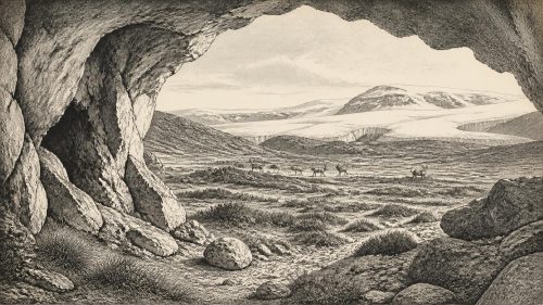
Derryvree offers the clearest local picture. Fossil pollen, plant macrofossils and insects point to open, treeless terrain rather than woodland. Sedges, grasses, herbs, juniper and an abundant moss flora grew around shallow freshwater. Finds including bogbean, water-milfoil, mountain-avens and lesser clubmoss indicate wet ground and pools within a cold, exposed setting. The older term “muskeg” is useful if used cautiously: not a modern blanket bog transplanted into the past, but a mosaic of saturated organic ground, sedge margins, shallow water and low vegetation in a periglacial landscape.
This was an environment of strong seasonality. Winter frost and repeated freezing and thawing would have disturbed soils and restricted tree growth. During the growing season, however, waterlogged hollows and stream margins could be highly productive. Mosses, sedges and flowering plants supported insects and provided fodder for herbivores. The evidence does not allow a reconstruction of a continuous lake, a single shoreline or a particular year’s weather. It supports something more durable: northern Ireland was not uniformly buried beneath ice while the Derryvree sediments formed. There were intervals in which living freshwater habitats existed between glacial episodes.
That conclusion matters because the familiar image of Ice-Age Ireland as a permanently blank white sheet is misleading for MIS 3. Ice was an active force in the landscape, but its margins and extent changed. The full Last Glacial Maximum came later. Reconstructions of the British–Irish Ice Sheet place its major maximum development broadly after this period, with important sector-by-sector variation; the Irish Sea Ice Stream reached a far southern extent around 27,000 years ago, while maximum global ice volume occurred later still. At 30,969 BCE, Ireland stood within an approaching glacial crisis, not at its final maximum.
Caves and Cold-Adapted Fauna
In southern Ireland, Castlepook Cave near Doneraile, County Cork, supplies another kind of evidence. Old cave excavations recovered a rich but complicated collection of bones. Improved radiocarbon pretreatment has shown that several Castlepook specimens are far older than earlier results suggested, by roughly 5,000 to 12,000 radiocarbon years in the re-dating programme. The revision confirms that elements of the assemblage belong to MIS 3, well before the Last Glacial Maximum.
Reindeer are central to the Castlepook story. Their presence fits an open, cold landscape in which mobile grazers could exploit seasonal forage. Other southern Irish cave evidence includes large mammals and predators, notably giant deer and spotted hyaena, though it is essential not to compress every bone in a cave collection into one simultaneous community. Cave deposits may accumulate over long periods; carnivores can transport carcass parts; water and sediment can move bones; and nineteenth- and early twentieth-century excavation methods rarely recorded contexts to modern standards. A cave fauna is evidence for animals in a region across a span of time, not a census taken in one season.
Even so, the combination is revealing. Reindeer, giant deer, carnivores and small cold-adapted species point to habitats unlike later forested Ireland: more open country, shorter growing seasons and large ranges in which animals could move between patches of food and shelter. Stable-isotope research on later Irish giant deer suggests seasonal movement between landscapes, a useful reminder that animals were not fixed inhabitants of a single valley. It cannot demonstrate the route of a particular MIS 3 herd, but it makes mobility a sensible ecological expectation.
The Castlepook Human Question
A reindeer femur from Castlepook has given this period exceptional archaeological interest. It has been publicly interpreted by zooarchaeologist Ruth Carden as bearing a deep fresh-bone mark made by a sharp stone implement during butchery; the specimen has been presented as about 33,000 years old. If the mark is anthropogenic, it would be evidence that a person processed a reindeer in Ireland during the Upper Palaeolithic, vastly earlier than the island’s better-established terminal-Pleistocene evidence.
But it must remain a carefully qualified possibility, not the foundation for an invented population. A radiocarbon result dates the animal bone, not necessarily the moment when a surface mark was made. The bone was recovered from an old cave collection, without a securely associated stone-tool assemblage, hearth, dwelling floor, human remains or repeated occupation deposit of comparable age. Carnivore damage, trampling, sediment movement, weathering and excavation damage must all be excluded when marks on bone are assessed. Renewed excavation at Castlepook is valuable precisely because it can test the older collection against intact sediments and modern methods.
Accordingly, no named hunting band, camp, leader or route across Ireland can responsibly be placed in 30,969 BCE. If people did visit, the most that can presently be proposed is a brief and probably mobile Upper Palaeolithic presence linked to the animal resources of north-west Europe. Whether Ireland was reached across exposed coastal lowlands, ice, water or a shifting combination of these remains a question of palaeogeography, not an established narrative of migration. Lower sea levels changed the map, but the existence, timing and usefulness of land connections between Ireland and Britain remain debated.
Society Beyond Recovery
There is no evidence from this date for political institutions, diplomacy, territorial rule, organised warfare, formal religion, art, language, farming, trade networks or permanent Irish settlement. Their absence from the record is not proof that every form of social relationship was absent if people briefly entered the island; it is a limit on what the evidence can bear. A single possible butchered bone cannot reveal kinship, belief, exchange or authority. Nor should the later Mesolithic, Neolithic or early medieval past be projected backwards into this very different world.
The demonstrable “economy” was ecological rather than social: plants converting a short season’s light into forage; grazing animals moving through open ground; predators and scavengers using carcasses and caves; freshwater pools sustaining specialised wetland life. The principal conflict was environmental. Ice, frost, changing drainage and shifting vegetation repeatedly remade the opportunities available to every organism. Such changes also help explain the scarcity of evidence: later glacial erosion, sediment disturbance, rising seas and antiquarian excavation have all reduced the chance that fragile campsites survived.
For Ireland around this notional year, then, BIRM-166 is more informative than any imagined human story. The Fermanagh deposit records water, plants and organic life sheltered between advances of ice. Castlepook records a wider cold-country fauna and a tantalising, unconfirmed prospect of human butchery. Together they show an Ireland that was harsh but not empty: a changing northern landscape whose history must be read in silt, pollen, bone and ice, with uncertainty acknowledged as part of the evidence rather than a gap to be filled by invention.
Primary Sources
- A Reconsideration of the Radiocarbon Dating of the Marine Isotope Stage 3 Fauna from Southern Ireland
- Heritage Artefacts of County Cork
- 32564: Castlepook Cave, Co. Cork
- Figure 6—The Subdivision of the Quaternary Period in Ireland
- The Last Irish Ice Sheet: Extent and Chronology
- Late Pleistocene Chronostratigraphy and Ice Sheet Limits, Southern Ireland
- Reconstructing the Last Irish Ice Sheet 2: A Geomorphologically-Driven Model of Ice Sheet Growth, Retreat and Dynamics
- Timing and Pace of Ice-Sheet Withdrawal Across the Marine–Terrestrial Transition West of Ireland During the Last Glaciation
- Growth and Retreat of the Last British–Irish Ice Sheet, 31,000 to 15,000 Years Ago: the BRITICE-CHRONO Reconstruction
- The Timing and Magnitude of the British–Irish Ice Sheet Between Marine Isotope Stages 5d and 2
- The IntCal20 Northern Hemisphere Radiocarbon Age Calibration Curve (0–55 cal kBP)
- Comprehensive Uncertainty Estimation of the Timing of Greenland Warmings in the Greenland Ice Core Records
- Independent Tephrochronological Evidence for Rapid and Synchronous Oceanic and Atmospheric Temperature Rises Over the Greenland Stadial–Interstadial Transitions Between ca. 32 and 40 ka b2k
- The Problem of a Late Quaternary Landbridge Between Britain and Ireland
- The Island of Ireland: Drowning the Myth of an Irish Land-Bridge?
- Ireland: Submerged Prehistoric Sites and Landscapes
- The Irish Quaternary Fauna Project
- Investigating Seasonal Mobility in Irish Giant Deer Megaloceros giganteus Through Strontium Isotope Analysis
- New Insights on the Fauna of Ireland’s Younger Dryas and Early Holocene from Alice & Gwendoline Cave
- Oscillating Retreat of the Last British-Irish Ice Sheet on the Continental Shelf Offshore Galway Bay, Western Ireland