

Derryvree’s Juniper Margin30658 BCE
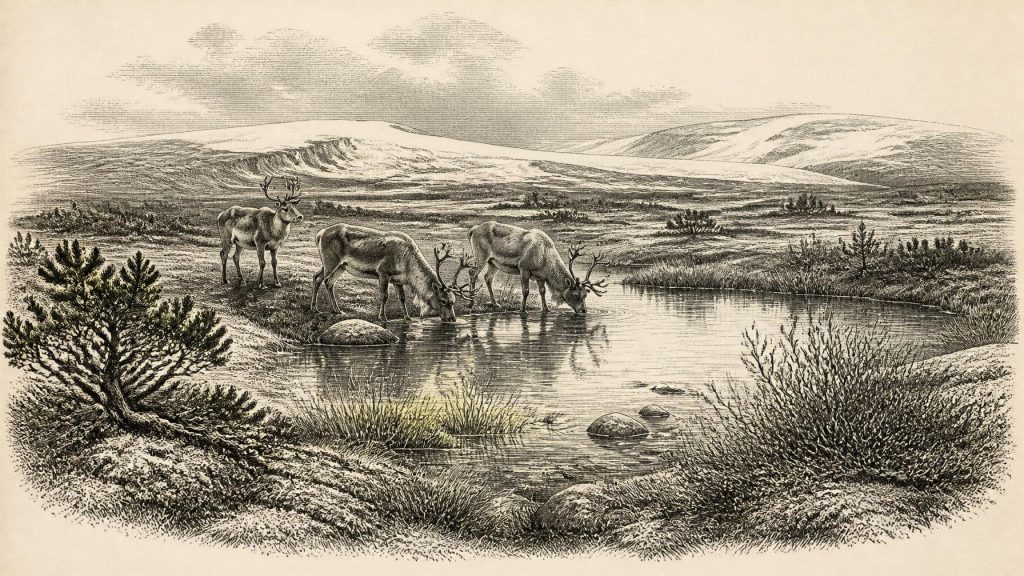
30,658 BCE cannot be identified as a precise Irish historical date, but falls within a broad Late Pleistocene range. Derryvree, County Fermanagh, preserves freshwater sediments indicating a cold, open, periglacial wetland with sedges, dwarf willow, juniper, aquatic plants and insects, later buried by ice. Expanding, uneven ice sheets made conditions and access variable. Castlepook Cave, County Cork, records cold-adapted fauna including mammoth, reindeer, giant deer, predators and lemmings, though remains span episodes. A possibly cut-marked reindeer femur may indicate intermittent Upper Palaeolithic butchery, not settlement. No evidence supports contemporary communities, institutions or cultural identities; environmental change is the principal history.
Dateline
30,658 BCE is a modern calendar label, not a date that can be identified in the Irish archaeological record with year-by-year precision. No written calendar, named community, settlement sequence or annually resolved deposit allows historians to say what happened in Ireland in that particular year. The responsible approach is to place it within the Late Pleistocene, broadly Marine Isotope Stage 3, and to use calibrated ranges rather than an invented event. The closest important Irish environmental evidence comes from Derryvree, near Maguiresbridge in County Fermanagh, while a cave assemblage at Castlepook near Doneraile, County Cork, illuminates the animals – and perhaps the intermittent human visitors – of this unstable age.
A Date Within a Wide Range
The requested year falls within the broad calibrated range associated with the Derryvree freshwater deposits. Road-cutting through a drumlin there in 1969 exposed fine sands, silts and organic mud sealed between two layers of glacial till. A radiocarbon determination, BIRM-166, gave an age of 30,500 radiocarbon years before present, with a substantial margin of error. Calibrated with modern methods, it corresponds approximately to 36,900–31,700 calibrated years before present, or about 34,950–29,750 BCE. Thus 30,658 BCE sits within the possible span, but it cannot be fixed to a particular layer, season, generation or local episode.
This distinction matters. Radiocarbon years are not calendar years, because atmospheric carbon-14 has varied through time; calibration converts a laboratory measurement into a probability range rather than an exact historical anniversary. The Derryvree sequence is consequently powerful evidence for an interval of cold, ice-free or locally ice-free conditions in south Fermanagh, but not a diary of one year. Its deposits had already accumulated before a later ice advance buried and protected them beneath till. Their survival is exceptional precisely because later glaciation destroyed, displaced or deeply buried so much of Ireland’s earlier landscape.
A Wetland Beneath the Ice
Derryvree offers a rare glimpse of an Irish environment that existed between major phases of glaciation. The organic sediments contained pollen, plant macrofossils, mosses and insect remains. Together these indicate a largely open, treeless and frost-affected landscape, not a wooded countryside resembling later Ireland. Grasses and sedges belonged to the vegetation mosaic, while the plant evidence included mosses, dwarf willow, juniper, mountain-avens, bogbean and aquatic plants such as water-milfoil. The combination suggests damp hollows, shallow freshwater, sedgy margins and sparse ground vegetation alongside drier exposed surfaces.
Such evidence should be read carefully. A seed, leaf fragment or pollen grain establishes that a plant occurred somewhere within the catchment supplying the deposit; it does not map every hillside or prove a stable climate across the whole island. Equally, a freshwater basin in Fermanagh does not mean that all Ireland was ice-free. Yet the site does establish that, during part of the dated interval, local conditions could sustain open-water and wetland communities despite a severe periglacial climate. It is the best direct evidence for the ordinary physical world surrounding this nominal year: thawed summer margins, waterlogged sediment, low-growing plants, insects and repeated freezing.
The word periglacial is important. It describes terrain shaped by intense cold and seasonal freeze-thaw near ice masses, rather than necessarily lying beneath permanent glacier ice. Frost shattered exposed rock, disturbed soils and limited tree growth. Seasonal change may have been pronounced: short productive summers could support plants, insects and grazing animals, while winters brought prolonged cold and snow cover. The Derryvree record therefore counters both an image of a uniformly sterile, glacier-covered island and an equally misleading picture of a mild refuge. It records a demanding, shifting tundra-like landscape.
Ice in Motion, Not a Fixed Map
Ireland’s wider setting was changing rapidly on geological timescales. Around 31,000 years before present, reconstructions of the British–Irish Ice Sheet show growing ice in northern and upland areas, but acknowledge large uncertainties in the exact position of its margins. By about 30,000 years before present, modelling and geomorphological synthesis suggest expansion of ice over northern and central Ireland, with smaller ice masses in the south-west. This was well before the most extensive phase of the Last Glacial Maximum, generally placed later, around 27,000–23,000 calibrated years before present.
For 30,658 BCE, then, no responsible reconstruction should draw a neat national boundary between “ice” and “habitable land”. Ice sheets advanced and retreated unevenly; uplands, basins, coasts and interior lowlands experienced different conditions. The evidence permits an interpretation of increasing climatic severity and regional ice growth, not a claim that every location was simultaneously covered. Lower global sea level altered coastlines and shelf landscapes, but the precise accessibility of Ireland from Britain or continental Europe at any one moment remains uncertain. Any human or animal movement must be considered against that changing geography, not assumed to have followed a single permanent land route.
Castlepook’s Animal World
North Cork’s Castlepook Cave, also known as Mammoth Cave, preserves Ireland’s most important assemblage of Middle Midlandian or MIS 3 large-mammal remains. The fauna includes woolly mammoth, reindeer, giant deer, brown bear, wolf, Arctic fox, mountain hare, stoat, collared and Norwegian lemmings, and spotted hyaena. This is compelling evidence that parts of Ireland periodically supported a varied cold-stage fauna. Reindeer and lemmings are especially consistent with open, cold habitats; mammoth, giant deer and large predators indicate a landscape far removed from historic Ireland.
It would nevertheless be wrong to turn the cave list into a photograph of a single day. Caves accumulate bones by many routes. Carnivores may drag in prey; animals can die naturally in fissures; water and sediment can move remains; and early excavators did not record deposits to modern stratigraphic standards. Some Castlepook material may derive from different episodes separated by thousands of years, and later re-dating has shown that older results require reappraisal. The assemblage securely demonstrates regional faunal possibilities across a broad period. It cannot prove that mammoth, hyaena and every listed animal stood together beside the same Fermanagh pool in 30,658 BCE.
Even so, the ecological implications are substantial. Predators and scavengers had to be accommodated within food webs based on herbivores and smaller mammals. Seasonal migrations, local extinctions and recolonisations were likely consequences of climatic oscillation and moving ice margins. For people, should people have been present, this was a country of animal resources but also exceptional risk: cold exposure, uncertain routes, dangerous predators and a landscape with little dependable shelter beyond caves, rock overhangs and temporary structures that have not survived.
The Reindeer Femur and Human Presence
A reindeer femur from Castlepook has made this period unusually important in Irish archaeology. Zooarchaeological examination has interpreted a deep mark on the bone as damage caused by a sharp stone tool while the carcass was fresh. The bone has been reported as approximately 33,000 radiocarbon years old. If the cut-mark interpretation is upheld, it is evidence that people processed a reindeer in Ireland during the Upper Palaeolithic, enormously earlier than the better-established terminal-Pleistocene evidence from Alice and Gwendoline Cave in County Clare.
That claim must remain proportionate to the object. A modified bone may document one act of butchery; it does not demonstrate a permanent population, a village, a hunting territory or an unbroken ancestry leading to later Irish communities. Nor has Castlepook produced a securely associated hearth, living floor, stone-tool concentration, dwelling, grave or food store of this age. The cave’s complicated depositional history adds another reason for caution. Current excavation has sought surviving undisturbed Pleistocene deposits, because carefully recorded context is essential to testing old collections and refining their chronology.
What Cannot Be Written
There is no evidence from Ireland around this date for political institutions, rulers, diplomacy, organised warfare, farming, herding, trade networks, seafaring communities, formal religion, writing or named languages. There are no known houses, fields, monuments, burials or works of art securely attributable to this narrow period. It is therefore misleading to fill the gaps with imagined tribes, “Irish” identities or a calendar of prehistoric events. The terms Ireland and Irish are geographical conveniences here, not identities that can be projected into the deep Pleistocene past.
If a small number of Upper Palaeolithic hunter-gatherers did reach the island intermittently, their social life would have depended on mobility, practical knowledge of weather and animal behaviour, co-operation and the maintenance of kin connections beyond any one camp. That is an inference from comparative hunter-gatherer archaeology, not direct evidence from Derryvree or Castlepook. No material trace currently permits a responsible account of their beliefs, speech, family structure or relations with other groups.
An Environmental History
The principal development around 30,658 BCE was environmental. A wetland at Derryvree lay within a cold, open and periglacial landscape; ice was growing and rearranging the geography of the island; and cold-adapted mammals occurred in at least some regions. The possible cut-mark on a Castlepook reindeer femur gives the period a tantalising human dimension, but it remains a slender trace. Ireland at this depth of time is best understood not as a stage for dated political history, but as a changing Late Pleistocene frontier whose buried muds, bones and tills preserve fragments of worlds repeatedly remade by climate.
Primary Sources
- Palaeoecology
- A Middle Midlandian Freshwater Series at Derryvree, Maguiresbridge, County Fermanagh, Northern Ireland
- A Reconsideration of the Radiocarbon Dating of the Marine Isotope Stage 3 Fauna from Southern Ireland
- New Insights on the Fauna of Ireland’s Younger Dryas and Early Holocene from Alice & Gwendoline Cave
- Growth and Retreat of the Last British–Irish Ice Sheet, 31,000 to 15,000 Years Ago: the BRITICE-CHRONO Reconstruction
- Growth and Retreat of the Last British–Irish Ice Sheet, 31,000 to 15,000 Years Ago: the BRITICE-CHRONO Reconstruction
- Trimlines, Blockfields and the Vertical Extent of the Last Ice Sheet in Southern Ireland
- The Deglaciation of the Western Sector of the Irish Ice Sheet from the Inner Continental Shelf to its Terrestrial Margin
- Timing and Pace of Ice-sheet Withdrawal Across the Marine–Terrestrial Transition West of Ireland During the Last Glaciation
- Response of the Irish Ice Sheet to Abrupt Climate Change During the Last Deglaciation
- Spatio-temporal Dynamics of Speleothem Growth and Glaciation in the British Isles
- The IntCal20 Northern Hemisphere Radiocarbon Age Calibration Curve (0–55 cal kBP)
- IntCal20
- Testing and Improving the IntCal20 Calibration Curve with Independent Records
- Archaeological Heritage of County Cork
- Heritage Artefacts of County Cork
- 2022:564 – Castlepook Cave, Castlepook South, Cork
- CastlePook Caves
- Mammoth Cave
- Pleistocene Vertebrates in the British Isles
- Ireland: Submerged Prehistoric Sites and Landscapes
- The Last Glacial Maximum British–Irish Ice Sheet: a Reconstruction Using Digital Terrain Mapping





