
BIRM-166’s Tundra Archive30571 BCE
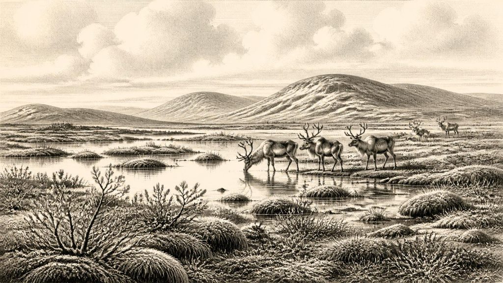
At 30,571 BCE, Ireland has no written history; evidence comes from environmental archives. BIRM-166, organic freshwater silts at Derryvree, County Fermanagh, dated broadly to 36,900–31,700 cal BP, records a locally ice-free wetland between glacial advances. Plant and insect remains indicate cold, wet, largely treeless tundra-like terrain with seasonal productivity. Castlepook Cave, County Cork, preserves time-mixed remains of reindeer, mammoth, giant deer and predators, showing intermittent links with north-west European fauna. A possibly cut-marked reindeer bone suggests, but cannot confirm, early human visits. No settlement, society or culture is securely evidenced. Subsequent British–Irish Ice Sheet expansion reshaped landscapes and obscured records.
Dateline
The label 30,571 BCE is a useful modern waypoint, but it is not a year for which Ireland possesses a chronicle. There were no written records, named rulers, dated settlements or calendar-keeping institutions on the island. Modern calendar-year precision is therefore unavailable. Expressed in the scientific convention of calibrated years before present, with “present” fixed at 1950, the notional date falls about 32,520 cal BP. It belongs to the later part of Marine Isotope Stage 3, a long and climatically unstable stretch of the last Ice Age, well before the Last Glacial Maximum. The responsible history of Ireland at this point is consequently one of deposits, fossils, landforms and probability, rather than events.
A Wetland Between Ice Advances
The closest and most informative Irish evidence is BIRM-166, a radiocarbon determination from organic freshwater silts exposed at Derryvree, near Maguiresbridge in County Fermanagh. Road works cut through a drumlin in 1969 and revealed a remarkable sequence: a lower glacial till, then fine sands and organic-rich freshwater sediments, capped by another thick till. Till is the unsorted clay, stones and debris left by glacier ice. The arrangement establishes an important order of events. Ice had occupied this part of Fermanagh; an interval followed in which water, sediment and vegetation accumulated; later ice or ice-related deposits buried and protected the record.
The Derryvree organic material returned a conventional radiocarbon age of 30,500 radiocarbon years BP, with a large uncertainty. Calibration produces a broad range commonly expressed as approximately 36,900–31,700 cal BP. That range encompasses 30,571 BCE, but it does not date a particular day, season, generation or episode at the site. The sediment bed accumulated over time, and its radiocarbon result is itself a statistical estimate. It can responsibly demonstrate that northern Ireland contained locally ice-free freshwater ground during part of this broad interval. It cannot demonstrate that the whole island was simultaneously open, nor that Derryvree looked exactly the same throughout the entire calibrated range.
This distinction matters because Ireland’s ice-age geography was highly regional. Conditions at a wet Fermanagh hollow, a Cork limestone cave, a western shelf edge and an upland plateau need not have matched one another. The later expansion of the British–Irish Ice Sheet eroded, redeposited or sealed many older landscapes. Derryvree is valuable precisely because the intervening wetland survived between glacial deposits. It is an exceptional local archive, not a complete map of Ireland.
Cold Water, Open Ground
The plant and insect evidence from Derryvree provides the clearest available picture of everyday environmental conditions relevant to this date. Pollen, plant macrofossils, mosses and insects indicate freshwater beside open, mostly treeless ground. Sedges, mossy vegetation, low herbs and aquatic plants belonged to a cold, wet mosaic of shallow water, saturated margins and frost-affected terrain. Irish Quaternary researchers have described the setting as tundra or muskeg-like: a useful ecological comparison for a waterlogged, organic-rich landscape, rather than a claim that a modern northern bog was reproduced exactly in Pleistocene Fermanagh.
There may have been scattered shrubs, including dwarf willow and juniper in favourable localities, but the evidence does not support a familiar wooded Ireland. Tree pollen can travel considerable distances, and a few grains cannot overturn the overall signal of sparse, open vegetation. Summers could still have brought biologically active pools, insects, growing sedges and grazing opportunities; winters and much of the surrounding terrain were severe. Periglacial processes—repeated freezing and thawing, frost disturbance and perhaps locally frozen ground—would have shaped soils, water movement and the plants able to survive.
Such an environment was not lifeless. Freshwater plants and invertebrates show that seasonal ecological productivity existed. Yet the record offers no basis for calculating herd sizes, snowfall, average temperature or the precise outline of a lake in 30,571 BCE. The strongest conclusion is modest but significant: within the broad dating range, part of Ireland supported a functioning cold-stage wetland ecosystem between episodes of glaciation.
Caves and Animal Pathways
County Cork supplies a different, more difficult, line of evidence. Castlepook Cave near Doneraile, in the Awbeg valley beneath the Ballyhoura Hills, has yielded one of Ireland’s richest Late Pleistocene animal assemblages. Material recovered during nineteenth- and early twentieth-century excavations includes remains attributed to reindeer, woolly mammoth, giant deer, brown bear, wolf, fox, Arctic fox, hare, lemmings and spotted hyaena. Together, these finds demonstrate that Ireland was intermittently linked to the wider north-west European fauna during the long period before the Last Glacial Maximum.
They do not, however, form a single scene. Cave deposits can combine bones accumulated over thousands of years through carnivore activity, natural deaths, water movement, collapse and excavation practices that did not meet modern standards. Improved dating has shown that some older Irish cave chronologies require reassessment. A bone establishes that an animal died, was carried in, or was deposited at a cave; it does not automatically prove a local breeding population, a particular season, or coexistence with every other species in the collection.
The Castlepook fauna nevertheless gives scale to the Derryvree landscape. Reindeer and cold-adapted small mammals fit an open northern environment, while mammoth, giant deer and large predators indicate ecological connections across lands and shallow seas now divided by water. Sea level was much lower than today, but the evidence does not permit a confident claim that there was an open, continuous land bridge to Ireland in this exact year. Animal dispersal may have occurred during changing periods of lowered sea level, coastal exposure and ice-sheet reorganisation. “Connection” is safer than a simple, fixed bridge.
The Human Question
A reindeer femur from Castlepook has been publicised as carrying a deep incision interpreted by zooarchaeologist Ruth Carden as a stone-tool mark made during carcass processing. The bone has been reported as approximately 33,000 years old, making it highly relevant to the broad period around 30,571 BCE. If the mark is confirmed as human-made and contemporary with the animal’s death, it would indicate that Upper Palaeolithic people reached Ireland far earlier than the formerly accepted late-glacial evidence.
That conditional language is essential. The specimen is not a securely excavated hearth with tools, food waste and occupation floors in a sealed layer. Its cave context is complicated, and a radiocarbon date on bone and the identification of a surface incision answer different questions. The first concerns the age of surviving animal collagen; the second requires taphonomic judgement about whether a sharp tool, carnivore, trampling or another process produced the mark. Current excavations at Castlepook are seeking undisturbed deposits, lithics, hearth evidence and further modified bone that could test the hypothesis.
No permanent settlement can responsibly be placed in Ireland at this date. There are no known houses, campsites, graves, stone-tool assemblages or hearths securely dated to 30,571 BCE. Nor is there evidence for a named people, population size or unbroken ancestry leading to later Irish communities. A brief visit by mobile hunters, perhaps to process a carcass, would be a very different proposition from year-round habitation. Even that limited possibility remains an interpretation awaiting stronger corroboration.
What Cannot Be Written
Political affairs, diplomacy and warfare leave no identifiable record for Ireland at this point. There are no polities, leaders, borders, alliances or conflicts that can be reconstructed. The same restraint applies to religion: no ritual sites, burials, images, ornaments or sacred objects can be assigned to this Irish horizon. Upper Palaeolithic groups elsewhere in Europe made sophisticated stone and bone technologies, personal ornaments and cave art, but those continental achievements are context, not evidence that such practices occurred in Ireland.
There is likewise no direct evidence for an Irish economy or trade network. It would be misleading to describe hunting strategies, clothing, boats, exchange systems or social roles as though Derryvree and Castlepook documented them. The wetland indicates resources that animals, and potentially people, could have used; it does not reveal ownership, commerce or custom. If humans did reach Ireland, their practical knowledge would necessarily have included movement through a harsh seasonal landscape, but that is an inference from environmental challenge, not a recorded cultural fact.
Ice on the Horizon
The larger regional development was the uneven growth and rearrangement of the British–Irish Ice Sheet. Ireland at roughly 32,520 cal BP stood before the later maximum of that ice sheet, conventionally placed around 26,000–23,000 years ago, although different sectors advanced and retreated at different times. Derryvree’s inter-till wetland shows that northern Ireland was not under continuous ice throughout the preceding cold stage. Later glaciation would transform the island profoundly, scouring bedrock, depositing tills and drumlins, altering drainage and removing much of the fragile archaeological evidence that might once have survived.
For 30,571 BCE, then, Ireland is best envisaged neither as a wholly frozen void nor as a settled prehistoric homeland. It was a changing, locally habitable cold landscape: open ground around pools and sedges in Fermanagh; animal movement through wider north-west European ecological corridors; caves in Cork preserving a time-mixed record of large mammals and predators; and an ice sheet whose future advances would conceal much of what came before. BIRM-166 does not provide a story of a single year. Its importance is greater: it preserves proof that, amid the instability of the Ice Age, freshwater life endured in Ireland between the glaciers.
Primary Sources
- A Middle Midlandian Freshwater Series at Derryvree, Maguiresbridge, County Fermanagh, Northern Ireland
- The Quaternary of the North of Ireland: Field Guide 17
- References and Recommended Reading: IQUA Field Guide 16
- Quaternary Deposits and Glacial Stratigraphy in Ireland
- Trimlines, Blockfields and the Vertical Extent of the Last Ice Sheet in Southern Ireland
- Growth and Retreat of the Last British–Irish Ice Sheet, 31,000 to 15,000 Years Ago: the BRITICE-CHRONO Reconstruction
- The Timing and Magnitude of the British–Irish Ice Sheet Between Marine Isotope Stages 5d and 2
- Maximum Extent and Readvance Dynamics of the Irish Sea Ice Stream and Irish Sea Glacier Since the Last Glacial Maximum
- Timing and Pace of Ice-Sheet Withdrawal Across the Marine–Terrestrial Transition West of Ireland During the Last Glaciation
- Sedimentology and Chronology of the Advance and Retreat of the Last British-Irish Ice Sheet on the Continental Shelf West of Ireland
- The Irish Quaternary Fauna Project
- New Insights on the Fauna of Ireland’s Younger Dryas and Early Holocene from Alice & Gwendoline Cave
- Ireland’s Palaeolithic Archaeology – Fleeting Footprints in a Frozen Land
- Heritage Artefacts of County Cork
- Archaeology Research Excavation Grant 2022: Castlepook Cave, Co Cork
- Castlepook Cave, Co. Cork, 2022 Excavation Report
- The Colonization of Ireland: A Human Ecology Perspective
- The Mesolithic in Ireland: When Was It?
- The IntCal20 Northern Hemisphere Radiocarbon Age Calibration Curve (0–55 cal kBP)
- A Chronology for the Last Glacial Period Based on Synchronized Greenland Ice-Core Records: Refinement and Extension of the INTIMATE Event Stratigraphy
