

Maguirebridge’s Permafrost Waters30613 BCE
About 30,613 BCE, a modern label rather than a precise historical date, Ireland lay in the unstable later Marine Isotope Stage 3 of the Last Ice Age. It was a shifting patchwork of ice, periglacial terrain and occasional ice-free habitats, not uniformly frozen or temperate. Derryvree, County Fermanagh, preserves freshwater silts between glacial tills, dated broadly to 36,900–31,700 years ago. Its pollen, plants and insects reveal treeless tundra wetlands. Cave remains demonstrate diverse cold-adapted fauna, while a possibly butchered Castlepook reindeer bone suggests, but cannot prove, early human visits. Environmental change, rather than identifiable societies or events, defines this period.
Dateline
The label 30,613 BCE is useful only as a modern organising device. No written calendar, year-count or event sequence existed in Ireland at this depth of time, and archaeological science cannot identify what happened in one particular solar year. In conventional archaeological terms, it lies roughly 32,563 years before AD 1950, but that conversion must not be mistaken for a precise date. Radiocarbon ages require calibration and are expressed as probability ranges; sediments may also represent years, centuries or longer episodes of deposition. The responsible subject is therefore Ireland during the later part of Marine Isotope Stage 3, a fluctuating interval of the Last Ice Age, rather than an invented occurrence in a named year.
A Cold Interval, Not an Empty Map
Ireland at this broad horizon was not the familiar green, wooded island of later millennia. It was part of the north-western fringe of Ice Age Europe, where climate, ice and sea level altered the shape and habitability of the land repeatedly. The Last Glacial Maximum, when the British–Irish Ice Sheet reached its greatest later extent, still lay ahead; recent reconstructions place its maximum extent in different sectors between about 30,000 and 22,000 years ago, with peak ice volume later, around 23,000 years ago. Around 30,613 BCE, therefore, Ireland was in a phase of severe climatic instability and ice-sheet growth rather than securely at that later maximum.
It would be wrong, however, to draw Ireland as either wholly ice-covered or wholly temperate. The evidence indicates a patchwork whose limits changed through time. Glaciers and ice sheets were capable of overwhelming large regions, while other places supported frost-affected ground, shallow water, vegetation and animals during milder or less glacial phases. Much of the earlier record has been eroded, buried or reworked by subsequent ice advances. What survives is consequently precious but local: a buried wetland in County Fermanagh, cave deposits in County Cork, landforms on hills and seabed, and the materials carried or left behind by ice.
The Derryvree Archive
The clearest Irish environmental evidence relevant to this period comes from Derryvree, near Maguiresbridge in County Fermanagh. Roadworks exposed organic silts and fine sands sandwiched between two substantial till layers within a drumlin. Till is sediment laid down by glacier ice; the Derryvree sequence therefore records a freshwater and terrestrial episode between glacial advances. Its conventional radiocarbon determination, BIRM-166, was 30,500 radiocarbon years before present, with a wide laboratory uncertainty. Calibrated treatments place the deposit broadly within approximately 36,900–31,700 calibrated years before present.
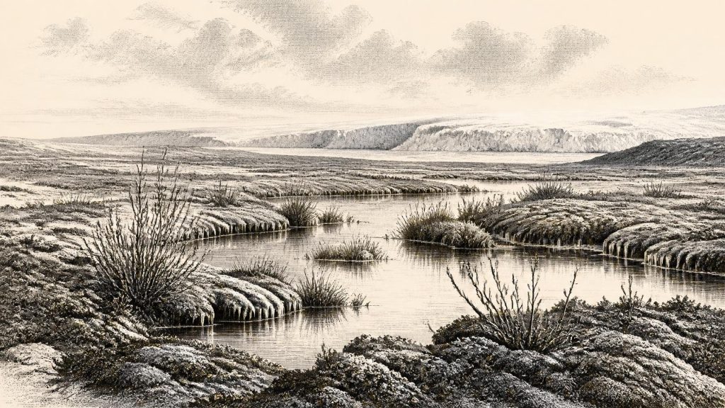
That range overlaps the broad chronological horizon represented by 30,613 BCE, but it cannot prove that its plants or insects lived in that particular year. It does, nevertheless, provide Ireland’s best-supported local picture of conditions around this stretch of the Late Pleistocene. Pollen, plant macrofossils, mosses and insect remains indicate an open, treeless tundra or tundra-steppe landscape with wet ground and freshwater margins. Finds reported from the deposit include sedges, mosses, bogbean (Menyanthes trifoliata), dwarf willow, mountain-avens and water-milfoil. Such species do not create a full photograph of a vanished landscape, but together they demonstrate that cold-season water and seasonal thaw sustained plant communities in an environment strongly shaped by frost.
The importance of this evidence is methodological as much as scenic. No dwelling floor, hearth, field boundary or grave has been excavated at Derryvree. The site speaks through minute organic remains and their position beneath later glacial deposits. It supports the conclusion that at least part of Fermanagh was ice-free during the formation of the freshwater sediments. It does not establish a permanent human settlement, a political territory or an Irish population.
Wetlands at the Ice Margin
The Derryvree landscape was probably harsh but not lifeless. Periglacial conditions mean a terrain influenced by freezing and thawing near an ice margin, rather than necessarily lying beneath ice. Short summers could open pools, channels and sedge-rich ground; long winters, frozen soils, sparse cover and strong winds would have imposed severe limits. Local conditions mattered greatly. A sheltered freshwater basin could preserve aquatic plants and wetland mosses while exposed slopes and higher ground remained more barren.
These wetlands were not merely picturesque refuges. They formed habitats within a wider food web, offering vegetation, water and insect life in a country with little or no woodland. The precise list of animals at Fermanagh at this time cannot be read directly from the plant bed. Yet Irish Pleistocene cave collections demonstrate that cold-adapted and open-country mammals reached the island during the wider last glacial cycle: reindeer, hare, fox, wolf, brown bear, spotted hyaena and woolly mammoth are among the faunal evidence known from different sites and dates. Their presence should not be compressed into one simultaneous community. Each bone must be dated, its context assessed and its route into a cave understood.
Castlepook and the Human Question
County Cork’s Castlepook Cave, near Doneraile, is central to the question of whether people ever entered Ireland before the ice intensified. Its antiquarian excavations produced a notable Ice Age faunal assemblage, including mammoth and reindeer remains. A reindeer femur has been publicly interpreted as bearing a deep cut or chop mark made during butchery with a stone tool and has been associated with an age of roughly 33,000 years. If that interpretation and chronological association are sustained, it would indicate a very early human visit to Ireland in the Upper Palaeolithic.
For this article’s date, caution is essential. Castlepook does not presently provide a securely excavated settlement of 30,613 BCE: there is no associated house, hearth, lithic assemblage, burial or occupation surface from which to reconstruct a community. Old cave collections can have complex histories of excavation, movement and recording. A bone date is primarily the date of the animal’s death, not automatically the moment at which a person handled it. Natural damage can also sometimes resemble cultural modification. The find is therefore significant evidence under investigation, not licence to populate Ireland with named hunters, families, language groups or traditions.
The more secure evidence for Pleistocene human activity in Ireland is much later. At Alice and Gwendoline Cave in County Clare, a brown-bear bone with stone-tool cut marks has been directly dated to the closing stages of the Pleistocene, around 12,800–12,600 calibrated years before present. That later evidence shows why the distinction matters: a clearly dated act of butchery can establish human presence, but it cannot retrospectively turn every earlier animal bone or possible incision into proof of occupation.
Movement Without Borders
There were no Irish kingdoms, chiefs, diplomatic alliances, armies or borders that the evidence can identify for this period. Nor is there evidence for farming, herding, metalworking, monuments, formal religion, writing, schools or long-distance trade networks in Ireland. These absences are not failures of imagination; they are the limits imposed by the record. If people did reach the island intermittently during Marine Isotope Stage 3, they would have been mobile foragers using the resources and routes available in a cold, changing landscape. That is an inference from the European Upper Palaeolithic context and the possible Castlepook evidence, not a demonstrated description of social life in Ireland.
Lower global sea levels altered coastlines and the geography of travel. Ireland was not necessarily configured as it is today, and the submerged shelves of the Irish and Celtic seas hold landscapes that later rising seas drowned. Nonetheless, low sea level did not guarantee an easy overland journey at every moment: ice streams, glacial lakes, rivers, exposed sediment plains and changing sea channels all affected movement. The route taken by any early visitor to Castlepook, if visitors were present, remains unknown.
What Can Be Said Responsibly
The great development around 30,613 BCE was environmental transformation. Ireland lay within a volatile Ice Age world in which cold, periglacial wetlands could exist between episodes of extensive glaciation. The Derryvree sediments record a treeless freshwater landscape in Fermanagh, later sealed beneath advancing ice. Castlepook shows that southern Irish caves preserve a much broader Pleistocene faunal archive and a tantalising, still limited possibility of very early human activity.
This was not yet a historical Ireland of peoples and events. It was a physical Ireland being remade by ice, frost, water, plants and animal movement. The most honest year-by-year account is therefore one that preserves uncertainty. A numbered BCE year can point readers towards the evidence, but the evidence itself speaks in calibrated ranges, buried layers and probabilities. Its achievement is not to supply a story that cannot be known; it is to reveal that even in a severe and changing Ice Age, parts of Ireland contained living freshwater landscapes before the next advance of the ice.
Primary Sources
- A Middle Midlandian Freshwater Series at Derryvree, Maguiresbridge, County Fermanagh, Northern Ireland
- Growth and retreat of the last British–Irish Ice Sheet, 31,000 to 15,000 years ago: the BRITICE-CHRONO reconstruction
- The timing and magnitude of the British–Irish Ice Sheet between Marine Isotope Stages 5d and 2
- New data for the Last Glacial Maximum in Great Britain and Ireland
- Radiocarbon constraints on the age of the maximum advance of the British–Irish Ice Sheet in the Celtic Sea
- Last Glacial Maximum cirque glaciation in Ireland and implications for reconstructions of the Irish Ice Sheet
- Trimlines, blockfields and the vertical extent of the last ice sheet in southern Ireland
- Dimensions and chronology of the last ice sheet in Western Ireland
- Stratigraphic and palaeo-geomorphological evidence for the glacial-deglacial history of the last British-Irish Ice Sheet in the north-western Irish Sea
- The West Corrib moraine system as evidence for a brief glacial readvance in Ireland during overall Heinrich Stadial 1 deglaciation
- Figure 6: The subdivision of the Quaternary Period in Ireland
- Irish Quaternary Association: Field Guides
- Irish Quaternary Association: Outreach and Education Resources
- BRITICE-CHRONO: Aims, Hypotheses and Outcomes
- BRITICE-CHRONO: Project Introduction
- New insights on the fauna of Ireland's Younger Dryas and Early Holocene from Alice & Gwendoline Cave
- First evidence of a Late Upper Palaeolithic human presence in Ireland
- The Archaeological Heritage of County Cork
- The Mesolithic in Ireland: when was it?
- Deglaciation of the Burren glacio-karst, western Ireland, during Termination 1: Implications for North Atlantic climate and karstification





