
Castlepook’s Cut-Mark Horizon30454 BCE
30,454 BCE is a modern chronological label within a broad Late Pleistocene range, not a recorded Irish year. Derryvree, County Fermanagh, preserves freshwater silts between tills, showing a locally ice-free interval with cold, wet, open vegetation and periglacial conditions. Castlepook Cave, County Cork, contains a long, disturbed faunal archive including mammoth, reindeer, giant deer, bears and hyaenas, rather than a single contemporaneous assemblage. A cut-marked reindeer femur may indicate brief human carcass processing around this period, but cannot prove settlement. Ireland experienced regionally changing ice, uncertain coasts and habitats, with no evidence for polities, farming, permanent villages or sustained occupation.
Dateline
30,454 BCE is not a year for which Ireland possesses a historical event, named people or calendar record. It is a modern label placed on a point about 32,403 years before AD 1950, within the Late Pleistocene and Marine Isotope Stage 3 (MIS 3), an unstable phase of the last Ice Age. Modern calendar-year precision is not available at this depth of time. The evidence comes instead from deposits accumulated over long intervals, radiocarbon measurements with statistical uncertainty, animal bones often lacking modern excavation contexts, and wider reconstructions of ice-sheet change.
The responsible history of Ireland at this horizon is therefore environmental and archaeological rather than political. It concerns cold freshwater ground at Derryvree in County Fermanagh; the changing reach of ice; and the Ice Age animals preserved in Castlepook Cave near Doneraile, County Cork. One marked reindeer bone from that cave offers a potentially important, but still limited, clue to human activity. It does not establish a settlement, a people, or a year-specific episode.
A Date Within Ranges
Archaeologists conventionally reckon radiocarbon years “before present”, with present fixed at AD 1950. A BCE label and a radiocarbon age are not interchangeable. Atmospheric carbon-14 has varied through time, so a radiocarbon result has to be calibrated against independently dated records. At more than 30,000 years ago, the outcome is a broad probability range rather than a date that can be assigned to a particular season, lifetime or generation.
The nearest especially informative Irish sequence is the Derryvree freshwater series, exposed during road works through a drumlin near Maguiresbridge in 1969. Organic silts and fine sands lay between two separate bodies of till: unsorted sediment deposited by glacier ice. The organic bed produced the conventional radiocarbon determination BIRM-166, 30,500 radiocarbon years BP, with an uncertainty of +1,170 and −1,030 years. Published calibrations have placed the deposit broadly at about 36,900–31,700 calibrated years BP. The nominal year 30,454 BCE, about 32,403 cal BP, lies within that wide horizon, not at a detectable beginning or ending point.
Freshwater Between the Tills
Derryvree provides a rare sequence with a clear local order. Ice had deposited one till sheet; subsequently, water, mineral sediment, plants and small animals accumulated in a freshwater setting; later ice buried the deposit beneath another till. This is firm evidence that the immediate Fermanagh locality was ice-free for a period between two glacial episodes. It is not proof that all Ireland was ice-free at once, nor that the landscape remained unchanged throughout the entire calibrated range.
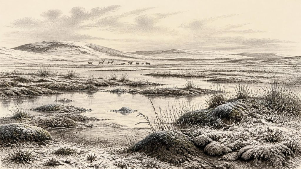
The silts contain a flora and fauna described as fully glacial in character. Mosses, herbaceous pollen, sedges and aquatic plants point to open, cold wet ground, while fossil insects add evidence of a severe periglacial regime. “Tundra” is a useful shorthand, provided it is not mistaken for a simple, uniform plain. The Derryvree basin appears to have included freshwater, damp margins and patches of low vegetation. On exposed ground, plant cover may have been sparse; in sheltered wet places, water and summer growth could support a more varied miniature landscape.
This was not the later wooded island of Mesolithic or Neolithic Ireland. Trees are not supported as a substantial local cover by the Derryvree evidence. Frost action, seasonal thaw, snow cover and strong seasonal contrasts would have shaped soils and drainage. The site preserves an ecological refuge of sorts: not a mild sanctuary, but a living wetland in a cold region where organic traces could accumulate before later ice sealed them away.
Animals and Cave Archives
Castlepook Cave, a limestone cave system near Doneraile, gives the period an animal dimension that Derryvree cannot supply. Its deposits have yielded remains of woolly mammoth, reindeer, giant deer, brown bear and spotted hyaena, with Arctic fox, wolf and lemmings represented in later Ice Age levels. The cave is Ireland’s richest known archive for vertebrate fauna leading towards the Last Glacial Maximum, and dated individual bones span a very long interval, roughly 45,700 to 19,950 years BP.
That long span is crucial. Castlepook was a repository, not a sealed snapshot. Hyaenas may have carried prey remains into its chambers; water movement, earlier excavations and disturbance have mixed or obscured contexts. The presence of a mammoth bone and a reindeer bone does not demonstrate that the animals encountered one another, much less that every species listed from the cave was present in 30,454 BCE. It does show that, across the surrounding millennia, Ireland supported or was reached by large grazing mammals and their predators during episodes when suitable open habitats and routes existed.
Reindeer are especially suggestive of the kind of country represented at Derryvree: open, cold and seasonally productive rather than densely forested. Their movements need not have followed a single island-wide route, and the evidence cannot reconstruct a migration in any particular year. Yet the combined wetland and cave records make a changing mosaic more plausible than either extreme image of an entirely ice-covered Ireland or a wholly benign, continuously habitable one.
The Cut-Mark Question
A fragment of reindeer femur from Castlepook has attracted particular attention because zooarchaeologist Ruth Carden identified a deep incision interpreted as consistent with cutting by a sharp stone tool during carcass processing. Public reporting has associated the bone with an age of about 33,000 years. If the mark proves to be anthropogenic and contemporary with the death of the animal, it would indicate that people visited Ireland in the broad period relevant to this article, perhaps to process a reindeer carcass.
That conclusion must remain narrow. A radiocarbon date on a bone dates the animal’s death within a range; it does not independently date the mark, identify its maker, or reveal whether the animal was killed at the cave. Nor has Castlepook yielded a securely associated dwelling, hearth, stone-tool assemblage, burial or stratified butchered-animal concentration of this age. The cave’s earliest investigations, conducted in the early twentieth century, did not meet modern standards of contextual recording. The marked femur is important evidence under continuing scrutiny, but it is not evidence for a settled Irish population.
No Polities, No Proven Settlement
There is consequently no responsible account of Irish political affairs, diplomacy, tribal territories or warfare for 30,454 BCE. No ruler, language, institution, boundary, monument or ritual practice can be attached to this date. Nor is there evidence for farming, trade networks, permanent villages or a local craft tradition. Such absences should not be recast as proof that no person ever set foot on the island: Ice Age archaeological records are fragmentary, and later ice could destroy or conceal sites. But the surviving evidence does not permit society to be reconstructed.
If people did reach Ireland during this wider interval, their presence may have been brief and highly mobile. That is an inference from the possible cut-mark and the environmental setting, not a demonstrated settlement pattern. We do not know how they travelled, whether crossings involved water, shore ice or changing exposed ground, how many people were involved, or whether visits were repeated. Equally, there is no basis for attributing belief, art, kinship systems, exchange or learning to them specifically in Ireland.
An Island in a Growing Ice System
Ireland belonged to the wider British–Irish Ice Sheet system, but ice growth was asynchronous between regions. Modern reconstructions chart major advance and retreat from about 31,000 years BP onwards and show different sectors reaching their maxima at different times, broadly between 30,000 and 22,000 years BP. The ice sheet’s maximum volume came much later, around 23,000 years BP. Those reconstructions caution against projecting the better-known Last Glacial Maximum backwards onto every part of Ireland at 32,403 cal BP.
Global sea level was lower than today because water was stored in continental ice sheets, but local relative sea level around Ireland was also affected by crustal loading, shifting ice margins and changing drainage. The shape of coasts, the status of possible routes to Britain, and the extent of exposed shelf cannot safely be specified for this nominal year. The evidence supports regional change, not a precise map.
What can be said is both modest and significant. Around the chronological horizon denoted by 30,454 BCE, parts of Ireland contained cold, open and locally ice-free environments capable of supporting freshwater vegetation and Ice Age fauna. At Derryvree, later ice preserved a fleeting organic archive between tills. At Castlepook, cave deposits retained a longer, more complicated record of animals and a possible trace of human action. Together they make this a chapter of shifting climates, vulnerable habitats and uncertain human contact—not a year of known Irish events.
Primary Sources
- A Middle Midlandian Freshwater Series at Derryvree, Maguiresbridge, County Fermanagh, Northern Ireland
- Palaeoecology
- The Subdivision of the Quaternary Period in Ireland
- Quaternary Deposits and Glacial Stratigraphy in Ireland
- The Irish Quaternary Fauna Project
- Castlepook Cave: County Geological Site Report
- Castlepook Cave, Co. Cork, 2022
- Archaeology Research Excavation Grant 2022: Final Report
- Growth and Retreat of the Last British–Irish Ice Sheet, 31,000 to 15,000 Years Ago: The BRITICE-CHRONO Reconstruction
- Maximum Extent and Dynamic Behaviour of the Last British–Irish Ice Sheet West of Ireland
- Pattern and Timing of Retreat of the Last British-Irish Ice Sheet
- New Data for the Last Glacial Maximum in Great Britain and Ireland
- Late Pleistocene Chronostratigraphy and Ice Sheet Limits, Southern Ireland
- Heinrich Events and the British-Irish Ice Sheet
- The IntCal20 Northern Hemisphere Radiocarbon Age Calibration Curve (0–55 cal kBP)
- IntCal Publications
- NOAA/WDS Paleoclimatology: North GRIP MIS3 CH4, d15N, and Temperature Data
- New Insights on the Fauna of Ireland’s Younger Dryas and Early Holocene from Alice & Gwendoline Cave
- Guide to the National Museum of Ireland
- Ireland’s Palaeolithic Archaeology: Fleeting Footprints in a Frozen Land
- Heritage Artefacts of County Cork 2021
