
Derryvree’s Moss-Detritus Silts30462 BCE
Around 30,462 BCE, Ireland’s evidence is geological rather than historical. Organic silts at Derryvree, County Fermanagh, dated approximately 30,500 radiocarbon years BP, preserve a cold, ice-free freshwater environment beneath later glacial tills. Mosses, sedges, herbs, dwarf willow and insects indicate treeless, waterlogged tundra with short growing seasons and severe winters. As the British–Irish Ice Sheet expanded, conditions varied greatly across the island. Castlepook Cave, County Cork, yielded mammoth, reindeer and hyaena remains; a possibly cut-marked reindeer bone suggests fleeting human activity. However, no contemporary settlements, tools, human remains or cultural record confirms occupation. Later ice and rising seas obscured evidence.
Dateline
“30,462 BCE” is a modern filing point, not a year that can be recovered from the prehistoric record. Nobody in Ireland recorded a calendar, named a ruler or dated an event at this time. The evidence is instead geological, palaeobotanical and zooarchaeological: deposits accumulated over generations or centuries, then dated with methods that carry margins of error and require calibration. The closest securely relevant evidence is the organic freshwater sequence found beneath glacial deposits at Derryvree near Maguiresbridge, County Fermanagh. Its conventional radiocarbon determination, BIRM-166, was 30,500 years BP, with a substantial uncertainty range. That makes it a valuable window on an Ireland broadly comparable with this remote point in time, not proof of conditions on one precise calendar year.
A Date Within Deep Time
The difference between radiocarbon years and calendar years matters especially here. “BP” conventionally means before AD 1950, while radiocarbon ages must be calibrated against changing levels of atmospheric carbon-14. IntCal20 extends calibration to this part of the Late Pleistocene, but older dates have broad probability ranges rather than the year-by-year sharpness familiar from written history. Ireland around 30,462 BCE therefore belongs to the later Middle Palaeolithic world in the broad sense of the Upper Pleistocene, and to a cold phase preceding the full Last Glacial Maximum. It should not be represented as a historical Ireland with an annual political narrative.
Climate terminology also requires care. Irish Quaternary researchers have used the name “Derryvree Cold Phase” for this part of the record, while wider North Atlantic studies divide the last glacial period into rapidly shifting Greenland stadials and interstadials. Such labels help compare deposits across regions, but they do not make Derryvree a complete weather station for the island. The sediment sequence records one lowland setting in Fermanagh. It nevertheless offers rare, direct evidence that at least part of Ireland retained ice-free ground, freshwater and cold-adapted vegetation before later ice overran the area.
A Wet Tundra Beneath the Drumlins
At Derryvree, roadworks in 1969 exposed silts and fine sands trapped between two thick tills in a drumlin. The intervening sediments contained moss detritus, plant remains, insects and other fossil evidence. Their position is as important as their contents: an older ice advance had laid down the lower till; a period of open, waterlogged ground followed; and a later ice advance sealed the deposit below the upper till. The survival of this modest organic layer beneath glacial sediment is why it has become central to discussion of Ireland’s pre-Last Glacial Maximum environments.
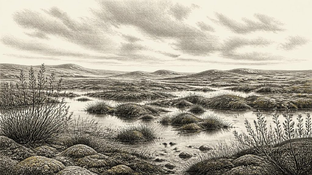
The environment reconstructed from the Derryvree fossils was not woodland, farmland or a settled lakeshore. It was an open, treeless tundra or muskeg landscape, with wet hollows, shallow pools and ground capable of supporting sedges, grasses, mosses and hardy herbs. Finds reported from the deposit include water-milfoil, buckbean, dwarf willow, juniper, clubmoss and mountain-avens, alongside insect evidence consistent with cold, plant-rich wetland conditions. These species and assemblages support an interpretation of brief growing seasons, severe winters and periglacial processes; they do not supply a daily temperature, a fixed snow depth or an unchanging landscape across all Ireland.
For people accustomed to modern Ireland’s dense green cover, the contrast is striking. There is no evidence for an oak forest, enclosed pasture or the rich soils later associated with Irish agriculture. Vegetation would have been patchy and low, varying sharply between damp basins, stream margins, exposed gravelly ground and sheltered slopes. In summer, flowering herbs, mosses and wetland plants could have made these places biologically active. In winter, frost, snow and frozen ground would have imposed a very different regime. Derryvree’s organic silts preserve a landscape of water and tundra rather than a blank, lifeless ice desert.
Ice Growing Across the Island
This was also a time of major regional change. The British–Irish Ice Sheet had not yet reached its later maximum, generally placed around 27,000–21,000 years ago, but ice masses were developing and advancing in the wider Irish and British region. Reviews of Irish glaciation have argued that sub-till organic deposits indicate substantial areas of Ireland remained ice-free until roughly 32,000 years ago, after which the last Irish ice sheet expanded. Exactly how early and how extensively ice occupied particular sectors remains debated, because pre-maximum deposits are scarce and later glaciers repeatedly eroded or buried the evidence.
That uncertainty is historically important. It is unsafe to draw a single ice edge across a modern map and declare all Ireland either habitable or glaciated in 30,462 BCE. Fermanagh’s Derryvree basin was evidently open long enough for freshwater sediments to accumulate. Elsewhere, local ice, snowfields, exposed terrain and coastal waters may have created very different conditions. Sea level was much lower than today, altering the outlines of the Irish Sea basin and connections towards Britain, but a low sea level alone does not demonstrate a usable land route, still less a regular human crossing. The physical geography through which animals or people might have moved was dynamic rather than fixed.
Animals and One Cork Cave
Southern Ireland contributes a separate, powerful body of evidence. Castlepook Cave near Doneraile in north County Cork, long known as Mammoth Cave, has produced Late Pleistocene remains including woolly mammoth, reindeer and spotted hyaena. Older direct dates on a mammoth bone and hyaena bone have been reported at roughly 35,000 and 34,300 radiocarbon years BP respectively. Such cave assemblages show that large grazing animals and formidable carnivores occurred in Ireland during parts of this wider cold-age interval. They cannot, however, be treated as a census of every animal alive at the same moment or as a simple picture of one contemporaneous hunting landscape.
A reindeer femur from Castlepook has attracted exceptional attention because it has been interpreted as bearing a cut made by a sharp stone tool. County Cork’s heritage publication presents it as a Palaeolithic object from about 31,000 BC and attributes the assessment to palaeozoologist Ruth Carden. If the mark is anthropogenic, it may record the butchery or processing of a reindeer by people in Ireland in the broad period under discussion. Its implications are remarkable, but deliberately limited: the bone supplies neither a securely associated hearth nor stone-tool assemblage, dwelling, burial, occupation floor, food store or evidence for continuous settlement.
People: Possibility, Not Population
It would be tempting to turn the Castlepook bone into a story of established Palaeolithic hunters pursuing reindeer across Ireland. The present evidence does not justify that story. At most, it permits the possibility of a short human visit, perhaps involving one animal and a small number of people, in a period when cold-adapted fauna could occupy parts of the island. No human skeletal remains of this antiquity have been recovered in Ireland, and there is no diagnostic Irish toolkit that can responsibly assign any visitors to the Aurignacian, Gravettian or another continental archaeological tradition.
Accordingly, no political affairs, warfare, diplomacy, leadership, territories or formal alliances can be described for Ireland at this date. There is no evidence for villages, houses, permanent camps, kin groups of known size, language, ethnicity, clothing or social rank. Even the basic question of whether people were present at precisely this point remains unanswerable. The responsible distinction is between evidence and interpretation: the reindeer bone may indicate human action; a settled hunting society is an unproven interpretation.
Culture Without a Record
The same restraint applies to religion, art, learning, economy and trade. Ireland has yielded no cave art, carved object, burial rite, shrine, exchange good or identifiable teaching tradition dated to this phase. A possible cut mark is material evidence of practical action, not evidence of belief. Nor does the presence of reindeer, mammoth or hyaena prove that people hunted every species, exchanged hides or travelled along a known route. Continental Upper Palaeolithic communities certainly possessed complex technologies and cultural traditions, but it is not sound to transfer those details automatically to Ireland without an Irish assemblage.
What can be said is more modest and still compelling. Derryvree demonstrates freshwater habitats and plant communities in a cold, open Fermanagh landscape. Castlepook indicates that parts of Cork supported a Pleistocene fauna whose members belonged to wider north-west European ecological networks. Together, they reveal an island repeatedly affected by climate instability and advancing ice, with habitable patches appearing and disappearing on timescales far longer than an individual life but much shorter than geological eras. Later ice and rising seas then destroyed, reworked or submerged much of the evidence that might have clarified human movement.
The Historical Meaning of Silence
For 30,462 BCE, Ireland’s most important story is not one of named people or events but of preservation. Fine silts below Fermanagh tills and old bones in a Cork cave carry fragments of a world otherwise erased by ice, water and time. Their testimony is substantial enough to replace the old image of an entirely empty frozen island with a more varied picture of tundra wetlands, large mammals and possibly fleeting human activity. Yet it is fragmentary enough to demand caution. The year remains a modern coordinate; the evidence belongs to calibrated ranges, landscapes and probabilities.
Primary Sources
- A Middle Midlandian Freshwater Series at Derryvree, Maguiresbridge, County Fermanagh, Northern Ireland
- Irish Pleistocene Biostratigraphy
- The Irish Quaternary Fauna Project
- Pleistocene Glaciations in Ireland
- Figure 6.— The Subdivision of the Quaternary Period in Ireland
- The Derryvree and Maguiresbridge Sections
- The Last Irish Ice Sheet: Extent and Chronology
- Extent and Timing of the Last Glacial Maximum (LGM) in Britain and Ireland: A Review
- Trimlines, Blockfields and the Vertical Extent of the Last Ice Sheet in Southern Ireland
- Deglaciation Chronology of the Donegal Ice Centre, North-West Ireland
- Early Deglaciation of the British-Irish Ice Sheet on the Atlantic Shelf Northwest of Ireland Driven by Glacioisostatic Depression and High Relative Sea Level
- Growth and Retreat of the Last British–Irish Ice Sheet, 31,000 to 15,000 Years Ago: The BRITICE-CHRONO Reconstruction
- The Timing and Magnitude of the British–Irish Ice Sheet Between Marine Isotope Stages 5d and 2
- The Problem of a Late Quaternary Landbridge Between Britain and Ireland
- The IntCal20 Northern Hemisphere Radiocarbon Age Calibration Curve (0–55 cal kBP)
- A Stratigraphic Framework for Abrupt Climatic Changes During the Last Glacial Period Based on Three Synchronized Greenland Ice-Core Records
- Heritage Artefacts of County Cork
- Archaeological Heritage of County Cork
- Castlepook Cave, Co. Cork, 2022 Excavation Report
- Ireland's Palaeolithic Archaeology – Fleeting Footprints in a Frozen Land
- New Insights on the Fauna of Ireland's Younger Dryas and Early Holocene from Alice & Gwendoline Cave
- The Colonization of Ireland: A Human Ecology Perspective
