
Derryvree’s Muskeg Horizon31246 BCE
31,246 BCE is not a recoverable Irish calendar year, but an approximate Late Pleistocene MIS 3 horizon. At Derryvree, County Fermanagh, freshwater organic sediments between glacial tills indicate an ice-free, treeless cold wetland before renewed ice advance. Castlepook Cave, County Cork, preserves reindeer, mammoth, hyaena and other fauna, demonstrating open habitats and broad north-west European ecological connectivity. A cut-marked reindeer femur may indicate human butchery, but its old, insecure context prevents claims for settlement or permanent occupation. Growing British-Irish ice sheets later transformed habitats. Evidence permits environmental reconstruction and cautious possibilities, not political, social or annual history at this depth.
Dateline
The label 31,246 BCE cannot denote a recoverable year in Irish history. No written record, annual chronology, named individual or securely dateable event exists for Ireland at this depth of time. In archaeological terms it corresponds only approximately to 33,200 years before AD 1950, during Marine Isotope Stage 3 (MIS 3), a climatically unstable part of the Late Pleistocene. The relevant evidence is dated in calibrated ranges, often spanning centuries or millennia, and comes from sediments, pollen, plants, insects, animal bones, cave deposits and the landforms left by ice. It can illuminate an interval near this notional year; it cannot tell us what happened in one calendar year.
The best Irish evidence for the broader horizon is therefore environmental. It describes a changing island at the north-western edge of Europe, where cold conditions, shifting ice margins and open habitats governed which animals could live or move through the landscape. Whether people visited is an important but unresolved question. Ireland at this point was not a country with rulers, diplomacy, settlements or recorded conflicts. It was a physical landscape whose history must be assembled cautiously from fragmentary natural archives.
A Wetland Between Ice Sheets
One of Ireland’s most valuable archives lies at Derryvree near Maguiresbridge, County Fermanagh. Roadworks in 1969 cut through a drumlin and exposed fine sands, silts and organic material enclosed between two thick tills: unsorted debris laid down by glacier ice. The discovery was exceptional. Later glaciation has removed or buried much older ground surface across Ireland, but at Derryvree a pocket of freshwater and wetland sediment survived beneath the reshaped drumlin.
The deposit produced radiocarbon determination BIRM-166, conventionally reported as 30,500 ± 1,100 radiocarbon years BP. Such a measurement is not equivalent to a modern calendar date; calibration against changing atmospheric radiocarbon levels produces a broader calendar-age range. Its uncertainty, and the fact that a sediment bed accumulated over time, rule out matching it to 31,246 BCE exactly. Nevertheless, Derryvree is generally assigned to a Middle Midlandian cold phase broadly close to the period under consideration, and it is direct evidence that at least part of Fermanagh was ice-free when the wetland formed.
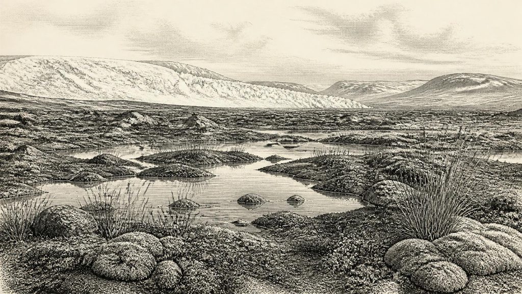
Plants and small organisms recorded in the silts point to a treeless, cold wetland or muskeg rather than a forested Irish countryside. The landscape included shallow or slow-moving freshwater, sedges and moss-rich ground, with low vegetation able to exploit a short growing season. This does not prove that the same conditions extended across the whole island at once. It does show that Ireland was not simply an unchanging white expanse of ice. Local basins could sustain standing water and productive wet ground during intervals when ice had retreated, thinned or had not yet advanced over them.
That local qualification matters. Pollen and plant macrofossils tell archaeologists what entered a particular deposit; their abundance may be influenced by wind, water and preservation. The organic layer offers a carefully bounded environmental reconstruction, not a panoramic map. Yet its existence between tills establishes the larger sequence: a living wetland preceded a renewed glacial advance that sealed it. Ireland’s Late Pleistocene history was made through such alternations, not a single uninterrupted Ice Age.
Animals on the Atlantic Edge
Caves in the Blackwater catchment of north Cork provide a second, very different source of evidence. Castlepook Cave, also called Mammoth Cave, near Doneraile, yielded an extensive collection during antiquarian excavations in the early twentieth century. Its passages received evocative names including Elephant Hall, Wolf Hall and Hyaena Hall, reflecting the extraordinary fossils found there. Direct dating and re-dating have shown that some fauna belong to MIS 3, substantially earlier than older laboratory results had suggested.
The assemblage includes or has included reindeer, woolly mammoth, giant deer, brown bear, wolf, Arctic fox, lemmings and spotted hyaena. These animals should not be imagined as one neatly simultaneous community occupying a single meadow. Cave deposits may combine remains accumulated over long periods. Carnivores can drag bones into dens; water can move sediment and bone; and the old excavations did not meet present-day standards of stratigraphic recording. Direct radiocarbon measurements date individual animals rather than an entire cave layer. Even so, the fauna demonstrates that large mammals and cold-adapted species reached Ireland during the wider pre-Last Glacial Maximum interval.
Reindeer are especially revealing. Their presence implies open country capable of supporting grazing or browsing herds, while mammoth and hyaena indicate that Ireland formed part of a wider north-west European faunal world rather than an isolated modern-style island. The exposed continental shelves and lower sea levels of the Pleistocene altered coastlines profoundly. But fossil animals alone do not reveal the exact route by which any population entered Ireland, or whether dry land, sea ice, short water crossings and temporary corridors mattered most at a particular time. The evidence supports connectivity in the broad ecological sense, not a mapped highway.
The cave record also gives no warrant for confident claims about hunting territories, clan boundaries or a hierarchy of predators and people. Mammals moved according to season, food, shelter and changing terrain. A hyaena den and a human campsite leave very different signatures, but both can result in bones entering a cave. Distinguishing those processes is central to responsible interpretation.
The Reindeer Femur Question
A fragment of reindeer femur from Castlepook has made this interval unusually significant for Irish archaeology. County Cork heritage publications identify it as dating to about 31,000 BCE and record zooarchaeologist Ruth Carden’s interpretation of a deep incision as a mark made by a sharp stone implement during butchery. If that diagnosis is upheld, the bone may be evidence that Upper Palaeolithic people processed a reindeer in Ireland some 20,000 years before the long-established terminal-Pleistocene evidence for human presence.
It is a striking possibility, but its limits are as important as its promise. The femur comes from an old collection, rather than a modern excavation of an intact floor containing a hearth, tools, food waste and dating samples in secure association. A radiocarbon determination dates the animal’s death, not necessarily the cutting event, the place where the animal was killed, or the moment when the bone arrived in the cave. Identifying a surface scar as a stone-tool cut rather than carnivore damage, breakage, trampling or later disturbance is a separate taphonomic judgement.
Accordingly, the femur cannot demonstrate a permanent Irish population, a settlement at Castlepook, a language, ancestry, named archaeological culture or continuous occupation. Nor can it establish that people hunted the animal rather than encountered and processed a carcass. The most that can responsibly be inferred is modest: if the mark is human-made and contemporary with the bone, one or more people used a sharp cutting edge on reindeer in Ireland during this broad cold-stage interval. That would be a momentous extension of the human record, but not a complete social history.
Recent fieldwork has returned to Castlepook precisely because modern excavation, dating and sediment analysis may test old collections more effectively. A 2022 investigation involving researchers from Liverpool John Moores University, University College Dublin and other institutions sought new evidence at the cave. Its importance lies not in confirming a dramatic story in advance, but in improving the context in which the older finds can be assessed.
Ice in Motion
At roughly 33,200 years before present, the British–Irish Ice Sheet was entering a major phase of growth. The latest large-scale BRITICE-CHRONO reconstruction models steady build-up across Ireland and Britain from about 31,000 to 26,000 years ago, before maximum areal extent around 26,000 years ago and maximum volume somewhat later. This does not mean that every Irish district was simultaneously buried at the beginning of that process. Ice-sheet margins advanced unevenly, and local topography, marine basins and changing climate shaped contrasting regional conditions.
Derryvree’s intertill wetland and the Cork cave fauna belong to this larger story of transition. They preserve evidence from intervals before renewed ice cover eliminated many habitats and obscured much of the earlier archaeological landscape. By the Last Glacial Maximum, Ireland was probably almost wholly ice-covered, although the exact distribution of ice, cold-based cover and possible exposed high ground remains debated region by region. The distinction is important: a landscape that was habitable during one MIS 3 interval could become inaccessible or ecologically impoverished later.
The sea was also not a fixed boundary. Global sea level was lower than today because more water was locked in continental ice, but the local shape of coastlines was affected by ice loading and crustal movement as well as ocean level. It is therefore misleading to picture modern Ireland projected unchanged into the Pleistocene. The shorelines, plains and marine passages through which animals—and perhaps people—could move were repeatedly altered.
What Cannot Be Claimed
Political history is absent. There is no evidence for kingdoms, leaders, alliances, warfare, diplomacy, laws or institutions in Ireland around this date. There is likewise no securely documented dwelling, burial, art site, ritual place, textile, boat, hearth or stone-tool assemblage that can be assigned to 31,246 BCE. Religion, language, learning and cultural identity cannot be reconstructed from Derryvree mud or a single modified bone.
Economy and everyday life are similarly beyond direct recovery. If people briefly reached Ireland, they may have been mobile foragers familiar with stone technology and the resources of large mammals; that is an inference from the possible cut mark and wider Upper Palaeolithic comparisons, not an observed Irish settlement pattern. Reindeer could in principle yield meat, marrow, hide, sinew, antler and bone, but Castlepook’s femur does not show which materials were taken or how they were shared. A cave may have been a carnivore den, a natural trap, a place where floodwater accumulated bones, or occasionally a shelter; it need not have been a human home.
The most secure history for this horizon is therefore environmental and evidential. Near the future ice-sheet maximum, Ireland contained changing cold-stage landscapes: freshwater wetlands in Fermanagh during an ice-free interval; open habitats capable of supporting reindeer and other large mammals; and caves in Cork that accumulated a complex record of animals, sediments and perhaps a fleeting human trace. The Derryvree muskeg and Castlepook femur do not give Ireland an annual chronicle. They give it something more scientifically valuable: a disciplined reminder that deep history is built from ranges, contexts and carefully limited conclusions.
Primary Sources
- A Middle Midlandian Freshwater Series at Derryvree, Maguiresbridge, County Fermanagh, Northern Ireland
- A Reconsideration of the Radiocarbon Dating of the Marine Isotope Stage 3 Fauna from Southern Ireland
- The Irish Quaternary Fauna Project
- Growth and Retreat of the Last British–Irish Ice Sheet, 31,000 to 15,000 Years Ago: the BRITICE-CHRONO Reconstruction
- Maximum Extent and Dynamic Behaviour of the Last British–Irish Ice Sheet West of Ireland
- Dimensions and Chronology of the Last Ice Sheet in Western Ireland
- Vertical Dimensions and Age of the Wicklow Mountains Ice Dome, Eastern Ireland, and Implications for the Extent of the Last Irish Ice Sheet
- Radiocarbon Constraints on the Age of the Maximum Advance of the British-Irish Ice Sheet in the Celtic Sea
- Pattern and Timing of Retreat of the Last British-Irish Ice Sheet
- The Colonization of Ireland: A Human Ecology Perspective
- Red Deer in Ireland: Evidence from Fossils, Genetics and Historical Records
- New Insights on the Fauna of Ireland's Younger Dryas and Early Holocene from Alice & Gwendoline Cave
- 2022:564 – Castlepook Cave, Castlepook South, Cork
- Heritage Artefacts of County Cork
- Archaeological Heritage of County Cork
- The Mesolithic in Ireland: When Was It?
- Irish Quaternary Association Field Guide 16: Quaternary of Fermanagh
- Irish Quaternary Association Field Guide 17: The Quaternary of Northern Ireland
- Earth Science Conservation Review: Quaternary Deposits of Northern Ireland
- The Stratigraphic Position and Age of the Gortian
