Derryvree’s Buried Bogbean30997 BCE
Labelled 30,997 BCE, this period cannot be dated annually and is best understood within later Marine Isotope Stage 3, roughly 33,000 years ago. At Derryvree, County Fermanagh, organic sediments beneath glacial till preserve evidence of an open, periglacial wetland, including bogbean, sedges and mountain-avens. They demonstrate a local tundra ecosystem before later ice advance, not island-wide conditions. Ireland’s ice sheet changed regionally and asynchronously. Southern cave deposits record reindeer, mammoth, giant deer and predators in open habitats. A possibly cut-marked Castlepook reindeer bone suggests fleeting human activity, but lacks corroborating settlement evidence. Its history is environmental change, glaciation and fauna.
Dateline
“30,997 BCE” is a modern chronological label, not a year that can be recovered from Ireland’s archaeological record. It corresponds roughly to 32,946 years before AD 1950, the conventional ‘present’ used in radiocarbon dating, but neither people nor events in Ice Age Ireland can be assigned to that calendar year. The responsible frame is the later part of Marine Isotope Stage 3, about 33,000 calendar years ago, when climates, ice margins and animal ranges could change substantially over centuries or millennia. The evidence is therefore environmental and palaeontological rather than historical: layers of mud, pollen, seeds, insect fragments, bones, cave sediments and the changing footprint of ice.
This was not an Ireland of kingdoms, named communities or recorded beliefs. There is no basis for describing politics, diplomacy, warfare, religion, language, art, trade or settlement in the usual historical sense. At most, the period offers a difficult question about whether people ever made very brief visits to the island. The central fact is not a human event but a changing northern landscape, caught between open cold-country habitats and the growth of the British–Irish Ice Sheet.
A Date Without Annual Precision
The difference between calendar years, radiocarbon years and calibrated dates matters especially here. Radiocarbon ages are measured against AD 1950 and must be calibrated because atmospheric carbon-14 has varied through time. At around 30,000 radiocarbon years ago, calibration uncertainties and the shape of the calibration curve make any conversion broad rather than exact. A literal BCE number should consequently be treated as a navigational aid, not as a claim that an Irish deposit formed in one particular winter or summer.
The closest particularly informative Irish environmental record is not exactly contemporary with 30,997 BCE. It comes from Derryvree, near Maguiresbridge in County Fermanagh, where a road cutting through a drumlin exposed organic freshwater silts and fine sands between two thick tills. The conventional radiocarbon determination, BIRM-166, was 30,500 with an uncertainty of about 1,100 radiocarbon years before present. In calendar terms it belongs broadly in the mid-30,000s years ago. That makes it evidence for the general world surrounding this date, rather than a diary entry for the numbered year.
The Wetland Below the Drumlin
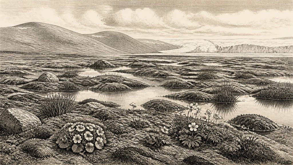
Derryvree is valuable because the buried organic layer preserves a small living landscape. Its plant and animal remains indicated open tundra and a periglacial climate: ground shaped by repeated freezing and thawing, with a short growing season and no closed forest. Mosses, sedges, aquatic plants and cold-adapted herbs grew around freshwater. Among the most memorable finds was a seed of bogbean, Menyanthes trifoliata, a plant of shallow wetlands and marshy margins. Mountain-avens, Dryas octopetala, is also represented by macrofossil evidence. Such remains make the scene more precise than the generic phrase ‘Ice Age’ suggests: not an unbroken white desert, but a treeless mosaic of wet hollows, pools, damp sedge ground, exposed mineral soil and sparse tundra vegetation.
That local precision has limits. Derryvree was a freshwater basin in what is now Fermanagh, not a complete map of the island. Pollen and plant macrofossils show which organisms reached, grew beside or were washed into that basin; they cannot provide a national census of vegetation. Nor does an organic layer trapped between tills prove that every district was ice-free at the same time. Its strongest conclusion is nevertheless important: before later ice overran the area, part of northern Ireland supported a functioning cold-climate wetland ecosystem.
Ice in Motion
Ireland’s ice history at this depth of time is actively researched and remains unevenly dated. Modern reconstructions reject the old picture of a single, static ice sheet simply advancing to one all-island maximum. The British–Irish Ice Sheet grew and retreated asynchronously, with different sectors responding differently to climate, topography and the sea. Around 31,000 years ago, a major synthesis models advancing ice across northern and central Ireland, while acknowledging that direct chronological constraints on much of that advance are sparse. The same work shows that the ice sheet’s maximum extent was not reached everywhere at once; offshore sectors to the north and west behaved differently from those in the Irish Sea.
For the period represented by 30,997 BCE, the safest interpretation is a volatile regional frontier. Ice had existed in the wider Irish–Scottish region earlier in Marine Isotope Stage 3, and substantial ice expansion followed. Yet ice-free refuges or intervals existed in Ireland, as Derryvree’s sediments demonstrate for their own broad date range. A person standing at one site could have encountered frozen ground, meltwater, wind-blown sediment and an open horizon; another site, perhaps not far away in geological terms, could later be buried beneath moving ice. The landforms now familiar as drumlins, till sheets and glacially reshaped valleys were partly products of these repeated advances and reworkings.
Animals of Open Country
Caves in southern Ireland provide a second, complementary archive. Castlepook Cave, also called Mammoth Cave, near Doneraile in north County Cork, has yielded remains belonging to a varied Ice Age fauna. Re-dating of material from Castlepook and other southern caves has shown that some previously accepted dates were too young, placing parts of the fauna much more securely in Marine Isotope Stage 3. Reindeer, woolly mammoth, giant deer, brown bear, wolf, fox, hare, lemmings and spotted hyaena belong to the wider picture assembled from cave deposits and collections.
These animals do not all prove that they lived together in one valley on one day. Cave deposits often accumulate through many episodes: carnivores carry in prey; animals die in caves; water moves bones; excavators working before modern recording standards may mix contexts. Even so, the fauna strongly supports the interpretation of open, cold and ecologically varied country. Reindeer are especially well suited to such terrain. Mammoths and giant deer suggest corridors of grass-rich or herb-rich habitat, while hyaenas indicate large predators and scavengers capable of exploiting the same animal populations. Ireland was not biologically empty, even if human presence remains uncertain.
The Castlepook Human Question
A reindeer femur from Castlepook has been presented as carrying a deep mark consistent with cutting or chopping by a sharp stone tool. Its reported age, around 33,000 years, has made it potentially transformative: if the mark is human-made and contemporary with the fresh bone, it could be evidence that Upper Palaeolithic people processed a reindeer in Ireland far earlier than the long-established post-glacial settlement record.
The claim must be handled carefully. A cut-marked bone would record an action on one carcass, not a village, a permanent population or an Irish cultural tradition. The date of bone collagen establishes when the animal died, not automatically when a surface mark was made. Castlepook’s early excavations also did not recover a securely associated hearth, stone-tool assemblage, dwelling surface, burial or concentration of butchered remains of comparable age. Ireland’s National Museum accordingly continues to state that clear evidence for Palaeolithic human presence has not yet emerged. The careful historical position is that Castlepook offers a serious and intriguing possible trace of human butchery, but not proof of continuous occupation.
Society, Exchange and Belief: What Cannot Be Claimed
If people did reach Ireland at this time, they left no demonstrable settlement plan, named territory, burial rite, symbolic object, artwork or exchange network. No political authority can be inferred. No conflict between human groups is evidenced, and the pursuit or scavenging of animals must not be recast as warfare. Likewise, no evidence supports claims about religion, seasonal ceremonies, kinship systems or learning. The presence of a possible butchered bone could be compatible with a small mobile party using a coastal crossing and exploiting a carcass; it cannot tell us where those people came from, how long they stayed or whether they returned.
Economy, in the human sense, is therefore unknown. Ecology supplies the only secure ‘economy’ visible in the record: plants capturing a short season’s growth; herbivores moving through suitable open habitats; predators and scavengers using carcasses; freshwater organisms inhabiting cold pools. Ice, sea level and the availability of crossing routes shaped the possibilities for all of them. Even with lower global sea levels, Ireland’s separation from Britain remained a major practical boundary for people, while animals could arrive through a mixture of swimming, drifting ice, short sea crossings and changing coastal geography.
An Island of Evidence, Not Certainty
For this point in deep time, Derryvree’s bogbean seed is more historically useful than an invented story of chiefs or hunters. It records life at the edge of severe cold: a wetland plant growing in an open tundra basin before later glaciation sealed the deposit beneath a drumlin. Castlepook’s bones show that large mammals and carnivores used southern Irish landscapes during the wider Marine Isotope Stage 3 interval. The disputed reindeer femur keeps open the possibility of a fleeting human encounter.
Together, these records reveal an Ireland undergoing regional environmental change on a scale beyond any annual chronicle. Around the modern label 30,997 BCE, the island was a fragmented Ice Age world of tundra wetlands, animal movement, advancing ice and sparse surviving evidence. Its most important history is the making, burial and later rediscovery of that landscape.
Primary Sources
- A Middle Midlandian Freshwater Series at Derryvree, Maguiresbridge, County Fermanagh, Northern Ireland
- A Reconsideration of the Radiocarbon Dating of the Marine Isotope Stage 3 Fauna from Southern Ireland
- Growth and Retreat of the Last British–Irish Ice Sheet, 31,000 to 15,000 Years Ago: The BRITICE-CHRONO Reconstruction
- Pattern, Style and Timing of British–Irish Ice Sheet Retreat: Shetland and Northern North Sea Sector
- The Deglaciation of the Western Sector of the Irish Ice Sheet from the Inner Continental Shelf to its Terrestrial Margin
- The Colonization of Ireland: A Human Ecology Perspective
- The IntCal20 Northern Hemisphere Radiocarbon Age Calibration Curve (0–55 cal kBP)
- The IntCal20 Approach to Radiocarbon Calibration Curve Construction: A New Methodology Using Bayesian Splines and Errors-in-Variables
- New Insights on the Fauna of Ireland’s Younger Dryas and Early Holocene from Alice & Gwendoline Cave
- The Irish Quaternary Fauna Project
- Prehistoric Details
- Heritage Artefacts of County Cork
- Menyanthes trifoliata
- Dryas octopetala
- ESCR Site Summary
- Ireland’s Palaeolithic Archaeology – Fleeting Footprints in a Frozen Land
- The Subdivision of the Quaternary Period in Ireland
- Phylogeography, Ancient DNA, and Morphometrics Support the Reintroduction of Red Deer (Cervus elaphus) into Ireland
- The West Corrib Moraine System as Evidence for a Brief Glacial Readvance in Ireland During Overall Heinrich Stadial 1 Deglaciation
- Late Pleistocene Sediments, Landforms and Events in Scotland: A Review of the Terrestrial Stratigraphic Record
