Derryvree’s Permafrost Herbarium30862 BCE
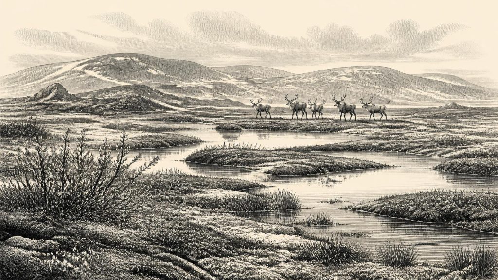
30,862 BCE is only a modern reference point within the climatically unstable Late Pleistocene, not a recoverable Irish year. At Derryvree, County Fermanagh, organic freshwater sediments between glacial tills, radiocarbon dated broadly to MIS 3, preserve evidence of a cold periglacial wetland. Pollen, seeds and animal remains reveal mosses, sedges, bogbean, aquatic plants and sparse tundra vegetation amid freezing soils and changing drainage. Ireland comprised contrasting ice, upland glaciers, open ground and wetlands. Castlepook Cave, County Cork, records MIS 3 mammoth-steppe fauna, including reindeer, giant deer and predators. A cut-marked reindeer bone possibly indicates human activity, but occupation remains unproven.
Dateline
30,862 BCE is a modern calendar label, not a year that can be recovered from Ireland’s prehistoric record. No written calendar, named individual, political event or precisely datable settlement survives from this depth of time. In arithmetic terms it lies roughly 32,812 years before the radiocarbon convention of AD 1950, but that should not be mistaken for a scientific date. Archaeologists and Quaternary scientists work here with deposits, radiocarbon determinations, stratigraphy and calibrated ranges that commonly span centuries or millennia. The responsible question is therefore not ‘what happened in Ireland in this year?’ but what evidence can illuminate the island during the broad interval around it.
That interval belongs to the Late Pleistocene, within Marine Isotope Stage 3: an unstable part of the last Ice Age, marked by sharp climatic shifts well before the Last Glacial Maximum. Ireland was not uniformly entombed beneath ice at every moment. Conditions varied greatly between regions and over long timescales. The most revealing evidence close to this horizon comes from Derryvree near Maguiresbridge in County Fermanagh, where a road cutting exposed an extraordinary buried freshwater deposit inside a drumlin.
A Date Within a Range
In 1969, road works cut through the drumlin at Derryvree and revealed silts and fine sands containing organic material between two distinct sheets of glacial till. The sandwiching tills are crucial: they show that a freshwater environment existed at this spot between phases of glacier activity. A conventional radiocarbon determination from the organic deposit was 30,500 radiocarbon years BP, with a substantial uncertainty of +1,170 and −1,030 years. It is a measurement of an ancient sample, not a timestamp for a single episode.
Calibration converts radiocarbon ages into estimated calendar ages by comparing them with independently dated records. At more than thirty millennia ago, this necessarily produces broad ranges rather than annual precision. The Derryvree deposit is generally assigned to the Middle Midlandian, or middle part of the Irish last-glacial sequence, and belongs broadly to MIS 3. Thus 30,862 BCE can be placed within the environmental world represented by the deposit, but cannot be attached securely to a particular plant, pool, animal or day at Derryvree. The site is a window onto an interval, not a diary.
A Wetland Beneath a Drumlin
The remarkable feature of Derryvree is that it preserves a living landscape rather than merely ice or gravel. Its fossil pollen, plant remains and small animals indicate cold, open country with freshwater habitats. The investigators described a flora and fauna of full-glacial aspect and inferred a periglacial climate: ground subject to repeated freezing and thawing, close to ice-sheet environments but not necessarily beneath glacier ice. The local terrain was probably treeless or almost treeless, exposed to severe winters and short growing seasons.
Yet it was not lifeless. Mosses, sedges and herbaceous plants flourished where shallow water, wet sediment and sheltered hollows permitted. A fossil seed of bogbean (Menyanthes trifoliata) is particularly evocative. Today bogbean is a plant of fens, pools and wet ground; its occurrence at Derryvree demonstrates that freshwater vegetation had found a foothold in the cold landscape. Other macrofossils and pollen point towards low vegetation adapted to damp, open conditions, including plants associated with tundra or arctic-alpine settings. Water-milfoil indicates open water, while dwarf willow, mountain-avens and lesser clubmoss belong to the wider cold-climate assemblage reported from the sequence.
The best reconstruction is not of a modern Irish bog transplanted backwards in time. It is of a fluctuating wetland: shallow pools and sedgy margins, patches of mossy ground, sparse herbs, seasonally frozen soils and exposed mineral surfaces. Organic sediment could accumulate in quieter water, while frost, meltwater and changing drainage repeatedly altered the site. Derryvree’s importance lies in making an apparently empty Ice Age Ireland recognisably ecological. Even during a harsh climatic phase, water and vegetation created local habitats.
An Island of Regional Contrasts
Derryvree should not be used to describe every part of Ireland. The island’s mountains, lowlands, Atlantic margins and interior basins responded differently to climate. Modern reconstructions of the British–Irish Ice Sheet indicate that ice was building across Ireland and Britain during the early thirties of thousands of years before present. By about 31,000 years ago, modelled ice caps and mountain glaciers occupied substantial upland areas of Ireland, including northern and north-western highlands, while glaciers and ice fields also existed in several other mountain districts. The great expansion towards the ice sheet’s maximum came later, principally between about 31,000 and 23,000 years ago.
This wider setting helps explain Derryvree’s layered structure. The freshwater bed records an interval in which its locality supported wetland life; the tills above and below record glacial episodes before and after it. It does not prove that all Ireland was green, ice-free or hospitable at once. Rather, it warns against simple maps of an entirely frozen island or an entirely open one. Ireland around this notional date was a changing mosaic of ice, periglacial ground, cold wetlands and animal habitat, its coastlines also altered by lower global sea levels.
The Southern Cave Record
County Cork provides a complementary, if more complicated, record. Castlepook Cave near Doneraile, once popularly called Mammoth Cave, contains Ireland’s richest known assemblage of pre-Last Glacial Maximum mammals. Its old excavations yielded remains of mammoth, giant deer, reindeer, brown bear, wolf, Arctic fox, lemmings and spotted hyaena. These animals indicate that southern Ireland was connected ecologically to the wider north-west European mammoth-steppe and tundra world at various points during MIS 3.
However, Castlepook is not a single frozen moment. Animals may have died near fissures, been dragged in by carnivores, been washed or reworked by water, or entered deposits separated by thousands of years. Improved radiocarbon pretreatment has shown that several older Irish cave dates were misleadingly young; renewed work at Castlepook moved some specimens back by roughly 5,000 to 12,000 radiocarbon years and confirmed the importance of MIS 3 fauna. It would nevertheless be wrong to assemble every species recovered there into one herd roaming past the cave in 30,862 BCE.
The cave does support a broad picture of food webs beyond Derryvree’s wetland. Reindeer and giant deer were herbivores of open country; wolves and spotted hyaenas were major carnivores and scavengers; Arctic foxes and lemmings signal cold conditions. Mammoth remains make the record especially striking, but they must be treated as evidence of occurrence within a lengthy faunal history, not proof that mammoths stood at any particular Irish location on the numbered year in question. Faunal deposits establish presence and environment more securely than population sizes, migration routes or exact seasonal behaviour.
A Possible Human Trace
Castlepook also raises the tantalising question of people. A reindeer femur in the National Museum of Ireland’s Natural History collection has been identified by zooarchaeologist Ruth Carden as bearing a deep mark consistent with cutting or chopping fresh bone with a sharp stone tool. County Cork heritage material assigns the object broadly to about 31,000 BC. If that interpretation and association are sustained, it may represent the earliest claimed evidence of human handling of an animal in Ireland, and it is directly relevant to the wide chronological horizon surrounding 30,862 BCE.
Its limitations are as important as its promise. One marked bone is not a camp, village or settled population. Castlepook has yielded no securely associated stone-tool assemblage, hearth, dwelling surface, human burial or extensive food-processing deposit of this age. Nor can the bone tell us whether people killed the reindeer, found a carcass, butchered it near the cave, visited briefly or returned repeatedly. A radiocarbon date on bone measures the animal’s death; it does not automatically date the mark, still less establish the duration of human presence. The cautious conclusion is that Upper Palaeolithic carcass processing in Ireland is possible, not that a documented community occupied the island in this particular year.
No Politics, But a Human World Beyond Ireland
There is no evidence from Ireland for political affairs, diplomacy, named groups, religious observance, formal learning, trade networks or social hierarchy at this date. There are no Irish houses, graves, artworks, tools or monuments securely attributable to the Derryvree horizon. Silence on these subjects is not a failure of imagination; it is the proper consequence of the evidence. If people did reach Ireland during MIS 3, they would have belonged to the wider Upper Palaeolithic world of mobile hunter-gatherers known elsewhere in Europe, but Irish material presently cannot demonstrate their language, beliefs, kinship systems or routes of travel.
Nor should animal presence be converted automatically into an economy. The Derryvree wetland was an ecological system, not evidence of farming, herding or trade. The possible Castlepook cut mark may indicate a moment of meat and marrow processing with a stone edge, but it cannot reveal ownership, exchange or a settled subsistence strategy. The only responsible social history is a narrow one: very small numbers of highly mobile people may have entered an exceptionally demanding landscape, while the evidence for sustained occupation remains unproven.
What Derryvree Preserves
The central historical fact around 30,862 BCE is environmental resilience amid climatic instability. Under a later-built drumlin, Derryvree retained traces of freshwater life: mosses, sedges, aquatic plants and other small witnesses to a cold wetland between ice advances. Castlepook, far to the south, preserves a longer and more mixed record of Ice Age fauna, plus a possible sign of human intervention. Together they replace the old image of a wholly blank Palaeolithic Ireland with something both richer and more disciplined: a landscape that was inhabited by plants and animals, perhaps occasionally visited by people, but still beyond the reach of year-by-year narrative.
That is why modern calendar precision must be resisted. 30,862 BCE is useful as a point of orientation for readers, but the evidence speaks in ranges, layers and probabilities. At Derryvree, it speaks most clearly of cold freshwater, sparse tundra vegetation and a landscape repeatedly transformed by ice.
Primary Sources
- A Middle Midlandian Freshwater Series at Derryvree, Maguiresbridge, County Fermanagh, Northern Ireland
- Palaeoecology: IQUA Field Guide 16
- A Reconsideration of the Radiocarbon Dating of the Marine Isotope Stage 3 Fauna from Southern Ireland
- The Irish Quaternary Fauna Project
- Growth and Retreat of the Last British–Irish Ice Sheet, 31,000 to 15,000 Years Ago: the BRITICE-CHRONO Reconstruction
- The Timing and Magnitude of the British–Irish Ice Sheet Between Marine Isotope Stages 5d and 2: Implications for Glacio-Isostatic Adjustment, High Relative Sea Levels and ‘Giant Erratic’ Emplacement
- Maximum Extent and Dynamic Behaviour of the Last British–Irish Ice Sheet West of Ireland
- Radiocarbon Constraints on the Age of the Maximum Advance of the British–Irish Ice Sheet in the Celtic Sea
- Stratigraphic and Palaeo-Geomorphological Evidence for the Glacial-Deglacial History of the Last British-Irish Ice Sheet in the North-Western Irish Sea
- First Evidence of a Late Upper Palaeolithic Human Presence in Ireland
- New Insights on the Fauna of Ireland's Younger Dryas and Early Holocene from Alice & Gwendoline Cave
- Heritage Artefacts of County Cork
- Menyanthes trifoliata
- Irish Vegetation Classification: Fens, Mires and Springs
- Ireland: Submerged Prehistoric Sites and Landscapes
- BRITICE Glacial Map, Version 2: a Map and GIS Database of Glacial Landforms of the Last British–Irish Ice Sheet
- Trimlines, Blockfields and the Vertical Extent of the Last Ice Sheet in Southern Ireland
- Exploring Controls of the Early and Stepped Deglaciation on the Western Margin of the British Irish Ice Sheet
- The IntCal20 Northern Hemisphere Radiocarbon Age Calibration Curve (0–55 cal kBP)
- Advice to the Public on the Archaeological Potential of Caves
