

Fermanagh’s Trifoliate Flora30863 BCE
Labelled 30,863 BCE, this uncertain Late Pleistocene horizon falls within MIS 3, not a precisely recoverable Irish year. At Derryvree, Fermanagh, freshwater sediments between glacial tills record a local ice-free interval, dated to 36,900–31,700 years before present. Macrofossils and insects indicate cold, treeless, waterlogged tundra with sedges, mosses, bogbean, low shrubs and herbs, later buried by renewed ice. Castlepook Cave, Cork, preserves a mixed-age fauna including mammoth, reindeer, giant deer, predators and lemmings, showing productive open habitats. A possibly cut-marked reindeer bone suggests, but cannot prove, brief human contact; secure evidence is later. No societies or beliefs can be reconstructed.
Dateline
30,863 BCE is a modern chronological label, not a date that can be matched to an event, season, ruler or community in Ireland. It falls roughly 32,800 calendar years before AD 1950, within the Late Pleistocene, during Marine Isotope Stage 3 (MIS 3), a long and climatically unstable part of the last glacial cycle. At this depth of time, modern calendar-year precision is unavailable. Radiocarbon dates must be calibrated, and even calibrated results produce probability ranges rather than a dependable account of one numbered year. The responsible history of Ireland at this point is therefore an environmental and archaeological reconstruction: a story of ice, thaw, water, plants, animals and a still-unsettled possibility of brief human contact.
A Date Within a Broad Interval
The closest major Irish palaeoenvironmental evidence comes from Derryvree, near Maguiresbridge in County Fermanagh. Road construction in 1969 cut through a drumlin and revealed freshwater silts and fine sands sealed between two layers of glacial till. Till is the unsorted debris left directly by moving ice. The order of deposits matters: an earlier glacier laid down the lower till; freshwater sediments accumulated during a subsequent local ice-free interval; and ice later returned, depositing the upper till. Derryvree is not a record of one day, one year or the whole island. It is, however, unusually valuable evidence that conditions in this part of Fermanagh changed sharply during the late Ice Age.
Organic material from the freshwater bed gave a conventional radiocarbon age of 30,500 radiocarbon years before present, with a substantial uncertainty. Modern calibration places the formation of the deposit broadly in a late-MIS-3 range, approximately 36,900–31,700 calibrated years before present. The nominal year 30,863 BCE, about 32,800 calibrated years before present, lies within that broad horizon. It should not be treated as proof that every plant fossil from Derryvree grew in that particular year, or that identical conditions prevailed from Cork to Donegal. Its value is chronological context: this was an interval before the fullest expansion of the last Irish ice sheet, when some places could sustain exposed, wet, cold landscapes.
Wet Ground Beneath the Drumlin
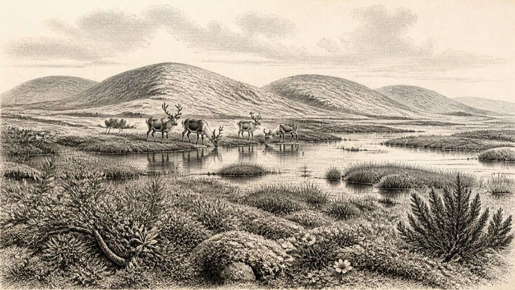
Derryvree’s plant and animal remains indicate treeless tundra-like vegetation and a periglacial climate: a climate in which frost, seasonal thaw and frozen ground strongly shaped the landscape, even where glacier ice was absent. The scene was not the familiar green, wooded Ireland of later millennia. Pollen was poorly preserved, but plant macrofossils, mosses and insects supply a more detailed local picture. Sedges, grasses and herb-rich vegetation occurred alongside mosses suited to wet ground. Finds identified from the deposit include bogbean (Menyanthes trifoliata), water-milfoil, mountain-avens, dwarf willow, juniper and lesser clubmoss.
That assemblage implies a mosaic rather than a uniform plain. Shallow freshwater pools and their margins supported aquatic plants; saturated ground carried sedges and mosses; more exposed patches could sustain low shrubs and cold-adapted herbs. Mountain-avens, for example, is associated with open, base-rich and often cold environments. Bogbean points to still or slow-moving freshwater. Such evidence supports the interpretation of a muskeg-like wetland: waterlogged, organic-rich terrain broken by pools, frost-affected ground and sparse vegetation. It does not license a precise weather report, but it makes clear that Fermanagh was not continuously buried beneath an unbroken ice sheet throughout the period represented.
The sedimentary sequence also records vulnerability. The upper till shows that this relatively open freshwater environment was eventually overridden or buried by renewed glaciation. Later ice and meltwater repeatedly eroded, transported and concealed older surfaces across Ireland. That destruction helps explain why so little survives of the island’s early human and animal history. Derryvree is exceptional not because it represents all of Ireland, but because a brief environmental archive endured beneath a drumlin where most comparable landscapes were removed or transformed.
Animals in a Changing Landscape
At the other end of the island, Castlepook Cave near Doneraile in north County Cork preserves Ireland’s richest known assemblage of vertebrate remains dating to the period before the Last Glacial Maximum. Its caves contain bones attributed to woolly mammoth, giant deer, reindeer, brown bear, wolf, Arctic fox, mountain hare, collared and Norwegian lemmings, and spotted hyaena. These are compelling signs that late-Pleistocene Ireland periodically supported a far more varied fauna than the island’s historic landscape.
Yet Castlepook must be used carefully. Its bones accumulated in a complex cave system over long spans of time, were moved by water and carnivores, and were excavated largely in the early twentieth century, before modern standards of stratigraphic recording. Some remains are demonstrably of different ages; later deposits and disturbance complicate the collection further. A cave inventory is not a photograph of a single season. It would be wrong to imagine every listed species standing together outside the cave in 30,863 BCE.
Nonetheless, the fauna establishes a broad ecological setting. Reindeer and lemmings indicate cold, open habitats. Mammoth and giant deer show that Ireland could at intervals sustain large herbivores, while wolves, Arctic foxes and spotted hyaenas occupied higher positions in the food web or scavenged carcasses. Hyaenas may themselves have contributed to the accumulation and modification of bones in Castlepook. The presence of both large grazers and predators is evidence for episodically productive landscapes, not for an easy or stable environment. Food supplies, snow cover, frozen ground, water availability and ice margins would all have changed across seasons and longer climatic oscillations.
The wider North Atlantic setting was similarly dynamic. MIS 3 contained abrupt climatic shifts on millennial scales. Ice masses around Ireland did not simply advance in one uninterrupted movement towards their later maximum. The most extensive last glacial ice cover came thousands of years after the Derryvree interval, with reconstructions placing its maximum extent broadly around 27,000–23,000 calibrated years before present. Around 32,800 years ago, Ireland was instead a shifting regional mosaic in which local ice, exposed ground, wetlands, caves and changing coasts could coexist at different places and times.
The Human Question at Castlepook
The most provocative evidence relevant to this date is a reindeer femur from Castlepook reported to bear a deep mark consistent with cutting or chopping by a sharp stone implement while the bone was fresh. The animal bone has been presented as dating to about 33,000 years ago, placing it broadly near the horizon represented by 30,863 BCE. If the mark is confirmed as human-made and contemporary with the animal’s death, it would indicate that one or more Upper Palaeolithic people handled a reindeer carcass in Ireland remarkably early.
That conclusion remains necessarily narrow. A modified bone is not a settlement. No securely associated hearth, stone-tool assemblage, dwelling floor, burial, human bone, art object or occupation surface has established a resident Irish community of this age. The femur derives from an old cave collection with difficult stratigraphic context, and the interpretation of a surface mark is separate from the radiocarbon age of the animal. Carnivore activity, sediment abrasion, breakage and excavation damage all require close assessment when identifying possible butchery marks.
It is therefore responsible to describe early human presence as possible, perhaps even plausible, rather than settled fact. A short incursion by mobile hunters could explain a butchered bone; so could a more complicated sequence in which a processed carcass or bone was later moved by animals or water. Neither explanation demonstrates a permanent population, a regular migration route, boats, a land crossing, or descent from these people to later inhabitants. The first securely published evidence for human activity in Ireland remains much later: cut marks on a brown-bear patella from Alice and Gwendoline Cave in County Clare, dated to roughly 12,810–12,590 calibrated years before present.
No Polities, No Recorded Beliefs
There is no evidence from Ireland around this horizon for political affairs in the later sense: no named peoples, rulers, territories, diplomacy, warfare, law or institutions can be reconstructed. Nor can archaeology responsibly identify social rank, kinship systems, language or ethnic identity. If people briefly reached the island, calling them ‘Irish’ would impose a modern national category on an era tens of millennia before Ireland possessed such identities.
The same restraint applies to religion, culture and learning. Elsewhere in Upper Palaeolithic Europe, people made sophisticated stone tools, ornaments, images and burial deposits. Those wider achievements establish what human societies could do, but they are not evidence that equivalent practices occurred in Ireland. Castlepook has not yielded securely dated Irish cave art, portable art, ritual deposits or monuments from this period. There is likewise no direct evidence for trade. The movement of animals and perhaps people between Ireland and neighbouring regions is an inference from geography and fauna, not documentation of exchange networks.
What Everyday Life Can—and Cannot—Mean
If humans were present, their everyday life can only be approached through cautious comparison with mobile Upper Palaeolithic hunter-gatherers elsewhere in north-west Europe. Reindeer could provide meat, fat, hide, sinew, bone and antler; a cold open landscape also offered birds, small mammals and plant resources in season. But these are possibilities based on the animal world, not observations of an excavated camp. No Irish evidence tells us how many people travelled together, where they sheltered, how long they stayed, or whether they returned.
The stronger history is the landscape’s. Around this notional date, Fermanagh’s buried freshwater bed records a cold, open wetland alive with sedges, mosses and trifoliate bogbean; Castlepook preserves traces of large herbivores and formidable scavengers or predators in southern limestone country. Between those records lies a changing island repeatedly altered by ice. The crucial development was not a battle, kingdom or invention, but the unstable coexistence of thawed habitats and advancing glacial systems. It created opportunities for plants and animals—and possibly fleeting human visitors—while also ensuring that much of their evidence would later be erased.
Primary Sources
- A Middle Midlandian Freshwater Series at Derryvree, Maguiresbridge, County Fermanagh, Northern Ireland
- Palaeoecology
- Figure 6.— The Subdivision of the Quaternary Period in Ireland
- Castlepook Cave: County Geological Site Report
- A Reconsideration of the Radiocarbon Dating of the Marine Isotope Stage 3 Fauna from Southern Ireland
- The Irish Quaternary Fauna Project
- The Exploration of Castlepook Cave, County Cork
- The Mammoth Caves of Castlepook, Near Doneraile
- Occurrence of Mammalia Relicts at Site Castlepook Cave
- Archaeology Research Excavation Grant 2022: Castlepook Cave
- Heritage Artefacts of County Cork
- Archaeological Heritage of County Cork
- The IntCal20 Northern Hemisphere Radiocarbon Age Calibration Curve (0–55 kcal BP)
- IntCal: International Radiocarbon Calibration
- Dimensions and Chronology of the Last Ice Sheet in Western Ireland
- Response of the Irish Ice Sheet to Abrupt Climate Change During the Last Deglaciation
- Last Glacial Maximum Cirque Glaciation in Ireland and Implications for Reconstructions of the Irish Ice Sheet
- Ireland: Submerged Prehistoric Sites and Landscapes
- First Evidence of a Late Upper Palaeolithic Human Presence in Ireland
- New Insights on the Fauna of Ireland's Younger Dryas and Early Holocene from Alice & Gwendoline Cave