Mammoth Cave’s Reindeer Passage31821 BCE
31,821 BCE falls within Ireland’s later Marine Isotope Stage 3, a cold, unstable Pleistocene period known only through sparse environmental and faunal evidence. Castlepook Cave, north Cork, yielded a reindeer femur possibly cut by a stone tool, suggesting brief human carcass processing but not settlement. Derryvree deposits in Fermanagh indicate open, treeless tundra conditions, while Castlepook fauna included reindeer, mammoth, predators and lemmings. Dating remains broad and uncertain, and cave deposits are disturbed. Possible visitors were mobile Upper Palaeolithic hunter-gatherers, though no camps, tools or human remains survive. Changing sea, ice and land routes shaped access before glaciation obscured evidence.
Dateline
“31,821 BCE” is a modern way of labelling a point unimaginably far beyond written history, not a date that anyone living in Ireland could have recognised. Calendar-year precision is not available for this period. The responsible approach is to place the notional year within a broad later Marine Isotope Stage 3 (MIS 3) setting, using radiocarbon dates calibrated into calendar ranges where possible. Around this point, Ireland was in the Pleistocene, well before the Last Glacial Maximum, and its human history is represented not by chronicles, settlements or named peoples, but by a very small and difficult body of environmental and faunal evidence.
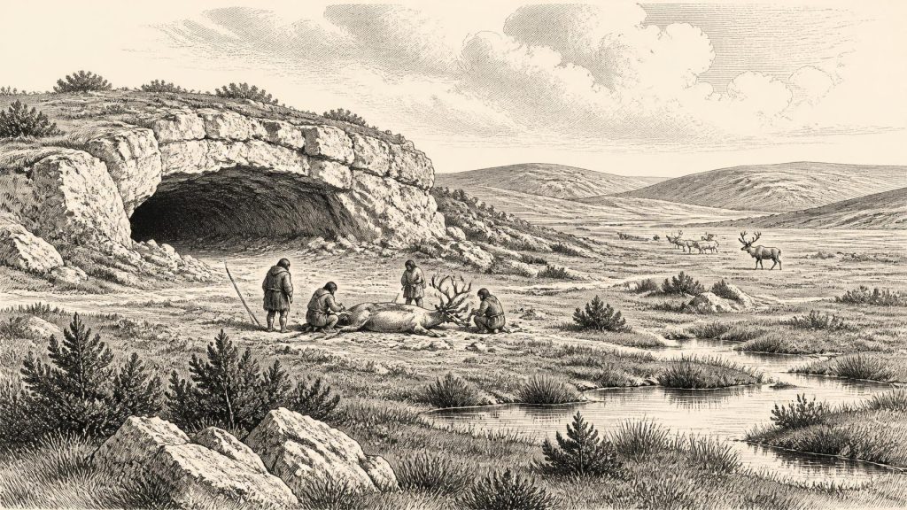
That evidence nonetheless changes the old picture of an empty Ice-Age island. In north Cork, Castlepook Cave—also called Mammoth Cave or Doneraile Cave—has produced bones of a striking cold-climate fauna. A reindeer femur from the cave has been identified as bearing a mark interpreted as having been made by a sharp stone implement during carcass processing. County Cork’s heritage catalogue presents the specimen as dating to about 31,000 BC. If that interpretation is sustained, it is evidence for a human visit or short episode of activity, rather than proof of a permanent population. No securely associated stone toolkit, hearth, dwelling, human bone or occupation surface has yet been recovered.
Dating A Deep Past
The apparent precision of 31,821 BCE must therefore not be mistaken for a precise archaeological moment. Radiocarbon determinations measure radiocarbon years before present, conventionally before 1950, and must be calibrated against changing atmospheric carbon levels to create calendar-age estimates. At great age the calibrated intervals can be wide, and old cave collections introduce further problems: bones may have been moved by animals, water, earlier excavation or later disturbance; material from different episodes can lie close together; and improved preparation techniques have revised some earlier Irish results substantially. The current IntCal20 calibration curve is especially important for the last glacial period, where revisions can alter calendar placement materially.
A useful northern Irish comparator comes from Derryvree, near Maguiresbridge in County Fermanagh. There, organic freshwater silts and fine sands were discovered between two distinct sheets of glacial till. Their original radiocarbon determination was 30,500 radiocarbon years BP, with a sizeable uncertainty. Published calibrated discussion places the deposit broadly at roughly 36,900–31,700 calendar years BP—approximately 34,950–29,750 BCE. The range embraces 31,821 BCE, but it does not establish conditions on that particular year. It provides a regional environmental window, not an annual record.
An Open, Cold Country
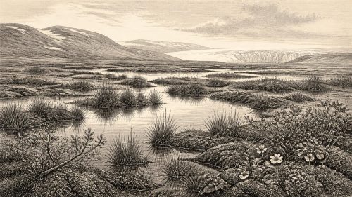
Derryvree’s pollen, plant remains, mosses and animal evidence indicate an open tundra environment under periglacial conditions. Grass and sedge communities, herbs, juniper and mosses belonged to a treeless landscape in which wet ground, shallow pools and seasonally frozen soils mattered as much as broad expanses of exposed mineral earth. It was not a featureless white wilderness throughout the year. In a brief summer, plants could flower, insects could breed and grazing animals could exploit fresh growth; in winter, cold, wind and snow imposed severe limits. The exact balance varied from region to region and from one climatic oscillation to another, so Fermanagh should not simply be projected unchanged onto Cork. It does, however, show that parts of Ireland supported open habitats before later ice expansion.
At Castlepook in the Awbeg Valley, the cave assemblage records animals suited to very different positions in an Ice-Age food web. Reindeer, woolly mammoth, giant deer, brown bear, wolf, fox, Arctic fox, spotted hyaena and lemmings have all been reported from the wider pre-Last Glacial Maximum assemblage, though not all specimens are necessarily contemporary. The crucial point is not that all these creatures stood together on one day in 31,821 BCE, but that southern Ireland supported, across a long MIS 3 interval, a fauna far richer and colder-adapted than that of the modern island. Reindeer and mammoth imply grazed open ground; lemmings are consistent with tundra-like habitats; hyaenas, wolves and bears reveal the hazards and scavenging opportunities around animal carcasses.
What The Cave May Preserve
The Castlepook reindeer bone is important precisely because it is so modest. One possible cut mark does not furnish a dramatic hunting scene. It may indicate that people used a sharp flaked-stone edge to remove meat, tendon or hide from a carcass. The animal could have been hunted, found already dead, or obtained after another predator had killed it; the cave itself may have been a carnivore den rather than a human camp. Cork County Council’s interpretation is that the animal was probably processed elsewhere and that remains were later scavenged or dragged into the cave by hyaenas or wolves. This is plausible inference, not demonstrated sequence.
Even identification of ancient activity demands caution. Marks on bone can be made or altered by tooth action, trampling, sediment movement and excavation damage. Equally, a historic cave collection does not preserve the original positions of all finds with modern standards of recording. Recent work at Castlepook has sought surviving Pleistocene deposits in areas overlooked or inaccessible to twentieth-century excavators. It located sediments and zones of potential, but also encountered redeposited spoil, modern disturbance and the consequences of earlier digging. This is why the most defensible conclusion is deliberately narrow: the bone offers potential evidence for Palaeolithic people in Ireland, while the character, duration and scale of their presence remain unknown.
People Without Polities
There is no evidence for political institutions, rulers, territories, diplomacy or organised warfare in Ireland at this date. There are no names, languages, monuments, burials or artistic traditions that can be assigned to the possible visitors. It would be wrong to supply them from later Celtic, medieval or even Mesolithic Ireland. The relevant comparison is instead with Upper Palaeolithic hunter-gatherers elsewhere in north-west Europe: highly mobile small groups, able to make sophisticated stone tools, read animal behaviour and cope with dangerous seasonal environments. That comparison can suggest possibilities; it cannot turn Castlepook’s lone modified bone into proof that a particular community lived in the Awbeg Valley.
If people did enter Ireland during this warmer interval before the ice maximum, everyday survival would have centred on movement, fuel, shelter, clothing and food. A carcass represented meat, marrow, fat, hide, sinew and bone: resources whose value rose in cold, sparsely wooded landscapes. Reindeer were especially mobile grazers, and following their routes may have been more realistic than establishing fixed settlements. Yet Ireland has not yielded the lithic scatters, repeated hearths or durable camp remains needed to demonstrate a seasonal round. “Economy” can therefore mean only immediate subsistence and resource use, not agriculture, pastoralism, market exchange or trade.
Routes, Ice And Separation
Ireland’s relation to neighbouring lands was also not the modern one. Global sea level was lower during the glacial world, but a simple dry land bridge across the Irish Sea should not be assumed. Research on late-Quaternary palaeogeography has questioned such a route, while later studies emphasise shifting ice, sea and coastal configurations rather than a single stable connection. Animals and any human groups could have reached Ireland through changing northern or western corridors, across ice-linked terrain, narrow-water crossings or a mixture of these. The Castlepook fauna establishes that large mammals did reach the island in this broad period; it does not reveal the route followed by one reindeer, still less by a human party.
Climate was moving towards a more formidable phase. The British–Irish Ice Sheet was expanding during the latter part of MIS 3, with reconstructions showing major advance by about 31,000 years ago and eventual maximum extent later, around 26,000 years ago in the wider ice-sheet system. Such broad chronologies should not be read as a statement that all Ireland was overwhelmed simultaneously. Ice margins, outlet glaciers, uplands and lowlands changed asynchronously. But the long-term trend was one of worsening prospects for people and animals dependent on accessible open ground. Subsequent glaciation also helps explain why traces of any early visitors may have been eroded, buried offshore, or survive only in protected caves.
A Record Of Absence
Religion, formal learning and cultural expression cannot responsibly be described for Ireland in 31,821 BCE. There is no Irish cave art, symbolic object or structured deposit securely attributable to this horizon. Nor is there evidence for regular exchange with Britain or continental Europe. Absence is not proof that people possessed no beliefs, skills or social bonds; all human communities do. It means that Ireland’s surviving record is too thin to identify their forms. The meaningful historical development is the emergence of a cautious possibility: during a cold but habitable interlude, human beings may have reached the western edge of Europe and processed an animal in what is now north Cork.
For Ireland, then, this is not a year of kings, battles or foundations. It is a year best approached through a reindeer bone, tundra silts, cave sediments and the advancing shadow of ice. These remain fragments, but they are consequential fragments. They place the Irish past within the deep Palaeolithic world of climatic instability, mobile fauna and perhaps fleeting human passage—tens of millennia before the better-attested hunter-gatherer settlement of the early Holocene.
Primary Sources
- A reconsideration of the radiocarbon dating of the Marine Isotope Stage 3 fauna from southern Ireland
- The Irish quaternary fauna project
- Middle Midlandian Freshwater Series at Derryvree, Maguiresbridge, County Fermanagh, Northern Ireland
- Growth and retreat of the last British–Irish Ice Sheet, 31 000 to 15 000 years ago: the BRITICE-CHRONO reconstruction
- Extent and timing of the Last Glacial Maximum (LGM) in Britain and Ireland: a review
- Character of advance and retreat of the southwest sector of the British-Irish Ice Sheet during the last glaciation
- The problem of a late quaternary landbridge between Britain and Ireland
- Trimlines, blockfields and the vertical extent of the last ice sheet in southern Ireland
- Early deglaciation of the British-Irish Ice Sheet on the Atlantic shelf northwest of Ireland driven by glacioisostatic depression and high relative sea level
- New data for the Last Glacial Maximum in Great Britain and Ireland
- New insights on the fauna of Ireland's Younger Dryas and Early Holocene from Alice & Gwendoline Cave
- Phylogeographic, ancient DNA, fossil and morphometric analyses reveal ancient and modern introductions of a large mammal: the complex case of red deer (Cervus elaphus) in Ireland
- The IntCal20 Northern Hemisphere radiocarbon age calibration curve (0–55 cal kBP)
- The IntCal20 approach to radiocarbon calibration curve construction: a new methodology using Bayesian splines and errors-in-variables
- Heritage Artefacts of County Cork
- The Archaeological Heritage of County Cork
- 2022:564 – Castlepook Cave, Castlepook South, Cork
- The Last Glacial Maximum British-Irish ice sheet: a reconstruction using digital terrain mapping
- Oscillating retreat of the last British-Irish Ice Sheet on the continental shelf offshore Galway Bay, western Ireland
- A 10Be-dated record of glacial retreat in Connemara, Ireland, following the Last Glacial Maximum and implications for regional climate