

Maguirebridge’s Periglacial Reedbed31769 BCE
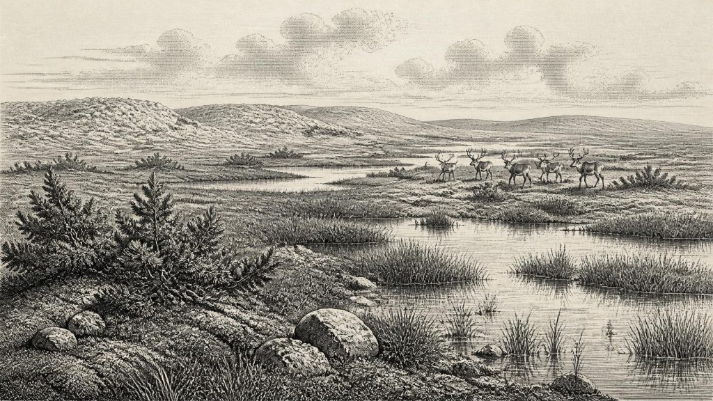
Around 31,769 BCE, Ireland lay within the climatically unstable Marine Isotope Stage 3. Derryvree, County Fermanagh, preserves freshwater silts between glacial tills, showing locally ice-free, treeless, frost-bound wetlands with sedges, grasses, mosses and juniper. Castlepook Cave, County Cork, contains MIS 3 remains of mammoth, reindeer, giant deer, hyaena and other animals, demonstrating ecologically varied cold-stage habitats. A modified reindeer bone may indicate an early human visit, but remains inconclusive without securely associated tools or occupation evidence. Later ice expansion damaged and buried much evidence. The period is therefore reconstructed from fragmentary environmental and faunal archives, not precise events or communities.
Dateline
The label 31,769 BCE is a modern chronological convenience, not a date that can be recovered from Ireland’s evidence with calendar-year precision. There were no written records, rulers, settlements with annual sequences, or artefacts securely dated to that individual year. Converted to the archaeological convention of years before AD 1950, it falls about 33,718 calibrated years before present (cal BP), within Marine Isotope Stage 3 (MIS 3), an unstable interval of the last Ice Age. The responsible history of Ireland at this depth of time is therefore one of broad, calibrated ranges, fossil deposits and changing landscapes—not a narrative of a particular year.
A Date Within a Wider Window
Radiocarbon results are not calendar dates read straight from a bone or layer of silt. They measure remaining radioactive carbon and must be calibrated against a curve built from independently dated environmental archives. Beyond 30,000 years ago, the relation between radiocarbon years and calendar years is especially uneven, so errors and ranges matter greatly. The important local chronological anchor is a freshwater deposit exposed at Derryvree, near Maguiresbridge in County Fermanagh. Organic silts and fine sands trapped between two sheets of glacial till produced a radiocarbon determination of 30,500+1170−1030 radiocarbon years BP. With modern calibration, that determination spans broadly about 36,900–31,700 cal BP. Thus 31,769 BCE lies close to the younger edge of a dated environmental window, rather than at a point archaeology can isolate.
That distinction is more than technical. A deposit may have accumulated over many years or centuries; a dated animal bone records the death of that animal, not necessarily the moment when it entered a cave. Old excavations, later movement by water or animals, and the reworking of sediment can further complicate the story. The date can responsibly be used to ask what parts of Ireland were like during a late MIS 3 interval. It cannot identify a named community, a hunt in a particular season, or an event on a particular day.
Derryvree Between the Tills
Derryvree is exceptionally valuable because its silts survived between later glacial deposits. The fossil plants, mosses and insects found there point to open, treeless vegetation under a periglacial climate: ground subject to severe frost, short growing seasons and long cold winters. Grasses, sedges, herbs and juniper occur in the botanical record. The insect evidence, together with abundant mosses and the structure of the sediments, indicates wet ground with pools and plant-rich margins: a cold muskeg or sedge marsh rather than a forest or a permanently frozen white desert.
This was a living landscape, but a spare one. In summer, shallow water, reeds and sedges could have made small habitats productive for insects, birds and grazing animals. In winter, frost action, snow cover and exposed winds would have constrained both vegetation and movement. Juniper is particularly revealing. Its presence does not mean that a modern scrubland stretched across Ulster; it shows that hardy woody plants could survive locally amid predominantly open ground. Derryvree, however, is a record from one inland basin. It cannot be assumed to represent every Irish coast, upland or valley at the same time.
The interval also demonstrates a crucial geological fact: at least parts of north-central Ireland were ice-free when the organic layers formed. The lower till beneath the deposit records an earlier ice advance; the upper till records a later one. In between lay a period when freshwater sediments, plants and animals occupied the site. This does not prove that all Ireland was free of ice at 31,769 BCE. It instead gives firm local evidence for an ice-free environmental episode before the island was overwhelmed during the later maximum expansion of the British–Irish Ice Sheet.
An Island of Abrupt Change
MIS 3, conventionally extending from roughly 60,000 to 30,000 years ago, was not one unchanging climate. Greenland ice cores, European cave records and North Atlantic marine archives show repeated, abrupt swings between colder stadials and relatively milder interstadials. Ireland stood on the Atlantic edge of that volatile system. Its weather, snowfall, vegetation and the extent of local ice could alter markedly over timescales far shorter than whole geological periods. It would be unsafe to attach Derryvree confidently to one named Greenland warming or cooling event, but it is entirely appropriate to view its cold wetland as part of an intermittently shifting glacial world.
The great Last Glacial Maximum still lay ahead. Research on the British–Irish Ice Sheet indicates that its greatest late-glacial expansion, over much of Ireland and the surrounding continental shelf, occurred broadly around 27,000–23,000 cal BP, with individual sectors advancing and retreating at different times. Around the date represented here, the decisive long-term change was the approach of more extensive glaciation, not yet the island-wide maximum. Subsequent ice profoundly altered the archaeological record: it eroded surfaces, buried deposits beneath till and helped ensure that the surviving evidence for this era is scattered and difficult to interpret.
Castlepook’s Animal Archive
Southern Ireland offers a different but complementary archive. Castlepook Cave, also called Mammoth Cave, in the Awbeg Valley near Doneraile in north County Cork, contains Ireland’s richest assemblage of Late Pleistocene vertebrate remains. Its deposits have yielded woolly mammoth, reindeer, giant deer, brown bear, wolf, Arctic fox, mountain hare, lemmings and spotted hyaena. The recently reassessed radiocarbon evidence places significant components of its fauna in MIS 3. Several animals, including giant deer and spotted hyaena, may have disappeared locally before the later glacial maximum.
Such a list should not be turned into a neat scene in which every species stood together on one day. Cave deposits accumulate unevenly, and Castlepook’s material was recovered during antiquarian and early twentieth-century excavations, long before modern standards of context recording. Carnivores could drag carcass parts into chambers; water, trampling and later digging could shift bones. Nevertheless, the assemblage securely changes the scale on which Ireland’s Ice-Age ecology must be imagined. Parts of the island, at least during favourable phases, supported large grazers and browsers as well as predators and scavengers.
Spotted hyaena is particularly important. Far from its present African range, it belonged to north-western European cold-stage faunas and seems to have used Castlepook as a carnivore den or feeding place. Chewed bones and uneven skeletal representation can reflect hyaena activity rather than human hunting. Mammoth remains likewise establish the presence of a large cold-adapted herbivore, but not a mammoth-hunting camp. Reindeer, hare and lemmings fit the open, cold conditions indicated by Derryvree. Giant deer and brown bear caution against imagining a single uniform habitat: relief, shelter, water and the timing of climatic fluctuations made Ireland ecologically varied.
The Unsettled Human Question
The possibility of people in Ireland during this broad period rests chiefly on one remarkable but limited find: a reindeer femur from Castlepook reported as bearing a deep modification interpreted as a cut or chop mark made with a sharp stone tool. The bone has been publicised as dating to roughly 33,000 years ago. If the mark is confirmed as human-made and its date and association withstand continued scrutiny, it would be evidence that an Upper Palaeolithic person processed a reindeer in Ireland during MIS 3—far earlier than the previously accepted late-glacial evidence for human activity on the island.
That conditional language is essential. The femur was recovered from an old cave collection, not from a newly excavated, sealed occupation floor. No associated stone-tool assemblage, hearth, dwelling surface, human burial, artwork or repeated campsite of comparable age has yet been identified in Ireland. Natural breakage, carnivore damage and excavation marks must be distinguished carefully from traces made by stone tools. Current research at Castlepook is therefore seeking securely stratified deposits and further evidence, rather than treating one bone as the final word.
If people did reach Ireland around this horizon, comparison with Upper Palaeolithic groups elsewhere in north-west Europe suggests highly mobile hunter-gatherers, able to exploit animal carcasses and travel through severe seasonal environments. But that is an interpretation based on wider European archaeology, not a direct description of Irish households. The evidence does not establish a permanent population, a village, continuous occupation, family structure, language or identity. It may record a brief visit, a small foraging party, or an episode that left almost no durable trace.
What Cannot Be Claimed
There were no political affairs in the historical sense that can be identified for Ireland in this period: no states, kingship, borders, diplomacy or documentary conflict. Nor is there Irish evidence from around 31,769 BCE for trade routes, exchange networks, formal religion, burial rites, art, monuments, farming or domestic animals. There is likewise no basis for attributing tools, beliefs or an ethnic label to a possible human visitor. Absence of evidence need not mean that people elsewhere in the wider region lacked social bonds, ritual practices or technical knowledge; it means that Ireland’s surviving record does not reveal them here.
The economy visible in the evidence is ecological rather than commercial. Wetland plants grew; herbivores moved through suitable terrain; carnivores exploited carcasses; water and sediment preserved fragments of that world. Any human use of reindeer would have been subsistence activity, not proof of organised hunting territory or exchange. The relevant regional change was environmental: alternating ice advances and ice-free intervals shaped which places could hold freshwater, vegetation and animal life, while lower sea levels transformed the surrounding shelf without allowing the evidence to reconstruct a precise route into Ireland.
A Fragmentary Irish Past
For this remote point in time, Derryvree’s silts and Castlepook’s bones are more historically meaningful than any invented event could be. They show that Ireland was not simply an unbroken ice sheet before the better-known later glacial maximum. During a broad late MIS 3 window, parts of the island contained frost-bound but biologically active tundra wetlands, and southern cave deposits preserve a striking community of mammoth, reindeer, hyaena and other animals. They also raise, but do not settle, the possibility of a human presence.
That is the proper scale of the year: not a national story or an anniversary, but a landscape reconstructed from fragile archives. Around 31,769 BCE, Ireland’s future archaeological record was already being made—and repeatedly damaged, buried and selected by ice, water, animals and time. The uncertainty is not a failure of history. It is the central fact that makes these few surviving sediments and bones so important.
Primary Sources
- A reconsideration of the radiocarbon dating of the Marine Isotope Stage 3 fauna from southern Ireland
- Middle Midlandian Freshwater Series at Derryvree, Maguiresbridge, County Fermanagh, Northern Ireland
- Middle Midlandian Freshwater Series at Derryvree, Maguiresbridge, County Fermanagh, Northern Ireland
- The IntCal20 Northern Hemisphere Radiocarbon Age Calibration Curve (0–55 cal kBP)
- IntCal Publications
- IntCal History
- Castlepook Cave, County Geological Site Report
- An Inventory of the Areas of Scientific Interest in County Cork: Castlepook Caves
- Castlepook Cave, Castlepook South, County Cork: Excavations 2022
- Archaeology Research Excavation Grant 2022: Final Report
- Irish Pleistocene Biostratigraphy
- Palaeoecology
- Maximum Extent and Dynamic Behaviour of the Last British–Irish Ice Sheet West of Ireland
- Pattern and Timing of Retreat of the Last British-Irish Ice Sheet
- Timing and Pace of Ice-Sheet Withdrawal Across the Marine–Terrestrial Transition West of Ireland During the Last Glaciation
- Stratigraphic and Palaeo-Geomorphological Evidence for the Glacial-Deglacial History of the Last British-Irish Ice Sheet in the North-Western Irish Sea
- Equilibrium Simulations of Marine Isotope Stage 3 Climate
- Precise Dating of Dansgaard-Oeschger Climate Oscillations in Western Europe From Stalagmite Data
- First Evidence of a Late Upper Palaeolithic Human Presence in Ireland
- New Insights on the Fauna of Ireland's Younger Dryas and Early Holocene From Alice & Gwendoline Cave
- The Colonization of Ireland: A Human Ecology Perspective
- Heritage Artefacts of County Cork