

Rangifer at the Ballyhouras31508 BCE
Although 31,508 BCE falls within a broad calibrated MIS 3 range, it is not a precisely dated Irish event. Geological and palaeoenvironmental evidence, rather than written or archaeological records, describes a cold, variable landscape reshaped by later glaciation. Derryvree, County Fermanagh, preserves freshwater wetland deposits indicating treeless tundra vegetation between ice advances. Southern caves, notably Castlepook, contain reindeer, mammoth, giant deer and predators, demonstrating recurring cold-adapted fauna. Human presence remains unproven: no secure occupation dates to this period, while a possibly cut-marked reindeer bone is inconclusive. Ireland was changing open landscape, certainly used by animals and potentially visited by people.
Dateline
The label 31,508 BCE is a modern way of locating a point deep in prehistory, not a year that anyone in Ireland could have named or recorded. It falls about 33,457 years before AD 1950, the reference date used for “before present” chronologies. Archaeology cannot resolve a particular season, journey or death at that precision. The responsible setting is therefore a calibrated range: late Marine Isotope Stage 3 (MIS 3), within the Last Glacial Period. For Ireland, the nearest especially informative environmental sequence, at Derryvree near Maguiresbridge in County Fermanagh, has a conventional radiocarbon determination of 30,500 ± 1,100 BP. Its calibration spans a broad interval, approximately 36,900–31,700 calibrated years BP in published assessments. The numbered year sits within that range, but is not itself a dated Irish event.
Evidence Rather Than Annals
There are no chronicles, people’s names, settlements, burials, tools securely associated with a living surface, or works of art from Ireland that can be assigned to this point. Terms such as government, diplomacy and religion therefore cannot be filled with imagined equivalents of later Irish history. No polity, territorial boundary, alliance or battle is recoverable. Nor is there evidence for a permanent human population. This is not an empty page, however. It is a period illuminated by geological sections, preserved pollen and plant remains, insects, and animal bones from caves. Such evidence describes habitats and animal movements more securely than it describes human lives.
The limitations are themselves historically important. Much of Ireland was subsequently overridden, eroded and reshaped by the last major expansion of the British–Irish Ice Sheet. Earlier soils and camp sites, if they existed, were exceptionally unlikely to survive. Caves and deposits sealed beneath glacial sediments are consequently disproportionally valuable. They preserve brief, disrupted fragments of a landscape that later ice largely removed. The absence of a house or hearth should not be mistaken automatically for proof that no person ever entered Ireland, but neither can it be treated as evidence that people lived here.
An Unstable Ice-Age Island
At this horizon Ireland lay at Europe’s Atlantic north-western edge during a cold but highly variable phase of the Ice Age. The great ice sheet had not yet reached its best-dated Last Glacial Maximum extent, which belongs considerably later, broadly after 26,000 calibrated years BP. Yet MIS 3 was not a simple warm interval before one decisive freeze. Research on the British–Irish Ice Sheet indicates earlier growth, retreat and renewed advances, with conditions differing across regions. An ice-free or locally ice-free Fermanagh cannot be projected without qualification across every coast, mountain and lowland.
Sea level was far lower than today because vast quantities of water were stored in continental ice sheets. Ireland’s outline, shorelines and connections with Britain were therefore unlike modern ones. Lower water did not necessarily mean a continuously open, easy route from the European mainland to every part of Ireland. Ice margins, sea channels, shifting coasts, rivers, permafrost and exposed shelves all mattered. For grazing animals, and perhaps for occasional people, the relevant geography was a changing north-west European zone rather than the familiar map of a separate modern island.
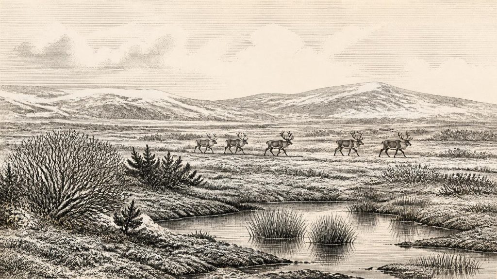
Cold, wind and seasonality were fundamental forces in daily ecology. The evidence does not support the idea of a forested Ireland. Open ground predominated: tundra-like and steppe-tundra mosaics, with grasses, sedges, herbs, mosses and low shrubs. Productive patches around water could sit beside bare mineral ground, frost-shattered slopes and seasonally saturated hollows. Snow cover and frozen ground restricted plant growth for much of the year. Summers may nevertheless have produced short, valuable bursts of grazing and wetland vegetation.
Derryvree’s Buried Wetland
Derryvree provides the clearest local guide. Road works in 1969 cut through a drumlin and revealed freshwater silts and fine sands between two tills: deposits made after one phase of ice action and before another. The organic layer contained plant macrofossils, pollen, mosses and insect remains. Together they point to a treeless muskeg or wet tundra environment with shallow open pools, abundant organic matter and mossy margins. Sedges and grasses were important; finds including dwarf willow, juniper, mountain-avens, bogbean and water-milfoil show that the landscape was ecologically varied rather than uniformly barren.
This is evidence for a particular Fermanagh basin, not a complete photograph of Ireland. Pollen was poorly preserved, the radiocarbon determination has a large error range, and a deposit may accumulate over generations or centuries. Still, the sequence establishes a crucial fact: at some point in the broad interval embracing 31,508 BCE, freshwater habitats and tundra vegetation existed in at least part of northern Ireland before later ice covered them. The drumlin that conceals the deposit is a reminder that glaciers were agents of destruction as well as preservation.
The Animals of Open Country
Cave assemblages in southern Ireland, especially at Castlepook near Doneraile in County Cork, reveal a rich pre-Last Glacial Maximum fauna. Reindeer, woolly mammoth, giant deer, brown bear, wolf, Arctic fox, mountain hare, lemmings and spotted hyaena have all been identified among material from Castlepook or comparable southern cave contexts. Not all specimens were contemporary, and the cave sediments were disturbed in places by antiquarian excavations and natural processes. The assemblage cannot be read as a single herd drinking at one pool. It does show, however, that cold-adapted animals repeatedly reached and occupied Irish landscapes during MIS 3.
Reindeer are especially evocative of the period. Their presence indicates open country with seasonal forage, but it does not prove a predictable annual migration route through the Ballyhoura foothills. Mammoth and giant deer suggest substantial herbivore biomass at some times; hyaenas and wolves point to scavenging and predation within that food web. Caves could be dens, carnivore refuges, traps, places into which bones were dragged, or locations where remains accumulated after death. A fossil bone is evidence of an animal and its environment, not automatically of hunting.
Re-dating has also altered the chronology. Improved collagen pretreatment and accelerator methods showed that several older Castlepook determinations were too young, shifting some animals farther back into MIS 3. That revision matters because it demonstrates how scientific history changes: a date is not a timeless label attached permanently to an object, but a measurement whose reliability depends on sample preservation, laboratory technique and stratigraphic context.
The Human Question
The human story at this date must remain cautious. Ireland has no securely excavated Upper Palaeolithic occupation of roughly 33,500 calibrated years BP: no associated lithic assemblage, hearth, dwelling, human skeleton or repeated butchered-animal deposit. The best-established Palaeolithic evidence for people in Ireland is much later. At Alice and Gwendoline Cave in County Clare, a brown-bear patella bearing cutmarks was independently dated to about 12,810–12,590 and 12,810–12,685 calibrated years BP. It demonstrates human activity in the terminal Pleistocene, not at the much earlier date considered here.
A reindeer femur from Castlepook has attracted discussion because a deep linear modification has been interpreted as potentially made by a sharp stone tool on fresh bone. If that interpretation survives further scrutiny, it may signal a human visit or carcass processing during the wider MIS 3 era. Its implications would be considerable: mobile Upper Palaeolithic hunter-gatherers elsewhere in north-west Europe possessed sophisticated stone technologies and followed animal resources across severe landscapes. But the Castlepook bone comes from an old collection rather than a modern, tightly controlled occupation excavation. Its date concerns the animal’s death, while the mark must be distinguished from carnivore damage, breakage, sediment movement and later handling. It cannot establish settlement, ancestry, language, social organisation or a continuous population.
Life Beyond the Evidence
For that reason, political affairs, formal diplomacy, organised warfare, trade networks, religious rites and systems of learning are unknown for Ireland at this horizon. It would be misleading to import them from the cave-art regions of France or Iberia, however impressive those contemporary European records may be. If people did reach Ireland, they may have travelled in small, mobile groups whose survival depended on knowledge of animals, weather, stone and routes. That is an inference from the broader Upper Palaeolithic world, not a demonstrated Irish social portrait.
The strongest history of 31,508 BCE is environmental and methodological. Fermanagh’s silts indicate that freshwater wetlands and tundra plants could flourish between glacial episodes. Cork’s caves show that large herbivores and predators reached the island during MIS 3. Later ice removed much of the potential archaeological record, leaving a scattered archive of bones, mud and pollen. Ireland at this point was neither a known human homeland nor a blank wasteland: it was a changing cold-country landscape, inhabited certainly by animals and open, at least in principle, to movements that archaeology has only begun to test.
Primary Sources
- A Middle Midlandian Freshwater Series at Derryvree, Maguiresbridge, County Fermanagh, Northern Ireland
- Palaeoecology
- Figure 6.— The Subdivision of the Quaternary Period in Ireland
- The Irish Quaternary Fauna Project
- A Reconsideration of the Radiocarbon Dating of the Marine Isotope Stage 3 Fauna from Southern Ireland
- Phylogeographic, Ancient DNA, Fossil and Morphometric Analyses Reveal Ancient and Modern Introductions of a Large Mammal: the Complex Case of Red Deer (Cervus elaphus) in Ireland
- First Evidence of a Late Upper Palaeolithic Human Presence in Ireland
- New Insights on the Fauna of Ireland's Younger Dryas and Early Holocene from Alice & Gwendoline Cave
- Maximum Extent and Dynamic Behaviour of the Last British–Irish Ice Sheet West of Ireland
- Early Deglaciation of the British-Irish Ice Sheet on the Atlantic Shelf Northwest of Ireland Driven by Glacioisostatic Depression and High Relative Sea Level
- Oscillating Retreat of the Last British-Irish Ice Sheet on the Continental Shelf Offshore Galway Bay, Western Ireland
- The Deglaciation of the Western Sector of the Irish Ice Sheet from the Inner Continental Shelf to its Terrestrial Margin
- Radiocarbon Constraints on the Age of the Maximum Advance of the British–Irish Ice Sheet in the Celtic Sea
- Stratigraphic and Palaeo-geomorphological Evidence for the Glacial-deglacial History of the Last British-Irish Ice Sheet in the North-western Irish Sea
- The Timing and Magnitude of the British–Irish Ice Sheet Between Marine Isotope Stages 5d and 2: Implications for Glacio-isostatic Adjustment, High Relative Sea Levels and ‘Giant Erratic’ Emplacement
- Deglacial Rates and Controls for BIIS Western Margin
- Exploring Controls of the Early and Stepped Deglaciation on the Western Margin of the British Irish Ice Sheet
- The Archaeology of Caves in Ireland
- IntCal20 Northern Hemisphere Radiocarbon Age Calibration Curve (0–55 cal kBP)
- Anthropogenic Changes to the Holocene Nitrogen Cycle in Ireland