
Derryvree’s Drumlin Archive31310 BCE
Around 31,310 BCE, Ireland’s history is reconstructed from environmental evidence rather than written records. Derryvree in County Fermanagh preserves freshwater sediments between glacial tills, indicating a cold, treeless tundra wetland during part of MIS 3, when local ice retreated before returning. Its radiocarbon date spans a broad calibrated interval encompassing the notional year, not a precise event. Castlepook Cave in Cork records diverse cold-stage fauna, including reindeer, mammoth and hyaena, accumulated over time. A possibly butchered reindeer bone suggests human activity, but not settlement. Uneven ice-sheet growth, changing sea levels and limited evidence preclude island-wide conclusions about conditions or occupation.
Dateline
Modern calendar-year precision is not available for Ireland in 31,310 BCE. Nobody on the island recorded a year in this form, and the surviving evidence cannot isolate an event, a season or a generation so precisely. Converted into the archaeological convention of calibrated years before present, where “present” is AD 1950, the label sits at roughly 33,260 cal BP. It belongs to the Late Pleistocene, within Marine Isotope Stage 3 (MIS 3), a long and markedly unstable part of the last Ice Age. The responsible history of this moment is therefore not a chronicle of rulers or battles, but a reconstruction from buried freshwater deposits, cave bones, glacial sediments and the changing methods used to date them.
A Date Within a Broad Interval
The closest Irish environmental archive is at Derryvree townland, near Maguiresbridge in County Fermanagh. Roadworks in 1969 cut through a drumlin and revealed a remarkable sequence: thick glacial till below, freshwater silts and fine sands in the middle, and another thick till above. Till is the unsorted debris left directly by glacier ice. The order of the deposits establishes a powerful relative sequence. Ice had crossed the locality; an interval then followed in which open water, sediment and organic material accumulated; and ice later returned, burying the evidence beneath a new sheet of debris. The drumlin thus preserves a fragment of a landscape otherwise vulnerable to being scoured away by later glaciation.
Organic material from the intervening deposit gave the conventional radiocarbon determination Birm-166, about 30,500 radiocarbon years BP, with an uncertainty of more than a millennium. A radiocarbon age is not a calendar age. Atmospheric carbon-14 has varied over time, so measurements must be calibrated against an internationally maintained curve; at this antiquity, a single laboratory result can correspond to a broad calendar range. Published discussion places Derryvree’s deposit broadly between about 36,900 and 31,700 calibrated years BP. The notional year 31,310 BCE falls inside that span, but cannot be pinned to a particular layer, animal or episode within it.
Fresh Water Between the Ice
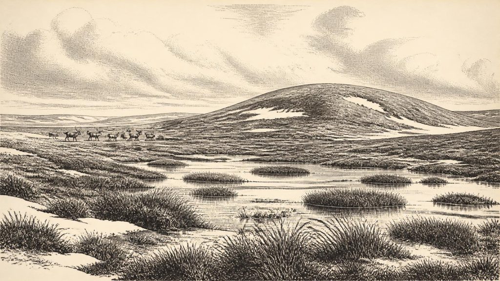
The Derryvree evidence indicates locally ice-free ground in Fermanagh during part of later MIS 3, not an island-wide map for a single date. Its plants, mosses, insects and freshwater organisms point to a landscape of open tundra and periglacial wetland: treeless country, cold soils, shallow water and seasonally productive margins rather than forest. Such terrain could include sedges, hardy herbaceous plants and wet hollows where organic remains had a chance to survive. The original investigators described the flora and fauna as having a “full glacial” character. That is evidence for harsh conditions, but not for permanent deep snow in every season or an unchanging climate across the island.
Fermanagh’s low ground was also not a static wilderness. Water levels, freezing and thawing, sediment movement and vegetation cover would have shifted over years and centuries. Permafrost or seasonally frozen ground could hinder drainage, while summer meltwater made pools and channels. The modern drumlin landscape conceals this older terrain, but Derryvree shows that the familiar glacial landform contains a sequence of radically different environments: ice, then freshwater wetland, then ice again. It is a reminder that “Ice Age Ireland” was not one uniform frozen scene, but a succession of changing local worlds.
Approaching Major Glaciation
At approximately 33,260 cal BP, Ireland lay before the later maximum spread of the British–Irish Ice Sheet, but within the wider build-up of glaciation in north-west Europe. Reconstructions of the ice sheet stress that evidence before 31,000 cal BP is patchy and uncertain. By around 31,000 cal BP, however, models identify ice accumulation in Northern Ireland among several developing centres, while the ice sheet expanded rapidly in succeeding millennia. That wider history makes Derryvree’s two tills especially significant: they demonstrate real changes in ice occupation at one Fermanagh location, while also warning against treating any single section as a complete map of Ireland.
There is no responsible basis for describing the whole island in 31,310 BCE as either entirely ice-covered or entirely ice-free. Upland ice, advancing margins and ice-free tracts may all have existed in different places and at different times. Nor can the modern coastline simply be projected backwards. Sea level and the configuration of ice strongly affected the Irish Sea basin and routes between Ireland, Britain and continental Europe. The question of access was environmental and changeable, not a dependable “land bridge” that can be assumed for every part of the Ice Age.
Castlepook’s Animal World
Southern Ireland supplies a complementary, although differently problematic, record. Castlepook Cave, also known as Mammoth Cave, near Doneraile in County Cork, produced a very large collection during excavations led by Richard J. Ussher and colleagues in the early twentieth century. Reindeer remains were especially numerous, while the wider assemblage included woolly mammoth, giant deer, brown bear, wolf, Arctic fox, lemmings and spotted hyaena. The National Museum of Ireland regards Castlepook as the country’s most important site for mammal remains from the last cold stage; its spotted-hyaena material belongs to a fauna that reached Ireland from Britain during the Late Pleistocene.
That list should not be turned into a single imagined parade of animals in one valley in 31,310 BCE. Cave assemblages build up over time. Carnivores may drag prey into dens; bones can be disturbed, redeposited or mixed; and old excavations often recorded their positions less precisely than modern fieldwork requires. Recent re-dating of Castlepook bones with improved pretreatment has shown that some earlier radiocarbon results were substantially too young, with revised dates placing important elements of the fauna in MIS 3. The resulting picture is richer, but also more cautious: Castlepook documents an Ice Age animal community over a long interval, not a dated census for one calendar year.
Nevertheless, the animal evidence matters for everyday ecology. Reindeer imply open grazing country and could move seasonally across wide territories. Mammoths and giant deer required substantial forage; hyaenas, wolves and bears indicate predator and scavenger relationships that shaped where carcasses accumulated. Caves offered shelter to animals and repositories for bone, but do not automatically show that people lived in them. In this sense the economy visible in the record is an ecological one: plants supported herbivores, herbivores supported predators and scavengers, and waterlogged or sheltered places selectively preserved the traces.
The Human Question
A reindeer femur from Castlepook has been reported as bearing deep marks interpreted as stone-tool butchery and as dating to about 33,000 years ago. If that interpretation is upheld, it would be an exceptionally early indication that people processed a carcass in Ireland during the Upper Palaeolithic. It would not demonstrate a permanent settlement, a resident population, a camp at Castlepook or continuous occupation of the island. No securely dated house, hearth, lithic workshop, grave, store of food or body of art can presently be assigned to Ireland around this point in MIS 3. Recent excavations have specifically sought surviving Pleistocene deposits in the cave, reflecting how much remains to be learned from the site.
This distinction is essential when discussing society, culture and politics. There is no evidence for Irish polities, leaders, territories, diplomacy, organised warfare, trade networks, agriculture or formal religion in 31,310 BCE. If small mobile groups did visit, their movements would have been structured by weather, animal availability, terrain and access across the surrounding region, not by institutions recorded in the archaeological record. The possible cut-marked bone is evidence of an action, if correctly identified; ideas about the size, identity, language, beliefs or social organisation of those responsible remain interpretation beyond the evidence.
What This Year Can Mean
The most historically meaningful development around this notional year is environmental volatility. In Fermanagh, freshwater life occupied a cold wetland between episodes of glaciation. In Cork, a cave archive preserves evidence that a diverse cold-stage fauna reached the island over MIS 3. At the regional scale, ice sheets were developing unevenly and would eventually remodel much of the terrain and erase much older evidence. Ireland was therefore neither a blank space nor a known human homeland: it was a changing northern landscape, sparsely documented but scientifically legible through its sediments and bones.
Its history must remain proportionate to the evidence. Derryvree provides the clearest local window close to 31,310 BCE; Castlepook provides the strongest evidence for the wider animal world and a tantalising, still limited human question. Together they show why calendar labels this remote are useful only as signposts. The real subject is a broad calibrated interval in which ice, water, plants and animals left traces capable of outlasting almost everything else.
Primary Sources
- A Middle Midlandian Freshwater Series at Derryvree, Maguiresbridge, County Fermanagh, Northern Ireland
- A Reconsideration of the Radiocarbon Dating of the Marine Isotope Stage 3 Fauna from Southern Ireland
- Growth and Retreat of the Last British–Irish Ice Sheet, 31,000 to 15,000 Years Ago: The BRITICE-CHRONO Reconstruction
- Pattern, Style and Timing of British–Irish Ice Sheet Advance and Retreat Over the Last 45,000 Years: Evidence from NW Scotland and the Adjacent Continental Shelf
- Pattern, Style and Timing of British–Irish Ice Sheet Retreat: Shetland and Northern North Sea Sector
- Character of Advance and Retreat of the Southwest Sector of the British-Irish Ice Sheet During the Last Glaciation
- Deglacial Rates and Controls for BIIS Western Margin
- Freshwater Organic Deposits and Stratified Sediments Between Early and Late Midlandian (Devensian) Till Sheets, at Aghnadarragh, County Antrim, Northern Ireland
- The IntCal20 Northern Hemisphere Radiocarbon Age Calibration Curve (0–55 cal kBP)
- IntCal Publications
- IntCal Data
- A Stratigraphic Framework for Abrupt Climatic Changes During the Last Glacial Period Based on Three Synchronized Greenland Ice-Core Records
- Ireland: Submerged Prehistoric Sites and Landscapes
- The Problem of a Late Quaternary Landbridge Between Britain and Ireland
- Spotted Hyena Skull
- Prehistoric Details
- Heritage Artefacts of County Cork 2021
- 2022:564 – Castlepook Cave, Castlepook South, Cork
- New Insights on the Fauna of Ireland’s Younger Dryas and Early Holocene from Alice & Gwendoline Cave
- The Irish Quaternary Fauna Project
