

Derryvree’s Trifoliate Record31248 BCE
At the notional date of 31,248 BCE, Ireland’s evidence cannot support an annual history, but illuminates a broad, variable Late Pleistocene interval. Derryvree, County Fermanagh, preserves freshwater sediments between glacial tills, dated broadly to 36,900–31,700 years BP, indicating locally ice-free, open wet tundra with sedges, mosses, juniper and bogbean. Ice-sheet extent and sea levels varied regionally before the later Last Glacial Maximum. Castlepook Cave, County Cork, contains cold-climate fauna, including reindeer and mammoth. A cut-marked reindeer femur may indicate human carcass processing, but cannot prove settlement. Glaciation and erosion have left Ireland’s ecological past clearer than its human history alone.
Dateline
Modern calendar-year precision is not available for Ireland in 31,248 BCE. Nobody on the island recorded time in numbered years, and neither radiocarbon dating nor glacial stratigraphy can identify an event within a particular twelve-month span so far back. In the archaeological convention of years before AD 1950, the label falls roughly 33,200 years before present, within the Late Pleistocene and Marine Isotope Stage 3 (MIS 3), a cold and highly variable phase of the last Ice Age. The appropriate subject is therefore not an invented annual chronicle, but the fragmentary environmental and archaeological evidence that can illuminate Ireland across a broad interval surrounding this notional date.
A Date Within a Deep Range
The strongest chronological warning comes from the nature of the evidence itself. A radiocarbon determination measures the remaining carbon-14 in once-living material, not a modern calendar date. Calibration is needed because atmospheric carbon-14 levels changed over time; at great age, the calibration process and the uncertainty of the original measurement yield ranges of centuries or millennia. Geological deposits also establish sequence especially well—what lay beneath, above, or between other deposits—but not a diary-like date for each layer.
For 31,248 BCE, the most useful Irish anchor is the Derryvree site near Maguiresbridge in County Fermanagh. Road excavations in 1969 cut through a drumlin, exposing freshwater silts and fine sands enclosed between two substantial tills: unsorted sediment deposited by glacier ice. Organic material in the intervening deposit produced the radiocarbon date BIRM-166, 30,500 +1,170/-1,030 radiocarbon years BP. Later discussion calibrates this broadly to about 36,900–31,700 calendar years BP, approximately 34,950–29,750 BCE. The numbered year considered here lies within that wide span. It cannot be assigned to a particular pool, plant, animal or human act in the Derryvree sequence.
The order of the deposits is nevertheless exceptionally important. An earlier glacier formed the lower till; during a subsequent non-glacial interval, water and sediment accumulated in a low place; a later advance laid down the upper till and sealed the freshwater record. Derryvree consequently demonstrates that this part of Fermanagh experienced conditions capable of sustaining freshwater habitats during a cold interval before renewed glaciation. It does not prove that all of Ireland was ice-free at the same time, or that conditions across the island were uniform.
Wet Tundra Under a Harsh Sky
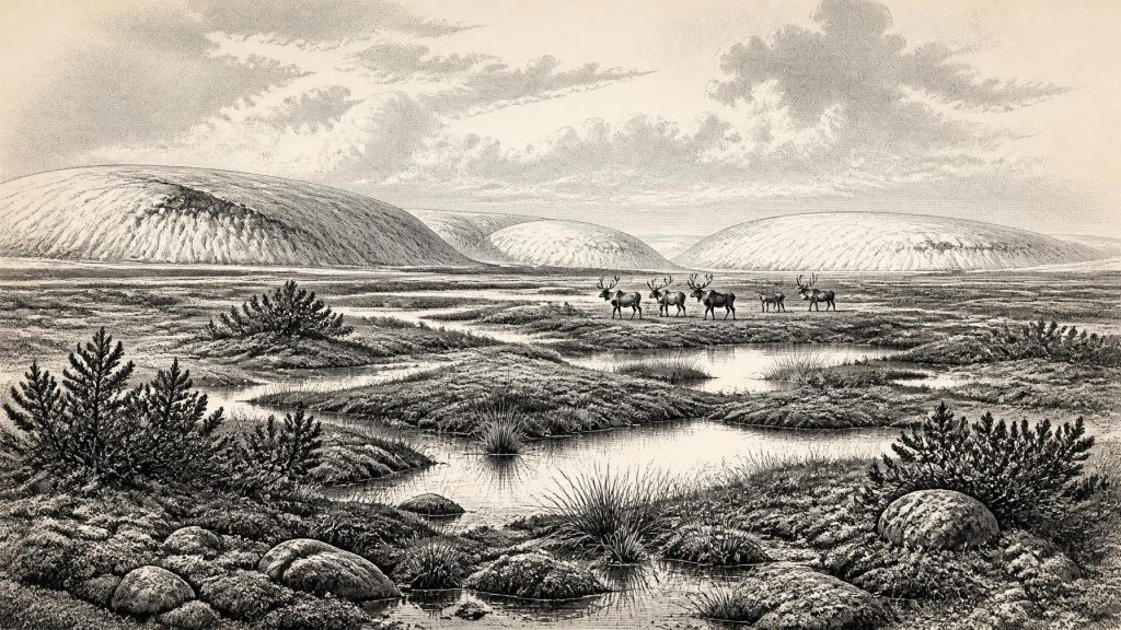
The Derryvree sediments preserve pollen, plant macrofossils, mosses and insect remains. Their combined evidence supports an open, largely treeless tundra or muskeg-like landscape: waterlogged ground, shallow pools, mossy margins and plant-rich sedge beds, set amid sparse dry-ground vegetation. Grasses, sedges, herbs, juniper and cold-adapted mosses are more appropriate images than the oak woods, hedged fields and pasture often associated with later Ireland. A seed of bogbean, Menyanthes trifoliata, is especially evocative evidence for freshwater vegetation in this severe setting.
These remains are evidence for local ecology, not a complete reconstruction of a whole island. Pollen may travel, material may be reworked, and a sedimentary hollow naturally records its immediate catchment more fully than distant uplands or coasts. Even so, the agreement between several kinds of fossil evidence makes the broad interpretation persuasive: south Fermanagh contained cold, open ground with wet hollows and standing water during part of MIS 3. Winters were severe, summers short, and plant growth seasonal. Such a terrain would have altered rapidly as snow cover, frost, meltwater and the edge of nearby ice changed.
MIS 3 was not one unbroken climatic state. Greenland ice-core records show abrupt shifts between relatively milder interstadials and colder stadials, often on timescales far shorter than conventional archaeological periods. Ireland’s record is too discontinuous to match every such shift securely to a particular locality. Yet the Derryvree deposits make the larger point clear: Late Pleistocene Ireland was environmentally dynamic. Its rivers, wetlands, vegetation and animal habitats responded to changes in temperature and precipitation, while glaciers repeatedly advanced, retreated or reorganised.
Ice, Sea and Regional Difference
At around 33,200 years before present, Ireland was approaching the greatest expansion of the last British–Irish Ice Sheet, but it should not be pictured simply as an island either wholly frozen or wholly open. Evidence from Derryvree records an ice-free episode in Fermanagh within a broad date range. Other research, particularly from western Ireland and the offshore shelf, indicates that ice-sheet behaviour before the Last Glacial Maximum was more complicated than older single-advance models allowed. Some reconstructions infer extensive ice or high relative sea level in western sectors during parts of the 40,000–19,000 calendar-year-BP interval; other evidence places the maximum later and shows pronounced regional variation.
The responsible conclusion is uncertainty with boundaries. Ice was a major force in the Irish landscape, and its expansion would later cover or reshape large areas, eroding older surfaces and making survival of sites exceptionally unlikely. But Derryvree shows that ice-free freshwater environments existed at least locally during the broader period. The Last Glacial Maximum proper came later, conventionally placed around 26,000–20,000 years BP, though the timing and extent of its Irish margins remain matters of active reconstruction.
Lower global sea levels exposed land now beneath the surrounding seas, changing coastlines and the scale of coastal plains. This did not make movement into Ireland straightforward or demonstrable. No secure route, crossing point or contemporary shoreline camp has been found for this date. Much potential evidence may lie beneath later marine deposits, beneath glacial sediment, or may have been destroyed by erosion. Geography made connections with Britain and continental north-west Europe environmentally possible in changing ways; archaeology has not yet documented how, or even how often, people may have made them.
Cave Fauna and One Human Question
County Cork provides the most striking evidence relevant to possible human activity. Castlepook Cave, near Doneraile and also known as Mammoth Cave, has yielded a rich Pleistocene faunal collection. The assemblage includes animals associated with cold and open environments, among them reindeer, woolly mammoth, giant deer, brown bear, hyaena, wolf, Arctic fox, lemmings, stoat and mountain hare. The cave record shows that Ireland was not biologically empty before the full glacial maximum. It was occupied, intermittently and unevenly, by a changing community of large herbivores, predators and smaller cold-adapted animals.
That list must not be turned into a single illustrated scene. Cave deposits frequently accumulate over long periods. Carnivores can drag in bones; water, frost, collapse, excavation and museum collecting can disturb their original positions. The Castlepook animals need not all have lived together, and their remains do not identify an unchanging local ecosystem. The cave was probably used differently by animals at different times: as a shelter, den, scavenging place or trap-like accumulation point. Mammoth and hyaena remains, in particular, underline how unlike later historic Ireland this Ice Age fauna was.
A reindeer femur from the older Castlepook collection is central to the question of people. It bears a deep linear mark interpreted by palaeozoologist Ruth Carden as having been made on fresh bone with a sharp stone tool during carcass processing. County Cork heritage material has presented the specimen as dating to about 31,000 BC. If that interpretation and association are sustained, it would indicate that people handled a reindeer in Ireland during the Upper Palaeolithic—far earlier than the long-established evidence for human presence after the final glacial retreat.
The limits of that claim are as important as its excitement. The bone comes from an old cave collection, not from a modern excavation yielding a securely recorded occupation floor. No associated hearth, stone-tool assemblage, dwelling, human burial, artwork or repeated food-processing deposit has yet been published for Ireland at this age. A date on the animal establishes when it lived, not automatically when the mark was made or whether people killed it, found it dead, took meat or sinew, or worked the limb elsewhere before carnivores moved it. The marked femur is possible evidence of a brief visit or carcass processing episode, not proof of permanent settlement.
Lives Beyond the Record
There is consequently no evidence for political affairs, diplomacy, named groups, leaders, territorial boundaries, organised warfare, religion or formal learning in Ireland at this point. There is also no basis for asserting farming, herding, pottery, monuments, villages, trade routes or an established population. These absences are meaningful, but they partly reflect preservation: later ice was destructive, and mobile people leave smaller archaeological signatures than farming communities.
If people did reach Ireland, comparison with Upper Palaeolithic groups elsewhere in Europe suggests only possibilities, not Irish facts. Such communities could make sophisticated stone tools, manage fire, prepare hides, travel widely and maintain social connections across large territories. None of those capacities can be assigned to an Irish group from the Castlepook femur alone. The modest inference is that a human-made cut, if confirmed, would require a sharp implement and knowledge of carcass processing. It would say nothing secure about language, belief, kinship, population size or duration of residence.
The economy most securely visible at 31,248 BCE is ecological rather than human: plants exploiting brief growing seasons; insects and small mammals inhabiting wet tundra; herbivores moving through open country; predators and scavengers using caves and carcasses; and meltwater building silts in sheltered basins. Derryvree’s bogbean seed and Castlepook’s reindeer bone are small survivals from that wider system. Together they reveal an Ireland that was cold, regionally varied and repeatedly transformed by ice—an inhabited landscape in the biological sense, but not yet a historically legible society.
For this distant date, then, the most honest annual overview is a lesson in scale. The evidence permits a carefully drawn environmental world and a tantalising question about human visitation. It does not permit a story of “the Irish” in a particular year. The deep record is richest where it remains most humble: a wetland sealed beneath a Fermanagh drumlin, a cave bone from north Cork, and the recognition that both ice and time have removed far more than they left behind.
Primary Sources
- A Middle Midlandian Freshwater Series at Derryvree, Maguiresbridge, County Fermanagh, Northern Ireland
- Palaeoecology
- Figure 6.— The Subdivision of the Quaternary Period in Ireland
- Landscapes and Environments of the Last Glacial-Interglacial Transition: A Time of Amazingly Rapid Change in Ireland
- Radiocarbon Constraints on the History of the Western Irish Ice Sheet Prior to the Last Glacial Maximum
- Radiocarbon Constraints on the History of the Western Irish Ice Sheet Prior to the Last Glacial Maximum
- Trimlines, Blockfields and the Vertical Extent of the Last Ice Sheet in Southern Ireland
- Growth and Retreat of the Last British–Irish Ice Sheet, 31,000 to 15,000 Years Ago: The BRITICE-CHRONO Reconstruction
- Dating Constraints on the Last British-Irish Ice Sheet: A Map and Database
- Dimensions and Chronology of the Last Ice Sheet in Western Ireland
- Maximum Extent and Dynamic Behaviour of the Last British–Irish Ice Sheet West of Ireland
- Radiocarbon Constraints on the Age of the Maximum Advance of the British-Irish Ice Sheet in the Celtic Sea
- Early Deglaciation of the British-Irish Ice Sheet on the Atlantic Shelf Northwest of Ireland Driven by Glacioisostatic Depression and High Relative Sea Level
- Exposure-Age Constraints on the Extent, Timing and Rate of Retreat of the Last Irish Sea Ice Stream
- The Irish Quaternary Fauna Project
- Heritage Artefacts of County Cork
- First Evidence of a Late Upper Palaeolithic Human Presence in Ireland
- Quaternary Science Reviews 339 (2024) 108827
- Archaeological Excavations at Killuragh Cave, Co. Limerick
- Introduction to the Late Quaternary and Holocene of Northern Ireland
- Menyanthes trifoliata
- The Mesolithic in Ireland: When Was It?








